ATL: FRED- Remnants - Discussion
Moderator: S2k Moderators
-
leanne_uk
- Tropical Storm

- Posts: 214
- Age: 43
- Joined: Fri Sep 04, 2009 4:38 pm
- Location: Loughborough countryside, Leicestershire, UK
Re:
Not sure on whether we have any members over in the Cape Verde Islands but my friend is currently on holiday on Santa Maria.
Safe to say she is very worried about what is happening.... as of yesterday the hotel hadn't given any info on the system and even went as far as booking tour excursions for Monday and Tuesday for them
Safe to say she is very worried about what is happening.... as of yesterday the hotel hadn't given any info on the system and even went as far as booking tour excursions for Monday and Tuesday for them
CrazyC83 wrote:This could be historic. Do we have any members in Cape Verde?
0 likes
-
SouthDadeFish

- Professional-Met

- Posts: 2835
- Joined: Thu Sep 23, 2010 2:54 pm
- Location: Miami, FL
- Contact:
Re: ATL: FRED- Tropical Storm - Discussion
I'll share what I just put on twitter here:
Tropical Storm Fred is a great example of how 37 GHz microwave imagery shows structure other channels can't.
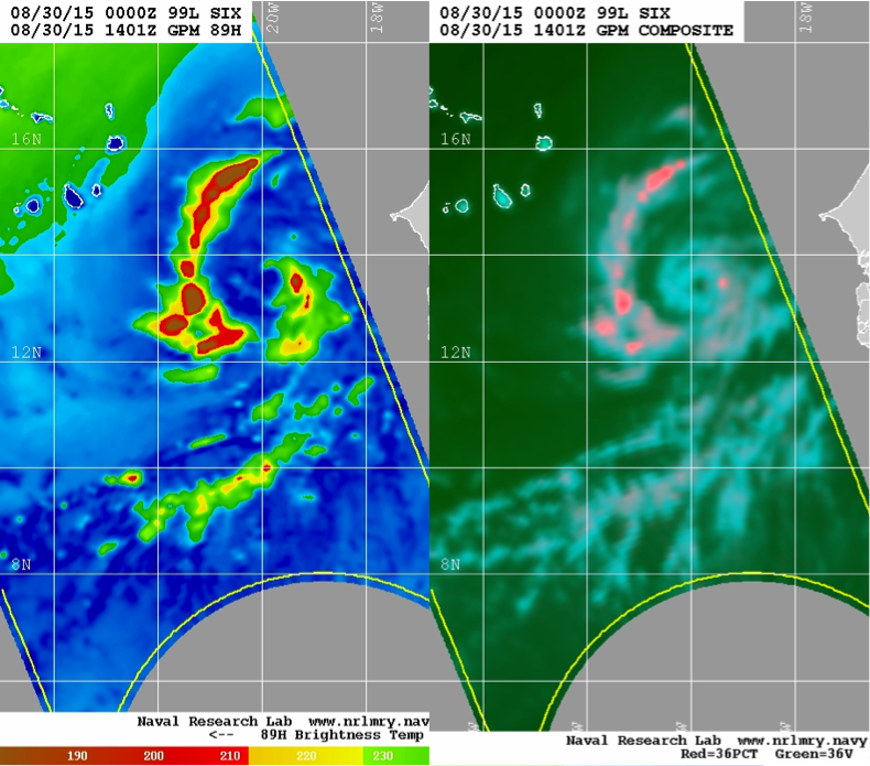
The 36/37 GHz frequency is able to detect shallow convection which is not as easily picked up by the higher frequencies. Fred is looking very good and the presence of the cyan ring leads me to believe rapid intensification into a hurricane is quite possible.
Tropical Storm Fred is a great example of how 37 GHz microwave imagery shows structure other channels can't.
The 36/37 GHz frequency is able to detect shallow convection which is not as easily picked up by the higher frequencies. Fred is looking very good and the presence of the cyan ring leads me to believe rapid intensification into a hurricane is quite possible.
0 likes
-
TheAustinMan

- Category 5

- Posts: 1060
- Joined: Mon Jul 08, 2013 4:26 pm
- Location: Central TX / United States
Fred's current appearance reminds me of Tropical Storm Josephine back in 2008, which also developed an eye feature far east near Cape Verde. Below I've placed Fred on the left and Josephine on the right. Images are to scale.

0 likes
Treat my opinions with a grain of salt. For official information see your local weather service.
“It's tough to make predictions, especially about the future.”
“It's tough to make predictions, especially about the future.”
-
WPBWeather

- S2K Supporter

- Posts: 535
- Age: 67
- Joined: Thu Jul 18, 2013 12:33 pm
Re:
psyclone wrote:what an impressive storm..big, symmetrical and very un-atlantic like.
Well since 2004 and 2005, anyway.
0 likes
-
northjaxpro

- S2K Supporter
- Posts: 8900
- Joined: Mon Sep 27, 2010 11:21 am
- Location: Jacksonville, FL
Fred is an impressive tropical cyclone. He was very organized over land as a wave while i was tracking it in Africa long before moving off the coast. It is just below hurricane strength now. I think history will be made with Fred bringing the Cape Verde Islands to experience only their third hurricane on record. That is truly a remarkable statistic there.
0 likes
NEVER, EVER SAY NEVER in the tropics and weather in general, and most importantly, with life itself!!
________________________________________________________________________________________
Fay 2008 Beryl 2012 Debby 2012 Colin 2016 Hermine 2016 Julia 2016 Matthew 2016 Irma 2017 Dorian 2019
________________________________________________________________________________________
Fay 2008 Beryl 2012 Debby 2012 Colin 2016 Hermine 2016 Julia 2016 Matthew 2016 Irma 2017 Dorian 2019
-
SunnyThoughts
- Category 5
- Posts: 2263
- Joined: Wed Jul 09, 2003 12:42 pm
- Location: Pensacola, Florida
-
HURAKAN

- Professional-Met
- Posts: 46084
- Age: 39
- Joined: Thu May 20, 2004 4:34 pm
- Location: Key West, FL
- Contact:
Re: ATL: FRED- Tropical Storm - Discussion
Lifeless wrote:cycloneye wrote:We are witnessing history here.Only two Hurricanes have crossed the Cape Verde Islands since 1850.
[img][/img]
Debbie was one of the storms that almost hit Ireland as a Category 1 Hurricane too, only got downgraded to a extra-tropical storm as it made its final approach, although the effects on Ireland were just as bad. Lets hope that a possible history-making event doesn't cause too much harm as it passes through.
reanalysis suggests that Debbie became extratropical close to the Azores
0 likes
-
leanne_uk
- Tropical Storm
- Posts: 214
- Age: 43
- Joined: Fri Sep 04, 2009 4:38 pm
- Location: Loughborough countryside, Leicestershire, UK
Web cam from Santa Maria.... not a live feed tho, updates once a minute. http://www.capeverde.com/live-webcams/s ... maria.html
Found another site with a number of feeds from different parts if the islands.... http://www.meteosurfcanarias.com/en/002 ... -maria.php
http://www.mytravelcams.com/network/cam ... maria.html
Found another site with a number of feeds from different parts if the islands.... http://www.meteosurfcanarias.com/en/002 ... -maria.php
http://www.mytravelcams.com/network/cam ... maria.html
0 likes
-
Extratropical94

- Professional-Met
- Posts: 3545
- Age: 31
- Joined: Wed Oct 20, 2010 6:36 am
- Location: Hamburg, Germany
- Contact:
TROPICAL STORM FRED INTERMEDIATE ADVISORY NUMBER 3A
NWS NATIONAL HURRICANE CENTER MIAMI FL AL062015
200 PM AST SUN AUG 30 2015
...FRED CONTINUES TO STRENGTHEN...
...OUTER RAIN BANDS NEARING THE EASTERNMOST CAPE VERDE ISLANDS...
SUMMARY OF 200 PM AST...1800 UTC...INFORMATION
----------------------------------------------
LOCATION...14.1N 20.7W
ABOUT 195 MI...315 KM ESE OF PRAIA IN THE CAPE VERDE ISLANDS
MAXIMUM SUSTAINED WINDS...60 MPH...95 KM/H
PRESENT MOVEMENT...NW OR 310 DEGREES AT 16 MPH...26 KM/H
MINIMUM CENTRAL PRESSURE...1000 MB...29.53 INCHES
0 likes
54° 11' 59'' N, 9° 9' 20'' E
Boomer Sooner!
Go Broncos! Go Cards!
Clinching counties, one at a time: https://mob-rule.com/user-gifs/USA/xtrp94.gif
- Daniel
Boomer Sooner!
Go Broncos! Go Cards!
Clinching counties, one at a time: https://mob-rule.com/user-gifs/USA/xtrp94.gif
- Daniel

Re:
Alyono wrote:really cranking up quickly based upon 15 minute meteosat imagery. May be a hurricane within the next few hours at this rate
What do you think the upper limit for this thing is for Cape Verde?
0 likes
Re: Re:
RL3AO wrote:Alyono wrote:really cranking up quickly based upon 15 minute meteosat imagery. May be a hurricane within the next few hours at this rate
What do you think the upper limit for this thing is for Cape Verde?
worst case, 75 to 80 kts
0 likes
-
tolakram
- Admin

- Posts: 20179
- Age: 62
- Joined: Sun Aug 27, 2006 8:23 pm
- Location: Florence, KY (name is Mark)
Re: ATL: FRED- Tropical Storm - Discussion
Live loop from this area.
shift and drag to zoom in, then select number of frames to loop.
http://oiswww.eumetsat.org/IPPS/html/MSG/RGB/NATURALCOLOR/FULLRESOLUTION/index.htm
shift and drag to zoom in, then select number of frames to loop.
http://oiswww.eumetsat.org/IPPS/html/MSG/RGB/NATURALCOLOR/FULLRESOLUTION/index.htm
0 likes
M a r k
- - - - -
Join us in chat: Storm2K Chatroom Invite. Android and IOS apps also available.
The posts in this forum are NOT official forecasts and should not be used as such. Posts are NOT endorsed by any professional institution or STORM2K.org. For official information and forecasts, please refer to NHC and NWS products.
-
tolakram
- Admin
- Posts: 20179
- Age: 62
- Joined: Sun Aug 27, 2006 8:23 pm
- Location: Florence, KY (name is Mark)
Re: ATL: FRED- Tropical Storm - Discussion
latest

0 likes
M a r k
- - - - -
Join us in chat: Storm2K Chatroom Invite. Android and IOS apps also available.
The posts in this forum are NOT official forecasts and should not be used as such. Posts are NOT endorsed by any professional institution or STORM2K.org. For official information and forecasts, please refer to NHC and NWS products.
- - - - -
Join us in chat: Storm2K Chatroom Invite. Android and IOS apps also available.
The posts in this forum are NOT official forecasts and should not be used as such. Posts are NOT endorsed by any professional institution or STORM2K.org. For official information and forecasts, please refer to NHC and NWS products.
-
TheProfessor

- Professional-Met
- Posts: 3506
- Age: 29
- Joined: Tue Dec 03, 2013 10:56 am
- Location: Wichita, Kansas
Is this a fairly certain early recurve? because if Fred decides to defy the models like Danny and Erika did then Fred could be an interesting watch over the next week.
0 likes
An alumnus of The Ohio State University.
Your local National Weather Service office is your best source for weather information.
Your local National Weather Service office is your best source for weather information.

Re: Re:
WPBWeather wrote:psyclone wrote:what an impressive storm..big, symmetrical and very un-atlantic like.
Well since 2004 and 2005, anyway.
People seem quick to forget the tons of major hurricanes we had in 2007-08 and 10, the Atlantic didn't really start struggling until 2011...
0 likes
The above post is not official and should not be used as such. It is the opinion of the poster and may or may not be backed by sound meteorological data. It is not endorsed by any professional institution or storm2k.org. For official information, please refer to the NHC and NWS products.
Re: Re:
Hammy wrote:WPBWeather wrote:psyclone wrote:what an impressive storm..big, symmetrical and very un-atlantic like.
Well since 2004 and 2005, anyway.
People seem quick to forget the tons of major hurricanes we had in 2007-08 and 10, the Atlantic didn't really start struggling until 2011...
its really only been since 2013. We had 3 cat 3s in 2011 and I believe 11 hurricanes in 2012
0 likes
Who is online
Users browsing this forum: No registered users and 52 guests