ATL: ERIKA - Remnants - Discussion

Moderator: S2k Moderators

Message
Author
ozonepete
Professional-Met
Professional-Met
Posts: 4743
Joined: Mon Sep 07, 2009 3:23 pm
Location: From Ozone Park, NYC / Now in Brooklyn, NY

Re: ATL: ERIKA - Tropical Storm - Discussion

#1741 Postby ozonepete » Thu Aug 27, 2015 4:37 pm

hurricanedude wrote:so question for anyone who wants to go even further into the future......once Erika is done with florida...assuming it takes the northern track how far up the east coast does it ride b4 getting kicked out or is this one that could ride the whole coast all the way to maine?


Impossibly too far out in the future. there are models going out that far and they indicate that this might stall over the Carolinas but I wouldn't bet a cent on a forecast that far out. Just keep watching.
0 likes   

TheStormExpert

#1742 Postby TheStormExpert » Thu Aug 27, 2015 4:38 pm

On it's closest approach to where I live it's about 10miles off the coast. :eek:

Hopefully the track shifts east again.

Image
0 likes   

USTropics
Professional-Met
Professional-Met
Posts: 2659
Joined: Sun Aug 12, 2007 3:45 am
Location: Florida State University

Re: Re:

#1743 Postby USTropics » Thu Aug 27, 2015 4:40 pm

JGrin87 wrote:
ozonepete wrote:
AutoPenalti wrote:What exactly is an anti-cyclone?


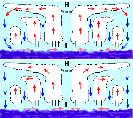
A high pressure area where winds blow in a clockwise direction around the center. A hurricane is a large cyclone where winds blow counterclockwise around the center. But up at around 200 - 300 mb or 30,000 feet and up, a well developed hurricane has an anti-cyclone (high pressure) are above it. That anti-cyclone takes all of that extremely fast uprushing air and blows it out away from the storm. So it's the exhaust system. Without it the hurricane would be like a fireplace where you covered over the chimney - the fire would die out.


Fixed "hurricane is large cyclone" lol


Is this (i.e. the high pressure area above the cyclone) the reason an eye develops or clears out all convection/clouds in the center?


It's kind of a combination of multiple factors. In the most simplest of terms, anticyclones create outflow boundaries, allowing the system to vent the moist rising air (convergence) once it reaches the upper levels. When you have a vertically stacked system at the low, mid, and upper level, you'll have optimal conditions for rapid converging and then diverging air, increasing vorticity. The center of that ends up being the eye.

Image
Last edited by USTropics on Thu Aug 27, 2015 4:45 pm, edited 2 times in total.
0 likes   

User avatar
CronkPSU
S2K Supporter
S2K Supporter
Posts: 2014
Joined: Sun Aug 07, 2005 10:44 pm
Location: Avalon Park, FL

Re: ATL: ERIKA - Tropical Storm - Discussion

#1744 Postby CronkPSU » Thu Aug 27, 2015 4:41 pm

Hurricaneman wrote:
yep, I have a lot of non perishable foods and lots of water and batteries just in case and if nothing happens we don't have to buy that stuff for a while


Same here, we live so close to the power plant with underground lines so I doubt we would be without power long but I am prepping tonight like we weren't cause you never know
0 likes   
Just like Jon Snow..."I know nothing" except what I know, and most of what I know is gathered by the fine people of the NHC

psyclone
S2K Supporter
S2K Supporter
Posts: 4769
Joined: Wed Aug 24, 2005 9:04 pm
Location: palm harbor fl

#1745 Postby psyclone » Thu Aug 27, 2015 4:45 pm

To me the most concerning threat for FL is very heavy rain/flooding due to the expected very slow storm motion...as we know torrential rain in tropical systems isn't correlated to strength so even a weak system that meanders/moves slowly represents a big threat. We still have several river flood warnings in west central fl from the heavy rain episodes about a month ago..it won't take a lot to start causing additional issues/renewed flooding + the near shore gulf waters have once again become extremely warm (close to 90) and many of our extreme rain events take place when waters are at or above 86...it's a loaded canon and that says nothing regarding the potential for the system to strengthen resulting in a host of other issues. Inland freshwater flooding...that's my big concern at this point.

Personal Forecast Disclaimer:
The posts in this forum are NOT official forecast and should not be used as such. They are just the opinion of the poster and may or may not be backed by sound meteorological data. They are NOT endorsed by any professional institution or storm2k.org. For official information, please refer to the NHC and NWS products.
0 likes   

User avatar
johngaltfla
Category 5
Category 5
Posts: 2069
Joined: Sun Jul 10, 2005 9:17 pm
Location: Sarasota County, FL
Contact:

Re:

#1746 Postby johngaltfla » Thu Aug 27, 2015 4:46 pm

SunnyThoughts wrote:This is just heartbreaking.


Authorities in Dominica continue to await the arrival of two rescue helicopters from Trinidad to assist in evaluating the situation in Petite Savanne where there are reports of scores of casualties; which are yet to be confirmed.


That is heartbreaking. Having been there and to that village over a decade ago, I loved the people and the island. I pray everyone is okay there as that was some steep countryside with homes and shacks built into the side of the hills. :cry:
0 likes   

ozonepete
Professional-Met
Professional-Met
Posts: 4743
Joined: Mon Sep 07, 2009 3:23 pm
Location: From Ozone Park, NYC / Now in Brooklyn, NY

Re: Re:

#1747 Postby ozonepete » Thu Aug 27, 2015 4:48 pm

JGrin87 wrote:
ozonepete wrote:
AutoPenalti wrote:What exactly is an anti-cyclone?


A high pressure area where winds blow in a clockwise direction around the center. A hurricane is a large cyclone where winds blow counterclockwise around the center. But up at around 200 - 300 mb or 30,000 feet and up, a well developed hurricane has an anti-cyclone (high pressure) are above it. That anti-cyclone takes all of that extremely fast uprushing air and blows it out away from the storm. So it's the exhaust system. Without it the hurricane would be like a fireplace where you covered over the chimney - the fire would die out.


Fixed "hurricane is large cyclone" lol


Is this (i.e. the high pressure area above the cyclone) the reason an eye develops or clears out all convection/clouds in the center?


Not exactly. But they are related. The reason for the dry, warm and usually pretty clear air in the eye is currently believed to be dry, warm sinking air that is pushed into the eye from the outflow from the tops of very tall thunderstorms in the eyewall. So that dry sinking air starts out pretty high up and then sinks downward; that's what helps clear the eye out at mid to lower levels. The dynamic process is very complicated and still not very well understood. But the anti-cyclone above is absolutely related to that thunderstorm outflow as well and obviously contributes to the clear air at upper levels.
0 likes   

User avatar
galaxy401
Category 5
Category 5
Posts: 2419
Age: 30
Joined: Sat Aug 25, 2012 9:04 pm
Location: Casa Grande, Arizona

Re:

#1748 Postby galaxy401 » Thu Aug 27, 2015 4:49 pm

SunnyThoughts wrote:This is just heartbreaking.


Authorities in Dominica continue to await the arrival of two rescue helicopters from Trinidad to assist in evaluating the situation in Petite Savanne where there are reports of scores of casualties; which are yet to be confirmed.

Not good at all. Dominica got hammered by the heavy convection.
0 likes   
Got my eyes on moving right into Hurricane Alley: Florida.

KBBOCA
S2K Supporter
S2K Supporter
Posts: 1559
Joined: Fri Sep 05, 2003 5:27 am
Location: Formerly Boca Raton, often West Africa. Currently Charlotte NC

Re:

#1749 Postby KBBOCA » Thu Aug 27, 2015 4:49 pm

summersquall wrote:Greetings all, so good and comforting to see all the familiar names and some new folks. Was thinking of Aric Tuesday night and am so glad to see him. Denver. Wow.

Getting a little anxious here. Lol. Better organized and quite large. Always a good time to reiterate that hurricanes aren't points on a map.

My best to all in the islands and PR.


Agree, it's great to see the board so busy. Hope that Erika will do no more damage at this point. Sounds like it's been rough for Dominica.

The situation in Dominica perfectly illustrates the "hurricanes are not points on a map" comment made by summersquall. Dominica wasn't even under TS warnings, if I understand correctly, being well to the south of the projected path of the center. Surprise. They've taken the brunt of the storm, since most of the circulation is to the south...


-----------
As always, this is just the comment of an amateur. For all information, please refer to NHC and official weather sources.
0 likes   

User avatar
Gustywind
Category 5
Category 5
Posts: 12334
Joined: Mon Sep 03, 2007 7:29 am
Location: Baie-Mahault, GUADELOUPE

#1750 Postby Gustywind » Thu Aug 27, 2015 4:50 pm

Finally Erika on a wnw direction...


000
WTNT35 KNHC 272036
TCPAT5

BULLETIN
TROPICAL STORM ERIKA ADVISORY NUMBER 12
NWS NATIONAL HURRICANE CENTER MIAMI FL AL052015
500 PM AST THU AUG 27 2015

...ERIKA PRODUCING VERY HEAVY RAINS OVER PORTIONS OF THE LEEWARD
ISLANDS...


SUMMARY OF 500 PM AST...2100 UTC...INFORMATION
----------------------------------------------
LOCATION...16.6N 64.0W
ABOUT 175 MI...280 KM W OF GUADELOUPE
MAXIMUM SUSTAINED WINDS...45 MPH...75 KM/H
PRESENT MOVEMENT...WNW OR 285 DEGREES AT 15 MPH...24 KM/H
MINIMUM CENTRAL PRESSURE...1006 MB...29.71 INCHES


WATCHES AND WARNINGS
--------------------
CHANGES WITH THIS ADVISORY:

The government of the Dominican Republic has changed the Tropical
Storm Watch to a Tropical Storm Warning for the Dominican Republic
from the northern border with Haiti eastward and southward to Isla
Saona.

SUMMARY OF WATCHES AND WARNINGS IN EFFECT:

A Tropical Storm Warning is in effect for...
* Anguilla
* Saba and St. Eustatius
* St. Maarten
* St. Martin
* St. Barthelemy
* Montserrat
* St. Kitts and Nevis
* Puerto Rico
* Vieques
* Culebra
* U.S. Virgin Islands
* British Virgin Islands
* Dominican Republic from the northern border with Haiti eastward
and southward to Isla Saona

A Tropical Storm Watch is in effect for...
* Guadeloupe
* Southeastern Bahamas
* Turks and Caicos Islands

Interests elsewhere in the Dominican Republic and in Haiti should
monitor the progress of Erika.

For storm information specific to your area in the United
States, including possible inland watches and warnings, please
monitor products issued by your local National Weather Service
forecast office. For storm information specific to your area outside
the United States, please monitor products issued by your national
meteorological service.


NEXT ADVISORY
-------------
Next intermediate advisory at 800 PM AST.
Next complete advisory at 1100 PM AST.

$$
Forecaster Pasch
0 likes   

User avatar
KWT
Category 5
Category 5
Posts: 31415
Joined: Tue Aug 17, 2004 11:02 am
Location: UK!!!

#1751 Postby KWT » Thu Aug 27, 2015 4:53 pm

285 still will put it straight through Hispaniola's heart, going to have to gain more northerly motion if its going to avoid a dagger through itself.

Certainly an improving TC at the moment but I wouldn't be at all surprised to see another burst of mid level shear smash into it over the next 24hrs or so.
0 likes   
Personal Forecast Disclaimer:
The posts in this forum are NOT official forecast and should not be used as such. They are just the opinion of the poster and may or may not be backed by sound meteorological data. They are NOT endorsed by any professional institution or storm2k.org. For official information, please refer to the NHC and NWS products

invest man
Tropical Storm
Tropical Storm
Posts: 206
Joined: Sun Aug 17, 2008 8:12 pm

#1752 Postby invest man » Thu Aug 27, 2015 4:59 pm

Erika better during dmin and llc now under the convection with shear still strong does not make since but nothing has been said about the forward speed slowing down. Could this be the reason for the apparent structure becoming better? Also with the talk of an "anti-cyclone" over it now, could this strengthen quicker than anticipated and how would that impact it course? IM
0 likes   

User avatar
galaxy401
Category 5
Category 5
Posts: 2419
Age: 30
Joined: Sat Aug 25, 2012 9:04 pm
Location: Casa Grande, Arizona

Re:

#1753 Postby galaxy401 » Thu Aug 27, 2015 5:00 pm

KWT wrote:285 still will put it straight through Hispaniola's heart, going to have to gain more northerly motion if its going to avoid a dagger through itself.

Certainly an improving TC at the moment but I wouldn't be at all surprised to see another burst of mid level shear smash into it over the next 24hrs or so.


Hey KWT it certainly has been awhile since we seen you. :P
0 likes   
Got my eyes on moving right into Hurricane Alley: Florida.

SunnyThoughts
Category 5
Category 5
Posts: 2263
Joined: Wed Jul 09, 2003 12:42 pm
Location: Pensacola, Florida

#1754 Postby SunnyThoughts » Thu Aug 27, 2015 5:00 pm

Dr. Jeff Masters as well as Brian Norcross about to be on "Weather Underground" show on The Weather Channel starting next.
0 likes   

User avatar
Weatherboy1
Category 5
Category 5
Posts: 1189
Age: 49
Joined: Mon Jul 05, 2004 1:50 pm
Location: Jupiter/Sarasota, FL

#1755 Postby Weatherboy1 » Thu Aug 27, 2015 5:03 pm

If that upper low over Cuba retrogrades and/or weakens more, Erika could start strengthening earlier than expected. Thats one of my major concerns, especially if she stays far enough away from Hispanola to avoid getting seriously disrupted. It already seems as if shear is weakening in her vicinity.

Just the opinion of a semieducated amateur; listen to the experts
0 likes   

jlauderdal
S2K Supporter
S2K Supporter
Posts: 7183
Joined: Wed May 19, 2004 5:46 am
Location: NE Fort Lauderdale
Contact:

ATL: ERIKA - Tropical Storm - Discussion

#1756 Postby jlauderdal » Thu Aug 27, 2015 5:08 pm

SunnyThoughts wrote:Dr. Jeff Masters as well as Brian Norcross about to be on "Weather Underground" show on The Weather Channel starting next.

Please report back if they have something new to add

Sent from my XT1058 using Tapatalk
0 likes   

User avatar
robbielyn
Category 5
Category 5
Posts: 1298
Joined: Wed May 07, 2003 9:45 am
Location: brooksville, fl

Re:

#1757 Postby robbielyn » Thu Aug 27, 2015 5:10 pm

Weatherboy1 wrote:If that upper low over Cuba retrogrades and/or weakens more, Erika could start strengthening earlier than expected. Thats one of my major concerns, especially if she stays far enough away from Hispanola to avoid getting seriously disrupted. It already seems as if shear is weakening in her vicinity.

Just the opinion of a semieducated amateur; listen to the experts

there is shear up by PR and DR u can see it on visible.
0 likes   
Robbielyn McCrary
I know just about enough to sound like I know what I'm talking about sometimes. But for your safety please follow the nhc for truly professional forecasting. :D

User avatar
NDG
S2K Supporter
S2K Supporter
Posts: 15446
Joined: Sun Jul 09, 2006 10:14 pm
Location: Orlando, FL

#1758 Postby NDG » Thu Aug 27, 2015 5:10 pm

This the closes the MLC and LLC have come from each other during the past couple of days.

Image
0 likes   

User avatar
Hammy
Category 5
Category 5
Posts: 5849
Age: 42
Joined: Fri May 25, 2012 5:25 pm
Contact:

#1759 Postby Hammy » Thu Aug 27, 2015 5:16 pm

Just in time for the recon to get close, convection is starting to weaken.
0 likes   
The above post is not official and should not be used as such. It is the opinion of the poster and may or may not be backed by sound meteorological data. It is not endorsed by any professional institution or storm2k.org. For official information, please refer to the NHC and NWS products.

SunnyThoughts
Category 5
Category 5
Posts: 2263
Joined: Wed Jul 09, 2003 12:42 pm
Location: Pensacola, Florida

Re: ATL: ERIKA - Tropical Storm - Discussion

#1760 Postby SunnyThoughts » Thu Aug 27, 2015 5:16 pm

jlauderdal wrote:
SunnyThoughts wrote:Dr. Jeff Masters as well as Brian Norcross about to be on "Weather Underground" show on The Weather Channel starting next.

Please report back if they have something new to add

Sent from my XT1058 using Tapatalk


Just speaking about any land interaction, i.e. Puerto Rico, DR and how that could interrupt any low level circulation. Nothing new really, pretty much talking about everything that is being discussed here. If it stays off the mountains , could be stronger and possibly a little East of Fla. Weaker, more West.
0 likes   


Return to “2015”

Who is online

Users browsing this forum: No registered users and 3 guests