We hopefully and definitely don't anticipate on seeing an "Andrew" type storm wxman57. God forbid, especially for the people of the Bahamas. I don't look for that scenario to happen. However, that region still has very warm ssts and like what Hurricane Kate in 1985 showed, you still have to watch entities in that area very carefully. Plus, with this uncanny and unusual warm spell this El-Nino is producing so far this Fall, hell we are seeing some anomalous patterns right now.
But a moderate tropical storm imo looks very probable currently, which is bad enough. Hopefully this system will not get any worse than that.
ATL: KATE - Post-Tropical - Discussion
Moderator: S2k Moderators
-
northjaxpro

- S2K Supporter

- Posts: 8900
- Joined: Mon Sep 27, 2010 11:21 am
- Location: Jacksonville, FL
-
wxman57

- Moderator-Pro Met

- Posts: 23172
- Age: 68
- Joined: Sat Jun 21, 2003 8:06 pm
- Location: Houston, TX (southwest)
Re: ATL: INVEST 94L - Discussion
Looking at the visible satellite loop, it may already be a TD or even a TS - just as the models had been predicting for today a week ago.
0 likes
-
northjaxpro
- S2K Supporter
- Posts: 8900
- Joined: Mon Sep 27, 2010 11:21 am
- Location: Jacksonville, FL
0 likes
NEVER, EVER SAY NEVER in the tropics and weather in general, and most importantly, with life itself!!
________________________________________________________________________________________
Fay 2008 Beryl 2012 Debby 2012 Colin 2016 Hermine 2016 Julia 2016 Matthew 2016 Irma 2017 Dorian 2019
________________________________________________________________________________________
Fay 2008 Beryl 2012 Debby 2012 Colin 2016 Hermine 2016 Julia 2016 Matthew 2016 Irma 2017 Dorian 2019

Re:
northjaxpro wrote:I touched on this earlier in this thread, but, although I do not anticipate this system currently to impact the CONUS, it is still quite an irony nonetheless that potentially we may have another named storm of "Kate" in the month of November in this region of the North Atlantic basin.
In late November 1985, Hurricane Kate formed north of Puerto Rico and moved due west and became a Category 3 after brushing the northern coast of Cuba, and later moved northwest into the GOM and got picked up by a trough, eventually moved northeast, and made landfall on the Florida Panhandle as a Cat 2 cyclone. This set the record as the strongest intensity-wise tropical cyclone to ever impact the U.S. so late in the calendar year.
I remember Kate well as I was in Tallahassee my freshman year at Florida State when Kate came right through the city. Winds were at hurricane force and quite a lot of damage occurred in the city. Power was out for a least a week for many, which unfortunately included me.

I remember they had Dr Frank on the news here and they were showing New Orleans as an early target. The weatherman got him to admit that particular track was to get people's attention. It pissed me off because I knew they were rigging things there. Great met but I'm glad that thinking is evolved now.
Also as for potential climate change not allowing this to follow climatology, it's more the water temperature profiles and El Niño in my opinion. We just got hit yesterday by some energy which should be impacting Alligator Point/St George/Tally later today.
0 likes
-
AJC3

- Admin

- Posts: 4153
- Age: 62
- Joined: Tue Aug 31, 2004 7:04 pm
- Location: Ballston Spa, New York
- Contact:
A little OT, but I wonder if the small/weak vort near 15N 79W came from the southern end of the T-wave that begat 94L. Would have to go back and look at the last 3-5 days of sat imagery, unified S/A charts and the CIMSS wave tracker.
edit: Sure looks to be the case...
http://tropic.ssec.wisc.edu/real-time/w ... l5new.html
edit: Sure looks to be the case...
http://tropic.ssec.wisc.edu/real-time/w ... l5new.html
0 likes
-
SouthDadeFish

- Professional-Met

- Posts: 2835
- Joined: Thu Sep 23, 2010 2:54 pm
- Location: Miami, FL
- Contact:
While the 1985 version of Kate also formed from forcing to due an upper level trough, the synoptic set up was quite a bit different. I think genesis is quite likely at this point. Something weird I have observed is that the maximum in low level vorticity appears just south of the main convective mass. This matches CIMSS analysis as well. This is not would I expected after first glance at the disturbance.
0 likes

Re: ATL: INVEST 94L - Discussion
Looking good on satellite this morning but I think the circulation is not at the surface yet, is mostly near h85.
0 likes
-
SouthDadeFish
- Professional-Met
- Posts: 2835
- Joined: Thu Sep 23, 2010 2:54 pm
- Location: Miami, FL
- Contact:
-
SouthDadeFish
- Professional-Met
- Posts: 2835
- Joined: Thu Sep 23, 2010 2:54 pm
- Location: Miami, FL
- Contact:


Re:
AJC3 wrote:A little OT, but I wonder if the small/weak vort near 15N 79W came from the southern end of the T-wave that begat 94L. Would have to go back and look at the last 3-5 days of sat imagery, unified S/A charts and the CIMSS wave tracker.
edit: Sure looks to be the case...
http://tropic.ssec.wisc.edu/real-time/w ... l5new.html
I just saw that and I think you're dead on. Kinda classic looking vort center on 94L's Southern wave and greater westward progression. Sure doesn't look like Nov. 8 out there LOL.
As for 94L itself, at quick glance it looks to be developing into a "micro-cane" - Tight little bugger! Seems to be on the western periphery of a good size upper anticyclone, but given its small size, and just questioning how much of a true vertical core it can maintain under even minimal shear conditions. One would think it would be especially delicate to much variance of mid to upper level conditions. On the other hand, something so small may well wrap up a good deal more quickly which is what it appears to be doing at the moment. If it's not already a T.D. (or T.S.), than baring getting ripped to shreads over the next couple of hours I would presume that NHC might throw up a special T.S. advisery this afternoon
0 likes
Andy D
(For official information, please refer to the NHC and NWS products.)
(For official information, please refer to the NHC and NWS products.)
Re: ATL: INVEST 94L - Discussion
Jeez.... ? Even during the past 30 minutes this thing is really looking better and better. Genesis seems to be evolving REALLY fast.
0 likes
Andy D
(For official information, please refer to the NHC and NWS products.)
(For official information, please refer to the NHC and NWS products.)
-
cycloneye

- Admin
- Posts: 149275
- Age: 69
- Joined: Thu Oct 10, 2002 10:54 am
- Location: San Juan, Puerto Rico
Re: ATL: INVEST 94L - Discussion
Is great to have recon later this afternoon as the system looks very good.
Eric Blake
@EricBlake12 Recon diverted to #94L near the #Bahamas for a 4 pm EST/21 UTC invest mission
Eric Blake
@EricBlake12 Recon diverted to #94L near the #Bahamas for a 4 pm EST/21 UTC invest mission
0 likes
Visit the Caribbean-Central America Weather Thread where you can find at first post web cams,radars
and observations from Caribbean basin members Click Here
and observations from Caribbean basin members Click Here
Re: ATL: INVEST 94L - Discussion
Never expected that second wave to curl up. Thought it was shear-induced.
Should struggle with weak conditions - but who knows. Weak convection right now.
Should struggle with weak conditions - but who knows. Weak convection right now.
0 likes
Re: ATL: INVEST 94L - Discussion
Surface observations seem to agree with my conclusion that the circulation is not at the surface at the moment.

0 likes
-
SouthDadeFish
- Professional-Met
- Posts: 2835
- Joined: Thu Sep 23, 2010 2:54 pm
- Location: Miami, FL
- Contact:
-
cycloneye
- Admin
- Posts: 149275
- Age: 69
- Joined: Thu Oct 10, 2002 10:54 am
- Location: San Juan, Puerto Rico
Re: ATL: INVEST 94L - Discussion
0 likes
Visit the Caribbean-Central America Weather Thread where you can find at first post web cams,radars
and observations from Caribbean basin members Click Here
and observations from Caribbean basin members Click Here
-
Hurricaneman

- Category 5

- Posts: 7404
- Age: 45
- Joined: Tue Aug 31, 2004 3:24 pm
- Location: central florida
Re:
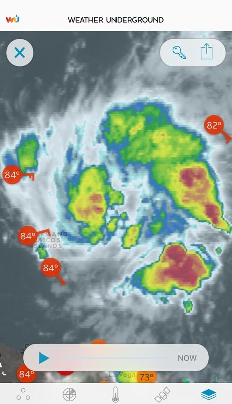
NDG wrote:I must add that surface pressures have not fallen across the Turks & Caicos Islands during the past 24 hrs, pressures are high near 1015mb.
Well the center of low pressure would be east of there so the Turks and Caicos would have relative high pressures
The posts in this forum are NOT official forecast and should not be used as such. They are just the opinion of the poster and may or may not be backed by sound meteorological data. They are NOT endorsed by any professional institution or storm2k.org. For official information, please refer to the NHC and NWS products.
0 likes
-
AutoPenalti
- Category 5
- Posts: 4091
- Age: 29
- Joined: Mon Aug 17, 2015 4:16 pm
- Location: Ft. Lauderdale, Florida
It looks to have weakened considerably.
0 likes
The posts in this forum are NOT official forecasts and should not be used as such. They are just the opinion of the poster and may or may not be backed by sound meteorological data. They are NOT endorsed by any professional institution or STORM2K. For official information, please refer to products from the NHC and NWS.
Model Runs Cheat Sheet:
GFS (5:30 AM/PM, 11:30 AM/PM)
HWRF, GFDL, UKMET, NAVGEM (6:30-8:00 AM/PM, 12:30-2:00 AM/PM)
ECMWF (1:45 AM/PM)
TCVN is a weighted averaged
Who is online
Users browsing this forum: No registered users and 51 guests