ATL: BILL - Post-Tropical
Moderator: S2k Moderators


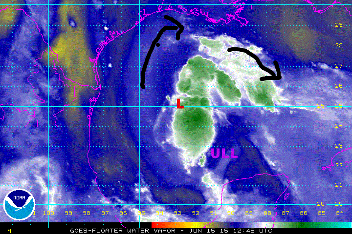
Re: ATL: INVEST 91L - Discussion
I agree with the COC being a little further north and east than where the 12z models were initialized.
0 likes
-
cycloneye

- Admin

- Posts: 149275
- Age: 69
- Joined: Thu Oct 10, 2002 10:54 am
- Location: San Juan, Puerto Rico
Re: ATL: INVEST 91L - Discussion
Those Tropical Force winds are well east and NE of the closed LLC. More stronger.
Peak 10-second Wind: 47 kt at 171°
Peak 10-second Wind: 47 kt at 171°
0 likes
Visit the Caribbean-Central America Weather Thread where you can find at first post web cams,radars
and observations from Caribbean basin members Click Here
and observations from Caribbean basin members Click Here
-
cycloneye
- Admin
- Posts: 149275
- Age: 69
- Joined: Thu Oct 10, 2002 10:54 am
- Location: San Juan, Puerto Rico
Re: ATL: INVEST 91L - Discussion
Set full of TS force winds.Some are contaminated but the majority are legit.When they upgrade may skip TD status.
AF301 02BBA INVEST HDOB 24 20150615
131900 2533N 09131W 9749 00303 0093 +222 //// 172044 048 039 005 01
131930 2532N 09130W 9753 00298 0094 +218 //// 173049 051 040 006 01
132000 2532N 09128W 9754 00301 //// +217 //// 176048 050 041 003 05
132030 2531N 09127W 9754 00301 0097 +217 //// 175050 054 041 002 01
132100 2531N 09126W 9749 00307 0097 +218 +217 175049 052 041 003 01
132130 2530N 09125W 9750 00306 0098 +220 //// 177049 051 040 003 01
132200 2530N 09123W 9747 00310 0098 +221 +215 181047 051 039 001 01
132230 2529N 09122W 9754 00304 0099 +222 +219 185048 050 038 004 00
132300 2528N 09121W 9751 00308 0102 +219 +219 187047 048 038 007 00
132330 2528N 09119W 9750 00308 0104 +219 +219 185042 047 038 013 00
132400 2527N 09118W 9757 00303 0106 +218 +218 183043 045 043 012 00
132430 2526N 09117W 9754 00305 0105 +216 //// 185043 045 047 012 05
132500 2526N 09115W 9748 00312 0103 +224 //// 181043 045 039 006 05
132530 2525N 09114W 9749 00311 0103 +225 //// 181037 039 034 005 01
132600 2524N 09113W 9753 00308 0101 +231 //// 174041 043 031 002 01
132630 2524N 09111W 9746 00313 0102 +237 +230 174043 045 031 001 00
132700 2523N 09110W 9752 00308 0102 +240 +229 173044 045 034 002 03
132730 2522N 09110W 9747 00314 0102 +240 +230 173042 045 032 003 00
132800 2521N 09109W 9754 00309 0103 +243 +230 172040 041 037 003 00
132830 2520N 09108W 9751 00313 0104 +244 +226 171043 045 037 004 00
0 likes
Visit the Caribbean-Central America Weather Thread where you can find at first post web cams,radars
and observations from Caribbean basin members Click Here
and observations from Caribbean basin members Click Here
-
Hurricaneman

- Category 5

- Posts: 7404
- Age: 45
- Joined: Tue Aug 31, 2004 3:24 pm
- Location: central florida
Id go 40kt first advisory
The posts in this forum are NOT official forecast and should not be used as such. They are just the opinion of the poster and may or may not be backed by sound meteorological data. They are NOT endorsed by any professional institution or storm2k.org. For official information, please refer to the NHC and NWS products
The posts in this forum are NOT official forecast and should not be used as such. They are just the opinion of the poster and may or may not be backed by sound meteorological data. They are NOT endorsed by any professional institution or storm2k.org. For official information, please refer to the NHC and NWS products
0 likes
-
Extratropical94

- Professional-Met

- Posts: 3545
- Age: 31
- Joined: Wed Oct 20, 2010 6:36 am
- Location: Hamburg, Germany
- Contact:
An overview of the mission into 91L so far.

0 likes
54° 11' 59'' N, 9° 9' 20'' E
Boomer Sooner!
Go Broncos! Go Cards!
Clinching counties, one at a time: https://mob-rule.com/user-gifs/USA/xtrp94.gif
- Daniel
Boomer Sooner!
Go Broncos! Go Cards!
Clinching counties, one at a time: https://mob-rule.com/user-gifs/USA/xtrp94.gif
- Daniel
-
cycloneye
- Admin
- Posts: 149275
- Age: 69
- Joined: Thu Oct 10, 2002 10:54 am
- Location: San Juan, Puerto Rico
Re:
Hurricaneman wrote:Id go 40kt first advisory
The posts in this forum are NOT official forecast and should not be used as such. They are just the opinion of the poster and may or may not be backed by sound meteorological data. They are NOT endorsed by any professional institution or storm2k.org. For official information, please refer to the NHC and NWS products
There it is. Updated 12z Best Track:
91L INVEST 150615 1200 24.5N 93.0W ATL 40 1006
0 likes
Visit the Caribbean-Central America Weather Thread where you can find at first post web cams,radars
and observations from Caribbean basin members Click Here
and observations from Caribbean basin members Click Here

-
tolakram
- Admin
- Posts: 20179
- Age: 62
- Joined: Sun Aug 27, 2006 8:23 pm
- Location: Florence, KY (name is Mark)
Re: ATL: INVEST 91L - Discussion
15 frame visible, speed up to help show the motion.
http://wwwghcc.msfc.nasa.gov/cgi-bin/get-goes?satellite=GOES-E%20CONUS&lat=26&lon=-94&info=vis&zoom=1&width=1000&height=800&quality=92&type=Animation&palette=ir1.pal&mapcolor=gray&numframes=15
http://wwwghcc.msfc.nasa.gov/cgi-bin/get-goes?satellite=GOES-E%20CONUS&lat=26&lon=-94&info=vis&zoom=1&width=1000&height=800&quality=92&type=Animation&palette=ir1.pal&mapcolor=gray&numframes=15
0 likes
M a r k
- - - - -
Join us in chat: Storm2K Chatroom Invite. Android and IOS apps also available.
The posts in this forum are NOT official forecasts and should not be used as such. Posts are NOT endorsed by any professional institution or STORM2K.org. For official information and forecasts, please refer to NHC and NWS products.

Re: ATL: INVEST 91L - Discussion
Recon just found a rather well-defined, though weak wind shift near 25.1 N, 92.8 W (of course some margin of error in a developing system like this).
Great map of winds in Invest 91L: http://www.tropicaltidbits.com/recon/
Definitely looks to be organizing.
Great map of winds in Invest 91L: http://www.tropicaltidbits.com/recon/
Definitely looks to be organizing.
0 likes
-
SouthDadeFish

- Professional-Met
- Posts: 2835
- Joined: Thu Sep 23, 2010 2:54 pm
- Location: Miami, FL
- Contact:
Re: ATL: INVEST 91L - Discussion
BigA wrote:Recon just found a rather well-defined, though weak wind shift near 25.1 N, 92.8 W (of course some margin of error in a developing system like this).
Great map of winds in Invest 91L: http://www.tropicaltidbits.com/recon/
Definitely looks to be organizing.
Agreed. In the past six hours, this invest has gone from this:

To this:

0 likes
-
tropicwatch

- Category 5
- Posts: 3426
- Age: 62
- Joined: Sat Jun 02, 2007 10:01 am
- Location: Panama City Florida
- Contact:
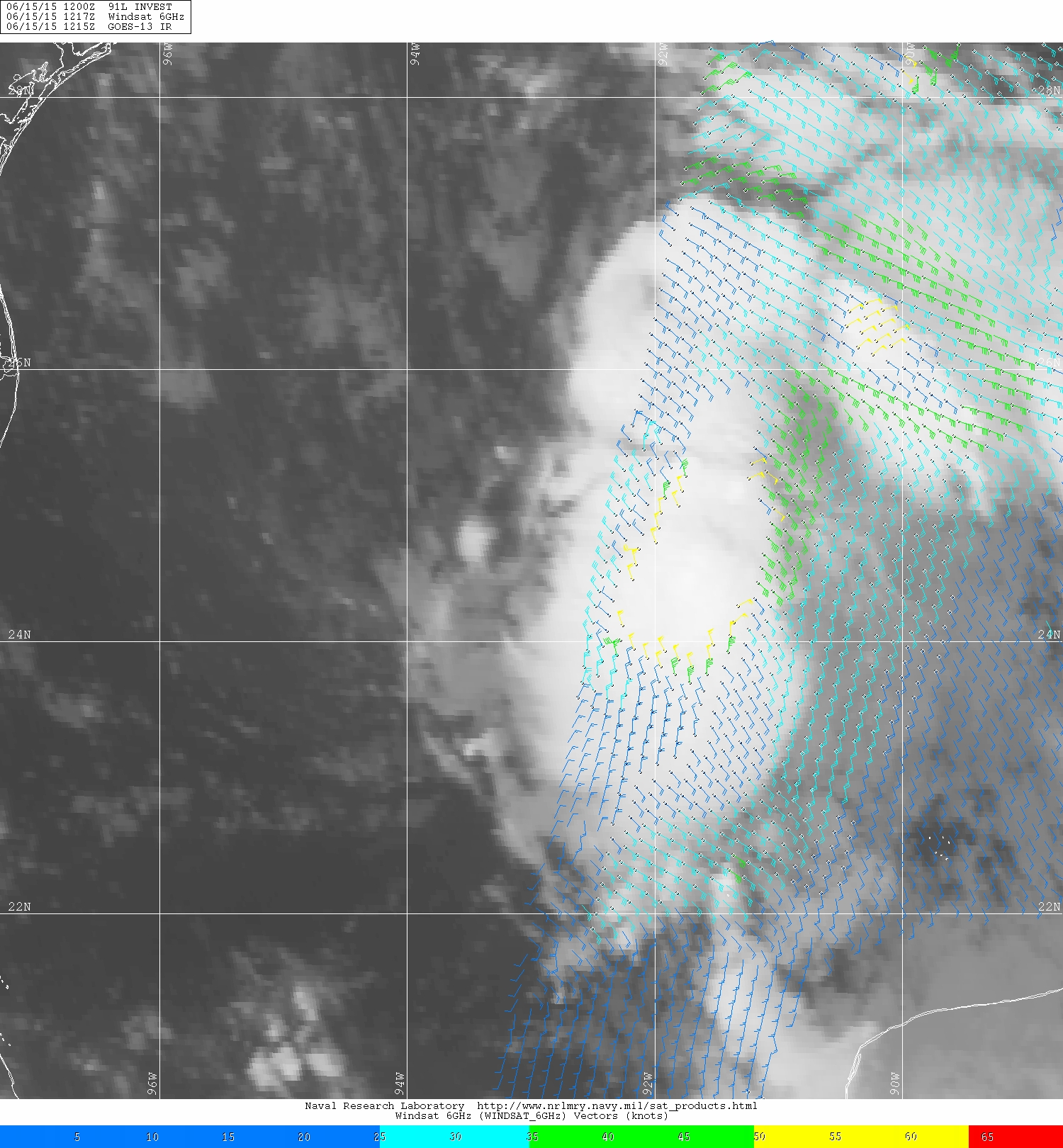
Don't think I have seen it posted but here is the windsat:
0 likes
Tropicwatch
Agnes 72', Eloise 75, Elena 85', Kate 85', Charley 86', Florence 88', Beryl 94', Dean 95', Erin 95', Opal 95', Earl 98', Georges 98', Ivan 2004', Arlene 2005', Dennis 2005', Ida 2009' Debby 2012' Irma 2017' Michael 2018'
Agnes 72', Eloise 75, Elena 85', Kate 85', Charley 86', Florence 88', Beryl 94', Dean 95', Erin 95', Opal 95', Earl 98', Georges 98', Ivan 2004', Arlene 2005', Dennis 2005', Ida 2009' Debby 2012' Irma 2017' Michael 2018'
Re: ATL: INVEST 91L - Discussion
Recon just found a rather well-defined, though weak wind shift near 25.1 N, 92.8 W (of course some margin of error in a developing system like this).
Great map of winds in Invest 91L: http://www.tropicaltidbits.com/recon/
Definitely looks to be organizing.
Great map of winds in Invest 91L: http://www.tropicaltidbits.com/recon/
Definitely looks to be organizing.
0 likes

Re: ATL: INVEST 91L - Discussion
BigA wrote:Recon just found a rather well-defined, though weak wind shift near 25.1 N, 92.8 W (of course some margin of error in a developing system like this).
Great map of winds in Invest 91L: http://www.tropicaltidbits.com/recon/
Definitely looks to be organizing.
Do you think we'll get a special advisory upgrade this afternoon or will they wait until 5pm?
0 likes
The above post is not official and should not be used as such. It is the opinion of the poster and may or may not be backed by sound meteorological data. It is not endorsed by any professional institution or storm2k.org. For official information, please refer to the NHC and NWS products.
-
Hurricaneman
- Category 5
- Posts: 7404
- Age: 45
- Joined: Tue Aug 31, 2004 3:24 pm
- Location: central florida
Re: ATL: INVEST 91L - Discussion
probably waiting for a vortex message before pulling the trigger
The posts in this forum are NOT official forecast and should not be used as such. They are just the opinion of the poster and may or may not be backed by sound meteorological data. They are NOT endorsed by any professional institution or storm2k.org. For official information, please refer to the NHC and NWS products
The posts in this forum are NOT official forecast and should not be used as such. They are just the opinion of the poster and may or may not be backed by sound meteorological data. They are NOT endorsed by any professional institution or storm2k.org. For official information, please refer to the NHC and NWS products
0 likes
Who is online
Users browsing this forum: No registered users and 128 guests