ATL: JOAQUIN - Post-Tropical - Discussion
Moderator: S2k Moderators
-
hurricanedude

- Military Member

- Posts: 1856
- Joined: Tue Oct 08, 2002 9:54 am
- Location: Virginia Beach, Virginia
- Contact:
Re: ATL: ELEVEN - Tropical Depression - Discussion
abajan report me if you want......no one else has a problem with me..if you do...so be it
0 likes


Re: ATL: ELEVEN - Tropical Depression - Discussion
Shortwave still shows close to as much detail as visible.
0 likes

-
gatorcane

- S2K Supporter

- Posts: 23708
- Age: 48
- Joined: Sun Mar 13, 2005 3:54 pm
- Location: Boca Raton, FL
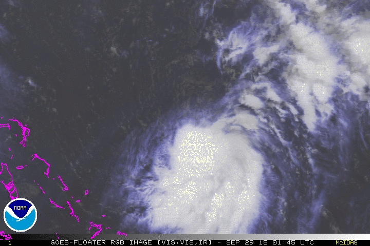
Every frame that comes in shows deeper convection and the convection expanding. There are some extremely cold cloud tops showing up now. I do not know why RECON would be cancelled tomorrow.
Looks at the yellow showing up now on this IR image. When was the last time we saw that with a tropical system in this part of the Atlantic?

Looks at the yellow showing up now on this IR image. When was the last time we saw that with a tropical system in this part of the Atlantic?
0 likes
-
tatertawt24
- Category 1

- Posts: 309
- Joined: Wed Oct 24, 2012 12:57 pm
Can recon reschedule if they see fit?
0 likes
Personal Forecast Disclaimer:
The posts in this forum are NOT official forecast and should not be used as such. They are just the opinion of the poster and may or may not be backed by sound meteorological data. They are NOT endorsed by any professional institution or storm2k.org. For official information, please refer to the NHC and NWS products.
The posts in this forum are NOT official forecast and should not be used as such. They are just the opinion of the poster and may or may not be backed by sound meteorological data. They are NOT endorsed by any professional institution or storm2k.org. For official information, please refer to the NHC and NWS products.
Re: ATL: ELEVEN - Tropical Depression - Discussion
Gator,
Do you think FL is still pretty much in the clear or do you think that has changed?
Do you think FL is still pretty much in the clear or do you think that has changed?
0 likes
Personal Forecast Disclaimer:
The posts in this forum are NOT official forecasts and should not be used as such. They are just the opinion of the poster and may or may not be backed by sound meteorological data. They are NOT endorsed by any professional institution or storm2k.org. For official information, please refer to the NHC and NWS products.
The posts in this forum are NOT official forecasts and should not be used as such. They are just the opinion of the poster and may or may not be backed by sound meteorological data. They are NOT endorsed by any professional institution or storm2k.org. For official information, please refer to the NHC and NWS products.
-
johngaltfla

- Category 5

- Posts: 2073
- Joined: Sun Jul 10, 2005 9:17 pm
- Location: Sarasota County, FL
- Contact:
Re:
Alyono wrote:I'd like to know why recon was cancelled for tomorrow
That is disturbing based on the latest satellite imagery.
0 likes
-
ozonepete
- Professional-Met

- Posts: 4743
- Joined: Mon Sep 07, 2009 3:23 pm
- Location: From Ozone Park, NYC / Now in Brooklyn, NY
Re:
tatertawt24 wrote:Can recon reschedule if they see fit?
Yes, for sure, although they need some lead time. I'm puzzled why it was cancelled as well. It's possible they feel they can rely on Dvorak, satellite images and ASCAT to upgrade tomorrow and thus save missions for Wednesday and beyond. They may need a lot of missions after that if the east coast is threatened.
0 likes


Re: Re:
Shortwave IR shows another vortex is about to be spit out to the north.
Slower shorter term intensification (as well as the movement seeming to be significantly slower) could be another reason for the cancellation.
ozonepete wrote:tatertawt24 wrote:Can recon reschedule if they see fit?
Yes, for sure, although they need some lead time. I'm puzzled why it was cancelled as well. It's possible they feel they can rely on Dvorak, satellite images and ASCAT to upgrade tomorrow and thus save missions for Wednesday and beyond. They may need a lot of missions after that if the east coast is threatened.
Slower shorter term intensification (as well as the movement seeming to be significantly slower) could be another reason for the cancellation.
0 likes
The above post is not official and should not be used as such. It is the opinion of the poster and may or may not be backed by sound meteorological data. It is not endorsed by any professional institution or storm2k.org. For official information, please refer to the NHC and NWS products.
-
TheStormExpert
New Video Discussion from Tropical Tidbits Levi Cowan.
@TropicalTidbits: I've posted a video discussion on Invest 99L and Tropical Depression 11:
http://t.co/M4cW7AUwYP
0 likes
-
1900hurricane

- Category 5
- Posts: 6063
- Age: 34
- Joined: Fri Feb 06, 2015 12:04 pm
- Location: Houston, TX
- Contact:
Equatorial outflow is actually quite good for what 11L is right now. That's probably a big reason why the convection is fairly healthy, despite the shear.
0 likes
Contract Meteorologist. TAMU & MSST. Fiercely authentic, one of a kind. We are all given free will, so choose a life meant to be lived. We are the Masters of our own Stories.
Opinions expressed are mine alone.
Follow me on Twitter at @1900hurricane : Read blogs at https://1900hurricane.wordpress.com/
Opinions expressed are mine alone.
Follow me on Twitter at @1900hurricane : Read blogs at https://1900hurricane.wordpress.com/
Latest ASCAT pass 25kts est- in there-
http://manati.star.nesdis.noaa.gov/asca ... MBds87.png
http://manati.star.nesdis.noaa.gov/data ... TData.php/

nrl image
http://www.nrlmry.navy.mil/htdocs_dyn_p ... .100pc.jpg
http://manati.star.nesdis.noaa.gov/asca ... MBds87.png
http://manati.star.nesdis.noaa.gov/data ... TData.php/
nrl image
http://www.nrlmry.navy.mil/htdocs_dyn_p ... .100pc.jpg
0 likes

LLC is clearly on the northern edge of the convection, not quite underneath of the middle of it. Light to moderate northerly shear is still affecting it, IMO, convection is having a hard time expanding to the north.
http://wwwghcc.msfc.nasa.gov/cgi-bin/ge ... mframes=30
http://wwwghcc.msfc.nasa.gov/cgi-bin/ge ... mframes=30
0 likes
Re:
TJRE wrote:Latest ASCAT pass 25kts est- in there-
http://manati.star.nesdis.noaa.gov/asca ... MBds87.png
http://manati.star.nesdis.noaa.gov/data ... TData.php/
nrl image
http://www.nrlmry.navy.mil/htdocs_dyn_p ... .100pc.jpg
The image above is from 14z this morning, the LLC is now close 26N after moving S all day.
0 likes
-
TropicalAnalystwx13

- Category 5
- Posts: 2109
- Age: 28
- Joined: Tue Jul 19, 2011 8:20 pm
- Location: Wilmington, NC
- Contact:
Re:
TJRE wrote:Latest ASCAT pass 25kts est- in there-
http://manati.star.nesdis.noaa.gov/asca ... MBds87.png
http://manati.star.nesdis.noaa.gov/data ... TData.php/
nrl image
http://www.nrlmry.navy.mil/htdocs_dyn_p ... .100pc.jpg
That ASCAT pass is from 10am EDT this morning (pass time is the purple time stamp at the bottom of the image)
0 likes
Re:
NDG wrote:LLC is clearly on the northern edge of the convection, not quite underneath of the middle of it. Light to moderate northerly shear is still affecting it, IMO, convection is having a hard time expanding to the north.
http://wwwghcc.msfc.nasa.gov/cgi-bin/ge ... mframes=30
Latest microwave pass shows this as well, though that's a fairly solid area of convection to the south.

I can easily see this being a TS at the moment barring ASCAT showing otherwise.
0 likes
The above post is not official and should not be used as such. It is the opinion of the poster and may or may not be backed by sound meteorological data. It is not endorsed by any professional institution or storm2k.org. For official information, please refer to the NHC and NWS products.
-
ozonepete
- Professional-Met
- Posts: 4743
- Joined: Mon Sep 07, 2009 3:23 pm
- Location: From Ozone Park, NYC / Now in Brooklyn, NY
Re:
1900hurricane wrote:Equatorial outflow is actually quite good for what 11L is right now. That's probably a big reason why the convection is fairly healthy, despite the shear.
Good point. And good outflow is now clearly developing on the southwest quadrant.
0 likes
-
ozonepete
- Professional-Met
- Posts: 4743
- Joined: Mon Sep 07, 2009 3:23 pm
- Location: From Ozone Park, NYC / Now in Brooklyn, NY
Re: ATL: ELEVEN - Tropical Depression - Discussion
It's got the look again. Building a nice core over the LLC. Let's see if it holds and/or expands more symmetrically overnight. Those are really cold cloud tops / hot towers popping now.

0 likes
-
HurricaneBelle

- S2K Supporter
- Posts: 1209
- Joined: Sun Aug 27, 2006 6:12 pm
- Location: Clearwater, FL
Re: ATL: ELEVEN - Tropical Depression - Discussion
Say hello to Joaquin:
WTNT31 KNHC 290236
TCPAT1
BULLETIN
TROPICAL STORM JOAQUIN ADVISORY NUMBER 5
NWS NATIONAL HURRICANE CENTER MIAMI FL AL112015
1100 PM EDT MON SEP 28 2015
...DEPRESSION STRENGTHENS TO TROPICAL STORM JOAQUIN...
...THE TENTH NAMED STORM OF THE SEASON...
SUMMARY OF 1100 PM EDT...0300 UTC...INFORMATION
-----------------------------------------------
LOCATION...26.7N 70.4W
ABOUT 400 MI...645 KM NE OF THE CENTRAL BAHAMAS
MAXIMUM SUSTAINED WINDS...40 MPH...65 KM/H
PRESENT MOVEMENT...SW OR 230 DEGREES AT 5 MPH...7 KM/H
MINIMUM CENTRAL PRESSURE...1002 MB...29.59 INCHES
WATCHES AND WARNINGS
--------------------
There are no coastal watches or warnings in effect.
0 likes
Who is online
Users browsing this forum: No registered users and 82 guests