ATL: ERIKA - Remnants - Discussion

Moderator: S2k Moderators

Message
Author
BobHarlem
Category 5
Category 5
Posts: 2108
Joined: Thu Oct 20, 2005 6:11 pm

Re: ATL: ERIKA - Tropical Storm - Discussion

#2781 Postby BobHarlem » Fri Aug 28, 2015 10:14 pm

Jevo wrote:We used to joke around that Avilia would write an 11pm disco and Stewart would come in at 5am and just be like "Ok everything that guy said at 11pm is crap, here's whats going on"


Yeah Avila has gotten the reputation of being very conservative and reluctant to mention new developments until they were proven over time. The NHC in general is very careful about the forecasts, so its understandable. This may be happening again. But time will tell.
0 likes   

psyclone
S2K Supporter
S2K Supporter
Posts: 4762
Joined: Wed Aug 24, 2005 9:04 pm
Location: palm harbor fl

Re: ATL: ERIKA - Tropical Storm - Discussion

#2782 Postby psyclone » Fri Aug 28, 2015 10:14 pm

CronkPSU wrote:
Bocadude85 wrote:With the track now over Cuba why haven't the TS warnings for the central Bahamas and the watches for the northwest Bahamas been dropped?


Lol good point, so South Florida not in the cone but islands further north and east are?


important to remember the cone is the track of the center so as a storm closes in more and more inclement weather will reside outside the cone. this is why warnings stretch well beyond the cone as a storm nears landfall. nonetheless your point about watches/warnings for the Bahamas being no longer necessary is valid.
0 likes   

User avatar
blp
Category 5
Category 5
Posts: 2840
Age: 46
Joined: Thu Sep 09, 2004 7:51 pm
Location: Miami, FL
Contact:

Re: ATL: ERIKA - Tropical Storm - Discussion

#2783 Postby blp » Fri Aug 28, 2015 10:15 pm

From Dr Masters.

A personal weather station in Barahona, Dominican Republic, has recorded 16.13" of rain between 1 pm and 10 pm, including 8.80" in one hour from 8 pm to 9 pm:

http://www.wunderground.com/personal-weather-stat ion/dashboard?ID=IBARAHON3

Rainfall at that level is going to cause extreme flooding, though it is possible the measurement was bad.

Dr. M.
0 likes   
The following post is NOT an official forecast and should not be used as such. It is just the opinion of the poster and may or may not be backed by sound meteorological data. It is NOT endorsed by any professional institution including storm2k.org For Official Information please refer to the NHC and NWS products.

ozonepete
Professional-Met
Professional-Met
Posts: 4743
Joined: Mon Sep 07, 2009 3:23 pm
Location: From Ozone Park, NYC / Now in Brooklyn, NY

Re:

#2784 Postby ozonepete » Fri Aug 28, 2015 10:20 pm

galaxy401 wrote:The new NHC discussion didn't mention the microwave images. It might be just an illusion.


Very interesting to me that they didn't. I wonder why, but I will find out...
0 likes   

ozonepete
Professional-Met
Professional-Met
Posts: 4743
Joined: Mon Sep 07, 2009 3:23 pm
Location: From Ozone Park, NYC / Now in Brooklyn, NY

Re:

#2785 Postby ozonepete » Fri Aug 28, 2015 10:23 pm

psyclone wrote:You can bet if that microwave imagery was legit organization the NHC would have mentioned it.


It is absolutely "legit." Microwave satellite images either come through correctly or are declared contaminated and not shown. So it has nothing to do with that. They saw the images and decided not to include them in the discussion. Unusual but not unheard of with them. Quite likely they needed more time to understand what those images are telling us.
0 likes   

psyclone
S2K Supporter
S2K Supporter
Posts: 4762
Joined: Wed Aug 24, 2005 9:04 pm
Location: palm harbor fl

Re: Re:

#2786 Postby psyclone » Fri Aug 28, 2015 10:31 pm

ozonepete wrote:
psyclone wrote:You can bet if that microwave imagery was legit organization the NHC would have mentioned it.


It is absolutely "legit." Microwave satellite images either come through correctly or are declared contaminated and not shown. So it has nothing to do with that. They saw the images and decided not to include them in the discussion. Unusual but not unheard of with them. Quite likely they needed more time to understand what those images are telling us.


yeah but what are they showing? something meaningful development-wise or something random that looks ominous? I don't know but if it were rapid development I can't imagine it wouldn't be discussed/at least mentioned.
0 likes   

User avatar
thundercam96
Tropical Storm
Tropical Storm
Posts: 129
Joined: Thu Aug 18, 2011 3:01 pm
Location: Boston, MA

Re:

#2787 Postby thundercam96 » Fri Aug 28, 2015 10:33 pm

AdamFirst wrote:my RA for my dorm at FIU just visited us and confirmed our hurricane evacuation plans (just in case)


I'm a freshman @ Embry-Riddle Aeronautical University in Daytona Beach, and they came by last night to do the same. I'm not sure what the threshold is for evacuating the school. Embry-Riddle is known for their flight program, and word is they are preparing to fly the fleet of aircraft to GA.
0 likes   
Fay '08 / Mathew 16'

Personal Forecast Disclaimer: I am not a certified meteorologist, therefore, what is posted on this forum under my header should not be treated as an official forecast. Please refer to the NWS/NHC products for forecast information.

psyclone
S2K Supporter
S2K Supporter
Posts: 4762
Joined: Wed Aug 24, 2005 9:04 pm
Location: palm harbor fl

Re: Re:

#2788 Postby psyclone » Fri Aug 28, 2015 10:42 pm

thundercam96 wrote:
AdamFirst wrote:my RA for my dorm at FIU just visited us and confirmed our hurricane evacuation plans (just in case)


I'm a freshman @ Embry-Riddle Aeronautical University in Daytona Beach, and they came by last night to do the same. I'm not sure what the threshold is for evacuating the school. Embry-Riddle is known for their flight program, and word is they are preparing to fly the fleet of aircraft to GA.


I would imagine that process was contemplated when Erika was forecast to ride up the east coast as a hurricane.
0 likes   

User avatar
Bocadude85
Category 5
Category 5
Posts: 2991
Age: 38
Joined: Mon Apr 18, 2005 2:20 pm
Location: Honolulu,Hi

Re: ATL: ERIKA - Tropical Storm - Discussion

#2789 Postby Bocadude85 » Fri Aug 28, 2015 10:43 pm

Looking at IR I do not see how Erika doesn't move over eastern Cuba
0 likes   

ozonepete
Professional-Met
Professional-Met
Posts: 4743
Joined: Mon Sep 07, 2009 3:23 pm
Location: From Ozone Park, NYC / Now in Brooklyn, NY

Re: Re:

#2790 Postby ozonepete » Fri Aug 28, 2015 10:46 pm

psyclone wrote:
ozonepete wrote:
psyclone wrote:You can bet if that microwave imagery was legit organization the NHC would have mentioned it.


It is absolutely "legit." Microwave satellite images either come through correctly or are declared contaminated and not shown. So it has nothing to do with that. They saw the images and decided not to include them in the discussion. Unusual but not unheard of with them. Quite likely they needed more time to understand what those images are telling us.


yeah but what are they showing? something meaningful development-wise or something random that looks ominous? I don't know but if it were rapid development I can't imagine it wouldn't be discussed/at least mentioned.


Definitely not random. And definitely not rapid intensification. You can have an eye start to develop at the md-levels in a weak TC and it could take days to become dominant all the way down to the surface and up to 300 mb. So it does not necessarily imply RI at all, ok? You've been around here long enough that I think that makes sense to you, right my friend? There is clearly a mid level circulation closing off an eye-like feature there, but the same way I and our other mets really can't explain this easily or quickly, I'm sure the NHC guys are not sure what to make of it either. I'll bet they are all still looking at it now and discussing what's going on. Analyzing microwave sat images is still a very new branch of hurricane analysis and forecasting. And I would want to see more mw sat images before making any conclusions.
0 likes   

User avatar
Hurricaneman
Category 5
Category 5
Posts: 7351
Age: 45
Joined: Tue Aug 31, 2004 3:24 pm
Location: central florida

Re: ATL: ERIKA - Tropical Storm - Discussion

#2791 Postby Hurricaneman » Fri Aug 28, 2015 10:50 pm

Could be a temporary feature on the MW images

The posts in this forum are NOT official forecast and should not be used as such. They are just the opinion of the poster and may or may not be backed by sound meteorological data. They are NOT endorsed by any professional institution or storm2k.org. For official information, please refer to the NHC and NWS products
0 likes   

psyclone
S2K Supporter
S2K Supporter
Posts: 4762
Joined: Wed Aug 24, 2005 9:04 pm
Location: palm harbor fl

Re: ATL: ERIKA - Tropical Storm - Discussion

#2792 Postby psyclone » Fri Aug 28, 2015 10:53 pm

Hurricaneman wrote:Could be a temporary feature on the MW images

The posts in this forum are NOT official forecast and should not be used as such. They are just the opinion of the poster and may or may not be backed by sound meteorological data. They are NOT endorsed by any professional institution or storm2k.org. For official information, please refer to the NHC and NWS products


Do you know when we will get a new one?
0 likes   

User avatar
Hurricaneman
Category 5
Category 5
Posts: 7351
Age: 45
Joined: Tue Aug 31, 2004 3:24 pm
Location: central florida

Re: ATL: ERIKA - Tropical Storm - Discussion

#2793 Postby Hurricaneman » Fri Aug 28, 2015 10:55 pm

psyclone wrote:
Hurricaneman wrote:Could be a temporary feature on the MW images

The posts in this forum are NOT official forecast and should not be used as such. They are just the opinion of the poster and may or may not be backed by sound meteorological data. They are NOT endorsed by any professional institution or storm2k.org. For official information, please refer to the NHC and NWS products


Do you know when we will get a new one?


Sometime in the morning I think
0 likes   

emeraldislenc
Category 2
Category 2
Posts: 559
Joined: Fri Aug 24, 2012 4:49 pm
Location: Emerald Isle NC

#2794 Postby emeraldislenc » Fri Aug 28, 2015 10:57 pm

It looks better now than in the past 24 hours!
0 likes   

User avatar
Bocadude85
Category 5
Category 5
Posts: 2991
Age: 38
Joined: Mon Apr 18, 2005 2:20 pm
Location: Honolulu,Hi

Re:

#2795 Postby Bocadude85 » Fri Aug 28, 2015 10:58 pm

spiral wrote:The MW +wind data indicated a 50+ TS.


What wind data are you referring to? I haven't seen any gusts higher then 40 mph reported in Hispaniola
0 likes   

Chris_in_Tampa
Category 5
Category 5
Posts: 5075
Age: 41
Joined: Thu Jun 21, 2007 11:06 pm
Location: Tampa, Florida, USA
Contact:

#2796 Postby Chris_in_Tampa » Fri Aug 28, 2015 11:07 pm

Radar, mostly for later, though appearing some now.

Guantanamo Bay Short Range:
http://radar.weather.gov/ridge/radar_li ... R&loop=yes

Cuba, when working:
http://www.insmet.cu/asp/genesis.asp?TB ... B1=RADARES
It was not working earlier.
0 likes   

emeraldislenc
Category 2
Category 2
Posts: 559
Joined: Fri Aug 24, 2012 4:49 pm
Location: Emerald Isle NC

Re: ATL: ERIKA - Tropical Storm - Discussion

#2797 Postby emeraldislenc » Fri Aug 28, 2015 11:14 pm

I meant appearance :flag:
0 likes   

User avatar
rolltide
Tropical Storm
Tropical Storm
Posts: 234
Age: 65
Joined: Thu Sep 09, 2004 5:33 pm
Location: Pensacola Florida

Re: ATL: ERIKA - Tropical Storm - Discussion

#2798 Postby rolltide » Fri Aug 28, 2015 11:17 pm

Tomorrow should be interesting (I'm in central time so it's still friday) This has been a fun storm to track. It keeps throwing us curve balls that defies the models and the NHC. Best storm to track in years.


The posts in this forum are NOT official forecast and should not be used as such. They are just the opinion of the poster and may or may not be backed by sound meteorological data. They are NOT endorsed by any professional institution or storm2k.org. For official information, please refer to the NHC and NWS products.
0 likes   

ozonepete
Professional-Met
Professional-Met
Posts: 4743
Joined: Mon Sep 07, 2009 3:23 pm
Location: From Ozone Park, NYC / Now in Brooklyn, NY

Re: ATL: ERIKA - Tropical Storm - Discussion

#2799 Postby ozonepete » Fri Aug 28, 2015 11:21 pm

Hurricaneman wrote:
psyclone wrote:
Hurricaneman wrote:Could be a temporary feature on the MW images

The posts in this forum are NOT official forecast and should not be used as such. They are just the opinion of the poster and may or may not be backed by sound meteorological data. They are NOT endorsed by any professional institution or storm2k.org. For official information, please refer to the NHC and NWS products


Do you know when we will get a new one?


Sometime in the morning I think


Go to the NAVY site:
http://www.nrlmry.navy.mil/tc-bin/tc_ho ... &TYPE=ssmi


then click on Erika under Atlantic in the upper left.
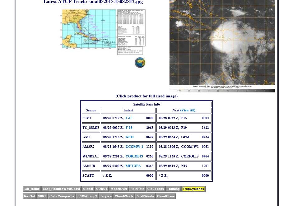
then scroll down to the lower part of the panel and you will see the list of most recent microwave images taken (look at a screen copy below here) and on the right side when the next one will be taken.
you can see for Erika the TC_SSMIS 08/29 0017 image we were talking about has a next image to be taken at 1622 UTC which isn't until tomorrow 12:22 EDT.

NOTE: Forget the 0502. That was from 08/28 or last night. Nothing good for the time being. Rats.

Image
Last edited by ozonepete on Fri Aug 28, 2015 11:29 pm, edited 2 times in total.
0 likes   

User avatar
Ntxw
Storm2k Moderator
Storm2k Moderator
Posts: 22785
Joined: Wed Oct 21, 2009 6:34 pm
Location: DFW, Texas

#2800 Postby Ntxw » Fri Aug 28, 2015 11:21 pm

With the animated loops, seems like she is putting out a gust front on the W/SW side. Almost like an MCS/Derecho over land as it bows out and weakens the convection behind it. You can see wind gusts in the range of 50-70mph+ range with those events near the gust fronts.

Image
0 likes   
The above post and any post by Ntxw is NOT an official forecast and should not be used as such. It is just the opinion of the poster and may or may not be backed by sound meteorological data. It is NOT endorsed by any professional institution including Storm2k. For official information, please refer to NWS products.

  Help support Storm2K!
Help Support Storm2K


Return to “2015”

Who is online

Users browsing this forum: No registered users and 10 guests