ATL: DANNY - Remnants - Discussion
Moderator: S2k Moderators

Re: ATL: DANNY - Tropical Storm - Discussion
Looks like it could become a big sized storm pretty fast.
0 likes
Personal Forecast Disclaimer:
The posts in this forum are NOT official forecast and should not be used as such. They are just the opinion of the poster and may or may not be backed by sound meteorological data. They are NOT endorsed by any professional institution or storm2k.org. For official information, please refer to the NHC and NWS products.
The posts in this forum are NOT official forecast and should not be used as such. They are just the opinion of the poster and may or may not be backed by sound meteorological data. They are NOT endorsed by any professional institution or storm2k.org. For official information, please refer to the NHC and NWS products.
-
latitude_20

- Tropical Storm

- Posts: 196
- Joined: Wed Jun 30, 2010 6:46 am
- Location: Tulum, Mexico
- Contact:
Re: ATL: DANNY - Tropical Storm - Discussion
NDG wrote:I am shaking my head going how in the world will conditions improve almost overnight over the Caribbean after having record breaking windshear all season long so far. Mark my words, Danny will not survive tracking across the Caribbean if indeed it takes that track, better chances of surviving if it tracks north of the islands.
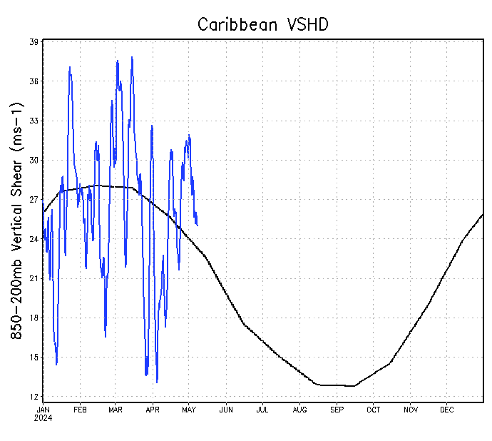
Shear actually looks to be on the decrease.
0 likes

Re: ATL: DANNY - Tropical Storm - Discussion
Should be a lot of heat to fuel this one. Feels good to have a storm to track! Not liking the Cat 2 forecast for the islands though.
0 likes
The following post is NOT an official forecast and should not be used as such. It is just the opinion of the poster and may or may not be backed by sound meteorological data. It is NOT endorsed by any professional institution including storm2k.org For Official Information please refer to the NHC and NWS products.

Re: ATL: DANNY - Tropical Storm - Discussion
latitude_20 wrote:NDG wrote:I am shaking my head going how in the world will conditions improve almost overnight over the Caribbean after having record breaking windshear all season long so far. Mark my words, Danny will not survive tracking across the Caribbean if indeed it takes that track, better chances of surviving if it tracks north of the islands.
http://www.ssd.noaa.gov/PS/TROP/TCFP/da ... r_VSHD.gif
Shear actually looks to be on the decrease.
If you notice carefully is on its way back up after very briefly coming down to near average. There is still plenty of 30 knot wind shear axis across the Caribbean, at some point even if the shear axis east of the islands start pushing west Danny will come across it. Even more damaging to Danny if it gets hit by mid level shear as it starts nearing the Caribbean.
0 likes
-
ozonepete
- Professional-Met

- Posts: 4743
- Joined: Mon Sep 07, 2009 3:23 pm
- Location: From Ozone Park, NYC / Now in Brooklyn, NY
Re: ATL: DANNY - Tropical Storm - Discussion
NDG wrote:latitude_20 wrote:NDG wrote:I am shaking my head going how in the world will conditions improve almost overnight over the Caribbean after having record breaking windshear all season long so far. Mark my words, Danny will not survive tracking across the Caribbean if indeed it takes that track, better chances of surviving if it tracks north of the islands.
http://www.ssd.noaa.gov/PS/TROP/TCFP/da ... r_VSHD.gif
Shear actually looks to be on the decrease.
If you notice carefully is on its way back up after very briefly coming down to near average. There is still plenty of 30 knot wind shear axis across the Caribbean, at some point even if the shear axis east of the islands start pushing west Danny will come across it. Even more damaging to Danny if it gets hit by mid level shear as it starts nearing the Caribbean.
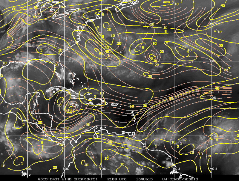
http://i20.photobucket.com/albums/b245/ ... 4kwrgz.gif
Just remember only the shear that is forecast to be there when Danny arrives is important. Additionally shear forecasts are still pretty awful and are often 100% wrong 5 days out. So right now, statistically, there is no reliable forecast of what shear will be there 5 days from now.
0 likes
-
deltadog03

- Professional-Met
- Posts: 3580
- Joined: Tue Jul 05, 2005 6:16 pm
- Location: Macon, GA
Re: Re:
JtSmarts wrote:deltadog03 wrote:Live now on Facebook Live
Hey everyone! We finally have something to track. I am actually a little surprised NHC is so bullish on the strength, but I see the potential this one has. Going to do a Facebook Live update and talk a little bit about it if yall want to watch at around 5:30pm E Self plug yes, sorry
https://www.facebook.com/ChriswxmanSimmons
on twitter as well
https://twitter.com/wxmanchris
Great analysis of Danny's situation today, and your winter comments are music to my ears.
awesome, thank you! I am really excited as we go toward winter. I am still a little surprised NHC is so bullish. I could see how this gets going quickly though. So, I guess they are taking a stance, good for them....
0 likes

Re: ATL: DANNY - Tropical Storm - Discussion
ozonepete wrote:NDG wrote:latitude_20 wrote:
Shear actually looks to be on the decrease.
If you notice carefully is on its way back up after very briefly coming down to near average. There is still plenty of 30 knot wind shear axis across the Caribbean, at some point even if the shear axis east of the islands start pushing west Danny will come across it. Even more damaging to Danny if it gets hit by mid level shear as it starts nearing the Caribbean.
http://i20.photobucket.com/albums/b245/ ... 4kwrgz.gif
Just remember only the shear that is forecast to be there when Danny arrives is important. Additionally shear forecasts are still pretty awful and are often 100% wrong 5 days out. So right now, statistically, there is no reliable forecast of what shear will be there 5 days from now.
But we can go by what has been the usual so far this season, and the usual across the Caribbean has been that windshear has been mostly above average all season long.
0 likes
-
cycloneye

- Admin

- Posts: 149276
- Age: 69
- Joined: Thu Oct 10, 2002 10:54 am
- Location: San Juan, Puerto Rico
Re: ATL: DANNY - Tropical Storm - Discussion
We in Puerto Rico and in some of the Eastern Caribbean islands are going thru a big drought and we will receive with open arms the plenty of rain DANNY will bring but we don't want to deal with a strong Hurricane so we are watching what will transpire.
0 likes
Visit the Caribbean-Central America Weather Thread where you can find at first post web cams,radars
and observations from Caribbean basin members Click Here
and observations from Caribbean basin members Click Here
-
ozonepete
- Professional-Met
- Posts: 4743
- Joined: Mon Sep 07, 2009 3:23 pm
- Location: From Ozone Park, NYC / Now in Brooklyn, NY
Re: ATL: DANNY - Tropical Storm - Discussion
ozonepete wrote:NDG wrote:
Just remember only the shear that is forecast to be there when Danny arrives is important. Additionally shear forecasts are still pretty awful and are often 100% wrong 5 days out. So right now, statistically, there is no reliable forecast of what shear will be there 5 days from now.
But we can go by what has been the usual so far this season, and the usual across the Caribbean has been that windshear has been mostly above average all season long.
Yeah my friend, so that's the climatology-based forecast and that's all we've got until 2 or 3 days from now. The catch of course is that the shear could increase to screaming between now and then or drop to really low values. That's why it's pure speculation right now - the real shear situation 5 days from now is just speculation based on climatology; that's all we got.
0 likes
-
floridasun78
- Category 5

- Posts: 3755
- Joined: Sun May 17, 2009 10:16 pm
- Location: miami fl
Re: ATL: DANNY - Tropical Storm - Discussion
now Atlantic side to be active after pac ocean have it fun
0 likes
Re: ATL: DANNY - Tropical Storm - Discussion
ozonepete wrote:ozonepete wrote:
But we can go by what has been the usual so far this season, and the usual across the Caribbean has been that windshear has been mostly above average all season long.
Yeah my friend, so that's the climatology-based forecast and that's all we've got until 2 or 3 days from now. The catch of course is that the shear could increase to screaming between now and then or drop to really low values. That's why it's pure speculation right now - the real shear situation 5 days from now is just speculation based on climatology; that's all we got.
Maybe Danny will be lucky enough to be the one exception to the rule so far this season across the Caribbean and not come across any destructive windshear, like winning the lottery, one thing I have learned when it comes to the tropics you can never say never
0 likes
-
Gustywind

- Category 5
- Posts: 12334
- Joined: Mon Sep 03, 2007 7:29 am
- Location: Baie-Mahault, GUADELOUPE
Re: ATL: DANNY - Tropical Storm - Discussion
cycloneye wrote:We in Puerto Rico and in some of the Eastern Caribbean islands are going thru a big drought and we will receive with open arms the plenty of rain DANNY will bring but we don't want to deal with a strong Hurricane so we are watching what will transpire.
You're right Cycloneye
But like you said, i can't imagine the EC facing the assault of any hurricanes! That will be a nightmare. Let's hope that nothing bad is pointing at the horizon. By the way, if i've have any infos related to Danny i will keep you informed.
0 likes
-
SouthDadeFish

- Professional-Met
- Posts: 2835
- Joined: Thu Sep 23, 2010 2:54 pm
- Location: Miami, FL
- Contact:

-
NCSTORMMAN
Re:
SouthDadeFish wrote:Danny might be much more organized than we thought:
I want to point out I see some signs of vortex tilt with height, but this is a good start for intensification.
Deep convection has continued to fire over this region of a forming inner core since the time of the microwave pass.
Yeah I said it earlier and I will say it again Danny is going to go over the intensification the NHC has forcasted and now I am worried for us on the southeast/gulf coast from Carolina to Texas after seeing the GFS run. It is not out of the realm of possibilities that Danny is a hurricane by the end of tomorrow. I believe it is undergoing RI as we speak. I could be wrong I am not MET.
Last edited by NCSTORMMAN on Tue Aug 18, 2015 5:57 pm, edited 1 time in total.
0 likes

-
northjaxpro

- S2K Supporter

- Posts: 8900
- Joined: Mon Sep 27, 2010 11:21 am
- Location: Jacksonville, FL
Danny is really ramping up this evening. Very good banding and overall structure. Danny has found a very good environment to really spin.up right now. It sure looks to me we mayhave our first hurricane of this season sooner than anticipated if the current trends I am seeing continues in the short term.
Last edited by northjaxpro on Tue Aug 18, 2015 6:00 pm, edited 1 time in total.
0 likes
NEVER, EVER SAY NEVER in the tropics and weather in general, and most importantly, with life itself!!
________________________________________________________________________________________
Fay 2008 Beryl 2012 Debby 2012 Colin 2016 Hermine 2016 Julia 2016 Matthew 2016 Irma 2017 Dorian 2019
________________________________________________________________________________________
Fay 2008 Beryl 2012 Debby 2012 Colin 2016 Hermine 2016 Julia 2016 Matthew 2016 Irma 2017 Dorian 2019
-
ozonepete
- Professional-Met
- Posts: 4743
- Joined: Mon Sep 07, 2009 3:23 pm
- Location: From Ozone Park, NYC / Now in Brooklyn, NY
Re: Re:
NCSTORMMAN wrote:SouthDadeFish wrote:Danny might be much more organized than we thought:
http://i.imgur.com/HW6T9vB.jpg
I want to point out I see some signs of vortex tilt with height, but this is a good start for intensification.
Deep convection has continued to fire over this region of a forming inner core since the time of the microwave pass.
Yeah I said it earlier and I will say it again Danny is going to go over the intensification the NHC has forcasted and now I am worried for us on the southeast/gulf coast from Carolina to Texas after seeing the GFS run.
Ok my friend so you know the drill. Be vigilant and keep watching here so if a threat develops you can help your friends family and neighbors get through it.
0 likes
-
NCSTORMMAN
Re: Re:
ozonepete wrote:NCSTORMMAN wrote:SouthDadeFish wrote:Danny might be much more organized than we thought:
http://i.imgur.com/HW6T9vB.jpg
I want to point out I see some signs of vortex tilt with height, but this is a good start for intensification.
Deep convection has continued to fire over this region of a forming inner core since the time of the microwave pass.
Yeah I said it earlier and I will say it again Danny is going to go over the intensification the NHC has forcasted and now I am worried for us on the southeast/gulf coast from Carolina to Texas after seeing the GFS run.
Ok my friend so you know the drill. Be vigilant and keep watching here so if a threat develops you can help your friends family and neighbors get through it.
I will just head back to Fayetteville to stay with family during the storm lol. That is the plan anyways but that is a big WHEN a storm hits here. It might not be this one but good to pay attention and I am fascinated by TCs for some reason.
0 likes
Who is online
Users browsing this forum: No registered users and 89 guests