
BULLETIN
HURRICANE JOAQUIN INTERMEDIATE ADVISORY NUMBER 32A
NWS NATIONAL HURRICANE CENTER MIAMI FL AL112015
200 PM AST MON OCT 05 2015
...JOAQUIN MOVING FARTHER AWAY FROM BERMUDA...
...TROPICAL STORM WARNING DISCONTINUED...
SUMMARY OF 200 PM AST...1800 UTC...INFORMATION
----------------------------------------------
LOCATION...35.2N 64.5W
ABOUT 195 MI...315 KM N OF BERMUDA
MAXIMUM SUSTAINED WINDS...85 MPH...140 KM/H
PRESENT MOVEMENT...NNE OR 30 DEGREES AT 13 MPH...20 KM/H
MINIMUM CENTRAL PRESSURE...964 MB...28.47 INCHES
WATCHES AND WARNINGS
--------------------
CHANGES WITH THIS ADVISORY:
The Bermuda Weather Service has discontinued the Tropical Storm
Warning for Bermuda.
SUMMARY OF WATCHES AND WARNINGS IN EFFECT:
There are no coastal watches or warnings in effect.
DISCUSSION AND 48-HOUR OUTLOOK
------------------------------
At 200 PM AST (1800 UTC), the center of Hurricane Joaquin was
located near latitude 35.2 North, longitude 64.5 West. Joaquin is
moving toward the north-northeast near 13 mph (20 km/h), and a turn
toward the northeast is expected later today, followed by a turn
toward the east-northeast on Tuesday. On the forecast track, the
center of Joaquin will continue to move away from Bermuda.
Maximum sustained winds are near 85 mph (140 km/h) with higher
gusts. Gradual weakening is forecast during the next 48 hours,
and Joaquin is expected to transition to a large extratropical low
pressure system on Wednesday.
Hurricane-force winds extend outward up to 35 miles (55 km) from the
center and tropical-storm-force winds extend outward up to 205 miles
(335 km). A sustained wind speed of 37 mph (59 km/h) and a gust to
53 mph (85 km/h) were reported at the Bermuda International Airport
during the past hour.
The estimated minimum central pressure is 964 mb (28.47 inches).
HAZARDS AFFECTING LAND
----------------------
WIND: Tropical-storm-force wind gusts could affect Bermuda for a
few more hours.
STORM SURGE: Water levels near Bermuda should gradually subside
today. Near the coast, the surge will be accompanied by large and
potentially damaging waves.
SURF: Swells generated by Joaquin will continue to affect portions
of the Bahamas during the next day or so. Swells are affecting
much of the east coast of the United States and will spread
northward along the coast of Atlantic Canada during the next day or
two. These swells are likely to cause life-threatening surf and rip
current conditions. Even though Joaquin is passing well east of the
coast of the United States, a prolonged period of elevated water
levels and large waves will affect the mid-Atlantic region, causing
significant beach and dune erosion with moderate coastal flooding
likely. Please consult products from your local weather office.
NEXT ADVISORY
-------------
Next complete advisory at 500 PM AST.
$$
Forecaster Stewart
ATL: JOAQUIN - Post-Tropical - Discussion
Moderator: S2k Moderators

Re: ATL: JOAQUIN - Hurricane - Discussion
WeatherGuesser wrote:Seeing reports that the El Faro is confirmed down; large debris field, one body recovered, search ongoing.
Amazingly about the same size boat at 7-8 hundred feet.
https://www.youtube.com/watch?v=9vST6hVRj2A
Code: Select all
They might have split up or they might have capsized
They may have broke deep and took water
And all that remains is the faces and the names
Of the wives and the sons and the daughters
0 likes

Re: ATL: JOAQUIN - Hurricane - Discussion
Roughly, the same number of souls on board too.xironman wrote:WeatherGuesser wrote:Seeing reports that the El Faro is confirmed down; large debris field, one body recovered, search ongoing.
Amazingly about the same size boat at 7-8 hundred feet.
https://www.youtube.com/watch?v=9vST6hVRj2ACode: Select all
They might have split up or they might have capsized
They may have broke deep and took water
And all that remains is the faces and the names
Of the wives and the sons and the daughters
0 likes

Re: ATL: JOAQUIN - Hurricane - Discussion
abajan wrote:Roughly, the same number of souls on board too.xironman wrote:WeatherGuesser wrote:Seeing reports that the El Faro is confirmed down; large debris field, one body recovered, search ongoing.
Amazingly about the same size boat at 7-8 hundred feet.
https://www.youtube.com/watch?v=9vST6hVRj2ACode: Select all
They might have split up or they might have capsized
They may have broke deep and took water
And all that remains is the faces and the names
Of the wives and the sons and the daughters
Really tragic. I think Coast Guard is still out hoping to find any survivors from what i had heard CNN report to be 33 on-board the ship; those odds are quickly decreasing with time though.
0 likes
Andy D
(For official information, please refer to the NHC and NWS products.)
(For official information, please refer to the NHC and NWS products.)
Re: ATL: JOAQUIN - Hurricane - Discussion
More like the Fantome that sailed south in order to avoid the predicted recurve path of Hurricane Mitch in 1998 only to have Mitch turn south and come right at it as a category 5 with 180mph winds. All that was found of the sailship Fantome and her crew of 30 was a ladder. Mitch wasn't done killing. 11,000 people died in catastrophic floods from 75 inches of rain when Mitch stalled over Central America. 11,000 were missing and 2.7 million were homeless.
0 likes
Re: ATL: JOAQUIN - Hurricane - Discussion
Sanibel wrote:More like the Fantome that sailed south in order to avoid the predicted recurve path of Hurricane Mitch in 1998 only to have Mitch turn south and come right at it as a category 5 with 180mph winds. All that was found of the sailship Fantome and her crew of 30 was a ladder. Mitch wasn't done killing. 11,000 people died in catastrophic floods from 75 inches of rain when Mitch stalled over Central America. 11,000 were missing and 2.7 million were homeless.
Joaquin was barely moving, not sure how it could overtake a ship.
https://en.wikipedia.org/wiki/Hurricane ... _track.png
http://www.washingtonpost.com/news/morn ... t-into-it/
0 likes
-
CrazyC83
- Professional-Met

- Posts: 34315
- Joined: Tue Mar 07, 2006 11:57 pm
- Location: Deep South, for the first time!
Re: ATL: JOAQUIN - Hurricane - Discussion
xironman wrote:Sanibel wrote:More like the Fantome that sailed south in order to avoid the predicted recurve path of Hurricane Mitch in 1998 only to have Mitch turn south and come right at it as a category 5 with 180mph winds. All that was found of the sailship Fantome and her crew of 30 was a ladder. Mitch wasn't done killing. 11,000 people died in catastrophic floods from 75 inches of rain when Mitch stalled over Central America. 11,000 were missing and 2.7 million were homeless.
Joaquin was barely moving, not sure how it could overtake a ship.
https://en.wikipedia.org/wiki/Hurricane ... _track.png
http://www.washingtonpost.com/news/morn ... t-into-it/
The forecast track changed enough that it steered right into its path, and really had nowhere to go due to the Bahamas and Cuba to the west.
As for Joaquin, I'm thinking maybe back to Cat 2 now? Although I'd want to see an ASCAT pass or something.
0 likes
-
WeatherGuesser
- Category 5

- Posts: 2672
- Joined: Tue Jun 29, 2010 6:46 am
-
Lifeless
- Tropical Low

- Posts: 35
- Joined: Sun Aug 23, 2015 8:28 am
- Location: Extra-Tropical-London, UK
Re:
WeatherGuesser wrote:Looks like the UK may be getting a taste by next weekend.
Not entirely sure if we will actually. The models are changing more or less every run. Neither the ECM or GFS are currently in agreement, and only the recent ECM is actually going for a path over the UK. I feel like Spain or France will more likely be getting a taste due to the high pressure that's likely going to take place over the UK.
0 likes
Disclaimer: I am by no means even remotely a professional meteorologist, I'm just a Brit interested in tropical weather in the Atlantic. Always refer to the National Hurricane Center (NHC) or National Weather Service (NWS) for professional advice.
-
CrazyC83
- Professional-Met
- Posts: 34315
- Joined: Tue Mar 07, 2006 11:57 pm
- Location: Deep South, for the first time!
Re: Re:
Lifeless wrote:WeatherGuesser wrote:Looks like the UK may be getting a taste by next weekend.
Not entirely sure if we will actually. The models are changing more or less every run. Neither the ECM or GFS are currently in agreement, and only the recent ECM is actually going for a path over the UK. I feel like Spain or France will more likely be getting a taste due to the high pressure that's likely going to take place over the UK.
Could this stay low enough to have a shot at the Azores as a tropical cyclone?
0 likes
-
Lifeless
- Tropical Low
- Posts: 35
- Joined: Sun Aug 23, 2015 8:28 am
- Location: Extra-Tropical-London, UK
Re: Re:
CrazyC83 wrote:Lifeless wrote:WeatherGuesser wrote:Looks like the UK may be getting a taste by next weekend.
Not entirely sure if we will actually. The models are changing more or less every run. Neither the ECM or GFS are currently in agreement, and only the recent ECM is actually going for a path over the UK. I feel like Spain or France will more likely be getting a taste due to the high pressure that's likely going to take place over the UK.
Could this stay low enough to have a shot at the Azores as a tropical cyclone?
If it can escape the jet stream, possibly. The whole issue why the models a struggling to get this storm down in the first place is due to the jet stream splitting around the high expected over the UK. I guess if the high pressure sustains itself better over Europe and forces the storm south, it could potentially drop down to the Azores, but it doesn't appear to be the case currently.
0 likes
Disclaimer: I am by no means even remotely a professional meteorologist, I'm just a Brit interested in tropical weather in the Atlantic. Always refer to the National Hurricane Center (NHC) or National Weather Service (NWS) for professional advice.
-
tolakram
- Admin

- Posts: 20179
- Age: 62
- Joined: Sun Aug 27, 2006 8:23 pm
- Location: Florence, KY (name is Mark)
Re: ATL: JOAQUIN - Hurricane - Discussion
0 likes
M a r k
- - - - -
Join us in chat: Storm2K Chatroom Invite. Android and IOS apps also available.
The posts in this forum are NOT official forecasts and should not be used as such. Posts are NOT endorsed by any professional institution or STORM2K.org. For official information and forecasts, please refer to NHC and NWS products.
-
WeatherGuesser
- Category 5
- Posts: 2672
- Joined: Tue Jun 29, 2010 6:46 am
Re: ATL: JOAQUIN - Hurricane - Discussion
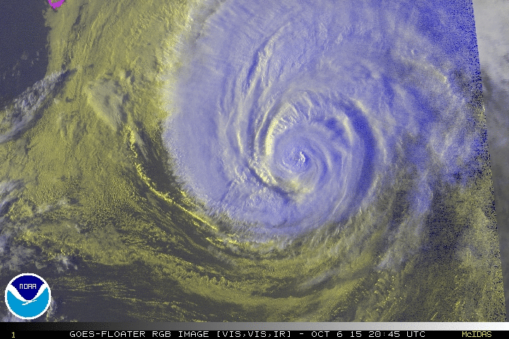
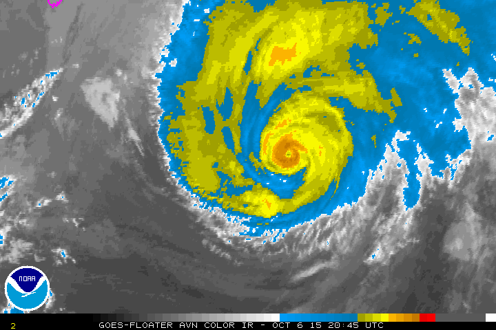
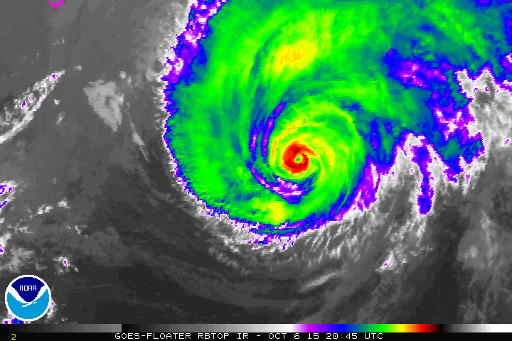
Joaquin is mocking its victims with a pinhole eye.
0 likes
-
emeraldislenc
- Category 2

- Posts: 601
- Joined: Fri Aug 24, 2012 4:49 pm
- Location: Emerald Isle NC

-
ozonepete
- Professional-Met
- Posts: 4743
- Joined: Mon Sep 07, 2009 3:23 pm
- Location: From Ozone Park, NYC / Now in Brooklyn, NY
Re: ATL: JOAQUIN - Hurricane - Discussion
I have been watching hurricanes (and all TCs) on satellite since the first satellite images and I don't ever remember one that looked this good that far out in the Atlantic. The presentation on satellite is just awesome for that area.


0 likes
-
1900hurricane

- Category 5
- Posts: 6063
- Age: 34
- Joined: Fri Feb 06, 2015 12:04 pm
- Location: Houston, TX
- Contact:
Not bad at all.

0 likes
Contract Meteorologist. TAMU & MSST. Fiercely authentic, one of a kind. We are all given free will, so choose a life meant to be lived. We are the Masters of our own Stories.
Opinions expressed are mine alone.
Follow me on Twitter at @1900hurricane : Read blogs at https://1900hurricane.wordpress.com/
Opinions expressed are mine alone.
Follow me on Twitter at @1900hurricane : Read blogs at https://1900hurricane.wordpress.com/
Who is online
Users browsing this forum: No registered users and 47 guests