ATL: DANNY - Remnants - Discussion
Moderator: S2k Moderators
-
tropicwatch

- Category 5

- Posts: 3426
- Age: 62
- Joined: Sat Jun 02, 2007 10:01 am
- Location: Panama City Florida
- Contact:
Here comes the reds:
0 likes
Tropicwatch
Agnes 72', Eloise 75, Elena 85', Kate 85', Charley 86', Florence 88', Beryl 94', Dean 95', Erin 95', Opal 95', Earl 98', Georges 98', Ivan 2004', Arlene 2005', Dennis 2005', Ida 2009' Debby 2012' Irma 2017' Michael 2018'
Agnes 72', Eloise 75, Elena 85', Kate 85', Charley 86', Florence 88', Beryl 94', Dean 95', Erin 95', Opal 95', Earl 98', Georges 98', Ivan 2004', Arlene 2005', Dennis 2005', Ida 2009' Debby 2012' Irma 2017' Michael 2018'
Lots of bearish posts in here and Danny's long term future may indeed be grim should the storm enter the Caribbean but right now that's a long way off and the Atlantic is putting on a show...we have a well organized rapidly developing storm in the deep tropics...something many of us (including me) didn't expect this year...kick back and enjoy the show:)
0 likes


-
lordkev
- Tropical Low

- Posts: 34
- Joined: Tue Sep 09, 2014 10:14 am
- Location: St Kitts, Lesser Antilles
Re: ATL: DANNY - Tropical Storm - Discussion
Of course when we leave St Kitts is when the storm spins up. I was hoping to see a good soaking when something finally came through. However, with how strong it may get, maybe it's better we're off island. Don't see any hurricanes coming to get us in Spain!
0 likes
Buoy 41026 reported 42 knot winds at 22z as Danny passes just to the south of it.
Conditions at 41026 as of
2200 GMT on 08/18/2015:
Unit of Measure: Time Zone:
Click on the graph icon in the table below to see a time series plot of the last five days of that observation.
Air Temperature Air Temperature (ATMP): 75.2 °F
Wind Speed Wind Speed (WSPD): 42.0 kts
Wind Direction Wind Direction (WDIR): E (100 deg)
http://www.ndbc.noaa.gov/station_page.php?station=41026
0 likes
-
AJC3

- Admin

- Posts: 4153
- Age: 62
- Joined: Tue Aug 31, 2004 7:04 pm
- Location: Ballston Spa, New York
- Contact:
Re:
NDG wrote:Buoy 41026 reported 42 knot winds at 22z as Danny passes just to the south of it.
Conditions at 41026 as of
2200 GMT on 08/18/2015:
Unit of Measure: Time Zone:
Click on the graph icon in the table below to see a time series plot of the last five days of that observation.
Air Temperature Air Temperature (ATMP): 75.2 °F
Wind Speed Wind Speed (WSPD): 42.0 kts
Wind Direction Wind Direction (WDIR): E (100 deg)
http://www.ndbc.noaa.gov/station_page.php?station=41026
Talk about a buoy being perfectly placed to catch the near-max winds of an intensifying system. Some serious serendipity there.
0 likes
-
latitude_20

- Tropical Storm

- Posts: 196
- Joined: Wed Jun 30, 2010 6:46 am
- Location: Tulum, Mexico
- Contact:
Re: ATL: DANNY - Tropical Storm - Discussion
I'm going to be at my girl's house on the Yucatan coast on Saturday... might make for an interesting trip indeed. She's already stocking up on food, water and rum.
0 likes
-
Gustywind

- Category 5
- Posts: 12334
- Joined: Mon Sep 03, 2007 7:29 am
- Location: Baie-Mahault, GUADELOUPE
000
AXNT20 KNHC 182346
TWDAT
TROPICAL WEATHER DISCUSSION
NWS NATIONAL HURRICANE CENTER MIAMI FL
805 PM EDT TUE AUG 18 2015
...SPECIAL FEATURES...
TROPICAL DEPRESSION FOUR WAS UPGRADED TO TROPICAL STORM AT
18/2100 UTC. TROPICAL STORM DANNY IS CENTERED NEAR 10.9N37.5W AT
18/2100 UTC OR ABOUT ABOUT 1386 NM E OF THE WINDWARD ISLANDS
MOVING W AT 10 KT. ESTIMATED MINIMUM CENTRAL PRESSURE IS 1008
MB. MAXIMUM SUSTAINED WIND SPEED IS 35 KT WITH GUSTS TO 45 KT.
CLUSTERS OF SCATTERED MODERATE/STRONG CONVECTION ARE FROM 9N-13N
BETWEEN 36W-41W. SCATTERED MODERATE/ISOLATED STRONG CONVECTION
IS WITHIN 60/75 NM OF LINE FROM 9N37W TO 6N40W. PLEASE SEE
LATEST NHC FORECAST/ADVISORY UNDER AWIPS/WMO HEADERS TCMAT4/
WTNT24 KNHC FOR MORE DETAILS.
0 likes
-
ozonepete
- Professional-Met

- Posts: 4743
- Joined: Mon Sep 07, 2009 3:23 pm
- Location: From Ozone Park, NYC / Now in Brooklyn, NY
Re: ATL: DANNY - Tropical Storm - Discussion
latitude_20 wrote:I'm going to be at my girl's house on the Yucatan coast on Saturday... might make for an interesting trip indeed. She's already stocking up on food, water and rum.
the 3 staples, lol...
0 likes
-
Weatherboy1

- Category 5
- Posts: 1190
- Age: 50
- Joined: Mon Jul 05, 2004 1:50 pm
- Location: Jupiter/Sarasota, FL
-
gatorcane

- S2K Supporter

- Posts: 23708
- Age: 48
- Joined: Sun Mar 13, 2005 3:54 pm
- Location: Boca Raton, FL
Here is an interesting graphic I found from the Palm Beach Post (Palm Beach, Florida) that discusses Danny. Actually a few of those tracks are similar to what the models are showing currently.

full article:
http://weatherplus.blog.palmbeachpost.c ... as-formed/
full article:
http://weatherplus.blog.palmbeachpost.c ... as-formed/
0 likes
-
Gustywind
- Category 5
- Posts: 12334
- Joined: Mon Sep 03, 2007 7:29 am
- Location: Baie-Mahault, GUADELOUPE
TROPICAL CYCLONE INFORMATION STATEMENT
WHCA31 TAPA
TROPICAL CYCLONE INFORMATION STATEMENT
ANTIGUA AND BARBUDA METEOROLOGICAL SERVICES
5:47 PM ECT TUE, AUG 18, 2015
THIS IS FOR THE LEEWARD ISLANDS AND BRITISH VIRGIN ISLANDS
ANTIGUA AND BARBUDA METEOROLOGICAL SERVICES IS FOLLOWING THE PROGRESS OF TROPICAL STORM DANNY LOCATED IN THE FAR EASTERN TROPICAL NORTH ATLANTIC.THE SYSTEM IS MOVING WEST AND AN ALERT MAY BE ISSUED IN THE NEXT 6 HOURS. THIS SYSTEM AT THIS TIME POSES NO THREAT TO THE LEEWARD ISLANDS AND BRITISH VIRGIN ISLANDS.
AT 500 PM AST (2100 UTC), THE CENTER OF TROPICAL STORM DANNY WAS LOCATED NEAR LATITUDE 10.9 NORTH, LONGITUDE 37.5 WEST. DANNY IS MOVING TOWARD THE WEST NEAR 12 MPH (19 KM/H). A MOTION TOWARD THE WEST IS EXPECTED TONIGHT, FOLLOWED BY A TURN TOWARD THE WEST-NORTHWEST ON WEDNESDAY.
MAXIMUM SUSTAINED WINDS HAVE INCREASED TO NEAR 40 MPH (65 KM/H) WITH HIGHER GUSTS. ADDITIONAL STRENGTHENING IS FORECAST DURING THE NEXT 48 HOURS, AND DANNY IS EXPECTED TO BECOME A HURRICANE BY THURSDAY.
TROPICAL-STORM-FORCE WINDS EXTEND OUTWARD UP TO 45 MILES (75 KM) FROM THE CENTER.
THE ESTIMATED MINIMUM CENTRAL PRESSURE IS 1008 MB (29.77 INCHES).
FORECASTER KEITHLEY MEADE
0 likes
-
SouthFLTropics

- Category 5
- Posts: 4258
- Age: 50
- Joined: Thu Aug 14, 2003 8:04 am
- Location: Port St. Lucie, Florida
Re:
gatorcane wrote:Here is an interesting graphic I found from the Palm Beach Post (Palm Beach, Florida) that discusses Danny. Actually a few of those tracks are similar to what the models are showing currently.
full article:
http://weatherplus.blog.palmbeachpost.c ... as-formed/
The scary part is I can easily name the 3 shown there hitting Florida. David in 1979, Andrew in 1992, Frances in 2004.
SFT
0 likes
Fourth Generation Florida Native
Personal Storm History: David 79, Andrew 92, Erin 95, Floyd 99, Irene 99, Frances 04, Jeanne 04, Wilma 05, Matthew 16, Irma 17, Ian 22, Nicole 22, Milton 24
Personal Storm History: David 79, Andrew 92, Erin 95, Floyd 99, Irene 99, Frances 04, Jeanne 04, Wilma 05, Matthew 16, Irma 17, Ian 22, Nicole 22, Milton 24
-
MGC

- S2K Supporter
- Posts: 5940
- Joined: Sun Mar 23, 2003 9:05 pm
- Location: Pass Christian MS, or what is left.
Re: ATL: DANNY - Tropical Storm - Discussion
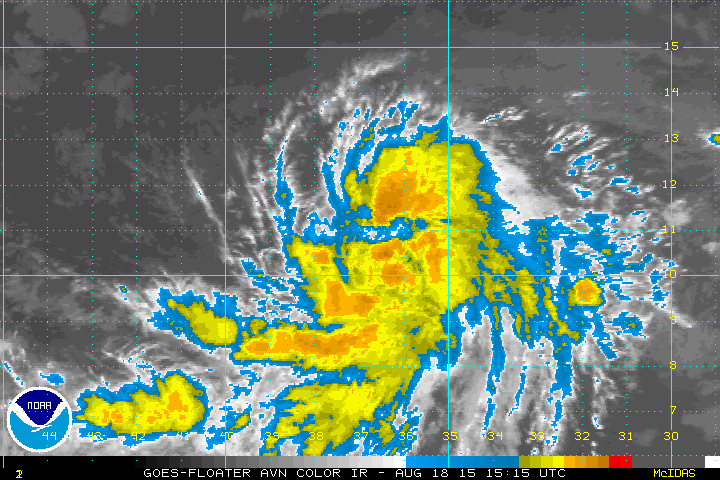
Danny is organizing at a fairly good rate this evening. At this rate, I would not be surprised if Danny becomes a hurricane tomorrow. Further, I would not be surprised if Danny is approaching Cat-3 intensity as the hurricane approaches the islands. Dry air has not been an issue with this system, shear is low and convection is almost completely wrapping around a developing inner core. The ULL ahead of the cyclone are moving away from Danny so upper level conditions look to be improving ahead of the storm. Don't like the model trends this evening, this storm might surprise a lot of people who were expecting a dead season.....MGC
The above is the opinion of MGC and not an official forecast.
The above is the opinion of MGC and not an official forecast.
0 likes

Re:
What kind of alert could they be looking to issue so soon for a system so far away? Then again, I guess memories of Luis in 1995 are still fresh in their minds. The track, with the ominous bend back to the west, currently forecast by the NHC is certainly reminiscent of that taken by Luis.Gustywind wrote:TROPICAL CYCLONE INFORMATION STATEMENT
WHCA31 TAPA
TROPICAL CYCLONE INFORMATION STATEMENT
ANTIGUA AND BARBUDA METEOROLOGICAL SERVICES
5:47 PM ECT TUE, AUG 18, 2015
THIS IS FOR THE LEEWARD ISLANDS AND BRITISH VIRGIN ISLANDS
ANTIGUA AND BARBUDA METEOROLOGICAL SERVICES IS FOLLOWING THE PROGRESS OF TROPICAL STORM DANNY LOCATED IN THE FAR EASTERN TROPICAL NORTH ATLANTIC.THE SYSTEM IS MOVING WEST AND AN ALERT MAY BE ISSUED IN THE NEXT 6 HOURS. ...
0 likes
-
Ivanhater

- Storm2k Moderator

- Posts: 11221
- Age: 39
- Joined: Fri Jul 01, 2005 8:25 am
- Location: Pensacola
Re: ATL: DANNY - Tropical Storm - Discussion
I agree MGC....I really am curious why some of the models like Euro and GFS make this so tiny on their runs ..odd
0 likes
Michael

Re: ATL: DANNY - Tropical Storm - Discussion
Danny really wrapping up on SAT tonite. Looks to be rapidly deepening.
0 likes
-
cycloneye

- Admin
- Posts: 149276
- Age: 69
- Joined: Thu Oct 10, 2002 10:54 am
- Location: San Juan, Puerto Rico
Re: ATL: DANNY - Tropical Storm - Discussion
Up to 45kts
AL, 04, 2015081900, , BEST, 0, 111N, 383W, 45, 1000, TS
AL, 04, 2015081900, , BEST, 0, 111N, 383W, 45, 1000, TS
0 likes
Visit the Caribbean-Central America Weather Thread where you can find at first post web cams,radars
and observations from Caribbean basin members Click Here
and observations from Caribbean basin members Click Here
-
johngaltfla

- Category 5
- Posts: 2073
- Joined: Sun Jul 10, 2005 9:17 pm
- Location: Sarasota County, FL
- Contact:
Re: ATL: DANNY - Tropical Storm - Discussion
cycloneye wrote:Up to 45kts
AL, 04, 2015081900, , BEST, 0, 111N, 383W, 45, 1000, TS
I would be a lot happier if it would intensify rapidly, start to turn NW and miss the box.
0 likes
-
Miami Storm Tracker

- Category 4

- Posts: 916
- Age: 68
- Joined: Sun Jun 13, 2010 10:12 pm
- Location: Key Largo, Fla.
- Contact:
Re: ATL: DANNY - Tropical Storm - Discussion
Ivanhater wrote:I agree MGC....I really am curious why some of the models like Euro and GFS make this so tiny on their runs ..odd
I agree Ivan even as it is in the developing stages the size is by no means small. Great to see you on and posting Ivan, miss all your post from years passed.
0 likes
Who is online
Users browsing this forum: No registered users and 89 guests