Global model runs discussion

Moderator: S2k Moderators

Message
Author
User avatar
cycloneye
Admin
Admin
Posts: 139722
Age: 67
Joined: Thu Oct 10, 2002 10:54 am
Location: San Juan, Puerto Rico

Re:

#3221 Postby cycloneye » Tue Oct 11, 2011 12:14 pm

DLB1752 wrote:12Z GFS seems to drop the storm it had in early runs. Also, hello to everyone! I have been a "reader only" on here for two months, but decided to register and contribute. Been tracking hurricanes since I was I was a child, love the commentary on here. -David


Welcome and enjoy all of what Storm2k has. If you have any question(s),dont hesitate to ask.
0 likes   
Visit the Caribbean-Central America Weather Thread where you can find at first post web cams,radars
and observations from Caribbean basin members Click Here

User avatar
wxman57
Moderator-Pro Met
Moderator-Pro Met
Posts: 22512
Age: 66
Joined: Sat Jun 21, 2003 8:06 pm
Location: Houston, TX (southwest)

Re: Global Model Runs Discussion

#3222 Postby wxman57 » Tue Oct 11, 2011 12:35 pm

I'm quite disappointed in the 12Z GFS. No major hurricane threatening the SE U.S. at 384 hours on this run! ;-)

Clearly, the Caribbean has been quite a hostile place for development this season. Gulf of Mexico, too. Bones is about ready to declare the 2011 season to be over.
0 likes   

User avatar
FireRat
Category 5
Category 5
Posts: 1151
Age: 37
Joined: Sun Sep 26, 2010 11:38 pm
Location: North Carolina

Re: Global Model Runs Discussion

#3223 Postby FireRat » Tue Oct 11, 2011 12:43 pm

It would be weird as heck if nothing formed despite the La Nina and especially the strong MJO forecast!! Hell, if that panned out, we can probably forget that the La NIna is going to spell warm and dry humdrum winter weather here in Florida! :lol:

We'll probably freeze this winter again, just like last! :wink:

It'll probably snow at this rate :cold:
0 likes   
Georges '98, Irene '99, Frances '04, Jeanne '04, Katrina '05, Wilma '05, Gustav '08, Isaac '12, Matthew '16, Florence '18, Michael '18, Ian '22

User avatar
wxman57
Moderator-Pro Met
Moderator-Pro Met
Posts: 22512
Age: 66
Joined: Sat Jun 21, 2003 8:06 pm
Location: Houston, TX (southwest)

Re: Global Model Runs Discussion

#3224 Postby wxman57 » Tue Oct 11, 2011 1:01 pm

Even though the Nino 3.4 region is technically in a La Nina, the cooler SST anomalies are confined to a very narrow area between 120W-170W near the Equator, as can be seen in the first image below (this year's anomaly as of yesterday):

Image

Compare the image above (2011) to last year's La Nina and there's quite a difference. I'm wondering if the much warmer water in Nino 1-2 regions, which is likely responsible for the powerful hurricanes in the East Pac, is also having a negative influence on conditions across the Gulf/Caribbean?

Image
0 likes   

dwsqos2

Re: Global Model Runs Discussion

#3225 Postby dwsqos2 » Tue Oct 11, 2011 1:50 pm

There's nothing interesting on the 12Z Euro; I declare my logic-free hurricane season forecast uncommonly good.

The posts in this forum are NOT official forecast and should not be used as such. They are just the opinion of the poster and may or may not be backed by sound meteorological data. They are NOT endorsed by any professional institution or storm2k.org. For official information, please refer to the NHC and NWS products.
0 likes   

hcane27
Tropical Storm
Tropical Storm
Posts: 229
Joined: Tue Jan 31, 2006 7:33 pm

Re: Global Model Runs Discussion

#3226 Postby hcane27 » Tue Oct 11, 2011 2:08 pm

FireRat wrote:It would be weird as heck if nothing formed despite the La Nina and especially the strong MJO forecast!! Hell, if that panned out, we can probably forget that the La NIna is going to spell warm and dry humdrum winter weather here in Florida! :lol:

We'll probably freeze this winter again, just like last! :wink:

It'll probably snow at this rate :cold:


I have come to the conclusions below .....

1. just becasue there is a "la Nina" does not necessarily mean there will be a lot of activity
2. the effect of the "strong MJO" is overdone .... as it pertains to the Atlantic area ... including the Caribbean and Gulf of Mexico

I am in the process of looking at the history of the above and will send along when complete .....
0 likes   

User avatar
wxman57
Moderator-Pro Met
Moderator-Pro Met
Posts: 22512
Age: 66
Joined: Sat Jun 21, 2003 8:06 pm
Location: Houston, TX (southwest)

Re: Global Model Runs Discussion

#3227 Postby wxman57 » Tue Oct 11, 2011 2:15 pm

hcane27 wrote:I have come to the conclusions below .....

1. just becasue there is a "la Nina" does not necessarily mean there will be a lot of activity
2. the effect of the "strong MJO" is overdone .... as it pertains to the Atlantic area ... including the Caribbean and Gulf of Mexico

I am in the process of looking at the history of the above and will send along when complete .....


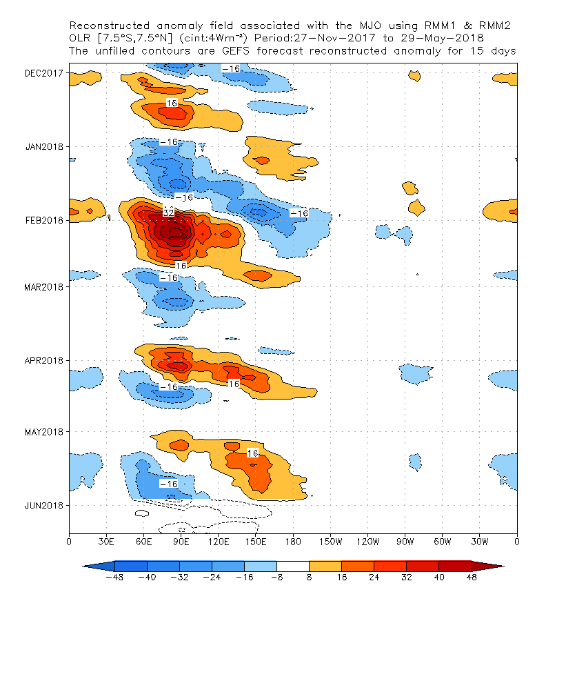
Note that the strong MJO remains in the Western Pacific, west of the date line (180 deg). I suggest checking out a website I made about 10 years ago describing the MJO and its impact on the Gulf/Caribbean:
http://myweb.cableone.net/nolasue/mjo/

Image
0 likes   

User avatar
FireRat
Category 5
Category 5
Posts: 1151
Age: 37
Joined: Sun Sep 26, 2010 11:38 pm
Location: North Carolina

Re: Global Model Runs Discussion

#3228 Postby FireRat » Tue Oct 11, 2011 2:22 pm

Yep, that's pretty much the deal. "La Nina" and "MJO" simply imply trends and not necessarily events set in stone. Last year, the "La Nina" in place in December was first thought to bear warm and dry weather to us here in Florida, but then a NAO (Negative Atlantic Oscillation phenomenon) changed all that and we literally froze for weeks on end. I was actually thrilled by the unusual cold as it had been a hellish summer just like this one. If the Iguanas could somehow wear parkas and the fruits better protected in these parts, I would love another cold winter after THIS INFERNAL summer!

Now back on track, the historical favorite week for October storms is 5 days away so it will be interesting to see if, in a few days, the models jump on something forming down there in the mid-range. For now, it's pretty much zilch as Wxman57's been saying.
0 likes   
Georges '98, Irene '99, Frances '04, Jeanne '04, Katrina '05, Wilma '05, Gustav '08, Isaac '12, Matthew '16, Florence '18, Michael '18, Ian '22

hcane27
Tropical Storm
Tropical Storm
Posts: 229
Joined: Tue Jan 31, 2006 7:33 pm

Re: Global Model Runs Discussion

#3229 Postby hcane27 » Tue Oct 11, 2011 2:29 pm

So then the real "fly in the ointment" is the ability to accurately forecast the strength and timing of the MJO pulse into the Atlantic area ?? As it appears that most of the impulses do not reach past the eastern Pacific , or if they do the "strength" may well be below that which would significantly enhance tropical cyclone formation.
0 likes   

User avatar
wxman57
Moderator-Pro Met
Moderator-Pro Met
Posts: 22512
Age: 66
Joined: Sat Jun 21, 2003 8:06 pm
Location: Houston, TX (southwest)

Re: Global Model Runs Discussion

#3230 Postby wxman57 » Tue Oct 11, 2011 2:48 pm

hcane27 wrote:So then the real "fly in the ointment" is the ability to accurately forecast the strength and timing of the MJO pulse into the Atlantic area ?? As it appears that most of the impulses do not reach past the eastern Pacific , or if they do the "strength" may well be below that which would significantly enhance tropical cyclone formation.


Predicting the arrival (in East Pac) and strength of the MJO pulse is somewhat difficult. A moderate MJO reaching the East Pac can enhance development in the Gulf and Caribbean about 10-14 days later. And you have to understand that some of those graphics posted that identify rising air associated with an MJO pulse may actually be showing rising air due to other features not MJO-related. That's the case for the current projections, as the MJO is clearly still in the West Pacific and not approaching the East Pacific.

In recent years, most of the MJO pulses have been relatively weak by the time they reach the East Pac.
0 likes   

HURRICANELONNY
Category 5
Category 5
Posts: 1381
Joined: Wed May 07, 2003 6:48 am
Location: HOLLYWOOD.FL

#3231 Postby HURRICANELONNY » Tue Oct 11, 2011 2:58 pm

The ECMWF and NOGAPS models continue to predict that a strong tropical disturbance capable of becoming a tropical depression could form in the Western Caribbean early next week. Some of the spin and moisture for this storm could potentially come from an area of disturbed weather in the Eastern Pacific, (Invest 99E), that is currently just offshore of the Mexico/Guatemala border. Invest 99E is expected to move inland over Central America over the next few days, bringing very heavy rains capable of causing flash flooding and mudslides to Southeast Mexico, Guatemala, and El Salvador.

Jeff Masters
0 likes   
hurricanelonny

User avatar
blp
Category 5
Category 5
Posts: 2807
Age: 45
Joined: Thu Sep 09, 2004 7:51 pm
Location: Miami, FL
Contact:

Re: Global Model Runs Discussion

#3232 Postby blp » Tue Oct 11, 2011 5:10 pm

12z Euro has followed the GFS in showing the system getting caught over land. If you take out all the phantom storms at 300+ hours that it has been showing for weeks the GFS has actually been doing OK. To my untrained eye, looking at the models it looks like the EPAC monsoon gyre is too strong to allow development on the W. Carribean side. I think something will form it just won't happen as soon as we thought. Until the EPAC action subsides and the energy moves into the Carribean we will continue to wait for development.

Reading Wxman57's site (http://myweb.cableone.net/nolasue/mjo/) about MJO states: "What Maloney and Hartmann found was that about 15 days after a MJO reaches the Eastern Pacific, there is typically a sharp rise in tropical cyclone development in the Gulf of Mexico and Caribbean Sea." which would make sense because most of the upward energy needs time to move from the EPAC to the WCAR. Taking that into consideration it would delay development to sometime toward the end of the week of the 24th. So we may need to be a little more patient. Let's see what happens.
0 likes   
The following post is NOT an official forecast and should not be used as such. It is just the opinion of the poster and may or may not be backed by sound meteorological data. It is NOT endorsed by any professional institution including storm2k.org For Official Information please refer to the NHC and NWS products.

User avatar
Ptarmigan
Category 5
Category 5
Posts: 5273
Joined: Wed Aug 16, 2006 9:06 pm

Re: Global Model Runs Discussion

#3233 Postby Ptarmigan » Tue Oct 11, 2011 6:53 pm

ROCK wrote:I was waiting on you to chime in..... :lol: you are the stats guy.....I did re-review the past TX hurricanes PDF and you are right. There has been some late season hits so I stand corrected. Should have narrowed it down to Galveston major landfall... :D odds are way against it yes...but this year you can throw odds out the window. IMO....


You made a post for me. :lol: As I mentioned 1886 and 1949 occurred in La Nina. 1886 started Neutral than went to La Nina and it was a very dry year. 1949 was La Nina and went into a prolonged drought of the 1950s. This is based on MEI.

MEI datasets.
1950 to Present
http://www.esrl.noaa.gov/psd/enso/mei/table.html

1871 to 2005
http://www.esrl.noaa.gov/psd/enso/mei.e ... e.ext.html

ENSO Region 3.4
http://www.cgd.ucar.edu/cas/catalog/cli ... index.html

Japanese Meteorological Agency ENSO
ftp://www.coaps.fsu.edu/pub/JMA_SST_Ind ... y.filter-5

This one goes back to 1871 to 2007. NOAA uses ENSO Region 3.4, but when I compared the two, the values were different. Sometimes way off, but both indicate they were La Nina and El Nino. I don't know why. The same goes with Japanese Meteorological Agency ENSO data.
0 likes   

User avatar
ROCK
Category 5
Category 5
Posts: 9254
Age: 53
Joined: Tue Aug 17, 2004 7:30 am
Location: Kemah, Texas

Re: Global Model Runs Discussion

#3234 Postby ROCK » Tue Oct 11, 2011 11:56 pm

the 0Z GFS back on board with a BOC system at 240hr moving up the Texas coast and into SW LA. Very similar to some of the EURO runs we have seen recently. Interesting....stuff...
0 likes   

User avatar
ROCK
Category 5
Category 5
Posts: 9254
Age: 53
Joined: Tue Aug 17, 2004 7:30 am
Location: Kemah, Texas

Re: Global Model Runs Discussion

#3235 Postby ROCK » Tue Oct 11, 2011 11:59 pm

NOGAPS also sees it on the yucatan at 180hr.....model support coming on board with something. When all of them are sniffing this then its a good bet.

https://www.fnmoc.navy.mil/wxmap_cgi/cg ... t=Tropical
0 likes   

User avatar
alienstorm
Category 1
Category 1
Posts: 496
Joined: Tue Jul 31, 2007 1:29 pm
Location: Miami Fla western suburb

Re: Global Model Runs Discussion

#3236 Postby alienstorm » Wed Oct 12, 2011 10:51 am

This will be generated from the leftover of TD12 in the Eastern Pacific.
0 likes   
Personal Forecast Disclaimer:The posts in this forum are NOT official forecast and should not be used as such. They are just the opinion of the poster and may or may not be backed by sound meteorological data. They are NOT endorsed by any professional institution or storm2k.org. For official information, please refer to the NHC and NWS products.

User avatar
ROCK
Category 5
Category 5
Posts: 9254
Age: 53
Joined: Tue Aug 17, 2004 7:30 am
Location: Kemah, Texas

Re: Global Model Runs Discussion

#3237 Postby ROCK » Wed Oct 12, 2011 12:48 pm

12z GFS now flopping back to up and out scenario.....the 0z EURO sort of buries it in the yucatan so still nothing of a consensus....12Z EURO out in few...

12Z CMC shows a system moving up and around the yucatan and ends run in the BOC at 144hr.
0 likes   

User avatar
wxman57
Moderator-Pro Met
Moderator-Pro Met
Posts: 22512
Age: 66
Joined: Sat Jun 21, 2003 8:06 pm
Location: Houston, TX (southwest)

Re: Global Model Runs Discussion

#3238 Postby wxman57 » Wed Oct 12, 2011 12:57 pm

It's pretty clear that none of the models has a handle on what's going to happen beyond the next 3-4 days. I don't think anything will develop over the next week.
0 likes   

User avatar
Blown Away
S2K Supporter
S2K Supporter
Posts: 9876
Joined: Wed May 26, 2004 6:17 am

Re: Global Model Runs Discussion

#3239 Postby Blown Away » Wed Oct 12, 2011 1:48 pm

Models not showing much at least over the next week, maybe it's almost time to say we might be seeing the end of the 2011 season, with the exception of some rogue low pressure the spins up in the middle Atlantic and gets a name!
0 likes   
Hurricane Eye Experience: David 79, Irene 99, Frances 04, Jeanne 04, Wilma 05... EYE COMING MY WAY IN 2024…
Hurricane Brush Experience: Andrew 92, Erin 95, Floyd 99, Matthew 16, Irma 17, Ian 22, Nicole 22…

User avatar
cycloneye
Admin
Admin
Posts: 139722
Age: 67
Joined: Thu Oct 10, 2002 10:54 am
Location: San Juan, Puerto Rico

Re: Global Model Runs Discussion

#3240 Postby cycloneye » Wed Oct 12, 2011 2:19 pm

The Colorado State University folks (Dr Klotzbach/Dr Gray) forecast an average next two weeks of October ending on the 25th. They forsee the ACE units to be between 5-7 during this two week period. But the models are not too bullish right now for the next seven to ten days.Let's see if that changes in next runs.

http://hurricane.atmos.colostate.edu/In ... 2_2011.pdf
0 likes   
Visit the Caribbean-Central America Weather Thread where you can find at first post web cams,radars
and observations from Caribbean basin members Click Here


Return to “2015”

Who is online

Users browsing this forum: No registered users and 6 guests