ATL: DANNY - Models
Moderator: S2k Moderators

Re:
NCSTORMMAN wrote:Safe to say it dies out as it goes west? No threat to US then? Is shear the issue?
If it tracks westward towards the Caribbean Sea, yes, it will be destroyed the persistent westerly shear.
I think its best chances for development & strengthening is during the next 72-96 hrs and it better stay on a low latitude course during the short term. In the long term it will have a better chance of surviving if it goes north of the Windward Islands away from the windshear over the Caribbean.
0 likes


-
NCSTORMMAN
Re:
gatorcane wrote:18Z Guidance with the some intensity models back up to CAT 3. Obviously they are overdoing it, but it is telling me maybe we will get a tropical storm out of this before all is said and done. The GFS-based intensity guidance not impressed:
Isn't the ship model the one that the NHC relies on for intensity related forecasting?
0 likes


Re: ATL: INVEST 96L- Models
Post by Levi Cowan
2h2 hours ago
Levi Cowan @TropicalTidbits
After poor init and inner nest losing 96L, HWRF parent domain likes genesis near same location as the Euro, ~40W, 10N
0 likes
The following post is NOT an official forecast and should not be used as such. It is just the opinion of the poster and may or may not be backed by sound meteorological data. It is NOT endorsed by any professional institution including storm2k.org For Official Information please refer to the NHC and NWS products.
-
NCSTORMMAN
-
AtlanticWind

- S2K Supporter

- Posts: 1898
- Age: 67
- Joined: Sun Aug 08, 2004 9:57 pm
- Location: Plantation,Fla
Re: ATL: INVEST 96L- Models
0 likes

Re: ATL: INVEST 96L- Models
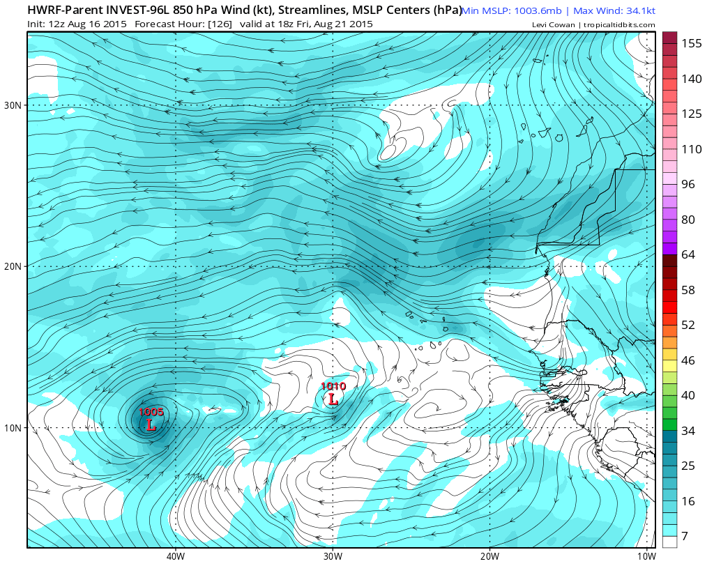
You could say that again. Is that a realistic remote possibility?AtlanticWind wrote:http://www.tropicaltidbits.com/analysis/models/?model=hwrf®ion=96L&pkg=mslp_wind&runtime=2015081618&fh=126&xpos=0&ypos=122
Hwrf really bullish
0 likes
-
cycloneye

- Admin

- Posts: 149275
- Age: 69
- Joined: Thu Oct 10, 2002 10:54 am
- Location: San Juan, Puerto Rico
Re: ATL: INVEST 96L- Models
HWRF scenario is overdone.
0 likes
Visit the Caribbean-Central America Weather Thread where you can find at first post web cams,radars
and observations from Caribbean basin members Click Here
and observations from Caribbean basin members Click Here
-
AtlanticWind
- S2K Supporter
- Posts: 1898
- Age: 67
- Joined: Sun Aug 08, 2004 9:57 pm
- Location: Plantation,Fla
Re: ATL: INVEST 96L- Models
abajan wrote:You could say that again. Is that a realistic remote possibility?AtlanticWind wrote:http://www.tropicaltidbits.com/analysis/models/?model=hwrf®ion=96L&pkg=mslp_wind&runtime=2015081618&fh=126&xpos=0&ypos=122
Hwrf really bullish
I would say it is a possibility, since it has other intensity model support , but maybe not likely.
0 likes

-
cycloneye
- Admin
- Posts: 149275
- Age: 69
- Joined: Thu Oct 10, 2002 10:54 am
- Location: San Juan, Puerto Rico
Re: ATL: INVEST 96L- Models
TROPICAL CYCLONE GUIDANCE MESSAGE
NWS NATIONAL HURRICANE CENTER MIAMI FL
0044 UTC MON AUG 17 2015
DISCLAIMER...NUMERICAL MODELS ARE SUBJECT TO LARGE ERRORS.
PLEASE REFER TO NHC OFFICIAL FORECASTS FOR TROPICAL CYCLONE
AND SUBTROPICAL CYCLONE INFORMATION.
ATLANTIC OBJECTIVE AIDS FOR
DISTURBANCE INVEST (AL962015) 20150817 0000 UTC
...00 HRS... ...12 HRS... ...24 HRS... ...36 HRS...
150817 0000 150817 1200 150818 0000 150818 1200
LAT LON LAT LON LAT LON LAT LON
BAMS 10.0N 29.2W 10.4N 31.5W 10.7N 34.1W 10.9N 37.0W
BAMD 10.0N 29.2W 10.2N 31.4W 10.5N 33.5W 10.9N 35.7W
BAMM 10.0N 29.2W 10.3N 31.4W 10.7N 33.7W 11.0N 35.9W
LBAR 10.0N 29.2W 10.1N 31.9W 10.3N 35.1W 10.7N 38.2W
SHIP 25KTS 32KTS 42KTS 50KTS
DSHP 25KTS 32KTS 42KTS 50KTS
...48 HRS... ...72 HRS... ...96 HRS... ..120 HRS...
150819 0000 150820 0000 150821 0000 150822 0000
LAT LON LAT LON LAT LON LAT LON
BAMS 11.1N 40.1W 11.1N 45.5W 10.7N 49.6W 10.5N 52.8W
BAMD 11.3N 37.8W 12.0N 41.4W 12.5N 44.5W 13.0N 47.9W
BAMM 11.2N 38.1W 11.6N 41.9W 11.8N 44.8W 12.0N 47.9W
LBAR 11.3N 41.1W 12.2N 46.1W 12.9N 49.7W 15.1N 51.7W
SHIP 56KTS 68KTS 77KTS 80KTS
DSHP 56KTS 68KTS 77KTS 80KTS
...INITIAL CONDITIONS...
LATCUR = 10.0N LONCUR = 29.2W DIRCUR = 270DEG SPDCUR = 11KT
LATM12 = 10.0N LONM12 = 27.0W DIRM12 = 270DEG SPDM12 = 13KT
LATM24 = 10.1N LONM24 = 24.4W
WNDCUR = 25KT RMAXWD = 60NM WNDM12 = 20KT
CENPRS = 1011MB OUTPRS = 1014MB OUTRAD = 150NM SDEPTH = M
RD34NE = 0NM RD34SE = 0NM RD34SW = 0NM RD34NW = 0NM
0 likes
Visit the Caribbean-Central America Weather Thread where you can find at first post web cams,radars
and observations from Caribbean basin members Click Here
and observations from Caribbean basin members Click Here


-
Yellow Evan

- Professional-Met

- Posts: 16231
- Age: 27
- Joined: Fri Jul 15, 2011 12:48 pm
- Location: Henderson, Nevada/Honolulu, HI
- Contact:
Re: ATL: INVEST 96L- Models
Code: Select all
                    * ATLANTIC     SHIPS INTENSITY FORECAST          *
                    * IR SAT DATA AVAILABLE,       OHC AVAILABLE     *
                    *  INVEST      AL962015  08/17/15  00 UTC        *

TIME (HR)          0     6    12    18    24    36    48    60    72    84    96   108   120
V (KT) NO LAND    25    28    32    37    42    50    56    62    68    74    77    79    80
V (KT) LAND       25    28    32    37    42    50    56    62    68    74    77    79    80
V (KT) LGE mod    25    27    30    33    37    44    53    59    64    71    79    86    88
Storm Type      TROP  TROP  TROP  TROP  TROP  TROP  TROP  TROP  TROP  TROP  TROP  TROP  TROP

SHEAR (KT)         2     1     3     2     1     3     7     3     3     7    14     8    12
SHEAR ADJ (KT)     8    10     4     1     2     3     5     6     5    -1    -6    -5    -5
SHEAR DIR        137    18    28    28   360   194   219   188   112   111   152   165   189
SST (C)         28.0  27.9  27.7  27.6  27.4  27.4  27.5  27.7  27.8  27.7  27.7  27.8  27.8
POT. INT. (KT)   137   136   133   132   129   129   130   132   133   131   131   133   133
ADJ. POT. INT.   138   136   133   132   129   128   129   130   130   126   126   129   129
200 MB T (C)   -52.8 -53.2 -53.1 -52.8 -52.8 -53.2 -53.1 -53.4 -53.1 -53.3 -53.2 -53.4 -53.2
TH_E DEV (C)       7     7     7     7     7     7     7     7     6     7     8     8     9
700-500 MB RH     64    65    65    66    67    62    63    62    63    56    50    45    41
MODEL VTX (KT)     5     5     5     6     6     6     7     7     8     8     9    10    10
850 MB ENV VOR    58    48    46    41    36    34    28    35    50    52    51    47    36
200 MB DIV        62    76    63    63    71    70   121    44    29    -3    -6   -29   -40
700-850 TADV      -3    -4    -4    -4    -6    -5    -8    -8   -11    -7    -1     0    -1
LAND (KM)       1374  1481  1588  1700  1813  1846  1641  1458  1324  1205  1120  1029   930
LAT (DEG N)     10.0  10.2  10.3  10.5  10.7  11.0  11.2  11.4  11.6  11.7  11.8  11.9  12.0
LONG(DEG W)     29.2  30.3  31.4  32.5  33.7  35.9  38.1  40.2  41.9  43.5  44.8  46.3  47.9
STM SPEED (KT)    11    11    11    11    11    11    10     9     8     7     7     8     8
HEAT CONTENT      16    15    15    15    16    21    18    12    12    16    18    20    27

  FORECAST TRACK FROM BAMM      INITIAL HEADING/SPEED (DEG/KT):270/ 11      CX,CY: -10/  0
  T-12 MAX WIND:  20            PRESSURE OF STEERING LEVEL (MB):  563  (MEAN=624)
  GOES IR BRIGHTNESS TEMP. STD DEV.  50-200 KM RAD:  14.4 (MEAN=14.5)
  % GOES IR PIXELS WITH T < -20 C    50-200 KM RAD:  62.0 (MEAN=65.0)

                        INDIVIDUAL CONTRIBUTIONS TO INTENSITY CHANGE
                         6   12   18   24   36   48   60   72   84   96  108  120
                        ----------------------------------------------------------
  SAMPLE MEAN CHANGE     1.   2.   3.   4.   6.   8.   9.  11.  12.  12.  13.  14.
  SST POTENTIAL          0.   0.   1.   2.   6.  11.  17.  22.  26.  28.  30.  31.
  VERTICAL SHEAR MAG     1.   3.   4.   6.   9.  12.  14.  16.  17.  16.  15.  14.
  VERTICAL SHEAR ADJ    -1.  -1.  -1.  -1.  -2.  -3.  -4.  -4.  -4.  -2.  -1.  -1.
  VERTICAL SHEAR DIR     0.   1.   2.   2.   3.   1.   0.   1.   2.   2.   1.   0.
  PERSISTENCE            1.   1.   2.   2.   2.   2.   2.   1.   1.   1.   0.   0.
  200/250 MB TEMP.       0.   0.   0.   0.  -1.  -1.  -1.  -1.   0.   0.   0.   0.
  THETA_E EXCESS         0.  -1.  -1.  -2.  -2.  -3.  -4.  -6.  -8.  -9.  -9. -10.
  700-500 MB RH          0.   0.   0.  -1.  -1.  -1.  -2.  -2.  -2.  -2.  -1.  -1.
  MODEL VTX TENDENCY     0.   0.   0.   0.   0.   0.   0.   1.   1.   1.   2.   1.
  850 MB ENV VORTICITY   0.   0.   0.   1.   1.   1.   1.   1.   1.   2.   2.   2.
  200 MB DIVERGENCE      0.   1.   1.   1.   2.   4.   4.   4.   3.   2.   1.   1.
  850-700 T ADVEC        0.   0.   0.   0.   0.   0.   0.   0.   0.   0.   1.   1.
  ZONAL STORM MOTION     0.   0.   0.   1.   1.   1.   1.   2.   2.   2.   2.   2.
  STEERING LEVEL PRES    0.   0.   0.   0.   0.   1.   0.   1.   1.   1.   1.   0.
  DAYS FROM CLIM. PEAK   0.   0.   0.   0.   0.   0.   0.   0.   0.   0.   0.   0.
  GOES PREDICTORS        0.   1.   1.   1.   0.   0.  -1.  -1.  -2.  -2.  -1.  -1.
  OCEAN HEAT CONTENT     0.   0.   0.   0.   0.   0.   0.   0.   0.   0.   0.   0.
                        ----------------------------------------------------------
  TOTAL CHANGE           3.   7.  12.  17.  25.  31.  37.  43.  49.  52.  54.  55.

   ** 2013 ATLANTIC RI INDEX AL962015 INVEST     08/17/15  00 UTC **
           ( 30 KT OR MORE MAX WIND INCREASE IN NEXT 24 HR)

 12 HR PERSISTENCE (KT):   5.0 Range:-49.5 to  33.0 Scaled/Wgted Val:  0.7/  1.9
 850-200 MB SHEAR (KT) :   1.9 Range: 28.8 to   2.9 Scaled/Wgted Val:  1.0/  1.2
 STD DEV OF IR BR TEMP :  14.4 Range: 37.5 to   2.9 Scaled/Wgted Val:  0.7/  0.9
 850-700 MB REL HUM (%):  75.2 Range: 43.2 to  93.5 Scaled/Wgted Val:  0.6/  0.8
 POT = MPI-VMAX (KT)   : 108.9 Range: 28.4 to 139.1 Scaled/Wgted Val:  0.7/  0.5
 Heat content (KJ/cm2) :  15.4 Range:  0.0 to 155.1 Scaled/Wgted Val:  0.1/  0.0
 D200 (10**7s-1)       :  67.0 Range:-23.1 to 181.5 Scaled/Wgted Val:  0.4/  0.2
 % area w/pixels <-30 C:  46.0 Range: 15.3 to 100.0 Scaled/Wgted Val:  0.4/  0.1

 Prob of RI for 25 kt RI threshold=    43% is   3.6 times the sample mean(11.9%)
 Prob of RI for 30 kt RI threshold=    28% is   3.7 times the sample mean( 7.6%)
 Prob of RI for 35 kt RI threshold=    17% is   3.6 times the sample mean( 4.6%)
 Prob of RI for 40 kt RI threshold=    11% is   3.7 times the sample mean( 3.0%)
0 likes

Is the GFS having feedback issues? It seems to pull a second low to the east almost out of nowhere.
0 likes
The above post is not official and should not be used as such. It is the opinion of the poster and may or may not be backed by sound meteorological data. It is not endorsed by any professional institution or storm2k.org. For official information, please refer to the NHC and NWS products.
Re: ATL: INVEST 96L- Models
If you thought the 18z HWRF was off it's rocker, the 00z has this at 70kt / 975mb by 72 hours.
End of the run, fluctuates from 75-85 knots at 965mb for the last day and a half:

End of the run, fluctuates from 75-85 knots at 965mb for the last day and a half:
0 likes
Re: ATL: INVEST 96L- Models
BTW, the 0z Euro dropped development with 96L, not surprising.
0 likes
Who is online
Users browsing this forum: No registered users and 24 guests