Global model runs discussion

Moderator: S2k Moderators

Message
Author
User avatar
cycloneye
Admin
Admin
Posts: 145299
Age: 68
Joined: Thu Oct 10, 2002 10:54 am
Location: San Juan, Puerto Rico

Re: Global Model Runs Discussion

#4521 Postby cycloneye » Wed Apr 24, 2013 9:26 am

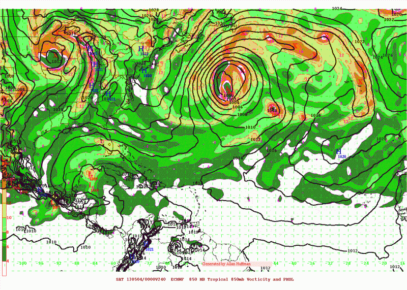
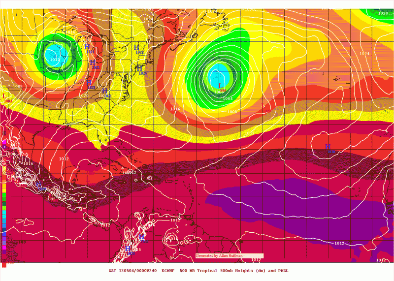
NDG wrote:Hmm, Euro shows at least two runs in a row of surface pressures lowering in the NW Caribbean in its long range forecast due to a cut off UL trough in that area.

http://i20.photobucket.com/albums/b245/ ... b38a05.gif

http://i20.photobucket.com/albums/b245/ ... a3952d.gif


Well,unless the screaming upper shear abates from the area,I don't see anything happening. But things may change in a few weeks.

Image
0 likes   
Visit the Caribbean-Central America Weather Thread where you can find at first post web cams,radars
and observations from Caribbean basin members Click Here

User avatar
NDG
S2K Supporter
S2K Supporter
Posts: 15446
Joined: Sun Jul 09, 2006 10:14 pm
Location: Orlando, FL

Re: Global Model Runs Discussion

#4522 Postby NDG » Wed Apr 24, 2013 9:52 am

:uarrow: I am a big believer that very early in the season UL shear (divergence) helps in development of most hybrid/subtropical systems of some sort, at least initially in its beginning stages.
0 likes   

User avatar
cycloneye
Admin
Admin
Posts: 145299
Age: 68
Joined: Thu Oct 10, 2002 10:54 am
Location: San Juan, Puerto Rico

Re: Global Model Runs Discussion

#4523 Postby cycloneye » Wed May 08, 2013 2:55 pm

As known in other threads,the MJO will have a strong pulse that may reach the EPAC and Atlantic Basin by late May going into early June. Let's see how the global models deal with this pulse in the next couple of weeks. I have seen GFS trying to spin something in the Western Caribbean but it has stayed in the 384 hour range for the past few runs so no credence to that until the timeframe moves. GFS likes to spin things faster before the MJO arrives. For now the GEM model (old CMC) has a EPAC development but is still mid range.

Image
0 likes   
Visit the Caribbean-Central America Weather Thread where you can find at first post web cams,radars
and observations from Caribbean basin members Click Here

supercane4867
Category 5
Category 5
Posts: 4966
Joined: Wed Nov 14, 2012 10:43 am

Re: Global Model Runs Discussion

#4524 Postby supercane4867 » Thu May 09, 2013 9:06 am

06z GFS

Image
0 likes   

OuterBanker
S2K Supporter
S2K Supporter
Posts: 1731
Joined: Wed Feb 26, 2003 10:53 am
Location: Nags Head, NC
Contact:

Re: Global Model Runs Discussion

#4525 Postby OuterBanker » Thu May 09, 2013 2:07 pm

supercane4867 wrote:06z GFS

Image


Apparently, two days after the start of the Epac season.
0 likes   

User avatar
cycloneye
Admin
Admin
Posts: 145299
Age: 68
Joined: Thu Oct 10, 2002 10:54 am
Location: San Juan, Puerto Rico

Re: Global Model Runs Discussion

#4526 Postby cycloneye » Sun May 12, 2013 8:02 am

Interesting paper about the different model cycles and how they are different. One of the things this information has is that the GFS 00z cycle dosen't handle well tropical winds in the lower troposphere. And the 06z and 18z cycles are the worse.

http://www.emc.ncep.noaa.gov/gmb/wx24fy ... _fyang.pdf
0 likes   
Visit the Caribbean-Central America Weather Thread where you can find at first post web cams,radars
and observations from Caribbean basin members Click Here

User avatar
cycloneye
Admin
Admin
Posts: 145299
Age: 68
Joined: Thu Oct 10, 2002 10:54 am
Location: San Juan, Puerto Rico

Re: Global Model Runs Discussion

#4527 Postby cycloneye » Wed May 15, 2013 7:55 pm

Here is a very interesting articule about the improvements by GFS and how it matches with ECMWF as new upgrades will occur down the road.Read the whole articule at link below.

http://www.washingtonpost.com/blogs/cap ... rediction/

A little known fact is that the source of most weather forecasts delivered on your TV news and smartphones are two supercomputers housed in Reston, Va. and Orlando, Fl. An infusion of funding into the National Weather Service from Hurricane Sandy relief legislation promises to facilitate massive upgrades to these machines that may dramatically improve local, national, and global weather forecasts.

Congress has approved large parts of NOAA’s spending plan under the Disaster Relief Appropriations Act of 2013 that will direct $23.7 million (or $25 million before sequestration), a so-called “Sandy supplemental” to the National Weather Service (NWS) for forecasting equipment and supercomputer infrastructure.

“This is a breakthrough moment for the National Weather Service and the entire U.S. weather enterprise in terms of positioning itself with the computing capacity and more sophisticated models we’ve all been waiting for,” said Louis Uccellini, director of the National Weather Service.

Last year, criticism began to emerge concerning the inferior accuracy of the NWS’s Global Forecast System (GFS) model – run on earlier versions of the supercomputers – compared to the model run at the European Centre for Medium Range Forecasting (ECMWF) based in the United Kingdom. The GFS and ECMWF models are, by far, the most heavily relied on by meteorologists around the world for forecasting.
0 likes   
Visit the Caribbean-Central America Weather Thread where you can find at first post web cams,radars
and observations from Caribbean basin members Click Here

User avatar
Cyclenall
Category 5
Category 5
Posts: 6666
Joined: Thu Jun 08, 2006 10:01 pm
Location: Ontario, Canada

Mystery

#4528 Postby Cyclenall » Wed May 15, 2013 9:07 pm

cycloneye wrote:Interesting paper about the different model cycles and how they are different. One of the things this information has is that the GFS 00z cycle dosen't handle well tropical winds in the lower troposphere. And the 06z and 18z cycles are the worse.

http://www.emc.ncep.noaa.gov/gmb/wx24fy ... _fyang.pdf

That's strange, I remember multiple times reading from mets that this was a myth (06z and 18z cycles are worse). If its straight from NOAA though, who's to argue? Its a mystery.
0 likes   

Stormlover2012
Category 1
Category 1
Posts: 262
Joined: Sat Jun 23, 2012 11:03 am

Re: Global Model Runs Discussion

#4529 Postby Stormlover2012 » Thu May 16, 2013 8:43 am

See that's good but what really ticks me off is the freaking government does this now bc of stupid sandy and bc it affected the big cities up there!! I think that's the disgusting part. A big pet peeve of mine! U don't want to do that after Rita, Gustov, Ike, Katrina?
0 likes   

hurricaneCW
Category 5
Category 5
Posts: 1794
Joined: Wed Mar 03, 2010 6:20 am
Location: Toms River, NJ

Re: Global Model Runs Discussion

#4530 Postby hurricaneCW » Thu May 16, 2013 11:06 am

Stormlover2012 wrote:See that's good but what really ticks me off is the freaking government does this now bc of stupid sandy and bc it affected the big cities up there!! I think that's the disgusting part. A big pet peeve of mine! U don't want to do that after Rita, Gustov, Ike, Katrina?


Classic reactive approach to a problem rather than being proactive. For example, the levy system was only improved after Katrina, only now will coastal homes in nj be raised further above ground. Only after 9/11 did we bulk up our terrorism defenses. Meteorological events are no different and the mentality is "it won't happen here". I'm sure that's what most Northeast/Mid-Atlantic coasts felt prior to Irene/Sandy.
0 likes   

Stormlover2012
Category 1
Category 1
Posts: 262
Joined: Sat Jun 23, 2012 11:03 am

Re: Global Model Runs Discussion

#4531 Postby Stormlover2012 » Thu May 16, 2013 11:11 am

Well all my weather buddies will state exactly what I stated!! This should have happened a long time ago.
0 likes   

User avatar
cycloneye
Admin
Admin
Posts: 145299
Age: 68
Joined: Thu Oct 10, 2002 10:54 am
Location: San Juan, Puerto Rico

Re: Global Model Runs Discussion

#4532 Postby cycloneye » Sat May 18, 2013 7:21 am

It looks like the supercomputers being used to do the runs for GFS will be even more super to speak in the near future as vast improvements are on tap.Now the competitive race between ECMWF and GFS will become even more exciting for the benefit of all.

http://www.climatecentral.org/news/weat ... ower-16003

The National Weather Service (NWS) is setting out to make an unprecedented increase in its computing power over the next several years, the agency announced this week. The computing boost will triple a key measure of the agency's main weather model, and could yield major improvements to its weather forecasting and warnings capabilities.

“To go from 213 to 1,950 terraflops is the largest increase in computing capacity that we’ve ever had,” Uccellini told Climate Central in an interview. The NWS expects the European Center for Medium Range Weather Forecasts (ECMWF), which currently has a forecast model that is considered to be the most reliable, especially in the 5- to 9-day timeframe, to have an operational capacity of just 554 teraflops by the end of Fiscal Year 2015.

Uccellini said the high-speed computing improvements will help the agency to improve the accuracy of its Global Forecast System (GFS) model by running it at a higher resolution, which will allow it to better capture small-scale weather features — such as thunderstorms — that can affect the accuracy of a forecast. He also said the upgrades, which will be akin to shifting a supercomputer from first gear into overdrive, will enable the agency to put into operation higher-resolution, short-range computer models and observation systems. Those models could provide more accurate predictions for severe thunderstorms and hurricane forecasts.

Uccellini said that the agency has high-resolution computer models that have been developed and tested already, but they have not been implemented because of current computing limits. “We just didn’t have the computing capacity to put them in,” Uccellini said.

The raw power of a computer model is by no means the only key to an accurate weather forecast, and the NWS still needs to improve the ways its models ingest the massive amounts of weather data coming from surface weather stations, weather balloons, aircraft observations, satellites, and other sources. However, faster computers do allow models to be run at higher resolution, meaning that instead of dividing the world into 55-kilometer grid boxes as the GFS model now does, the same model can be run with a horizontal spacing of 10 kilometers.

That is important because many weather phenomena, such as thunderstorms, are small in diameter and aren't captured by coarse-resolution models.

Image
0 likes   
Visit the Caribbean-Central America Weather Thread where you can find at first post web cams,radars
and observations from Caribbean basin members Click Here

hurricanehunter69
Category 1
Category 1
Posts: 343
Joined: Sun May 16, 2010 5:21 pm
Location: New Orleans

Re: Global Model Runs Discussion

#4533 Postby hurricanehunter69 » Sat May 18, 2013 9:19 pm

Climate prediction center forecasting above average rainfall potential for central gulf coast through mid August. http://www.cpc.ncep.noaa.gov/index.php
0 likes   

User avatar
Hurricane Alexis
Category 2
Category 2
Posts: 683
Age: 29
Joined: Thu Jun 14, 2012 7:59 pm
Location: Miami,Florida

Re: Global Model Runs Discussion

#4534 Postby Hurricane Alexis » Sat May 25, 2013 11:41 am

What's that feature the GFS has been showing moving through FL at 150-174 hrs during the last few runs?

Image

Uploaded with ImageShack.us
0 likes   
Personal Forecast Disclaimer:
The posts in this forum are NOT official forecast and should not be used as such. They are just the opinion of the poster and may or may not be backed by sound meteorological data. They are NOT endorsed by any professional institution or storm2k.org. For official information, please refer to the NHC and NWS products.

User avatar
gatorcane
S2K Supporter
S2K Supporter
Posts: 23691
Age: 47
Joined: Sun Mar 13, 2005 3:54 pm
Location: Boca Raton, FL

#4535 Postby gatorcane » Mon May 27, 2013 8:21 am

00Z CMC shows development in the Eastern Gulf of Mexico at 144 hours. Low seems to be moving from SE to NW and doesn't appear to originate from the Western Caribbean. Neither the GFS or ECMWF show this so I am skeptical:

Image
0 likes   

User avatar
chaser1
S2K Supporter
S2K Supporter
Posts: 5464
Age: 64
Joined: Sat Oct 15, 2005 5:59 pm
Location: Longwood, Fl

Re: Global Model Runs Discussion

#4536 Postby chaser1 » Mon May 27, 2013 12:55 pm

:uarrow: I'm in the same camp as you "GC"; Primary global models have been inconsistent. It is my perception that models just seem to have even less than typical, of a handle on future upper air evolution. I think the CMC is just "out to lunch" trying to develop a system in the face of the existing shear, but that's hardly any news.
0 likes   
Andy D

(For official information, please refer to the NHC and NWS products.)

User avatar
cycloneye
Admin
Admin
Posts: 145299
Age: 68
Joined: Thu Oct 10, 2002 10:54 am
Location: San Juan, Puerto Rico

Re: Global Model Runs Discussion

#4537 Postby cycloneye » Mon May 27, 2013 1:19 pm

chaser1 wrote::uarrow: I'm in the same camp as you "GC"; Primary global models have been inconsistent. It is my perception that models just seem to have even less than typical, of a handle on future upper air evolution. I think the CMC is just "out to lunch" trying to develop a system in the face of the existing shear, but that's hardly any news.


Is simple for me as I never trust the models past 144 hours even if are GFS or ECMWF. Too many variables occur as the timeframe gets past 7 days. All after that is pure entrenteiment.
0 likes   
Visit the Caribbean-Central America Weather Thread where you can find at first post web cams,radars
and observations from Caribbean basin members Click Here

User avatar
N2FSU
S2K Supporter
S2K Supporter
Posts: 1062
Joined: Thu Sep 04, 2003 2:04 pm
Location: Tallahassee, FL

Re: Global Model Runs Discussion

#4538 Postby N2FSU » Tue May 28, 2013 4:10 pm

Here is the 12z run of the GFS today at 120 hrs. Looks like things get started in the BOC.

Image
0 likes   

User avatar
N2FSU
S2K Supporter
S2K Supporter
Posts: 1062
Joined: Thu Sep 04, 2003 2:04 pm
Location: Tallahassee, FL

Re: Global Model Runs Discussion

#4539 Postby N2FSU » Tue May 28, 2013 4:19 pm

12Z Euro at 120 hrs:

Image
0 likes   

User avatar
SouthFloridawx
S2K Supporter
S2K Supporter
Posts: 8346
Age: 46
Joined: Tue Jul 26, 2005 1:16 am
Location: Sarasota, FL
Contact:

Re: Global Model Runs Discussion

#4540 Postby SouthFloridawx » Tue May 28, 2013 5:28 pm

Are you sure it doesn't have anything to do with this area?

Image
0 likes   


Return to “2015”

Who is online

Users browsing this forum: No registered users and 1 guest