somethingfunny wrote:Since my favorite models site went behind a paywall () I'm going to just assume the models have backed off from this storm because this thread has gotten very quiet.
You are correct.
Moderator: S2k Moderators


somethingfunny wrote:Since my favorite models site went behind a paywall (


Hurricaneman wrote:The GFS shows lower pressures near Africa at 192 for the last several runs so it stands the chance there might just be a chance of something forming after that is possible with the MJO in phase one, but something looks screwy with the GFS depiction of the MJO sending it back to phase 8 later in the run
The 18z GFS coming in and it shows this area with a 1009 low developing SW of the Cape Verde islands at 168 which is moving up in range, lets see if it moves closer in range in subsequent runs


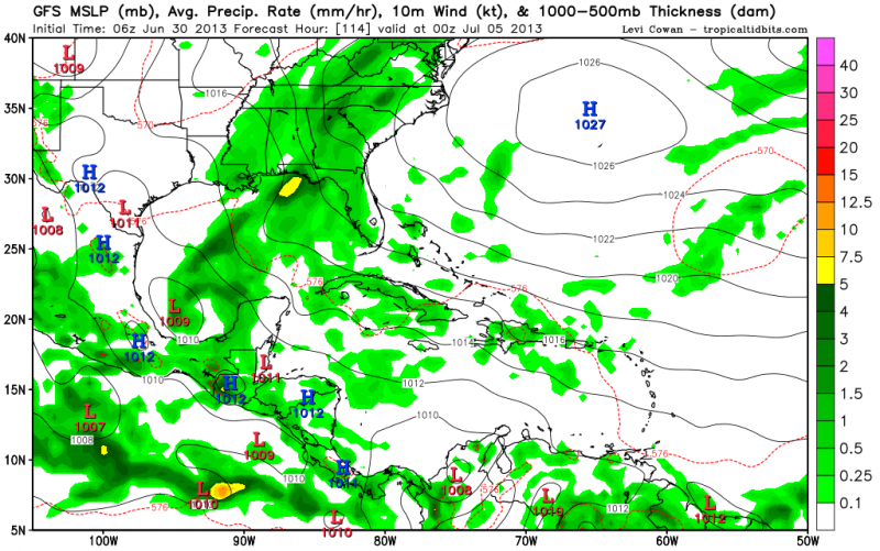
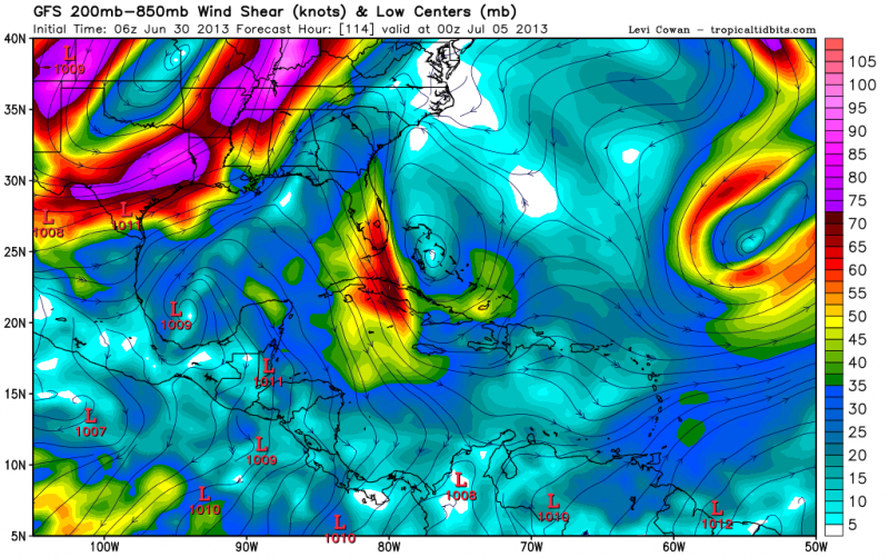
cycloneye wrote:The TUTT trough has to weaken and lift north to then allow things to turn favorable in MDR and Caribbean and in spite of the strong MJO pulse rolling thru the basin, none of the models are showing much enthusiasm about development through mid-July. The very long range CFS showing several developments in July are going down the drain and that is why long range forecasts are only for entertainment as mother nature rules and changes constantly. I think we may have to wait until late July to see things heat up. I voted for 2 in the July poll but maybe it may be only 1?


Hurricaneman wrote:cycloneye wrote:The TUTT trough has to weaken and lift north to then allow things to turn favorable in MDR and Caribbean and in spite of the strong MJO pulse rolling thru the basin, none of the models are showing much enthusiasm about development through mid-July. The very long range CFS showing several developments in July are going down the drain and that is why long range forecasts are only for entertainment as mother nature rules and changes constantly. I think we may have to wait until late July to see things heat up. I voted for 2 in the July poll but maybe it may be only 1?
2004 is the perfect analog due to 2004 having a similar MJO pulse for the atlantic at the same time as this year but having alot of shear basically in the same spot and it looks like ENSO 3-4 is warming up while ENSO 1-2 are staying cold so basically a possible El Nino Madoki which tends to lead to landfalls from Florida to Texas so this could get ugly when August comes
This also looks like it could be a big Cape Verde Season with these strong tropical waves already and the fact the shear is low from Africa to 45W, and the other semi favorable area is the BOC as of now so we'll see how that evolves, maybe the TUTT doesnt move much and leads to a much lesser season than everybody thought
sunnyday wrote:It seems as if we read of dire predictions of many, many storms most years prior to the beginning of the season. This year has been particularly that way. And now--is it looking like things won't go that way? Is it not going to be a terribly active year in spite of the discussions of the SST's, El Nino, etc.? Are we going to be fortunate again? We can hope...
Thank you for your opinions?


Users browsing this forum: No registered users and 46 guests


