ATL: DANNY - Models

Moderator: S2k Moderators

Message
Author
User avatar
TheProfessor
Professional-Met
Professional-Met
Posts: 3506
Age: 28
Joined: Tue Dec 03, 2013 10:56 am
Location: Wichita, Kansas

#561 Postby TheProfessor » Thu Aug 20, 2015 9:12 am

ConvergenceZone wrote:wxman, you are always here to rain on the parade, lol..... :wink:

(kidding of course,we love ya)


You get pretty used to him in the Texas thread during the winter. :lol:
0 likes   
An alumnus of The Ohio State University.

Your local National Weather Service office is your best source for weather information.

User avatar
blp
Category 5
Category 5
Posts: 2840
Age: 46
Joined: Thu Sep 09, 2004 7:51 pm
Location: Miami, FL
Contact:

Re: ATL: DANNY - Models

#562 Postby blp » Thu Aug 20, 2015 9:51 am

Question, what impact does the small size of this system have on the models being able handle it's strength and future track. I know years ago small systems like this where hard to handle by the models intensity and trackwise. They almost always depicted a shallower system or did not even show it well.
0 likes   
The following post is NOT an official forecast and should not be used as such. It is just the opinion of the poster and may or may not be backed by sound meteorological data. It is NOT endorsed by any professional institution including storm2k.org For Official Information please refer to the NHC and NWS products.

User avatar
SouthFLTropics
Category 5
Category 5
Posts: 4236
Age: 50
Joined: Thu Aug 14, 2003 8:04 am
Location: Port St. Lucie, Florida

#563 Postby SouthFLTropics » Thu Aug 20, 2015 10:18 am

GFS should be starting shortly...Will be very interesting to see what it and the Euro show today.
0 likes   
Fourth Generation Florida Native

Personal Storm History: David 79, Andrew 92, Erin 95, Floyd 99, Irene 99, Frances 04, Jeanne 04, Wilma 05, Matthew 16, Irma 17, Ian 22, Nicole 22, Milton 24

User avatar
Kohlecane
Category 2
Category 2
Posts: 593
Age: 33
Joined: Sun Jul 31, 2011 11:03 pm
Location: Beaufort, SC

Re: ATL: DANNY - Models

#564 Postby Kohlecane » Thu Aug 20, 2015 10:25 am

May i have a link too the models GFS Euro etc.. the one i did have is not working on my computer ATM. Thanks
0 likes   
Once I see the REDS and GREENS Converge on a Base Velocity. ... I'm There!!

This is NOT an Official Forecast....Just my Opinion. For official information, please refer to the NHC and NWS products.
HIGHLIGHTS : '13 El Reno Tornado : 2013 Storm Chaser Tour, Joaquin; SC flood event, Matthew '16, Lowcountry Snow storm Jan '18

Dean4Storms
S2K Supporter
S2K Supporter
Posts: 6358
Age: 62
Joined: Sun Aug 31, 2003 1:01 pm
Location: Miramar Bch. FL

Re: ATL: DANNY - Models

#565 Postby Dean4Storms » Thu Aug 20, 2015 10:27 am

Stormcenter wrote:Not to disagree with you but that's a week away, isn't safe to say a lot can change before then?


wxman57 wrote:Danny does, at least, look like a TS today. I was looking at the wind shear in its path a week from today, in case it had any ideas of coming toward the Gulf or East U.S. Coast. There should be a giant upper-level low in the Gulf and a wall of shear that would destroy anything moving toward it. The map below is valid next Thursday, about the time Danny would be near the Bahamas or Cuba. I think the models have it right - dissipation after it passes the NE Caribbean.

Image


That's a deep trough, don't know that I would bite on that yet.
0 likes   

Dean4Storms
S2K Supporter
S2K Supporter
Posts: 6358
Age: 62
Joined: Sun Aug 31, 2003 1:01 pm
Location: Miramar Bch. FL

#566 Postby Dean4Storms » Thu Aug 20, 2015 10:32 am

Looks like NHC is a tad on the southern side of most of the guidance coming into the Islands with the exception of the ECM most are further North. It wouldn't take much of a more than expected WNW path or NW from out where it is to miss the bigger Islands down the road once extrapolated.
0 likes   

User avatar
ronjon
Category 5
Category 5
Posts: 4822
Joined: Fri Aug 19, 2005 5:17 pm
Location: Hernando Beach, FL

Re: ATL: DANNY - Models

#567 Postby ronjon » Thu Aug 20, 2015 10:41 am

Models coming into pretty good consensus that whatever's left of Danny will be near S FL-Bahamas in about week from now. Drought buster for S FL?
Last edited by ronjon on Thu Aug 20, 2015 10:43 am, edited 2 times in total.
0 likes   

rockyman
Category 5
Category 5
Posts: 1967
Joined: Thu Jun 26, 2003 12:24 pm
Location: Dauphin Island, AL

Re: ATL: DANNY - Models

#568 Postby rockyman » Thu Aug 20, 2015 10:42 am

0 likes   

User avatar
beoumont
Category 1
Category 1
Posts: 473
Joined: Sun Jul 10, 2011 4:13 pm
Location: East Central Florida
Contact:

Re: ATL: DANNY - Models

#569 Postby beoumont » Thu Aug 20, 2015 10:49 am

South Texas Storms wrote:
caneman wrote:Some things never change with Rock and the Euro ;0

Joking aside. I believe the box to look for is 20 and 65, if it comes in South it would be a threat to the US. Further North is usually a miss. Forget the name of that box. Didn't someone at The Weather Channel come up with that? Someone can correct me if wrong.


That is the Hebert Box and he worked at the NWS and NHC.
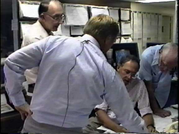

Paul Hebert (pronounce AY-bear with a French accent). I, and many others, consider him the most knowledged hurricane expert ever to work at the NHC. Many a time, the hurricane forecaster on duty, or director would turn to him for advise.

In the picture below shot as Hurricane Andrew was approaching Miami, Hebert is on the left, then Bob Sheets, Max Mayfield, and Gil Clark. They were deciding exactly which areas of coastline to issue warnings for.

Image
Last edited by beoumont on Thu Aug 20, 2015 11:01 am, edited 2 times in total.
0 likes   
List of 79 tropical cyclones intercepted by Richard Horodner:
http://www.canebeard.com/page/page/572246.htm

User avatar
Kohlecane
Category 2
Category 2
Posts: 593
Age: 33
Joined: Sun Jul 31, 2011 11:03 pm
Location: Beaufort, SC

Re: ATL: DANNY - Models

#570 Postby Kohlecane » Thu Aug 20, 2015 10:50 am

rockyman wrote:12z GFS is running. Follow it here:

http://www.tropicaltidbits.com/analysis ... 0&ypos=199

Yeah for some reason its not loading on my computer any other sites for modeling
0 likes   
Once I see the REDS and GREENS Converge on a Base Velocity. ... I'm There!!

This is NOT an Official Forecast....Just my Opinion. For official information, please refer to the NHC and NWS products.
HIGHLIGHTS : '13 El Reno Tornado : 2013 Storm Chaser Tour, Joaquin; SC flood event, Matthew '16, Lowcountry Snow storm Jan '18

User avatar
SouthFLTropics
Category 5
Category 5
Posts: 4236
Age: 50
Joined: Thu Aug 14, 2003 8:04 am
Location: Port St. Lucie, Florida

Re: ATL: DANNY - Models

#571 Postby SouthFLTropics » Thu Aug 20, 2015 10:52 am

By 69 hours it seems that the GFS is showing a weakening trend with Danny. That is prior to any land interaction.

SFT
0 likes   
Fourth Generation Florida Native

Personal Storm History: David 79, Andrew 92, Erin 95, Floyd 99, Irene 99, Frances 04, Jeanne 04, Wilma 05, Matthew 16, Irma 17, Ian 22, Nicole 22, Milton 24

rockyman
Category 5
Category 5
Posts: 1967
Joined: Thu Jun 26, 2003 12:24 pm
Location: Dauphin Island, AL

Re: ATL: DANNY - Models

#572 Postby rockyman » Thu Aug 20, 2015 10:53 am

Kohlecane wrote:
rockyman wrote:12z GFS is running. Follow it here:

http://www.tropicaltidbits.com/analysis ... 0&ypos=199

Yeah for some reason its not loading on my computer any other sites for modeling


http://www.instantweathermaps.com/GFS-p ... b&hour=072
0 likes   

User avatar
N2FSU
S2K Supporter
S2K Supporter
Posts: 1062
Joined: Thu Sep 04, 2003 2:04 pm
Location: Tallahassee, FL

Re: ATL: DANNY - Models

#573 Postby N2FSU » Thu Aug 20, 2015 10:53 am

Kohlecane wrote:
rockyman wrote:12z GFS is running. Follow it here:

http://www.tropicaltidbits.com/analysis ... 0&ypos=199

Yeah for some reason its not loading on my computer any other sites for modeling


http://www.instantweathermaps.com
0 likes   

OuterBanker
S2K Supporter
S2K Supporter
Posts: 1731
Joined: Wed Feb 26, 2003 10:53 am
Location: Nags Head, NC
Contact:

Re: ATL: DANNY - Models

#574 Postby OuterBanker » Thu Aug 20, 2015 10:58 am

I think king Euro has had a death match with DR/Haiti since it was first initialized.
0 likes   

User avatar
SouthFLTropics
Category 5
Category 5
Posts: 4236
Age: 50
Joined: Thu Aug 14, 2003 8:04 am
Location: Port St. Lucie, Florida

Re: ATL: DANNY - Models

#575 Postby SouthFLTropics » Thu Aug 20, 2015 10:58 am

Not much left by 87 hours...

Image
0 likes   
Fourth Generation Florida Native

Personal Storm History: David 79, Andrew 92, Erin 95, Floyd 99, Irene 99, Frances 04, Jeanne 04, Wilma 05, Matthew 16, Irma 17, Ian 22, Nicole 22, Milton 24

User avatar
Bocadude85
Category 5
Category 5
Posts: 2991
Age: 38
Joined: Mon Apr 18, 2005 2:20 pm
Location: Honolulu,Hi

Re: ATL: DANNY - Models

#576 Postby Bocadude85 » Thu Aug 20, 2015 11:16 am

Was the 12z GFS initialized with Danny as a hurricane?
0 likes   

NCSTORMMAN

Re: ATL: DANNY - Models

#577 Postby NCSTORMMAN » Thu Aug 20, 2015 11:16 am

Bocadude85 wrote:Was the 12z GFS initialized with Danny as a hurricane?


Nope and I still think the track will be wrong.
0 likes   

stormlover2013

Re: ATL: DANNY - Models

#578 Postby stormlover2013 » Thu Aug 20, 2015 11:21 am

Ridge looks strong strong, strenght won't matter with where it goes, ridge is strong
0 likes   

User avatar
gatorcane
S2K Supporter
S2K Supporter
Posts: 23691
Age: 47
Joined: Sun Mar 13, 2005 3:54 pm
Location: Boca Raton, FL

#579 Postby gatorcane » Thu Aug 20, 2015 11:41 am

It will be interesting to see how the global models handle such a tiny hurricane like this. They should be able to but it will put them to the test.
0 likes   

User avatar
Yellow Evan
Professional-Met
Professional-Met
Posts: 16143
Age: 27
Joined: Fri Jul 15, 2011 12:48 pm
Location: Henderson, Nevada/Honolulu, HI
Contact:

Re:

#580 Postby Yellow Evan » Thu Aug 20, 2015 11:44 am

gatorcane wrote:It will be interesting to see how the global models handle such a tiny hurricane like this. They should be able to but it will put them to the test.


Global models sometimes underestimate small hurricanes like this. Look at Hilda a few weeks ago for proof.
0 likes   


Return to “2015”

Who is online

Users browsing this forum: No registered users and 2 guests