ATL: ANA - Post-Tropical
Moderator: S2k Moderators
-
wxman57

- Moderator-Pro Met

- Posts: 23172
- Age: 68
- Joined: Sat Jun 21, 2003 8:06 pm
- Location: Houston, TX (southwest)
Re: ATL: INVEST 90L
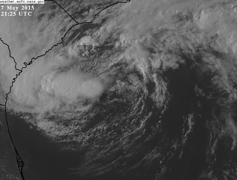
Surface low still to large & broad, and no convection near it. Needs to tighten-up and grow some squalls near the center to be classified as STS Ana.
0 likes
-
Evil Jeremy

- S2K Supporter

- Posts: 5463
- Age: 32
- Joined: Mon Apr 10, 2006 2:10 pm
- Location: Los Angeles, CA
Re: ATL: INVEST 90L
RL3AO wrote:I do like the fact they're using social media to inform people that a decision has been made instead of having us refresh the NHC page at 4:50 pm.
Or worse, setting their FTP page to auto-refresh for the renumber.
0 likes
Frances 04 / Jeanne 04 / Katrina 05 / Wilma 05 / Fay 08 / Debby 12 / Andrea 13 / Colin 16 / Hermine 16 / Matthew 16 / Irma 17

-
TheStormExpert
Re: ATL: INVEST 90L
Evil Jeremy wrote:RL3AO wrote:I do like the fact they're using social media to inform people that a decision has been made instead of having us refresh the NHC page at 4:50 pm.
Or worse, setting their FTP page to auto-refresh for the renumber.
Much better than frustratingly refreshing the NHC site questioning if they will upgrade.
0 likes

Re: ATL: INVEST 90L
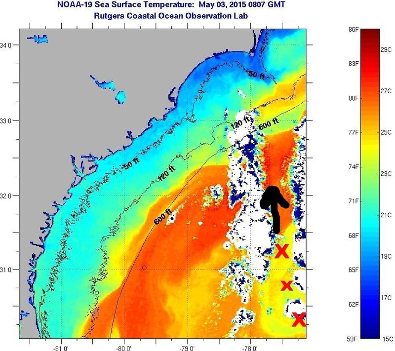
I would expect 90L to start getting better organized, convection wise, starting tonight through tomorrow as it will be tracking through the heart of the warm loop current with SSTs near 80. But I would expect that as quickly it starts moving away from the warm fuel over the weekend it will start loosing organization.
0 likes
-
Hypercane_Kyle

- Category 5

- Posts: 3465
- Joined: Sat Mar 07, 2015 7:58 pm
- Location: Cape Canaveral, FL
-
StarmanHDB

- Tropical Storm

- Posts: 202
- Age: 61
- Joined: Wed Sep 02, 2009 7:59 pm
- Location: West Palm Beach, Florida
Re: ATL: INVEST 90L
Yep, that center's bubbling rather nicely now. No denying it (well, based on vis sat and my highly underedumicated opinion)....Here comes Ana!
Last edited by StarmanHDB on Thu May 07, 2015 5:18 pm, edited 1 time in total.
0 likes
-
wxman57
- Moderator-Pro Met
- Posts: 23172
- Age: 68
- Joined: Sat Jun 21, 2003 8:06 pm
- Location: Houston, TX (southwest)
Re: ATL: INVEST 90L
Convection is still a bit west of the broad low center. lt also needs to be persistent.
0 likes
-
HurricaneTracker2031
- Tropical Storm
- Posts: 248
- Age: 26
- Joined: Fri Jul 19, 2013 7:20 pm
- Location: Pembroke Pines, FL, USA
- Contact:
Re: ATL: INVEST 90L
90L has convection firing near the center. However, it needs to be sustained and organize a little more. A few more hours is required to see it's fate.

Synopsis for 90L and other systems: http://goo.gl/BBRnSU
Personal Forecast Disclaimer:
The posts in this forum are NOT official forecast and should not be used as such. They are just the opinion of the poster and may or may not be backed by sound meteorological data. They are NOT endorsed by any professional institution or storm2k.org. For official information, please refer to the NHC and NWS products.
0 likes
SHORT VERSION OF DISCLAIMER: THIS SITE LINK BELOW IS NOT AN OFFICIAL FORECASTING OFFICE AND SHOULD NOT BE USED TO MAKE ANY EMERGENCY DECISIONS....
http://www.macstropicalweather.weebly.com
http://www.macstropicalweather.weebly.com
-
Ivanhater

- Storm2k Moderator

- Posts: 11221
- Age: 39
- Joined: Fri Jul 01, 2005 8:25 am
- Location: Pensacola
Re: ATL: INVEST 90L
The band well off to the north and east should detach over night and left with the low itself.
0 likes
Michael
-
SouthDadeFish

- Professional-Met

- Posts: 2835
- Joined: Thu Sep 23, 2010 2:54 pm
- Location: Miami, FL
- Contact:
Bob Hart's phase space suggests this system is symmetric warm-core, although it's pretty shallow. Interesting nonetheless. This suggests the transition to a fully tropical system may not be that far away.
http://moe.met.fsu.edu/cyclonephase/gfs ... 12/25.html
http://moe.met.fsu.edu/cyclonephase/gfs ... 12/25.html
0 likes
-
northjaxpro

- S2K Supporter
- Posts: 8900
- Joined: Mon Sep 27, 2010 11:21 am
- Location: Jacksonville, FL
Give it at least 6 hours from now and if the convection sustains itself near or around the center, NHC I believe will upgrade to STS Ana by 2 a.m. at the earliest. Interesting seeing the cloud deck coming into the Jax area moving south down the coast on the extreme western periphery of the circulation.
0 likes
NEVER, EVER SAY NEVER in the tropics and weather in general, and most importantly, with life itself!!
________________________________________________________________________________________
Fay 2008 Beryl 2012 Debby 2012 Colin 2016 Hermine 2016 Julia 2016 Matthew 2016 Irma 2017 Dorian 2019
________________________________________________________________________________________
Fay 2008 Beryl 2012 Debby 2012 Colin 2016 Hermine 2016 Julia 2016 Matthew 2016 Irma 2017 Dorian 2019
Who is online
Users browsing this forum: No registered users and 21 guests