Global model runs discussion
Moderator: S2k Moderators
-
northjaxpro

- S2K Supporter

- Posts: 8900
- Joined: Mon Sep 27, 2010 11:21 am
- Location: Jacksonville, FL
This is way, way out thankfully. But, one thing to take away from these runs by GFS is that there will probably be another trough in the vicinity of the U.S. East Coast within the next 10 days or so.
0 likes
NEVER, EVER SAY NEVER in the tropics and weather in general, and most importantly, with life itself!!
________________________________________________________________________________________
Fay 2008 Beryl 2012 Debby 2012 Colin 2016 Hermine 2016 Julia 2016 Matthew 2016 Irma 2017 Dorian 2019
________________________________________________________________________________________
Fay 2008 Beryl 2012 Debby 2012 Colin 2016 Hermine 2016 Julia 2016 Matthew 2016 Irma 2017 Dorian 2019

-
Hurricaneman

- Category 5

- Posts: 7404
- Age: 45
- Joined: Tue Aug 31, 2004 3:24 pm
- Location: central florida
Re:
gatorcane wrote:The FIM model is now picking up on WGOM development from something that originates from the SW Caribbean, like the ECMWF is showing. To the east is pouch 023L which is deepens rather quickly in the eastern tropical atlantic.
Levi Cowen mentioned something like this could happen in his video yesterday and it wouldn't be a surprise and another thing that says it may be possible is that it has model support
http://www.tropicaltidbits.com/blog/201 ... bal-exits/
The posts in this forum are NOT official forecast and should not be used as such. They are just the opinion of the poster and may or may not be backed by sound meteorological data. They are NOT endorsed by any professional institution or storm2k.org. For official information, please refer to the NHC and NWS products
0 likes
-
South Texas Storms

- Professional-Met

- Posts: 4255
- Joined: Thu Jun 24, 2010 12:28 am
- Location: Houston, TX
Re: Global Model Runs Discussion
0z GFS and CMC are both showing development in the BOC around early next week.
0 likes
-
Rgv20

- S2K Supporter
- Posts: 2466
- Age: 39
- Joined: Wed Jan 05, 2011 5:42 pm
- Location: Edinburg/McAllen Tx
Going to be interesting what the ECMWF shows tonight!
0zGFS forecast for Monday Night..
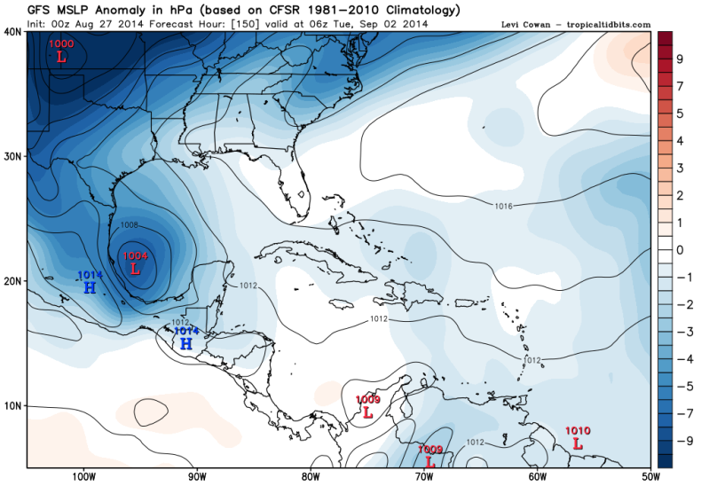
0zGFS Ensembles forecast for Monday Evening show lowering pressures in the SW Gulf/BOC..
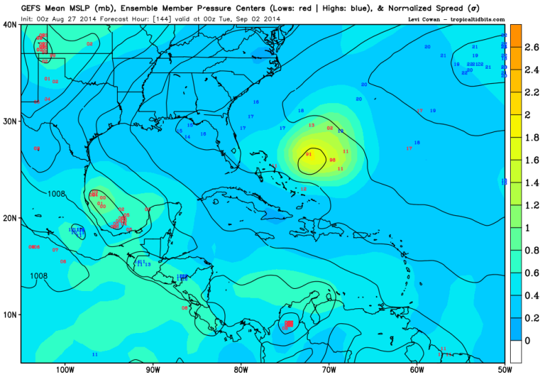
0zCMC forecast for Monday Night..
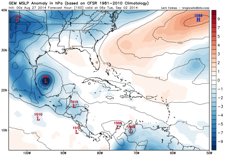
0zGFS forecast for Monday Night..

0zGFS Ensembles forecast for Monday Evening show lowering pressures in the SW Gulf/BOC..

0zCMC forecast for Monday Night..

0 likes
The following post is NOT an official forecast and should not be used as such. It is just the opinion of the poster and may or may not be backed by sound meteorological data. It is NOT endorsed by any professional institution including storm2k.org For Official Information please refer to the NHC and NWS products.
-
somethingfunny

- ChatStaff

- Posts: 3926
- Age: 37
- Joined: Thu May 31, 2007 10:30 pm
- Location: McKinney, Texas
Re: Global Model Runs Discussion
The 00z GFS looks very similar in the Bay of Campeche next week (and the Canadian may have a hurricane as it develops the system before crossing the Yucatan) but what really caught my eye was this final frame before the resolution drops on the GFS -- Look at that moisture plume for Texas!

0 likes
I am not a meteorologist, and any posts made by me are not official forecasts or to be interpreted as being intelligent. These posts are just my opinions and are probably silly opinions.

Re: Global Model Runs Discussion
There's a stormy area just south of Jamaica. Could that be the beginnings of the storm that's supposed to exit the sw Caribbean into the GOM?
0 likes
-
alienstorm

- Category 1

- Posts: 496
- Joined: Tue Jul 31, 2007 1:29 pm
- Location: Miami Fla western suburb
In all likelihood it will be ex-97L that comes into that area and adds the energy.
0 likes
Personal Forecast Disclaimer:The posts in this forum are NOT official forecast and should not be used as such. They are just the opinion of the poster and may or may not be backed by sound meteorological data. They are NOT endorsed by any professional institution or storm2k.org. For official information, please refer to the NHC and NWS products.
-
somethingfunny
- ChatStaff
- Posts: 3926
- Age: 37
- Joined: Thu May 31, 2007 10:30 pm
- Location: McKinney, Texas
Re: Global Model Runs Discussion
Yeah, up until now it's looked like 97L would track north of the islands and be an East Coast thing, and I'd thought that the Carib/Gulf potential for next week was another wave or a split-off lobe of 97L's. I guess we should slide over to the ex-97L thread with these Gulf storm model runs. 

0 likes
I am not a meteorologist, and any posts made by me are not official forecasts or to be interpreted as being intelligent. These posts are just my opinions and are probably silly opinions.
-
tropicwatch

- Category 5
- Posts: 3426
- Age: 62
- Joined: Sat Jun 02, 2007 10:01 am
- Location: Panama City Florida
- Contact:
Re: Global Model Runs Discussion
I think the models might be picking up this area just off of Yucatan.
http://weather.msfc.nasa.gov/cgi-bin/get-goes?satellite=GOES-E%20CONUS&lat=22&lon=-84&type=Animation&info=vis&numframes=10
http://weather.msfc.nasa.gov/cgi-bin/get-goes?satellite=GOES-E%20CONUS&lat=22&lon=-84&type=Animation&info=vis&numframes=10
0 likes
Tropicwatch
Agnes 72', Eloise 75, Elena 85', Kate 85', Charley 86', Florence 88', Beryl 94', Dean 95', Erin 95', Opal 95', Earl 98', Georges 98', Ivan 2004', Arlene 2005', Dennis 2005', Ida 2009' Debby 2012' Irma 2017' Michael 2018'
Agnes 72', Eloise 75, Elena 85', Kate 85', Charley 86', Florence 88', Beryl 94', Dean 95', Erin 95', Opal 95', Earl 98', Georges 98', Ivan 2004', Arlene 2005', Dennis 2005', Ida 2009' Debby 2012' Irma 2017' Michael 2018'
-
gatorcane

- S2K Supporter
- Posts: 23708
- Age: 48
- Joined: Sun Mar 13, 2005 3:54 pm
- Location: Boca Raton, FL
Well this would be quite the setup if this verified for Sept 12th - a class early to mid September long tracker Cape Verde system with with a ridge offshore the Carolinas  it forms from a wave that moves off Africa around 1 week from now...though we all know how awful the GFS has been in it's long-range genesis forecasts, but you never know if it gets one right eventually:


0 likes
-
gatorcane
- S2K Supporter
- Posts: 23708
- Age: 48
- Joined: Sun Mar 13, 2005 3:54 pm
- Location: Boca Raton, FL
All the 12Z Global model medium-range guidance (ECMWF/GFS/GEM/NAVGEM) show development of a Cape Verde wave in the Eastern Atlantic around 1 week from now. The cyclone moves west across the MDR in the long-range. Given the strong consensus, it looks like we may finally get something out there. Let's see what future model runs show for this wave.
0 likes
-
ninel conde
Re:
gatorcane wrote:All the 12Z Global model medium-range guidance (ECMWF/GFS/GEM/NAVGEM) show development of a Cape Verde wave in the Eastern Atlantic around 1 week from now. The cyclone moves west across the MDR in the long-range. Given the strong consensus, it looks like we may finally get something out there. Let's see what future model runs show for this wave.
you sure models show an actual developed cyclone moving west?
0 likes
-
ninel conde
-
ninel conde

Re:
ninel conde wrote:unless my map reading ability is lacking the euro at 10 days shows absolutely nothing.
http://moe.met.fsu.edu/cgi-bin/ecmwf-opertc2.cgi?time=2014083112&field=Sea+Level+Pressure&hour=120hr
http://mp1.met.psu.edu/~fxg1/ECMWFTROPATL0.5_12z/f120.gif
model shows a strong depression or storm off of Africa at 120 hours.
0 likes
The above post is not official and should not be used as such. It is the opinion of the poster and may or may not be backed by sound meteorological data. It is not endorsed by any professional institution or storm2k.org. For official information, please refer to the NHC and NWS products.
-
ninel conde
Re: Re:
Hammy wrote:ninel conde wrote:unless my map reading ability is lacking the euro at 10 days shows absolutely nothing.
http://moe.met.fsu.edu/cgi-bin/ecmwf-opertc2.cgi?time=2014083112&field=Sea+Level+Pressure&hour=120hr
http://mp1.met.psu.edu/~fxg1/ECMWFTROPATL0.5_12z/f120.gif
model shows a strong depression or storm off of Africa at 120 hours.
at day 10 it shows nothing that made it across
0 likes
Who is online
Users browsing this forum: No registered users and 49 guests