Not that it matters much but you still think this has a chance to reach named status before making landfall?
Conditions out there look worse than yesterday.
ATL: BILL - Post-Tropical
Moderator: S2k Moderators
-
CYCLONE MIKE
- Category 5

- Posts: 2183
- Joined: Tue Aug 31, 2004 6:04 pm
- Location: Gonzales, LA
Re: ATL: INVEST 91L - Discussion
0 likes

Re: ATL: INVEST 91L - Discussion
wxman57 wrote:cycloneye wrote:12z Best Track:
AL, 91, 2015061412, , BEST, 0, 205N, 890W, 30, 1008, DB
I think it's going to form much farther to the north, maybe 23 to 23.5N and 90W. This increases the threat farther east (into SW LA). Do a Google search of Allison in the Gulf 2001 and look at the image of Allison when it neared Galveston. Note where the center is within the cloud pattern. Look there for 91W in the satellite today.
Note that there may be a couple of low center at first - one farther south and one north where I'm looking. I think that the northern low will be the one to watch.
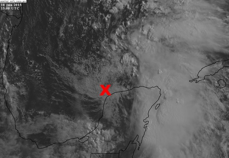
I see a weak low level vorticity/circulation near 21.2N & 90.5W
Which makes sense because Merida is reporting southerly winds this morning.
0 likes
-
wxman57

- Moderator-Pro Met

- Posts: 23172
- Age: 68
- Joined: Sat Jun 21, 2003 8:06 pm
- Location: Houston, TX (southwest)
Re: ATL: INVEST 91L - Discussion
CYCLONE MIKE wrote:Not that it matters much but you still think this has a chance to reach named status before making landfall?
Conditions out there look worse than yesterday.
I think that if it becomes a TD then there's about a 95% chance it will be upgraded to a TS, maybe higher.
NDG - I'm looking about 100 miles NNE of your red "X" on that satellite shot for where the circulation will focus later today. There may be 2 LLCs for a while, but the northern one should take over.
0 likes
Re: ATL: INVEST 91L - Discussion
wxman57 wrote:CYCLONE MIKE wrote:Not that it matters much but you still think this has a chance to reach named status before making landfall?
Conditions out there look worse than yesterday.
I think that if it becomes a TD then there's about a 95% chance it will be upgraded to a TS, maybe higher.
NDG - I'm looking about 100 miles NNE of your red "X" on that satellite shot for where the circulation will focus later today. There may be 2 LLCs for a while, but the northern one should take over.
I agree about possibly another circulation focusing NE of my X, I think the X is the old circulation from yesterday.
0 likes
-
stormlover2013
-
wxman57
- Moderator-Pro Met
- Posts: 23172
- Age: 68
- Joined: Sat Jun 21, 2003 8:06 pm
- Location: Houston, TX (southwest)
Re: ATL: INVEST 91L - Discussion
Unfortunately, I'm up in Chicago this weekend attending a wedding at noon today. I will be travelling tomorrow, getting home tomorrow evening. I may be able to access the internet while on the plane tomorrow afternoon.
0 likes
-
srainhoutx

- S2K Supporter

- Posts: 6919
- Age: 68
- Joined: Sun Jan 14, 2007 11:34 am
- Location: Haywood County, NC
- Contact:
Re: ATL: INVEST 91L - Discussion
wxman57 wrote:CYCLONE MIKE wrote:Not that it matters much but you still think this has a chance to reach named status before making landfall?
Conditions out there look worse than yesterday.
I think that if it becomes a TD then there's about a 95% chance it will be upgraded to a TS, maybe higher.
NDG - I'm looking about 100 miles NNE of your red "X" on that satellite shot for where the circulation will focus later today. There may be 2 LLCs for a while, but the northern one should take over.
HIRES visible imagery loop certainly agrees with that.
0 likes
Carla/Alicia/Jerry(In The Eye)/Michelle/Charley/Ivan/Dennis/Katrina/Rita/Wilma/Ike/Harvey
Member: National Weather Association
Wx Infinity Forums
http://wxinfinity.com/index.php
Facebook.com/WeatherInfinity
Twitter @WeatherInfinity
Member: National Weather Association
Wx Infinity Forums
http://wxinfinity.com/index.php
Facebook.com/WeatherInfinity
Twitter @WeatherInfinity
-
srainhoutx
- S2K Supporter
- Posts: 6919
- Age: 68
- Joined: Sun Jan 14, 2007 11:34 am
- Location: Haywood County, NC
- Contact:
Re: ATL: INVEST 91L - Discussion
Morning briefing from Jeff:
***Tropical system likely to impact the TX coast early this week.***
Dangerous amounts of rainfall expected leading to potentially widespread and significant flooding.
Discussion:
Air mass is moist and tropical this morning with PWS of 2.17 inches recorded at Lake Charles and radar show numerous showers and thunderstorms progressing inland off the Gulf of Mexico. Concentration of heavy rainfall is aimed at the areas north of Victoria to SE of Austin where training bands are in progress. Will have to keep a close eye on this as the radar suggest training bands attempting to setup over our western counties. Rainfall rates in this air mass will be 2-3 inches per hour and can quickly lead to flooding especially in urban areas.
91L:
System remains rather disorganized this morning as the sharp surface trough or elongated area of low pressure continues to interact with an upper level trough to its west. This upper trough is forecast to weaken and drift southwest while high pressure builds over the SE US. This will slowly result in more favorable conditions for tropical cyclone formation over the western Gulf of Mexico tonight-Tuesday.
Track:
91L will track generally NW toward the TX coast and this is support by all model guidance which are actually fairly tightly clustered with a landfall along the middle/upper TX coast on Tuesday. The exact track will be determined by the building ridge of high pressure over the SE US. It is interesting to note that a couple respectable models do slow and briefly stall the system near landfall on Tuesday, but at this time this appears to be an outlier solution.
Intensity:
There has been little change in the intensity guidance overnight with generally most models showing a weak tropical storm near landfall. Upper level conditions will gradually become more favorable for development as the system moves into the NW Gulf and upper level shear weakens. This does not appear to be a situation where rapid intensification is favored.
Impacts:
Main impact with be rainfall and potentially very significant amounts of rainfall. Potential is increasing for a dangerous flash flood event associated with the landfall of this system.
Rainfall:
Forecast models are in general agreement with excessive rainfall and an extremely moist air mass moving into the area Monday afternoon and evening as the northern feeder bands/rain shield approach the coast. PWS increase to 2.4-2.6 inches which is +2SD above normal and near record values for June. TS Allison values were near 2.4 inches…so this air mass will be very much capable of some really big rainfall totals. Training of feeder bands is worrying with SE TX likely falling on the eastern side of the circulation center. Hourly rainfall rates of 3-6 inches will be possible which will quickly lead to flash flooding.
WPC has already placed SE TX in a slight risk for heavy rainfall and this will likely be increased to a moderate or even high risk. Flash flood watches will be required.
Widespread rainfall amounts of 6-8 inches with isolated totals of 10-15 inches is the current thinking. Should the system slow or a period of sustained cell training develop…totals could easily top 20 inches.
This is a potentially very serious flash flood threat and areas that do not normally flood could flood which this type of rainfall.
Tides:
Tides are running .5-1.0 ft above normal this morning. Current water levels are running 2.0-2.4 ft total water along Bolivar and 2.2-2.6 ft total water level in Galveston Bay. Critical elevations are around 4.0 ft along the Gulf beaches and 4.0-5.0 ft in the bay. Increasing E to ESE winds will likely result in additional tidal and wave pile up along the upper TX coast. Will need to keep a close watch on tides as they could get into coastal flood warning criteria or around 4.0 ft above normal late Monday into Tuesday which would result in overwash of the western end of Galveston Island and Bolivar.
Winds:
Will not go much higher than 40-45mph across the coastal waters although stronger winds are possible in heavy thunderstorms and feeder bands. Worst of the weather will likely be removed to the east side of the center of circulation or across the SE TX waters into SW LA. Tropical storm force winds are possible if not likely across much of the coastal waters late Monday into Tuesday and across the coastal beaches and inland bays early Tuesday. Inland winds of 25-35mph can be expected.
Tornadoes:
The current forecast track place the center inland along the mid or upper TX coast between Corpus Christi and Galveston Bay. This places much of SE TX within the right front quaderant of the system which is most favorable for weak tornado production. Tornadoes tend to be most likely in the feeder bands and this will be possible with this system. Tornado threat will be increasing late Monday and last much of the day on Tuesday as bands move inland from the Gulf of Mexico. Such tornadoes tend to be weak…but can still cause damage.
Actions:
Residents along the middle and upper TX coast into SW LA should be preparing for the landfall of a tropical storm within the next 72 hours….with the main emphasis being on flooding.
Keep up to date on the latest weather forecasts as significant forecast changes will be possible over the next 48 hours.
0 likes
Carla/Alicia/Jerry(In The Eye)/Michelle/Charley/Ivan/Dennis/Katrina/Rita/Wilma/Ike/Harvey
Member: National Weather Association
Wx Infinity Forums
http://wxinfinity.com/index.php
Facebook.com/WeatherInfinity
Twitter @WeatherInfinity
Member: National Weather Association
Wx Infinity Forums
http://wxinfinity.com/index.php
Facebook.com/WeatherInfinity
Twitter @WeatherInfinity
-
Tireman4

- S2K Supporter
- Posts: 5903
- Age: 60
- Joined: Fri Jun 30, 2006 1:08 pm
- Location: Humble, Texas
- Contact:
Re: ATL: INVEST 91L - Discussion
wxman57 wrote:CYCLONE MIKE wrote:Not that it matters much but you still think this has a chance to reach named status before making landfall?
Conditions out there look worse than yesterday.
I think that if it becomes a TD then there's about a 95% chance it will be upgraded to a TS, maybe higher.
NDG - I'm looking about 100 miles NNE of your red "X" on that satellite shot for where the circulation will focus later today. There may be 2 LLCs for a while, but the northern one should take over.
I know I am late to the party. What did I miss? LOL/ All the good food is gone now? LOL//..No, what do you mean higher? Higher than a low end Tropical Storm, like what mid range? (50-60 mph)?
0 likes
-
wxman57
- Moderator-Pro Met
- Posts: 23172
- Age: 68
- Joined: Sat Jun 21, 2003 8:06 pm
- Location: Houston, TX (southwest)
Re: ATL: INVEST 91L - Discussion
By "higher" I meant higher than 95% chance of a TS. Hurricane chances look low (5% or less).
0 likes
Re: ATL: INVEST 91L - Discussion
Wxman...what potential rainfall impacts do you predict for my location...Brazos river less than 1/4 mile from my house...(Brazoria County)...i mean, weve had enuff rain as is...what a nightmare
0 likes
-
cycloneye

- Admin

- Posts: 149275
- Age: 69
- Joined: Thu Oct 10, 2002 10:54 am
- Location: San Juan, Puerto Rico
Re: ATL: INVEST 91L - Discussion
For now there is no low placed on the surface analysis. (12z)

0 likes
Visit the Caribbean-Central America Weather Thread where you can find at first post web cams,radars
and observations from Caribbean basin members Click Here
and observations from Caribbean basin members Click Here
Re: ATL: INVEST 91L - Discussion
As the day is going the sign of a vorticity is starting to show up north of the Yucatan's northern coast. Some low level clouds over the NW tip of the peninsula are starting to move from the SW to the NE.
0 likes

There's been a pretty good expansion westward over the last hour or so of some of the high cloud elements, would this be a sign the shear is decreasing or just something temporary due to convective bursting?
0 likes
The above post is not official and should not be used as such. It is the opinion of the poster and may or may not be backed by sound meteorological data. It is not endorsed by any professional institution or storm2k.org. For official information, please refer to the NHC and NWS products.
-
TeamPlayersBlue

- Category 5
- Posts: 3529
- Joined: Tue Feb 02, 2010 1:44 am
- Location: Denver/Applewood, CO
Now that im in the right thread.... Storm right now looks ragged. If it remains ragged today, im thinking decently strong TS, if it gets its act together, could spin up quickly
http://www.ssd.noaa.gov/goes/east/gmex/flash-rb.html
http://www.ssd.noaa.gov/goes/east/gmex/flash-rb.html
0 likes
Personal Forecast Disclaimer:
The posts in this forum are NOT official forecast and should not be used as such. They are just the opinion of the poster and may or may not be backed by sound meteorological data. They are NOT endorsed by any professional institution or storm2k.org. For official information, please refer to the NHC and NWS products.
The posts in this forum are NOT official forecast and should not be used as such. They are just the opinion of the poster and may or may not be backed by sound meteorological data. They are NOT endorsed by any professional institution or storm2k.org. For official information, please refer to the NHC and NWS products.
-
tropicwatch

- Category 5
- Posts: 3426
- Age: 62
- Joined: Sat Jun 02, 2007 10:01 am
- Location: Panama City Florida
- Contact:
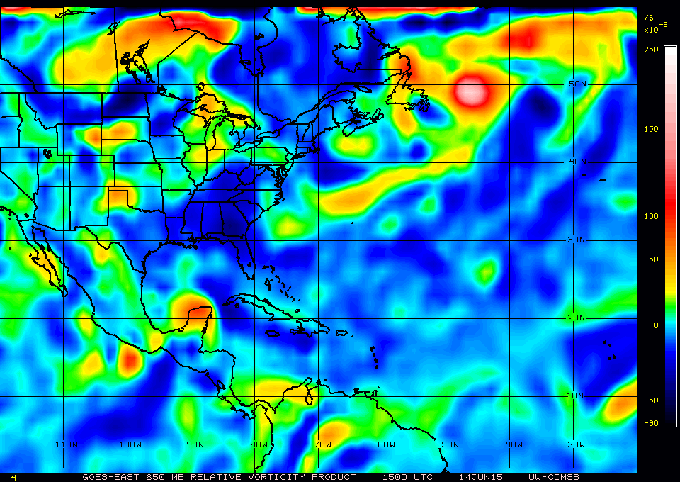
850mb vorticity:
0 likes
Tropicwatch
Agnes 72', Eloise 75, Elena 85', Kate 85', Charley 86', Florence 88', Beryl 94', Dean 95', Erin 95', Opal 95', Earl 98', Georges 98', Ivan 2004', Arlene 2005', Dennis 2005', Ida 2009' Debby 2012' Irma 2017' Michael 2018'
Agnes 72', Eloise 75, Elena 85', Kate 85', Charley 86', Florence 88', Beryl 94', Dean 95', Erin 95', Opal 95', Earl 98', Georges 98', Ivan 2004', Arlene 2005', Dennis 2005', Ida 2009' Debby 2012' Irma 2017' Michael 2018'


Re:
Hammy wrote:There's been a pretty good expansion westward over the last hour or so of some of the high cloud elements, would this be a sign the shear is decreasing or just something temporary due to convective bursting?
That, decreasing shear, and feeling the building southeast ridge. It will go the path of least resistance which is N and eventually NW as the high builds in. Convection will eventually do the same.
The strength of that ridge (is it hot in GA/Carolinas or what?) Determines where it landfalls be it mid texas coast or closer to upper Tx coast.
0 likes
The above post and any post by Ntxw is NOT an official forecast and should not be used as such. It is just the opinion of the poster and may or may not be backed by sound meteorological data. It is NOT endorsed by any professional institution including Storm2k. For official information, please refer to NWS products.
Help support Storm2K!

-
ConvergenceZone
.gif)
- Category 5
- Posts: 5241
- Joined: Fri Jul 29, 2005 1:40 am
- Location: Northern California
-
stormlover2013
Re: ATL: INVEST 91L - Discussion
Merida now reporting westerly winds, we have a closed low north of the peninsula.
Conditions at: MMMD (MERIDA INTL ARPT, MX) observed 1645 UTC 14 June 2015
Temperature: 32.0°C (90°F)
Dewpoint: 22.0°C (72°F) [RH = 56%]
Pressure (altimeter): 29.81 inches Hg (1009.6 mb)
Winds: from the W (270 degrees) at 10 MPH (9 knots; 4.7 m/s)
Visibility: 7 miles (11 km)
Ceiling: 2000 feet AGL
Clouds: broken clouds at 2000 feet AGL
Weather: no significant weather observed at this time
Last edited by NDG on Sun Jun 14, 2015 12:07 pm, edited 1 time in total.
0 likes
Who is online
Users browsing this forum: No registered users and 79 guests