I would say the JT is too aggressive this time.
TPPN10 PGTW 051225
A. TYPHOON 02W (NEPARTAK)
B. 05/1200Z
C. 17.17N
D. 133.45E
E. ONE/HMWRI8
F. T7.0/7.0/D4.0/24HRS STT: D1.0/03HRS
G. IR/EIR
H. REMARKS: /PBO . 10NM OW EYE SURROUNDED BY CMG YIELDS AN E# OF
6.5. ADDED 0.5 FOR EYE ADJUSTMENT TO YIELD A DT (NO BANDING) OF
7.0.
I. ADDITIONAL POSITIONS: NONE
HART
WPAC: NEPARTAK - Post-Tropical
Moderator: S2k Moderators
Re: WPAC: NEPARTAK - Typhoon
0 likes
Personal Forecast Disclaimer:
The posts in this forum are NOT official forecast and should not be used as such. They are just the opinion of the poster and may or may not be backed by sound meteorological data. They are NOT endorsed by any professional institution or storm2k.org. For official information, please refer to RSMC and NWS products.
The posts in this forum are NOT official forecast and should not be used as such. They are just the opinion of the poster and may or may not be backed by sound meteorological data. They are NOT endorsed by any professional institution or storm2k.org. For official information, please refer to RSMC and NWS products.
-
1900hurricane

- Category 5

- Posts: 6063
- Age: 34
- Joined: Fri Feb 06, 2015 12:04 pm
- Location: Houston, TX
- Contact:
Re: WPAC: NEPARTAK - Typhoon
The deepest red on this image correspond to white on Dvorák imagery, -70*C. Too bad there aren't any colder layers, but it's what we have right now.

0 likes
Contract Meteorologist. TAMU & MSST. Fiercely authentic, one of a kind. We are all given free will, so choose a life meant to be lived. We are the Masters of our own Stories.
Opinions expressed are mine alone.
Follow me on Twitter at @1900hurricane : Read blogs at https://1900hurricane.wordpress.com/
Opinions expressed are mine alone.
Follow me on Twitter at @1900hurricane : Read blogs at https://1900hurricane.wordpress.com/
-
stormwise
Re: WPAC: NEPARTAK - Typhoon
Big gravity waves moving over the cdo on animated sat beautiful site.
0 likes
-
1900hurricane
- Category 5
- Posts: 6063
- Age: 34
- Joined: Fri Feb 06, 2015 12:04 pm
- Location: Houston, TX
- Contact:
Re: WPAC: NEPARTAK - Typhoon
Microwave presentation is one of an intensifying storm.

0 likes
Contract Meteorologist. TAMU & MSST. Fiercely authentic, one of a kind. We are all given free will, so choose a life meant to be lived. We are the Masters of our own Stories.
Opinions expressed are mine alone.
Follow me on Twitter at @1900hurricane : Read blogs at https://1900hurricane.wordpress.com/
Opinions expressed are mine alone.
Follow me on Twitter at @1900hurricane : Read blogs at https://1900hurricane.wordpress.com/
-
1900hurricane
- Category 5
- Posts: 6063
- Age: 34
- Joined: Fri Feb 06, 2015 12:04 pm
- Location: Houston, TX
- Contact:
Re: WPAC: NEPARTAK - Typhoon
As of 12Z, JMA is up to 85 kt (CI 5.5) with strengthening forecasted to 100 kt (T 6.5) by hour 48.
0 likes
Contract Meteorologist. TAMU & MSST. Fiercely authentic, one of a kind. We are all given free will, so choose a life meant to be lived. We are the Masters of our own Stories.
Opinions expressed are mine alone.
Follow me on Twitter at @1900hurricane : Read blogs at https://1900hurricane.wordpress.com/
Opinions expressed are mine alone.
Follow me on Twitter at @1900hurricane : Read blogs at https://1900hurricane.wordpress.com/
Re: WPAC: NEPARTAK - Typhoon
JTWC seems to have neglected the T7.0 estimate and gone with 120 kt at 12Z.
02W NEPARTAK 160705 1200 17.2N 133.5E WPAC 120 933
02W NEPARTAK 160705 1200 17.2N 133.5E WPAC 120 933
0 likes
Personal Forecast Disclaimer:
The posts in this forum are NOT official forecast and should not be used as such. They are just the opinion of the poster and may or may not be backed by sound meteorological data. They are NOT endorsed by any professional institution or storm2k.org. For official information, please refer to RSMC and NWS products.
The posts in this forum are NOT official forecast and should not be used as such. They are just the opinion of the poster and may or may not be backed by sound meteorological data. They are NOT endorsed by any professional institution or storm2k.org. For official information, please refer to RSMC and NWS products.
-
1900hurricane
- Category 5
- Posts: 6063
- Age: 34
- Joined: Fri Feb 06, 2015 12:04 pm
- Location: Houston, TX
- Contact:
Re: WPAC: NEPARTAK - Typhoon
They'll probably site SSD's 6.0 and rapid increases in T# and then say they're going with a blend, which is fine with me. Even when breaking constraints, a jump from 85 kt (which admittedly was likely a little low) to 130-140 kt in one advisory is just way too much. Not even Wilma/Haiyan/Parricia did stuff quite like that.
0 likes
Contract Meteorologist. TAMU & MSST. Fiercely authentic, one of a kind. We are all given free will, so choose a life meant to be lived. We are the Masters of our own Stories.
Opinions expressed are mine alone.
Follow me on Twitter at @1900hurricane : Read blogs at https://1900hurricane.wordpress.com/
Opinions expressed are mine alone.
Follow me on Twitter at @1900hurricane : Read blogs at https://1900hurricane.wordpress.com/
-
1900hurricane
- Category 5
- Posts: 6063
- Age: 34
- Joined: Fri Feb 06, 2015 12:04 pm
- Location: Houston, TX
- Contact:
Re: WPAC: NEPARTAK - Typhoon
One thing I really do miss is ADT for eye temp read outs.
1 likes
Contract Meteorologist. TAMU & MSST. Fiercely authentic, one of a kind. We are all given free will, so choose a life meant to be lived. We are the Masters of our own Stories.
Opinions expressed are mine alone.
Follow me on Twitter at @1900hurricane : Read blogs at https://1900hurricane.wordpress.com/
Opinions expressed are mine alone.
Follow me on Twitter at @1900hurricane : Read blogs at https://1900hurricane.wordpress.com/
-
1900hurricane
- Category 5
- Posts: 6063
- Age: 34
- Joined: Fri Feb 06, 2015 12:04 pm
- Location: Houston, TX
- Contact:
Re: WPAC: NEPARTAK - Typhoon
Just found an up to date image on the BD curve from FNMOC. Dang...

0 likes
Contract Meteorologist. TAMU & MSST. Fiercely authentic, one of a kind. We are all given free will, so choose a life meant to be lived. We are the Masters of our own Stories.
Opinions expressed are mine alone.
Follow me on Twitter at @1900hurricane : Read blogs at https://1900hurricane.wordpress.com/
Opinions expressed are mine alone.
Follow me on Twitter at @1900hurricane : Read blogs at https://1900hurricane.wordpress.com/

Re: WPAC: NEPARTAK - Typhoon
Satellite imagery is available again on SSD and RAMMB websites.
Btw, the BD imagery on FNMOC seems a bit abnormal to me.
Btw, the BD imagery on FNMOC seems a bit abnormal to me.
0 likes
Personal Forecast Disclaimer:
The posts in this forum are NOT official forecast and should not be used as such. They are just the opinion of the poster and may or may not be backed by sound meteorological data. They are NOT endorsed by any professional institution or storm2k.org. For official information, please refer to RSMC and NWS products.
The posts in this forum are NOT official forecast and should not be used as such. They are just the opinion of the poster and may or may not be backed by sound meteorological data. They are NOT endorsed by any professional institution or storm2k.org. For official information, please refer to RSMC and NWS products.
-
mrbagyo

- Category 5
- Posts: 3963
- Age: 33
- Joined: Thu Apr 12, 2012 9:18 am
- Location: 14.13N 120.98E
- Contact:
Re: WPAC: NEPARTAK - Typhoon
1900hurricane wrote:Just found an up to date image on the BD curve from FNMOC. Dang...
That's a very tight core, must be approaching super level if not already.
I think this might peak sooner than forecast
Dave C wrote:This has an incredible outflow channel to the north!
Must been enhanced by a TUTT cell. Too bad we cant view the pacific wide water vapor imagery.. what's up with ssd?
0 likes
The posts in this forum are NOT official forecast and should not be used as such. They are just the opinion of the poster and may or may not be backed by sound meteorological data. They are NOT endorsed by any professional institution or storm2k.org. For official information, please refer to RSMC, NHC and NWS products.
-
1900hurricane
- Category 5
- Posts: 6063
- Age: 34
- Joined: Fri Feb 06, 2015 12:04 pm
- Location: Houston, TX
- Contact:
Re: WPAC: NEPARTAK - Typhoon
Yep, looks to be running a little cold compared to the ones that just came back online.
0 likes
Contract Meteorologist. TAMU & MSST. Fiercely authentic, one of a kind. We are all given free will, so choose a life meant to be lived. We are the Masters of our own Stories.
Opinions expressed are mine alone.
Follow me on Twitter at @1900hurricane : Read blogs at https://1900hurricane.wordpress.com/
Opinions expressed are mine alone.
Follow me on Twitter at @1900hurricane : Read blogs at https://1900hurricane.wordpress.com/
-
1900hurricane
- Category 5
- Posts: 6063
- Age: 34
- Joined: Fri Feb 06, 2015 12:04 pm
- Location: Houston, TX
- Contact:
Re: WPAC: NEPARTAK - Typhoon
Nepartak's environment was pinpointed as quite a favorable one a few days ago, and conditions have not disappointed.

0 likes
Contract Meteorologist. TAMU & MSST. Fiercely authentic, one of a kind. We are all given free will, so choose a life meant to be lived. We are the Masters of our own Stories.
Opinions expressed are mine alone.
Follow me on Twitter at @1900hurricane : Read blogs at https://1900hurricane.wordpress.com/
Opinions expressed are mine alone.
Follow me on Twitter at @1900hurricane : Read blogs at https://1900hurricane.wordpress.com/
-
1900hurricane
- Category 5
- Posts: 6063
- Age: 34
- Joined: Fri Feb 06, 2015 12:04 pm
- Location: Houston, TX
- Contact:
Re: WPAC: NEPARTAK - Typhoon
JTWC forecasting 140 kt within 24 hours.
WDPN31 PGTW 051500
MSGID/GENADMIN/JOINT TYPHOON WRNCEN PEARL HARBOR HI//
SUBJ/PROGNOSTIC REASONING FOR TYPHOON 02W (NEPARTAK)
WARNING NR 11//
RMKS//
1. FOR METEOROLOGISTS.
2. 6 HOUR SUMMARY AND ANALYSIS.
TYPHOON 02W (NEPARTAK), LOCATED APPROXIMATELY 821 NM EAST-
SOUTHEAST OF TAIPEI, TAIWAN, HAS TRACKED WEST-NORTHWESTWARD AT 18
KNOTS OVER THE PAST SIX HOURS. THE CURRENT POSITION IS BASED, WITH
HIGH CONFIDENCE, ON SATELLITE EYE FIXES FROM PGTW AND RJTD. RECENT
DVORAK SATELLITE INTENSITY ESTIMATES FROM PGTW, KNES, AND RJTD
INDICATE THAT TY 02W HAS UNDERGONE VERY RAPID INTENSIFICATION OVER
THE PAST SIX HOURS, TO A CURRENT ESTIMATED INTENSITY OF 120 KNOTS.
PASSAGE OVER VERY WARM WATER, LOW VERTICAL WIND SHEAR, AND FAVORABLE
OUTFLOW ENHANCED BY AN UPPER-LEVEL TROUGH TO THE NORTHWEST ARE
SUPPORTING THE RAPID INTENSIFICATION TREND. TY 02W CONTINUES TO
TRACK QUICKLY NORTHWESTWARD ALONG THE PERIPHERY OF AN EXTENSIVE DEEP-
LAYERED SUBTROPICAL STEERING RIDGE.
3. FORECAST REASONING.
A. FORECAST INTENSITIES HAVE BEEN INCREASED IN THE NEAR-TERM
BASED ON THE OBSERVED RATE OF RAPID INTENSIFICATION.
B. TY 02W IS EXPECTED TO CONTINUE TRACKING GENERALLY
NORTHWESTWARD TOWARD TAIWAN ALONG THE PERIPHERY OF THE SUBTROPICAL
STEERING RIDGE OVER THE NEXT 48 HOURS. STEADY TO RAPID
INTENSIFICATION IS ANTICIPATED IN THE NEAR-TERM AS ENVIRONMENTAL
CONDITIONS REMAIN FAVORABLE. SOME WEAKENING MAY OCCUR PRIOR TO
LANDFALL AS OUTFLOW DECREASES IN RESPONSE TO CHANGES IN THE UPPER-
LEVEL FLOW PATTERN. BY TAU 72, TY 02W WILL BEGIN TO ROUND THE
STEERING RIDGE PERIPHERY AND WEAKEN FURTHER DUE TO LAND INTERACTION.
NUMERICAL MODEL GUIDANCE REMAINS IN GOOD AGREEMENT WITH THE OVERALL
FORECAST SCENARIO WITHIN THE 72 HOUR FORECAST PERIOD, LENDING HIGH
CONFIDENCE TO THAT PORTION OF THE TRACK FORECAST.
C. IN THE EXTENDED PERIOD, TY 02W IS EXPECTED TO ROUND THE
STEERING RIDGE AXIS AND TRACK POLEWARD OVER THE EASTERN COAST OF
CHINA. LAND INTERACTION, INCREASING VERTICAL WIND SHEAR, AND PASSAGE
OVER COOLER WATER WILL RESULT IN STEADY WEAKENING DURING THIS
PERIOD. NUMERICAL MODELS ARE IN GOOD AGREEMENT REGARDING THE OVERALL
FORECAST SCENARIO, ALTHOUGH THERE REMAINS SIGNIFICANT SPREAD IN THE
LOCATION AND TIMING OF THE TRACK AROUND THE RIDGE PERIPHERY. GIVEN
THIS SPREAD IN THE EXTENDED PERIOD, THERE IS LOW CONFIDENCE IN THE
EXTENDED FORECAST TRACK.//
NNNN
0 likes
Contract Meteorologist. TAMU & MSST. Fiercely authentic, one of a kind. We are all given free will, so choose a life meant to be lived. We are the Masters of our own Stories.
Opinions expressed are mine alone.
Follow me on Twitter at @1900hurricane : Read blogs at https://1900hurricane.wordpress.com/
Opinions expressed are mine alone.
Follow me on Twitter at @1900hurricane : Read blogs at https://1900hurricane.wordpress.com/
Re: WPAC: NEPARTAK - Typhoon
Very reasonable fix from SSD.
TXPQ28 KNES 051510
TCSWNP
A. 02W (NEPARTAK)
B. 05/1430Z
C. 17.5N
D. 132.8E
E. ONE/XXXX
F. T6.5/6.5/D2.5/24HRS
G. IR/EIR
H. REMARKS...PINHOLE OW EYE IS EMBEDDED IN...AND SURROUNDED BY...CMG
RESULTING IN A DT OF 7.0 AFTER 0.5 IS ADDED AS AN EYE ADJUSTMENT. HOWEVER,
THE AVERAGE DT CALCULATED HOURLY FOR THE 6 HOURS ENDING AT 1430Z WAS
6.5, WHICH DOES NOT JUSTIFY BREAKING DVORAK CONSTRAINTS ATTM. PT IS 6.0
WHILE MET IS 5.5 BASED ON RAPID DEVELOPMENT OVER THE LAST 24 HOURS. FT
IS BASED ON CONSTRAINTS LIMITING CHANGES IN FT TO 1.5 IN 12 HRS.
I. ADDL POSITIONS
NIL
...TURK
0 likes
Personal Forecast Disclaimer:
The posts in this forum are NOT official forecast and should not be used as such. They are just the opinion of the poster and may or may not be backed by sound meteorological data. They are NOT endorsed by any professional institution or storm2k.org. For official information, please refer to RSMC and NWS products.
The posts in this forum are NOT official forecast and should not be used as such. They are just the opinion of the poster and may or may not be backed by sound meteorological data. They are NOT endorsed by any professional institution or storm2k.org. For official information, please refer to RSMC and NWS products.
-
Yellow Evan

- Professional-Met

- Posts: 16222
- Age: 27
- Joined: Fri Jul 15, 2011 12:48 pm
- Location: Henderson, Nevada/Honolulu, HI
- Contact:
Re: WPAC: NEPARTAK - Typhoon
In terms of actual intensity, I'd estimate around 135 knots now.
0 likes
Re: WPAC: NEPARTAK - Typhoon
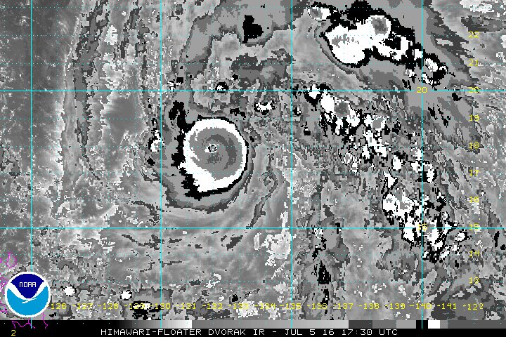
2016JUL05 173000 5.7 950.0 107.2 5.7 5.7 7.1 1.3T/6hr OFF OFF 17.45 -78.18 EYE 11 IR 57.4 17.93 -131.98 COMBO HIM-8 23.4
Looks like a typical category 5 now. Personally I would go with 145 kt at 18Z. Would like to see the WMG eye persist before going higher.
0 likes
Personal Forecast Disclaimer:
The posts in this forum are NOT official forecast and should not be used as such. They are just the opinion of the poster and may or may not be backed by sound meteorological data. They are NOT endorsed by any professional institution or storm2k.org. For official information, please refer to RSMC and NWS products.
The posts in this forum are NOT official forecast and should not be used as such. They are just the opinion of the poster and may or may not be backed by sound meteorological data. They are NOT endorsed by any professional institution or storm2k.org. For official information, please refer to RSMC and NWS products.
Who is online
Users browsing this forum: No registered users and 12 guests