ATL: EARL - Remnants - Discussion
Moderator: S2k Moderators

Re: ATL: INVEST 97L - Models
The reason why the CMC is not developing 97L is because it has it as an elongated E-W vorticity initially and it forecasts a high shear zone over the western Caribbean to stay in place, shredding it to pieces, contradicting the GFS and Euro which show good UL winds over the western Caribbean.
0 likes
Re: ATL: INVEST 97L - Models
PTrackerLA wrote:Starting to look like the typical cross Yucatan and straight across the BOC into Mexico track we have seen so many times over the past 10 years. Ridge looks firmly entrenched over the northern Gulf coast.
TX is no way out of the woods yet, sypnotics pattern can still give a hard time to forecast right by the models in the 5-7 day range.
1 likes

Re: ATL: INVEST 97L - Models
PTrackerLA wrote:Starting to look like the typical cross Yucatan and straight across the BOC into Mexico track we have seen so many times over the past 10 years. Ridge looks firmly entrenched over the northern Gulf coast.
This is what I was thinking.
0 likes


Re: ATL: INVEST 97L - Discussion
If the ant-cyclone can stay overhead, it could help 97L get through the shear ahead of it (or unless it lessens before it gets there).
Last edited by JaxGator on Sat Jul 30, 2016 12:12 pm, edited 1 time in total.
1 likes
The posts or stuff said are NOT an official forecast. Please look to the NHC and NWS for official forecasts and products.
Floyd-1999, Frances-2004, Jeanne-2004, Fay-2008, Beryl-2012, Debby-2012, Colin-2016, Hermine-2016, Julia-2016, Matthew-2016, Irma-2017, Elsa-2021, Idalia-2023, Debby-2024, Helene-2024.
Go Gators! Go Jags!
Floyd-1999, Frances-2004, Jeanne-2004, Fay-2008, Beryl-2012, Debby-2012, Colin-2016, Hermine-2016, Julia-2016, Matthew-2016, Irma-2017, Elsa-2021, Idalia-2023, Debby-2024, Helene-2024.
Go Gators! Go Jags!
-
tarheelprogrammer

- S2K Supporter

- Posts: 1793
- Joined: Mon Mar 28, 2016 9:25 pm
- Location: Raleigh, NC area (Garner, NC)
Re: ATL: INVEST 97L - Discussion
Good link here to view 97L:
http://rammb.cira.colostate.edu/ramsdis/online/loop.asp?data_folder=tropical/tropical_ge_4km_visir2_floater_1&width=640&height=480&number_of_images_to_display=12
http://rammb.cira.colostate.edu/ramsdis/online/loop.asp?data_folder=tropical/tropical_ge_4km_visir2_floater_1&width=640&height=480&number_of_images_to_display=12
0 likes
My posts are not official forecasts. They are just my opinion and may or may not be backed by sound meteorological data. They are NOT endorsed by any professional institution or storm2k.org. For official information, please refer to the NHC and NWS products.
Re: ATL: INVEST 97L - Discussion
TheStormExpert wrote:JaxGator wrote:And recon is not going in today. For now anyway.
WEATHER RECONNAISSANCE FLIGHTS
CARCAH, NATIONAL HURRICANE CENTER, MIAMI, FL.
1015 AM EDT SAT 30 JULY 2016
SUBJECT: TROPICAL CYCLONE PLAN OF THE DAY (TCPOD)
VALID 31/1100Z TO 01/1100Z AUGUST 2016
TCPOD NUMBER.....16-065
I. ATLANTIC REQUIREMENTS
1. NEGATIVE RECONNAISSANCE REQUIREMENTS.
2. OUTLOOK FOR SUCCEEDING DAY.....NEGATIVE.
With the foward speed it's moving recon would have a tough time keeping up with 97L!
https://twitter.com/tropicaltidbits/status/759401751262924800
Maybe. It would probably be a wild goose chase.
0 likes
The posts or stuff said are NOT an official forecast. Please look to the NHC and NWS for official forecasts and products.
Floyd-1999, Frances-2004, Jeanne-2004, Fay-2008, Beryl-2012, Debby-2012, Colin-2016, Hermine-2016, Julia-2016, Matthew-2016, Irma-2017, Elsa-2021, Idalia-2023, Debby-2024, Helene-2024.
Go Gators! Go Jags!
Floyd-1999, Frances-2004, Jeanne-2004, Fay-2008, Beryl-2012, Debby-2012, Colin-2016, Hermine-2016, Julia-2016, Matthew-2016, Irma-2017, Elsa-2021, Idalia-2023, Debby-2024, Helene-2024.
Go Gators! Go Jags!
-
Huckster

- Category 1

- Posts: 394
- Age: 43
- Joined: Fri Aug 13, 2004 2:33 am
- Location: Baton Rouge, LA
- Contact:
Re: ATL: INVEST 97L - Models
PTrackerLA wrote:Starting to look like the typical cross Yucatan and straight across the BOC into Mexico track we have seen so many times over the past 10 years. Ridge looks firmly entrenched over the northern Gulf coast.
That is a fairly typical track for this time of year. Before August 10th or so, based on climatology, TX and Mexico are at a much higher risk than LA and points east, especially for hurricane hits.
2 likes
God lufode middaneard swa þæt he sealde his ancennedan Sunu, þæt nan ne forwurðe þe on hine gelyfð, ac hæbbe þæt ece lif. - Old English/Anglo-Saxon, John 3:16
Re: ATL: INVEST 97L - Discussion
H85 divergence is running below average over the Caribbean, so 97L should have no problem at all tracking across the eastern and central Caribbean, especially if it tracks north the of the 15th latitude away from the stronger h85 trade winds. IMO.
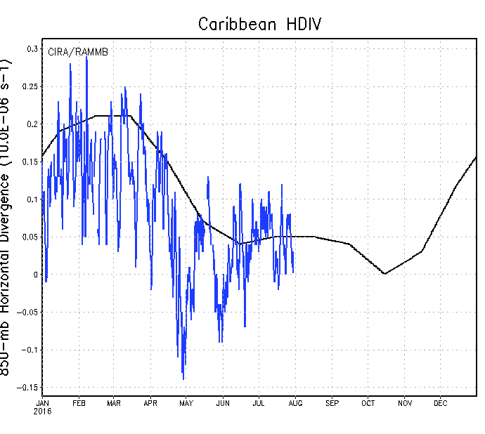
Trades have also been slightly below average across the Caribbean during the past 7 days.


Trades have also been slightly below average across the Caribbean during the past 7 days.

0 likes
-
gatorcane

- S2K Supporter
- Posts: 23708
- Age: 48
- Joined: Sun Mar 13, 2005 3:54 pm
- Location: Boca Raton, FL
Re: ATL: INVEST 97L - Models
12Z HWRF MUCH stronger through hour 57 and a little more north in the Caribbean

Last edited by gatorcane on Sat Jul 30, 2016 12:22 pm, edited 1 time in total.
1 likes
-
TheStormExpert
Re: ATL: INVEST 97L - Models
Most recent 12z Model Guidance and GEFS Ensembles. Also on the intensity guidance the IVCN(Lime-Green line) has 97L peaking at Cat.1 intensity now, the NHC closely follows that particular model when making their intensity forecasts for anyone who wasn't aware.


0 likes
-
AtlanticWind

- S2K Supporter
- Posts: 1898
- Age: 67
- Joined: Sun Aug 08, 2004 9:57 pm
- Location: Plantation,Fla
Re: ATL: INVEST 97L - Models
Still think this may end up a little further north than the models are indicating right now
just based on where a circulation may be forming.
[Disclaimer]Not a professional Met
just based on where a circulation may be forming.
[Disclaimer]Not a professional Met
1 likes
-
TheStormExpert
-
gatorcane
- S2K Supporter
- Posts: 23708
- Age: 48
- Joined: Sun Mar 13, 2005 3:54 pm
- Location: Boca Raton, FL
Re: ATL: INVEST 97L - Discussion
30/60

A strong tropical wave located about 550 miles east of the Lesser
Antilles is moving westward at 25 to 30 mph and is accompanied by
increasing shower activity. However, surface observations and
satellite wind data show that pressures are relatively high in the
area and that there are no signs of a circulation. During the next
day or two, development should be slow to occur due to the rapid
motion of the system. Regardless of development, this system will
likely bring locally heavy rains and gusty winds to portions of the
Leeward Islands, Virgin Islands, Puerto Rico, and Hispaniola, and
interests in these areas should monitor its progress. By the middle
of next week, the disturbance is expected to be in the western
Caribbean Sea, where conditions are likely to be more conducive for
development.
* Formation chance through 48 hours...low...30 percent
* Formation chance through 5 days...medium...60 percent
0 likes

Re: ATL: INVEST 97L - Models
NDG wrote:PTrackerLA wrote:Starting to look like the typical cross Yucatan and straight across the BOC into Mexico track we have seen so many times over the past 10 years. Ridge looks firmly entrenched over the northern Gulf coast.
TX is no way out of the woods yet, sypnotics pattern can still give a hard time to forecast right by the models in the 5-7 day range.
HWRF has a much stronger system now.
That means more outflow may change the upper air forecast.
For example often an ULL will get trapped over Mexico and either shear apart a weak following system, or fill as it vents a stronger systems outflow.
WXman57 is the 5 to 7 day expert, hopefully he will keep us updated.
Last edited by Nimbus on Sat Jul 30, 2016 12:49 pm, edited 1 time in total.
0 likes

Re: ATL: INVEST 97L - Models
NDG wrote:PTrackerLA wrote:Starting to look like the typical cross Yucatan and straight across the BOC into Mexico track we have seen so many times over the past 10 years. Ridge looks firmly entrenched over the northern Gulf coast.
TX is no way out of the woods yet, sypnotics pattern can still give a hard time to forecast right by the models in the 5-7 day range.
Agreed how many times have we seen the models flip flop especially in a 5 to 8 day range.
0 likes
-
xcool22
Re: ATL: INVEST 97L - Models
PTrackerLA wrote:Starting to look like the typical cross Yucatan and straight across the BOC into Mexico track we have seen so many times over the past 10 years. Ridge looks firmly entrenched over the northern Gulf coast.
yep I agree with you
0 likes
-
TheStormExpert


-
Gustywind

- Category 5

- Posts: 12334
- Joined: Mon Sep 03, 2007 7:29 am
- Location: Baie-Mahault, GUADELOUPE
Re: ATL: INVEST 97L - Discussion
Increasing numbers for the 97L up to 1.5/1.5. Moving straight west. This system is becoming much organized than yestarday at the same time.
DATE/TIME LAT LON CLASSIFICATION STORM
30/1745 UTC 14.8N 54.5W T1.5/1.5 97L
30/1145 UTC 14.8N 52.8W T1.0/1.0 97L
DATE/TIME LAT LON CLASSIFICATION STORM
30/1745 UTC 14.8N 54.5W T1.5/1.5 97L
30/1145 UTC 14.8N 52.8W T1.0/1.0 97L
0 likes
-
TheStormExpert
Re: ATL: INVEST 97L - Models
12z Euro @ 120hrs. with a 1009mb low just off the Belize coast.


0 likes
Who is online
Users browsing this forum: No registered users and 92 guests