ATL: EARL - Remnants - Discussion

Moderator: S2k Moderators

Message
Author
User avatar
Gustywind
Category 5
Category 5
Posts: 12334
Joined: Mon Sep 03, 2007 7:29 am
Location: Baie-Mahault, GUADELOUPE

Re: ATL: INVEST 97L - Discussion

#221 Postby Gustywind » Sat Jul 30, 2016 1:29 pm

abajan wrote:
Gustywind wrote:More passing lines of showers continue to spread on us. Seems that it's only a first round because of the most of the heavy patches of showers tstorms are scheluded for tonight and especially tommorow. Healthy 97L is approaching Guadeloupe, be sure about that. I will keep your informed as usual.
Gustywind.
Thanks for the updates, Gusty! Much appreciated. 8-)

No problem Abajan my friend :) ! We continue to monitor closely this strong twave.
0 likes   

TheStormExpert

Re: ATL: INVEST 97L - Models

#222 Postby TheStormExpert » Sat Jul 30, 2016 1:30 pm

1008mb low @ 144hrs. in the middle of the BoC.

Image

Image
0 likes   

User avatar
Rgv20
S2K Supporter
S2K Supporter
Posts: 2466
Age: 38
Joined: Wed Jan 05, 2011 5:42 pm
Location: Edinburg/McAllen Tx

Re: ATL: INVEST 97L - Models

#223 Postby Rgv20 » Sat Jul 30, 2016 1:31 pm

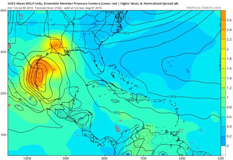
12zGFS Ensemble by Day 9 have 97L somewhere between Tampico and South Texas...will be interesting what the ECMWF Ensembles show!

Image
0 likes   
The following post is NOT an official forecast and should not be used as such. It is just the opinion of the poster and may or may not be backed by sound meteorological data. It is NOT endorsed by any professional institution including storm2k.org For Official Information please refer to the NHC and NWS products.

User avatar
Siker
Category 4
Category 4
Posts: 904
Age: 28
Joined: Thu Oct 25, 2012 7:36 pm
Location: Miami, FL

Re: ATL: INVEST 97L - Models

#224 Postby Siker » Sat Jul 30, 2016 1:37 pm

Peak on the 12z HWRF:

Image
0 likes   

User avatar
JaxGator
Category 2
Category 2
Posts: 780
Joined: Sun Jun 12, 2016 3:33 pm
Location: Jacksonville Florida

Re: ATL: INVEST 97L - Discussion

#225 Postby JaxGator » Sat Jul 30, 2016 1:37 pm

Imo, if it wasn't for the fast speed, it would be probably be a TS but regardless, 97L is organizing nicely.
0 likes   
The posts or stuff said are NOT an official forecast. Please look to the NHC and NWS for official forecasts and products.

Floyd-1999, Frances-2004, Jeanne-2004, Fay-2008, Beryl-2012, Debby-2012, Colin-2016, Hermine-2016, Julia-2016, Matthew-2016, Irma-2017, Elsa-2021, Idalia-2023, Debby-2024, Helene-2024.


Go Gators! Go Jags!

User avatar
Gustywind
Category 5
Category 5
Posts: 12334
Joined: Mon Sep 03, 2007 7:29 am
Location: Baie-Mahault, GUADELOUPE

Re: ATL: INVEST 97L - Discussion

#226 Postby Gustywind » Sat Jul 30, 2016 1:39 pm

000
AXNT20 KNHC 301739
TWDAT

Tropical Weather Discussion
NWS National Hurricane Center Miami FL
139 PM EDT SAT JUL 30 2016


Tropical wave extends from 12N53W to 22N52W moving W at 25-30 kt.
The wave coincides with a relatively broad and amplified 700 mb
trough between 48W-60W and copious deep layer moisture noted in
SSMI Total Precipitation Water Vapor Imagery. Recent scatterometer
data also indicates associated surface troughing with a relatively
large area of fresh to strong trades generally from 14N-23N
between 49W-62W. Scattered moderate convection is from 12N-20N
between 52W-63W...including portions of the Lesser Antilles. As
this wave moves W during the next several days...the strong trades
accompanied by potentially higher gusts
will move across the far
northern Caribbean Sea waters and the SW North Atlc waters north
of the Greater Antilles and waters surrounding the Turks and
Caicos...SE Bahamas...and eastern and central Cuba creating
hazardous boating conditions.
0 likes   

Javlin
Category 5
Category 5
Posts: 1620
Age: 64
Joined: Fri Jul 09, 2004 7:58 pm
Location: ms gulf coast

Re: ATL: INVEST 97L - Discussion

#227 Postby Javlin » Sat Jul 30, 2016 1:42 pm

Getting that look for sure and while moving at a good clip hmnnn.....
0 likes   

User avatar
Rgv20
S2K Supporter
S2K Supporter
Posts: 2466
Age: 38
Joined: Wed Jan 05, 2011 5:42 pm
Location: Edinburg/McAllen Tx

Re: ATL: INVEST 97L - Models

#228 Postby Rgv20 » Sat Jul 30, 2016 1:43 pm

Looks like the 12zECMWF has a 1006mb Low landfall just north of Tampico by next Saturday.
0 likes   
The following post is NOT an official forecast and should not be used as such. It is just the opinion of the poster and may or may not be backed by sound meteorological data. It is NOT endorsed by any professional institution including storm2k.org For Official Information please refer to the NHC and NWS products.

User avatar
sunnyday
Category 5
Category 5
Posts: 1590
Joined: Thu Sep 04, 2003 8:16 pm

Re: ATL: INVEST 97L - Discussion

#229 Postby sunnyday » Sat Jul 30, 2016 1:44 pm

Amazing how it generally misses Florida any more in spite of the state looking most vulnerable......
0 likes   

User avatar
Gustywind
Category 5
Category 5
Posts: 12334
Joined: Mon Sep 03, 2007 7:29 am
Location: Baie-Mahault, GUADELOUPE

Re: ATL: INVEST 97L - Discussion

#230 Postby Gustywind » Sat Jul 30, 2016 1:48 pm

JaxGator wrote:Imo, if it wasn't for the fast speed, it would be probably be a TS but regardless, 97L is organizing nicely.

You're right about the fast motion thanks to that. But we never know too... BUT sometimes mother Nature has surprises in store. Hope that this very strong twave stays a strong twave and not a TD or more. Anyway, we continue us in Guadeloupe to follow closely the situation. Looks like 97L should bring bad weather conditions beginning at least tonight or at last tommorow morning.
0 likes   

User avatar
AtlanticWind
S2K Supporter
S2K Supporter
Posts: 1888
Age: 66
Joined: Sun Aug 08, 2004 9:57 pm
Location: Plantation,Fla

Re: ATL: INVEST 97L - Models

#231 Postby AtlanticWind » Sat Jul 30, 2016 1:51 pm

Gfdl takes it thru Yucatan channel
0 likes   

User avatar
JaxGator
Category 2
Category 2
Posts: 780
Joined: Sun Jun 12, 2016 3:33 pm
Location: Jacksonville Florida

Re: ATL: INVEST 97L - Discussion

#232 Postby JaxGator » Sat Jul 30, 2016 1:51 pm

Gustywind wrote:
JaxGator wrote:Imo, if it wasn't for the fast speed, it would be probably be a TS but regardless, 97L is organizing nicely.

You're right about the fast motion thanks to that. But we never know too... BUT sometimes mother Nature has surprises in store. Hope that this very strong twave stays a strong twave and not a TD or more. Anyway, we continue us in Guadeloupe to follow closely the situation. Looks like 97L should bring bad weather conditions beginning at least tonight or at last tommorow morning.


I agree. Stay safe and thanks for the updates!
0 likes   
The posts or stuff said are NOT an official forecast. Please look to the NHC and NWS for official forecasts and products.

Floyd-1999, Frances-2004, Jeanne-2004, Fay-2008, Beryl-2012, Debby-2012, Colin-2016, Hermine-2016, Julia-2016, Matthew-2016, Irma-2017, Elsa-2021, Idalia-2023, Debby-2024, Helene-2024.


Go Gators! Go Jags!

stormlover2013

Re: ATL: INVEST 97L - Models

#233 Postby stormlover2013 » Sat Jul 30, 2016 1:53 pm

Still plenty of time, glad this gives us something to do
0 likes   

User avatar
AtlanticWind
S2K Supporter
S2K Supporter
Posts: 1888
Age: 66
Joined: Sun Aug 08, 2004 9:57 pm
Location: Plantation,Fla

Re: ATL: INVEST 97L - Models

#234 Postby AtlanticWind » Sat Jul 30, 2016 2:00 pm

The usually bullish CMC doesn't show development.

I am sure we will have a storm now :lol:
0 likes   

User avatar
MGC
S2K Supporter
S2K Supporter
Posts: 5899
Joined: Sun Mar 23, 2003 9:05 pm
Location: Pass Christian MS, or what is left.

Re: ATL: INVEST 97L - Discussion

#235 Postby MGC » Sat Jul 30, 2016 2:01 pm

Mid level circulation getting better organized, but since 97L is trucking along it will be difficult for a surface circulation to form. We'll know tomorrow when 97L blows through the islands. Rain and gusty winds for the Leewards tomorrow. I'd expect nothing to form at the surface till 97L gets past Hispaniola and the Western Caribbean does its magic......MGC
0 likes   

User avatar
Hammy
Category 5
Category 5
Posts: 5849
Age: 41
Joined: Fri May 25, 2012 5:25 pm
Contact:

Re: ATL: INVEST 97L - Models

#236 Postby Hammy » Sat Jul 30, 2016 2:09 pm

AtlanticWind wrote:The usually bullish CMC doesn't show development.

I am sure we will have a storm now :lol:


Euro is weaker than GFS (but usually is) and is in agreement with GFS on track/timing so it seems Tampico vicinity is the most likely outcome at the moment. CMC can probably be scrapped on this run.
1 likes   
The above post is not official and should not be used as such. It is the opinion of the poster and may or may not be backed by sound meteorological data. It is not endorsed by any professional institution or storm2k.org. For official information, please refer to the NHC and NWS products.

User avatar
tarheelprogrammer
S2K Supporter
S2K Supporter
Posts: 1793
Joined: Mon Mar 28, 2016 9:25 pm
Location: Raleigh, NC area (Garner, NC)

Re: ATL: INVEST 97L - Discussion

#237 Postby tarheelprogrammer » Sat Jul 30, 2016 2:16 pm

If 97L finds the UL environment that the GFS is showing then I personally feel like a 150 mph storm is not out of the question. Of course it is my opinion and not one of a MET. 8-)
0 likes   
My posts are not official forecasts. They are just my opinion and may or may not be backed by sound meteorological data. They are NOT endorsed by any professional institution or storm2k.org. For official information, please refer to the NHC and NWS products.

Socalhurcnegirl227
Category 1
Category 1
Posts: 267
Age: 36
Joined: Mon Jun 06, 2016 6:39 pm
Location: Santa Barbara, CA

Re: ATL: INVEST 97L - Models

#238 Postby Socalhurcnegirl227 » Sat Jul 30, 2016 2:24 pm

AtlanticWind wrote:Still think this may end up a little further north than the models are indicating right now
just based on where a circulation may be forming.

[Disclaimer]Not a professional Met

I think this as well. This is weather channels spahgetti models which has a couple going more north
Image
0 likes   
"I'm a wandress, i'm a one night stand,
dont belong to no city, dont belong to no man
i'm the violence in the pouring rain,
I'm a hurricane"

Florida1118

Re: ATL: INVEST 97L - Discussion

#239 Postby Florida1118 » Sat Jul 30, 2016 2:25 pm

tarheelprogrammer wrote:If 97L finds the UL environment that the GFS is showing then I personally feel like a 150 mph storm is not out of the question. Of course it is my opinion and not one of a MET. 8-)

I would say it most definitely is out of the question. It's questionable if this even gets classified at some point, let alone approaches Category 5.
0 likes   

RL3AO
Moderator-Pro Met
Moderator-Pro Met
Posts: 16308
Joined: Thu Jun 14, 2007 10:03 pm
Location: NC

Re: ATL: INVEST 97L - Discussion

#240 Postby RL3AO » Sat Jul 30, 2016 2:27 pm

There has not been a hurricane in August in the Caribbean since 2012. For any system to find a favorable environment there is a big change from the last few years.
2 likes   


Return to “2016”

Who is online

Users browsing this forum: No registered users and 2 guests