WPAC: NEPARTAK - Post-Tropical
Moderator: S2k Moderators
-
euro6208
Re: WPAC: NEPARTAK - Typhoon (Is a SuperTyphoon)
EURO is horrible with this. Initialized Nepartak at only 980mb at 00Z. Really?
Kudos to GFS been sniffing out this Category 5 for days on end and initialized at 911mb. Forecast for some weakening due to EWC but strengthens it again before landfall...
Kudos to GFS been sniffing out this Category 5 for days on end and initialized at 911mb. Forecast for some weakening due to EWC but strengthens it again before landfall...
0 likes
-
euro6208
Re: WPAC: NEPARTAK - Typhoon (Is a SuperTyphoon)
UW - CIMSS
ADVANCED DVORAK TECHNIQUE
ADT-Version 8.2.1
Tropical Cyclone Intensity Algorithm
----- Current Analysis -----
Date : 06 JUL 2016 Time : 110000 UTC
Lat : 20:04:38 N Lon : 127:10:26 E
CI# /Pressure/ Vmax
7.3 / 910.7mb/149.0kt
Final T# Adj T# Raw T#
7.2 7.1 7.1
Estimated radius of max. wind based on IR : 8 km
Center Temp : -7.4C Cloud Region Temp : -80.8C
Scene Type : EYE
Positioning Method : SPIRAL ANALYSIS
Ocean Basin : WEST PACIFIC
Dvorak CI > MSLP Conversion Used : CKZ Method
Tno/CI Rules : Constraint Limits : NO LIMIT
Weakening Flag : ON
Rapid Dissipation Flag : OFF
C/K/Z MSLP Estimate Inputs :
- Average 34 knot radii : 137km
- Environmental MSLP : 1009mb
Satellite Name : HIM-8
Satellite Viewing Angle : 28.3 degrees
****************************************************
0 likes
- cycloneye
- Admin

- Posts: 149275
- Age: 69
- Joined: Thu Oct 10, 2002 10:54 am
- Location: San Juan, Puerto Rico
Re: WPAC: NEPARTAK - Typhoon (Is a SuperTyphoon)
0 likes
Visit the Caribbean-Central America Weather Thread where you can find at first post web cams,radars
and observations from Caribbean basin members Click Here
and observations from Caribbean basin members Click Here
-
stormwise
Re: WPAC: NEPARTAK - Typhoon (Is a SuperTyphoon)

typhoon No. 1 (Niparutakku)
2016 07 06 day 18 hour 45 minute presentation
<Commentary o'clock 06 18>
size -
strength Ferocious
Presence area East of the Philippines
Center position North latitude 19 degrees 50 minutes (19.8 degrees)
East longitude 127 degrees 40 minutes (127.7 degrees)
Direction of travel, speed WNW 30km / h (17kt)
Central pressure 900hPa
Maximum wind speed near the center 60m / s (115kt)
Maximum instantaneous wind speed 85m / s (165kt)
25m / s or more of the storm area The entire 170km (90NM)
15m / s or more of the strong wind area Northeast side 500km (270NM)
Southwest side 330km (180NM)
<Forecast o'clock 07 days 06>
strength Ferocious
Presence area Okinawa in the south
The center of the circle forecast North latitude 21 degrees 05 minutes (21.1 degrees)
East longitude 125 degrees 05 minutes (125.1 degrees)
Direction of travel, speed WNW 25km / h (14kt)
Central pressure 890hPa
Maximum wind speed near the center 60m / s (120kt)
Maximum instantaneous wind speed 85m / s (170kt)
The radius of the circle forecast 70km (40NM)
Storm warning area The entire 240km (130NM)
0 likes
- mrbagyo
- Category 5

- Posts: 3963
- Age: 33
- Joined: Thu Apr 12, 2012 9:18 am
- Location: 14.13N 120.98E
- Contact:
Re: WPAC: NEPARTAK - Typhoon (Is a SuperTyphoon)

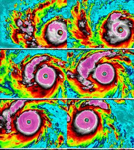
Eyewall replacement cycle is underway!
0 likes
The posts in this forum are NOT official forecast and should not be used as such. They are just the opinion of the poster and may or may not be backed by sound meteorological data. They are NOT endorsed by any professional institution or storm2k.org. For official information, please refer to RSMC, NHC and NWS products.
- 1900hurricane
- Category 5

- Posts: 6063
- Age: 34
- Joined: Fri Feb 06, 2015 12:04 pm
- Location: Houston, TX
- Contact:
Re: WPAC: NEPARTAK - Typhoon (Is a SuperTyphoon)
You could tell it was getting ready to happen when the eye temp started cooling back down again. I wonder how fast it can be completed.
It's also worth noting that Nepartak is now north of 20*N, which is a rule of thumb I like to use that says the more intense tropical cyclones start to weaken as they begin to feel some of the effects of the more hostile mid-latitudes. However, it's not infallible, especially in July when subtropical ridging is climatologically further north.
It's also worth noting that Nepartak is now north of 20*N, which is a rule of thumb I like to use that says the more intense tropical cyclones start to weaken as they begin to feel some of the effects of the more hostile mid-latitudes. However, it's not infallible, especially in July when subtropical ridging is climatologically further north.
0 likes
Contract Meteorologist. TAMU & MSST. Fiercely authentic, one of a kind. We are all given free will, so choose a life meant to be lived. We are the Masters of our own Stories.
Opinions expressed are mine alone.
Follow me on Twitter at @1900hurricane : Read blogs at https://1900hurricane.wordpress.com/
Opinions expressed are mine alone.
Follow me on Twitter at @1900hurricane : Read blogs at https://1900hurricane.wordpress.com/
- 1900hurricane
- Category 5

- Posts: 6063
- Age: 34
- Joined: Fri Feb 06, 2015 12:04 pm
- Location: Houston, TX
- Contact:
Re: WPAC: NEPARTAK - Typhoon (Is a SuperTyphoon)
If you look real closely, I think you can start to see the beginnings of eyewall replacement in the CDO when looking at the Ash RGB on JMA's Target Area.


0 likes
Contract Meteorologist. TAMU & MSST. Fiercely authentic, one of a kind. We are all given free will, so choose a life meant to be lived. We are the Masters of our own Stories.
Opinions expressed are mine alone.
Follow me on Twitter at @1900hurricane : Read blogs at https://1900hurricane.wordpress.com/
Opinions expressed are mine alone.
Follow me on Twitter at @1900hurricane : Read blogs at https://1900hurricane.wordpress.com/
- 1900hurricane
- Category 5

- Posts: 6063
- Age: 34
- Joined: Fri Feb 06, 2015 12:04 pm
- Location: Houston, TX
- Contact:
Re: WPAC: NEPARTAK - Typhoon (Is a SuperTyphoon)
Yep, that's it, you can start to see in on the color IR now too.

0 likes
Contract Meteorologist. TAMU & MSST. Fiercely authentic, one of a kind. We are all given free will, so choose a life meant to be lived. We are the Masters of our own Stories.
Opinions expressed are mine alone.
Follow me on Twitter at @1900hurricane : Read blogs at https://1900hurricane.wordpress.com/
Opinions expressed are mine alone.
Follow me on Twitter at @1900hurricane : Read blogs at https://1900hurricane.wordpress.com/
- mrbagyo
- Category 5

- Posts: 3963
- Age: 33
- Joined: Thu Apr 12, 2012 9:18 am
- Location: 14.13N 120.98E
- Contact:
Re: WPAC: NEPARTAK - Typhoon (Is a SuperTyphoon)
Remains at 150 knots.
02W NEPARTAK 160706 1200 20.2N 126.9E WPAC 150 911
The CDO has expanded significantly today which imo would give it a better chance of surviving the cycle.
I also expect the cycle to be a fast one akin to Soudelor (2015)- a textbook eyewall replacement cycle not the "ew loooking" cinnamon roll type of ERC
Last edited by mrbagyo on Wed Jul 06, 2016 10:44 am, edited 1 time in total.
0 likes
The posts in this forum are NOT official forecast and should not be used as such. They are just the opinion of the poster and may or may not be backed by sound meteorological data. They are NOT endorsed by any professional institution or storm2k.org. For official information, please refer to RSMC, NHC and NWS products.
- Yellow Evan
- Professional-Met

- Posts: 16231
- Age: 27
- Joined: Fri Jul 15, 2011 12:48 pm
- Location: Henderson, Nevada/Honolulu, HI
- Contact:
- mrbagyo
- Category 5

- Posts: 3963
- Age: 33
- Joined: Thu Apr 12, 2012 9:18 am
- Location: 14.13N 120.98E
- Contact:
Re: WPAC: NEPARTAK - Typhoon (Is a SuperTyphoon)
The last typhoon to make landfall over Central Taiwan or even in the entirety of Taiwan as a Category 5 storm was Typhoon Bilis in year 2000 - it struck central Taiwan as a 260 kph juggernaut.
Here are the other category 5 storms that were able to make landfall in Taiwan at cat 5 strength:
Winnie (1958)
Joan (1959)
Opal (1962)
Here are the other category 5 storms that were able to make landfall in Taiwan at cat 5 strength:
Winnie (1958)
Joan (1959)
Opal (1962)
Last edited by mrbagyo on Wed Jul 06, 2016 11:35 am, edited 1 time in total.
0 likes
The posts in this forum are NOT official forecast and should not be used as such. They are just the opinion of the poster and may or may not be backed by sound meteorological data. They are NOT endorsed by any professional institution or storm2k.org. For official information, please refer to RSMC, NHC and NWS products.
-
CrazyC83
- Professional-Met

- Posts: 34315
- Joined: Tue Mar 07, 2006 11:57 pm
- Location: Deep South, for the first time!
Re: WPAC: NEPARTAK - Typhoon (Is a SuperTyphoon)
I'm guessing it probably peaked at 0600Z at 165 kt, but has come down some since. The ERC could result in a larger RMW which could mean much more damage in Taiwan...
0 likes
- StormChaser75
- Tropical Storm

- Posts: 101
- Age: 24
- Joined: Sat Feb 06, 2016 4:23 pm
- Location: Corpus Christi TX
- Contact:
Re: WPAC: NEPARTAK - Typhoon (Is a SuperTyphoon)
Alan I was just about to post that image ! XD you beat me to it, a rgb sat image from the central weather bureau

Nice pin hole eye on it to and most likely expected to expand more if it continues the EWRC.


Nice pin hole eye on it to and most likely expected to expand more if it continues the EWRC.


Last edited by StormChaser75 on Wed Jul 06, 2016 1:24 pm, edited 1 time in total.
0 likes
- cycloneye
- Admin

- Posts: 149275
- Age: 69
- Joined: Thu Oct 10, 2002 10:54 am
- Location: San Juan, Puerto Rico
Re: WPAC: NEPARTAK - Typhoon (Is a SuperTyphoon)
0 likes
Visit the Caribbean-Central America Weather Thread where you can find at first post web cams,radars
and observations from Caribbean basin members Click Here
and observations from Caribbean basin members Click Here
- cycloneye
- Admin

- Posts: 149275
- Age: 69
- Joined: Thu Oct 10, 2002 10:54 am
- Location: San Juan, Puerto Rico
Re: WPAC: NEPARTAK - Typhoon (Is a SuperTyphoon)
alan1961 wrote:http://i.imgur.com/g4BYpDG.jpg
Coming into view on Taiwan radar
Do you have the link to radar?
0 likes
Visit the Caribbean-Central America Weather Thread where you can find at first post web cams,radars
and observations from Caribbean basin members Click Here
and observations from Caribbean basin members Click Here
- cycloneye
- Admin

- Posts: 149275
- Age: 69
- Joined: Thu Oct 10, 2002 10:54 am
- Location: San Juan, Puerto Rico
Re: WPAC: NEPARTAK - Typhoon (Is a SuperTyphoon)
0 likes
Visit the Caribbean-Central America Weather Thread where you can find at first post web cams,radars
and observations from Caribbean basin members Click Here
and observations from Caribbean basin members Click Here
- cycloneye
- Admin

- Posts: 149275
- Age: 69
- Joined: Thu Oct 10, 2002 10:54 am
- Location: San Juan, Puerto Rico
Re: WPAC: NEPARTAK - Typhoon (Is a SuperTyphoon)
0 likes
Visit the Caribbean-Central America Weather Thread where you can find at first post web cams,radars
and observations from Caribbean basin members Click Here
and observations from Caribbean basin members Click Here
- 1900hurricane
- Category 5

- Posts: 6063
- Age: 34
- Joined: Fri Feb 06, 2015 12:04 pm
- Location: Houston, TX
- Contact:
Re: WPAC: NEPARTAK - Typhoon (Is a SuperTyphoon)
Eyewall replacement is already in its final stages.


0 likes
Contract Meteorologist. TAMU & MSST. Fiercely authentic, one of a kind. We are all given free will, so choose a life meant to be lived. We are the Masters of our own Stories.
Opinions expressed are mine alone.
Follow me on Twitter at @1900hurricane : Read blogs at https://1900hurricane.wordpress.com/
Opinions expressed are mine alone.
Follow me on Twitter at @1900hurricane : Read blogs at https://1900hurricane.wordpress.com/
- 1900hurricane
- Category 5

- Posts: 6063
- Age: 34
- Joined: Fri Feb 06, 2015 12:04 pm
- Location: Houston, TX
- Contact:
Re: WPAC: NEPARTAK - Typhoon (Is a SuperTyphoon)
Not relevant right now, but here is a MODIS Aqua pass from yesterday/earlier today (depending on your timezone).


0 likes
Contract Meteorologist. TAMU & MSST. Fiercely authentic, one of a kind. We are all given free will, so choose a life meant to be lived. We are the Masters of our own Stories.
Opinions expressed are mine alone.
Follow me on Twitter at @1900hurricane : Read blogs at https://1900hurricane.wordpress.com/
Opinions expressed are mine alone.
Follow me on Twitter at @1900hurricane : Read blogs at https://1900hurricane.wordpress.com/
Who is online
Users browsing this forum: No registered users and 40 guests


