ATL: BONNIE - Post-Tropical - Discussion

Moderator: S2k Moderators

Message
Author
tolakram
Admin
Admin
Posts: 20009
Age: 62
Joined: Sun Aug 27, 2006 8:23 pm
Location: Florence, KY (name is Mark)

Re: ATL: TWO - Tropical Depression - Discussion

#361 Postby tolakram » Sat May 28, 2016 8:52 am

It's moving through an airmass that gave us very cool weather last week, I wonder if that has something to do with it?

Saved radar gifs

Image

Image
0 likes   
M a r k
- - - - -
Join us in chat: Storm2K Chatroom Invite. Android and IOS apps also available.

The posts in this forum are NOT official forecasts and should not be used as such. Posts are NOT endorsed by any professional institution or STORM2K.org. For official information and forecasts, please refer to NHC and NWS products.

User avatar
tarheelprogrammer
S2K Supporter
S2K Supporter
Posts: 1793
Joined: Mon Mar 28, 2016 9:25 pm
Location: Raleigh, NC area (Garner, NC)

Re: ATL: TWO - Tropical Depression - Discussion

#362 Postby tarheelprogrammer » Sat May 28, 2016 9:05 am

If only the center could tuck under the convection and stay there. Levin Cowan posted on twitter that shear is a little higher in the area than satellites are showing it to be.

Edit: Got a warning for this so let me clarify my statement. I do not wish this to strengthen and I have seen first hand what these storms can do. I meant this statement only in regards for the storm's chances. Being a loving family man I only follow these storms because they fascinate me not because I want them to strengthen and hurt people.
Last edited by tarheelprogrammer on Sat May 28, 2016 11:26 am, edited 1 time in total.
0 likes   
My posts are not official forecasts. They are just my opinion and may or may not be backed by sound meteorological data. They are NOT endorsed by any professional institution or storm2k.org. For official information, please refer to the NHC and NWS products.

User avatar
cycloneye
Admin
Admin
Posts: 145296
Age: 68
Joined: Thu Oct 10, 2002 10:54 am
Location: San Juan, Puerto Rico

Re: ATL: TWO - Tropical Depression - Discussion

#363 Postby cycloneye » Sat May 28, 2016 9:42 am

SUMMARY OF 1100 AM EDT...1500 UTC...INFORMATION
-----------------------------------------------
LOCATION...30.3N 78.5W
ABOUT 195 MI...310 KM SSE OF CHARLESTON SOUTH CAROLINA
ABOUT 250 MI...405 KM S OF CAPE FEAR NORTH CAROLINA
MAXIMUM SUSTAINED WINDS...35 MPH...55 KM/H
PRESENT MOVEMENT...NW OR 310 DEGREES AT 13 MPH...20 KM/H
MINIMUM CENTRAL PRESSURE...1009 MB...29.80 INCHES
0 likes   
Visit the Caribbean-Central America Weather Thread where you can find at first post web cams,radars
and observations from Caribbean basin members Click Here

User avatar
cycloneye
Admin
Admin
Posts: 145296
Age: 68
Joined: Thu Oct 10, 2002 10:54 am
Location: San Juan, Puerto Rico

Re: ATL: TWO - Advisories

#364 Postby cycloneye » Sat May 28, 2016 9:52 am

BULLETIN
TROPICAL DEPRESSION TWO ADVISORY NUMBER 4
NWS NATIONAL HURRICANE CENTER MIAMI FL AL022016
1100 AM EDT SAT MAY 28 2016

...DEPRESSION FORECAST TO BECOME A TROPICAL STORM LATER TODAY...
...OUTER RAINBANDS APPROACHING THE SOUTH CAROLINA COAST...


SUMMARY OF 1100 AM EDT...1500 UTC...INFORMATION
-----------------------------------------------
LOCATION...30.3N 78.5W
ABOUT 195 MI...310 KM SSE OF CHARLESTON SOUTH CAROLINA
ABOUT 250 MI...405 KM S OF CAPE FEAR NORTH CAROLINA
MAXIMUM SUSTAINED WINDS...35 MPH...55 KM/H
PRESENT MOVEMENT...NW OR 310 DEGREES AT 13 MPH...20 KM/H
MINIMUM CENTRAL PRESSURE...1009 MB...29.80 INCHES


WATCHES AND WARNINGS
--------------------
CHANGES WITH THIS ADVISORY:

None.

SUMMARY OF WATCHES AND WARNINGS IN EFFECT:

A Tropical Storm Warning is in effect for...
* Savannah River to Little River Inlet South Carolina

A Tropical Storm Warning means that tropical storm conditions are
expected somewhere within the warning area, in this case within
24 hours.

For storm information specific to your area, including possible
inland watches and warnings, please monitor products issued by your
local National Weather Service forecast office.


DISCUSSION AND 48-HOUR OUTLOOK
------------------------------
At 1100 AM EDT (1500 UTC), the center of Tropical Depression Two was
estimated by an Air Force Reserve reconnaissance aircraft to be near
latitude 30.3 North, longitude 78.5 West. The depression is moving
toward the northwest near 13 mph (20 km/h). This general motion,
accompanied by a decrease in forward speed, is expected later today
and on Sunday as the system nears the coast within the warning area.

Maximum sustained winds are near 35 mph (55 km/h) with higher gusts.
Recent data from the reconnaissance aircraft indicate that the
tropical cyclone remains just below tropical storm strength.
However, the depression is forecast to become a tropical storm later
today as it moves over the warm waters of the Gulf Stream.

The estimated minimum central pressure is 1009 mb (29.80 inches).


HAZARDS AFFECTING LAND
----------------------
WIND: Tropical storm conditions are expected to first reach the
coast within the warning area later tonight or early Sunday.

RAINFALL: The depression is expected to produce total rainfall
accumulations of 1 to 3 inches from eastern South Carolina through
southeastern North Carolina.

STORM SURGE: Storm surge inundation of 1 to 2 feet above ground
level is possible within the tropical storm warning area.

SURF: This system is expected to produce life-threatening surf and
rip current conditions along portions of the southeastern United
States coast through the weekend. Please consult products from your
local weather office.


NEXT ADVISORY
-------------
Next intermediate advisory at 200 PM EDT.
Next complete advisory at 500 PM EDT.

$$
Forecaster Stewart


TROPICAL DEPRESSION TWO DISCUSSION NUMBER 4
NWS NATIONAL HURRICANE CENTER MIAMI FL AL022016
1100 AM EDT SAT MAY 28 2016

Satellite and NOAA WSR-88D radar data indicate that deep convection
has increased in the northern semicircle of the depression's
circulation since the previous advisory. However, the depression
remains a sheared tropical cyclone due to southeasterly upper-level
winds of 20-25 kt. An Air Force Reserve reconnaissance aircraft
investigated the cyclone this morning and obtained reliable SFMR
surface winds of at least 30 kt. Satellite intensity estimates
were also T2.0/30 kt from both TAFB and SAB, so the intensity is
being maintained at 30 kt for this advisory.

Microwave satellite and recon fix positions indicate that the
cyclone has made a jog toward the west-northwest during the past six
hours. However, smoothing through these short-term wobbles yields a
12-hour motion of 310/11 kt. The ECMWF and GFS models actually did
quite well in predicting this recent short-term wobble, and both
models turn the depression more toward the right, accompanied by
a steady decrease in forward speed over the next 24 hours as the
cyclone nears the South Carolina coast. As a result, the new NHC
forecast track lies slightly to the left of the previous advisory
track through 12 hours, primarily to account for the more westward
initial position, and then is near the previous track and a blend
of the GFS-ECMWF model consensus track at 24 hours and beyond.

The depression is beginning to move over the eastern wall of the
Gulf Stream where sea-surface temperatures are 27-28 deg C. Outer
convective bands have also developed over the slightly cooler shelf
waters between the South Carolina coast and the Gulf Stream, which
implies that there might not be as much of a weakening effect by
those cooler waters as previously anticipated. However, southerly
vertical wind shear is forecast by the SHIPS model to increase to
more than 20 kt before the cyclone reaches the coast, and that is
expected to inhibit any significant strengthening. It is possible
that the cyclone could peak at around 40 kt while it is over the
Gulf Stream this afternoon and evening, followed by slight weakening
just before it reaches the coast. The official intensity forecast is
similar to the previous advisory and closely follows the Decay-SHIPS
intensity model.

FORECAST POSITIONS AND MAX WINDS

INIT 28/1500Z 30.3N 78.5W 30 KT 35 MPH
12H 29/0000Z 31.3N 79.5W 35 KT 40 MPH
24H 29/1200Z 32.4N 80.3W 35 KT 40 MPH
36H 30/0000Z 32.7N 80.3W 30 KT 35 MPH...INLAND
48H 30/1200Z 33.0N 79.7W 30 KT 35 MPH...INLAND
72H 31/1200Z 33.6N 78.0W 30 KT 35 MPH...POST-TROP/REMNT LOW
96H 01/1200Z 34.4N 76.8W 25 KT 30 MPH...POST-TROP/REMNT LOW
120H 02/1200Z 34.9N 75.8W 25 KT 30 MPH...POST-TROP/REMNT LOW

$$
Forecaster Stewart
0 likes   
Visit the Caribbean-Central America Weather Thread where you can find at first post web cams,radars
and observations from Caribbean basin members Click Here

User avatar
cycloneye
Admin
Admin
Posts: 145296
Age: 68
Joined: Thu Oct 10, 2002 10:54 am
Location: San Juan, Puerto Rico

Re: ATL: TWO - Recon

#365 Postby cycloneye » Sat May 28, 2016 9:57 am

The next mission departs this afternoon at 4:45 PM EDT. I can't be here to post the data so who wants to do it?

FIGHT ONE - TEAL 73
A. 28/2330Z
B. AFXXX 0301A CYCLONE
C. 28/2045Z
D. 29.9N 76.8W
E. 28/2300Z TO 29/0330Z
F. SFC TO 10,000 FT
0 likes   
Visit the Caribbean-Central America Weather Thread where you can find at first post web cams,radars
and observations from Caribbean basin members Click Here

User avatar
Yellow Evan
Professional-Met
Professional-Met
Posts: 16143
Age: 27
Joined: Fri Jul 15, 2011 12:48 pm
Location: Henderson, Nevada/Honolulu, HI
Contact:

Re: ATL: TWO - Tropical Depression - Discussion

#366 Postby Yellow Evan » Sat May 28, 2016 10:55 am

Looks like mid-level shear is killing this.
0 likes   

User avatar
cycloneye
Admin
Admin
Posts: 145296
Age: 68
Joined: Thu Oct 10, 2002 10:54 am
Location: San Juan, Puerto Rico

Re: ATL: TWO - Tropical Depression - Discussion

#367 Postby cycloneye » Sat May 28, 2016 11:03 am

Nitid look of TD Two from the ISS.

Image
0 likes   
Visit the Caribbean-Central America Weather Thread where you can find at first post web cams,radars
and observations from Caribbean basin members Click Here

User avatar
wxman57
Moderator-Pro Met
Moderator-Pro Met
Posts: 22978
Age: 67
Joined: Sat Jun 21, 2003 8:06 pm
Location: Houston, TX (southwest)

Re: ATL: TWO - Tropical Depression - Discussion

#368 Postby wxman57 » Sat May 28, 2016 11:23 am

The center appears to be well-removed from the convection to the northwest, and it's not very organized. May not make it to Bonnie before landfall tomorrow morning. Just a good bit of rain for the Carolinas this weekend.
0 likes   

User avatar
cycloneye
Admin
Admin
Posts: 145296
Age: 68
Joined: Thu Oct 10, 2002 10:54 am
Location: San Juan, Puerto Rico

Re: ATL: TWO - Advisories

#369 Postby cycloneye » Sat May 28, 2016 1:03 pm

BULLETIN
TROPICAL DEPRESSION TWO INTERMEDIATE ADVISORY NUMBER 4A
NWS NATIONAL HURRICANE CENTER MIAMI FL AL022016
200 PM EDT SAT MAY 28 2016

...DEPRESSION FORECAST TO BECOME A TROPICAL STORM LATER TODAY...
...OUTER RAINBANDS MOVING ONSHORE THE SOUTH CAROLINA COAST...


SUMMARY OF 200 PM EDT...1800 UTC...INFORMATION
----------------------------------------------
LOCATION...30.7N 79.0W
ABOUT 150 MI...240 KM SSE OF CHARLESTON SOUTH CAROLINA
ABOUT 225 MI...360 KM SSW OF CAPE FEAR NORTH CAROLINA
MAXIMUM SUSTAINED WINDS...35 MPH...55 KM/H
PRESENT MOVEMENT...NW OR 310 DEGREES AT 13 MPH...20 KM/H
MINIMUM CENTRAL PRESSURE...1009 MB...29.80 INCHES


WATCHES AND WARNINGS
--------------------
CHANGES WITH THIS ADVISORY:

None.

SUMMARY OF WATCHES AND WARNINGS IN EFFECT:

A Tropical Storm Warning is in effect for...
* Savannah River to Little River Inlet South Carolina

A Tropical Storm Warning means that tropical storm conditions are
expected somewhere within the warning area, in this case within
24 hours.

For storm information specific to your area, including possible
inland watches and warnings, please monitor products issued by your
local National Weather Service forecast office.


DISCUSSION AND 48-HOUR OUTLOOK
------------------------------
At 200 PM EDT (1800 UTC), the center of Tropical Depression Two was
estimated to be near latitude 30.7 North, longitude 79.0 West. The
depression is moving toward the northwest near 13 mph (20 km/h).
This general motion, accompanied by a decrease in forward speed, is
expected later today and on Sunday as the system nears the coast
within the warning area.

Maximum sustained winds are near 35 mph (55 km/h) with higher gusts.
The depression is forecast to become a tropical storm later today as
it continues to move over the warm waters of the Gulf Stream.

The estimated minimum central pressure is 1009 mb (29.80 inches).


HAZARDS AFFECTING LAND
----------------------
WIND: Tropical storm conditions are expected to first reach the
coast within the warning area later tonight or early Sunday.

RAINFALL: The depression is expected to produce total rainfall
accumulations of 1 to 3 inches from eastern South Carolina through
southeastern North Carolina.

STORM SURGE: Storm surge inundation of 1 to 2 feet above ground
level is possible within the tropical storm warning area.

SURF: This system is expected to produce life-threatening surf and
rip current conditions along portions of the southeastern United
States coast through the weekend. Please consult products from your
local weather office.


NEXT ADVISORY
-------------
Next complete advisory at 500 PM EDT.

$$
Forecaster Stewart
0 likes   
Visit the Caribbean-Central America Weather Thread where you can find at first post web cams,radars
and observations from Caribbean basin members Click Here

TheStormExpert

Re: ATL: TWO - Tropical Depression - Discussion

#370 Postby TheStormExpert » Sat May 28, 2016 1:26 pm

I highly doubt now this gets named a TS. :roll:
0 likes   

User avatar
SouthDadeFish
Professional-Met
Professional-Met
Posts: 2835
Joined: Thu Sep 23, 2010 2:54 pm
Location: Miami, FL
Contact:

Re: ATL: TWO - Tropical Depression - Discussion

#371 Postby SouthDadeFish » Sat May 28, 2016 1:35 pm

I wouldn't be surprised to see a center reformation closer toward the edge of the persistent deep convection. If this happens, a band of strong convection could develop immediately downshear of the TC center, which could easily have TS winds. This could happen by the time recon gets there this afternoon/evening. In terms of actual impacts to land, it likely wouldn't change anything, but something to keep an eye on.
0 likes   

User avatar
Hammy
Category 5
Category 5
Posts: 5849
Age: 41
Joined: Fri May 25, 2012 5:25 pm
Contact:

Re: ATL: TWO - Tropical Depression - Discussion

#372 Postby Hammy » Sat May 28, 2016 3:02 pm

SouthDadeFish wrote:I wouldn't be surprised to see a center reformation closer toward the edge of the persistent deep convection. If this happens, a band of strong convection could develop immediately downshear of the TC center, which could easily have TS winds. This could happen by the time recon gets there this afternoon/evening. In terms of actual impacts to land, it likely wouldn't change anything, but something to keep an eye on.


That seems to have happened in the last hour, with a smaller and tighter vortex close to a large convective buildup and the old center getting sucked into it. The models show some amount of brief intensification in the next 4-6 hours as well, is that about when the plane arrives?
0 likes   
The above post is not official and should not be used as such. It is the opinion of the poster and may or may not be backed by sound meteorological data. It is not endorsed by any professional institution or storm2k.org. For official information, please refer to the NHC and NWS products.

SeGaBob

Re: ATL: TWO - Tropical Depression - Discussion

#373 Postby SeGaBob » Sat May 28, 2016 3:03 pm

These clouds are depressing. :wink:
It's aggravating to watch all that rain we won't get though. :(
0 likes   

User avatar
AJC3
Admin
Admin
Posts: 3999
Age: 61
Joined: Tue Aug 31, 2004 7:04 pm
Location: Ballston Spa, New York
Contact:

Re: ATL: TWO - Tropical Depression - Discussion

#374 Postby AJC3 » Sat May 28, 2016 3:18 pm

Hammy wrote:
SouthDadeFish wrote:I wouldn't be surprised to see a center reformation closer toward the edge of the persistent deep convection. If this happens, a band of strong convection could develop immediately downshear of the TC center, which could easily have TS winds. This could happen by the time recon gets there this afternoon/evening. In terms of actual impacts to land, it likely wouldn't change anything, but something to keep an eye on.


That seems to have happened in the last hour, with a smaller and tighter vortex close to a large convective buildup and the old center getting sucked into it. The models show some amount of brief intensification in the next 4-6 hours as well, is that about when the plane arrives?


I was just about to post this observation. You can see the center did a classic jump or reformation downshear toward the stronger convection, though it still remains exposed on the SE edge. I suspect It's likely to continue this trend into this evening.

Image

Image
0 likes   

User avatar
Hammy
Category 5
Category 5
Posts: 5849
Age: 41
Joined: Fri May 25, 2012 5:25 pm
Contact:

Re: ATL: TWO - Tropical Depression - Discussion

#375 Postby Hammy » Sat May 28, 2016 3:33 pm

We have Bonnie. Not surprising given the center reformation and that it looks like it's spun up a bit faster since then.
0 likes   
The above post is not official and should not be used as such. It is the opinion of the poster and may or may not be backed by sound meteorological data. It is not endorsed by any professional institution or storm2k.org. For official information, please refer to the NHC and NWS products.

TheStormExpert

Re: ATL: TWO - Tropical Depression - Discussion

#376 Postby TheStormExpert » Sat May 28, 2016 3:33 pm

We have TS Bonnie y'all! :D
0 likes   

User avatar
cycloneye
Admin
Admin
Posts: 145296
Age: 68
Joined: Thu Oct 10, 2002 10:54 am
Location: San Juan, Puerto Rico

Re: ATL: BONNIE - Advisories

#377 Postby cycloneye » Sat May 28, 2016 3:43 pm

BULLETIN
TROPICAL STORM BONNIE ADVISORY NUMBER 5
NWS NATIONAL HURRICANE CENTER MIAMI FL AL022016
500 PM EDT SAT MAY 28 2016

...DEPRESSION STRENGTHENS INTO TROPICAL STORM BONNIE...
...LOCALLY HEAVY RAINFALL SPREADING ACROSS COASTAL AREAS OF SOUTH
CAROLINA...


SUMMARY OF 500 PM EDT...2100 UTC...INFORMATION
----------------------------------------------
LOCATION...31.1N 79.4W
ABOUT 120 MI...190 KM SE OF BEAUFORT SOUTH CAROLINA
ABOUT 125 MI...195 KM SSE OF CHARLESTON SOUTH CAROLINA
MAXIMUM SUSTAINED WINDS...40 MPH...65 KM/H
PRESENT MOVEMENT...NW OR 320 DEGREES AT 10 MPH...17 KM/H
MINIMUM CENTRAL PRESSURE...1008 MB...29.77 INCHES


WATCHES AND WARNINGS
--------------------
CHANGES WITH THIS ADVISORY:

None.

SUMMARY OF WATCHES AND WARNINGS IN EFFECT:

A Tropical Storm Warning is in effect for...
* Savannah River to Little River Inlet South Carolina

A Tropical Storm Warning means that tropical storm conditions are
expected somewhere within the warning area, in this case within the
next 12 hours.

For storm information specific to your area, including possible
inland watches and warnings, please monitor products issued by your
local National Weather Service forecast office.


DISCUSSION AND 48-HOUR OUTLOOK
------------------------------
At 500 PM EDT (2100 UTC), the center of Tropical Storm Bonnie was
located by satellite and NOAA Doppler radars near latitude 31.1
North, longitude 79.4 West. Bonnie is moving toward the northwest
near 10 mph (17 km/h). This general motion, accompanied by a
decrease in forward speed, is expected through this evening and on
Sunday as the system nears the coast within the warning area.

Maximum sustained winds have increased to near 40 mph (65 km/h) with
higher gusts. Some additional strengthening is possible tonight as
Bonnie moves over the warm waters of the Gulf Stream. Gradual
weakening is forecast on Sunday.

Tropical-storm-force winds extend outward up to 60 miles (95 km)
from the center, mainly to the northwest of the center.

The estimated minimum central pressure is 1008 mb (29.77 inches).


HAZARDS AFFECTING LAND
----------------------
WIND: Tropical storm conditions are expected to first reach the
coast within the warning area later tonight or early Sunday.

RAINFALL: Bonnie is expected to produce total rainfall accumulations
of 1 to 3 inches with maximum totals of 5 inches from eastern
South Carolina through southeastern North Carolina.

STORM SURGE: Storm surge inundation of 1 to 2 feet above ground
level is possible within the tropical storm warning area during the
next high tide on Sunday morning.

SURF: Bonnie is expected to produce life-threatening surf and
rip current conditions along portions of the southeastern United
States coast through the weekend. Please consult products from your
local weather office.

TORNADOES: An isolated tornado or two will be possible late tonight
and early Sunday over the immediate coastal region from central
South Carolina through southern North Carolina.


NEXT ADVISORY
-------------
Next intermediate advisory at 800 PM EDT.
Next complete advisory at 1100 PM EDT.

$$
Forecaster Stewart


TROPICAL STORM BONNIE DISCUSSION NUMBER 5
NWS NATIONAL HURRICANE CENTER MIAMI FL AL022016
500 PM EDT SAT MAY 28 2016

A 1431Z ASCAT-B overpass indicated two 34-kt wind vectors existed in
the northwest quadrant of the tropical cyclone in a region of deep
convection that was not sampled during the earlier reconnaissance
mission. Convection briefly weakened, but has redeveloped and
persisted in that same part of the storm circulation for the past 5
hours. Furthermore, NOAA Doppler velocity radar data from Charleston
and Jacksonville have indicated winds ranging from 50-55 kt between
15,000 and 20,000 feet in the same area of the 34-kt ASCAT wind
vectors. Based on these data, the depression has been upgraded
to Tropical Storm Bonnie.

The initial motion estimate is 320/09 kt. The exposed low-level
center near the southeastern edge of the deep convective cloud
canopy has been easy to track over the past several hours, and has
essentially been moving along the previous forecast track. The NHC
model guidance remains in good agreement on Bonnie gradually turning
toward the north-northwest as it moves around the west side of a
deep-layer ridge, and moving onshore between Charleston and
Beaufort, South Carolina, in about 18-24 hours. After landfall a
mid-level shortwave trough moving northeastward out of the
Mississippi Valley region is expected to significantly weaken the
ridge, causing the steering to collapse. The result is that Bonnie
is forecast to stall or meander along the coastal region of South
Carolina in 24-36 hours before drifting off to the east or northeast
by 48 hours. The NHC forecast track is similar to the previous
advisory track, and closely follows a blend of GFS and ECMWF models.

Bonnie is currently moving over the axis of warmest Gulf Stream
sea-surface temperatures of 27-28 deg C. Although slightly cooler
shelf water lies ahead of the cyclone, those ocean conditions do
not appear to be sufficient to significantly weaken Bonnie based on
rather vigorous convection that has developed just offshore of
South Carolina today. However, southerly vertical wind shear of at
least 20 kt is expected to prevent any rapid or significant
intensification before landfall. After 24 hours, land interaction
and the aforementioned wind shear should induce slow weakening,
although there could be some convective rain bands over water
producing wind gusts to tropical-storm force until about 48 hours.
The official intensity forecast is similar to the previous advisory
and follows the Decay-SHIPS model.

The primary impact from Bonnie is expected to be locally heavy
rainfall.

FORECAST POSITIONS AND MAX WINDS

INIT 28/2100Z 31.1N 79.4W 35 KT 40 MPH
12H 29/0600Z 31.9N 80.1W 40 KT 45 MPH
24H 29/1800Z 32.8N 80.5W 35 KT 40 MPH...INLAND
36H 30/0600Z 33.2N 80.1W 30 KT 35 MPH...INLAND
48H 30/1800Z 33.5N 79.4W 30 KT 35 MPH...INLAND
72H 31/1800Z 34.5N 77.8W 25 KT 30 MPH...INLAND
96H 01/1800Z 35.0N 76.5W 25 KT 30 MPH...POST-TROP/REMNT LOW
120H 02/1800Z 35.7N 75.3W 25 KT 30 MPH...POST-TROP/REMNT LOW

$$
Forecaster Stewart
0 likes   
Visit the Caribbean-Central America Weather Thread where you can find at first post web cams,radars
and observations from Caribbean basin members Click Here

User avatar
SouthDadeFish
Professional-Met
Professional-Met
Posts: 2835
Joined: Thu Sep 23, 2010 2:54 pm
Location: Miami, FL
Contact:

Re: ATL: BONNIE - Tropical Storm - Discussion

#378 Postby SouthDadeFish » Sat May 28, 2016 3:53 pm

With the velocities showing up on radar, I wouldn't be surprised if recon finds Bonnie to be a bit stronger than 35 kt... That's some vigorous convection.
0 likes   

ozonepete
Professional-Met
Professional-Met
Posts: 4743
Joined: Mon Sep 07, 2009 3:23 pm
Location: From Ozone Park, NYC / Now in Brooklyn, NY

Re: ATL: BONNIE - Tropical Storm - Discussion

#379 Postby ozonepete » Sat May 28, 2016 3:53 pm

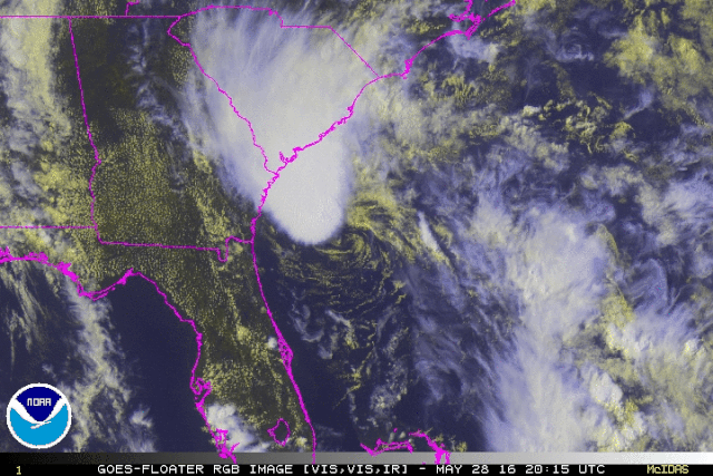
AJC3 you had it right. :) Here's an rgb image which shows the recent, considerable blow-up of convection with the LLC rushing in under it. They should couple fairly well if the shear drops. Of course shear forecasts are still the weakest part of the strength forecast package. They still very often stink.

Image
0 likes   

psyclone
S2K Supporter
S2K Supporter
Posts: 4762
Joined: Wed Aug 24, 2005 9:04 pm
Location: palm harbor fl

Re: ATL: BONNIE - Tropical Storm - Discussion

#380 Postby psyclone » Sat May 28, 2016 4:00 pm

Typical anticlimactic start to the season...like the first flurries for snow nuts up north...but it's trying. looks like a good dousing for portions of the low country.
0 likes   


Return to “2016”

Who is online

Users browsing this forum: No registered users and 5 guests