ATL: HERMINE - Post-Tropical - Discussion

Moderator: S2k Moderators

Message
Author
User avatar
La Sirena
Category 1
Category 1
Posts: 307
Joined: Sun Aug 21, 2016 4:02 pm
Location: Formerly of the Keys, back home in East TN

Re: ATL: INVEST 99L - Discussion

#3621 Postby La Sirena » Sun Aug 28, 2016 6:17 am

Alyono wrote:
La Sirena wrote:
Alyono wrote:development chances are increasing rapidly. May be close to 90% now

Development....today? Or is this once it hits the GOM?


overall development chances

Excellent! Thanks for the clarification. Wasn't sure if I just missed something.
0 likes   
The posts in this forum are NOT official forecasts and should not be used as such. They are just the opinion of the poster and may or may not be backed by sound meteorological data. They are NOT endorsed by any professional institution or STORM2K. For official information, please refer to products from the NHC and NWS.


Hurricane Irma,Hurricane Michael, Hurricane Helene

User avatar
chris_fit
Category 5
Category 5
Posts: 3249
Age: 42
Joined: Wed Sep 10, 2003 11:58 pm
Location: Tampa Bay Area, FL

Re: ATL: INVEST 99L - Discussion

#3622 Postby chris_fit » Sun Aug 28, 2016 6:23 am

GM All!

Is this an LLC we see this morning? Just WSW of Andros

http://radar.weather.gov/radar.php?rid= ... 1&loop=yes
0 likes   

Rail Dawg
S2K Supporter
S2K Supporter
Posts: 326
Joined: Mon Aug 27, 2012 5:02 pm
Location: Where the eye makes landfall.

Re: ATL: INVEST 99L - Discussion

#3623 Postby Rail Dawg » Sun Aug 28, 2016 6:25 am

Will be flying (pilot) along western edge of system in about 6 hours on the way from NYC to Cancun. We have the ability to ask the air traffic folks to let us scoot in a little closer while of course keeping everything safe

I like watching the winds shift and speed change at the Flight Levels as we head south. Today's GPS's are quite accurate and our on-board weather radar gives us a unique sideways look at the action.

Sat pics and models are great but nothing beats what many of us spent years doing and that is observing the weather the old-fashioned way!

I agree when this storm gets named it should be named 99L lol.
3 likes   
Although I have been a hurricane forecaster since 1980 that only means I've been wrong lots of times.

jlauderdal
S2K Supporter
S2K Supporter
Posts: 7202
Joined: Wed May 19, 2004 5:46 am
Location: NE Fort Lauderdale
Contact:

Re: ATL: INVEST 99L - Discussion

#3624 Postby jlauderdal » Sun Aug 28, 2016 6:27 am

chris_fit wrote:GM All!

Is this an LLC we see this morning? Just WSW of Andros

http://radar.weather.gov/radar.php?rid= ... 1&loop=yes


mlc...remember long range is looking up the farther away you go...there is definite turning but to be clear nothing imminent as far as LLC..wet and breezy for SE florida next 3-5 days, the influence of this system will be with us all week, how much actual rain it can produce is in question...panhandle big bend potential much larger problems

EricBlake128 mins
#99L coming into Key West radar range in the #Florida Straits this morning- broad rotation noted https://t.co/a5yMl8H0QH
1 likes   

SunnyThoughts
Category 5
Category 5
Posts: 2263
Joined: Wed Jul 09, 2003 12:42 pm
Location: Pensacola, Florida

Re: ATL: INVEST 99L - Discussion

#3625 Postby SunnyThoughts » Sun Aug 28, 2016 6:29 am

Rail Dawg wrote:Will be flying (pilot) along western edge of system in about 6 hours on the way from NYC to Cancun. We have the ability to ask the air traffic folks to let us scoot in a little closer while of course keeping everything safe

I like watching the winds shift and speed change at the Flight Levels as we head south. Today's GPS's are quite accurate and our on-board weather radar gives us a unique sideways look at the action.

Sat pics and models are great but nothing beats what many of us spent years doing and that is observing the weather the old-fashioned way!

I agree when this storm gets named it should be named 99L lol.


Good luck and be careful Rail Dawg. Speaking of "flights" I'm betting the Hurricane Hunters go as planned this afternoon as opposed to being cancelled as they have been the last day or two.
0 likes   

User avatar
Nimbus
Category 5
Category 5
Posts: 5342
Joined: Mon Jul 19, 2004 10:54 am

Re: ATL: INVEST 99L - Discussion

#3626 Postby Nimbus » Sun Aug 28, 2016 6:30 am

chris_fit wrote:GM All!

Is this an LLC we see this morning? Just WSW of Andros

http://radar.weather.gov/radar.php?rid= ... 1&loop=yes

That is mid level, this was low level still elongated and close to Cuba

Image
1 likes   

tolakram
Admin
Admin
Posts: 20027
Age: 62
Joined: Sun Aug 27, 2006 8:23 pm
Location: Florence, KY (name is Mark)

Re: ATL: INVEST 99L - Discussion

#3627 Postby tolakram » Sun Aug 28, 2016 6:35 am

1 likes   
M a r k
- - - - -
Join us in chat: Storm2K Chatroom Invite. Android and IOS apps also available.

The posts in this forum are NOT official forecasts and should not be used as such. Posts are NOT endorsed by any professional institution or STORM2K.org. For official information and forecasts, please refer to NHC and NWS products.

User avatar
NDG
S2K Supporter
S2K Supporter
Posts: 15463
Joined: Sun Jul 09, 2006 10:14 pm
Location: Orlando, FL

Re: ATL: INVEST 99L - Discussion

#3628 Postby NDG » Sun Aug 28, 2016 6:41 am

Image
0 likes   

User avatar
cycloneye
Admin
Admin
Posts: 146111
Age: 69
Joined: Thu Oct 10, 2002 10:54 am
Location: San Juan, Puerto Rico

Re: ATL: INVEST 99L - Discussion

#3629 Postby cycloneye » Sun Aug 28, 2016 6:44 am

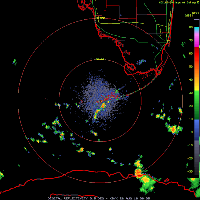
A weak area of low pressure located near the north coast of central
Cuba continues to produce a large area of disorganized cloudiness
and thunderstorms. Upper-level winds are not conducive for
significant development today while this system moves westward
through the Straits of Florida. The low is expected to move into
the southeastern Gulf of Mexico on Monday, where environmental
conditions could become somewhat more conducive for development.
Regardless of development, heavy rainfall and gusty winds are likely
over portions of the central and northwestern Bahamas, and Cuba
through tonight. Gusty winds and locally heavy rainfall will spread
into parts of southern Florida and the Florida Keys later today.
Interests elsewhere in Florida and the eastern Gulf of Mexico should
continue to monitor the progress of this disturbance. A NOAA
Hurricane Hunter aircraft is scheduled to investigate this system
this afternoon, if necessary.
* Formation chance through 48 hours...medium...40 percent
* Formation chance through 5 days...medium...60 percent
0 likes   
Visit the Caribbean-Central America Weather Thread where you can find at first post web cams,radars
and observations from Caribbean basin members Click Here

tolakram
Admin
Admin
Posts: 20027
Age: 62
Joined: Sun Aug 27, 2006 8:23 pm
Location: Florence, KY (name is Mark)

Re: ATL: INVEST 99L - Discussion

#3630 Postby tolakram » Sun Aug 28, 2016 6:44 am

Here's a faster loop from WU. Didn't I say I thought this was done yesterday? :oops:

Image
0 likes   
M a r k
- - - - -
Join us in chat: Storm2K Chatroom Invite. Android and IOS apps also available.

The posts in this forum are NOT official forecasts and should not be used as such. Posts are NOT endorsed by any professional institution or STORM2K.org. For official information and forecasts, please refer to NHC and NWS products.

User avatar
NDG
S2K Supporter
S2K Supporter
Posts: 15463
Joined: Sun Jul 09, 2006 10:14 pm
Location: Orlando, FL

Re: ATL: INVEST 99L - Discussion

#3631 Postby NDG » Sun Aug 28, 2016 6:50 am

Sounds like Brennan is siding with the GFS, of slower & weaker development than what the rest of the models show.
0 likes   

Frank P
S2K Supporter
S2K Supporter
Posts: 2777
Joined: Fri Aug 29, 2003 10:52 am
Location: Biloxi Beach, Ms
Contact:

Re: ATL: INVEST 99L - Discussion

#3632 Postby Frank P » Sun Aug 28, 2016 6:54 am

tolakram wrote:Here's a faster loop from WU. Didn't I say I thought this was done yesterday? :oops:

Image

Well that sure looks like a LLC just south of the Keys from that radar loop... heading due west.. or its spitting out another little vortex!
0 likes   

Dean4Storms
S2K Supporter
S2K Supporter
Posts: 6358
Age: 62
Joined: Sun Aug 31, 2003 1:01 pm
Location: Miramar Bch. FL

Re: ATL: INVEST 99L - Discussion

#3633 Postby Dean4Storms » Sun Aug 28, 2016 7:04 am

Frank P wrote:
tolakram wrote:Here's a faster loop from WU. Didn't I say I thought this was done yesterday? :oops:

[im g]http://i.imgur.com/60KCHTO.gif[/img]

Well that sure looks like a LLC just south of the Keys from that radar loop... heading due west.. or its spitting out another little vortex!


I think that is the LLC that formed yesterday south of Andros and has outraced the MLC once again. I think we've seen this several times now where a surface circulation gets going only to out run the overall MLC gyre.
1 likes   

Frank P
S2K Supporter
S2K Supporter
Posts: 2777
Joined: Fri Aug 29, 2003 10:52 am
Location: Biloxi Beach, Ms
Contact:

Re: ATL: INVEST 99L - Discussion

#3634 Postby Frank P » Sun Aug 28, 2016 7:09 am

If you look at the last few frames from the rapid scan vis it does hint of trying to form some new convection off to its NE and SE, with perhaps some banding features??? ... zoom and speed up..

https://www.ssec.wisc.edu/data/1min/ind ... height=700
0 likes   

User avatar
NDG
S2K Supporter
S2K Supporter
Posts: 15463
Joined: Sun Jul 09, 2006 10:14 pm
Location: Orlando, FL

Re: ATL: INVEST 99L - Discussion

#3635 Postby NDG » Sun Aug 28, 2016 7:12 am

It appears to me that the circulation just east of Key West is just yet another eddy rotating WSW around the larger circulation, mid level circulation is much closer now.
0 likes   

User avatar
ronjon
Category 5
Category 5
Posts: 4837
Joined: Fri Aug 19, 2005 5:17 pm
Location: Hernando Beach, FL

Re: ATL: INVEST 99L - Discussion

#3636 Postby ronjon » Sun Aug 28, 2016 7:24 am

Alyono wrote:development chances are increasing rapidly. May be close to 90% now


Alyono..what's your reasoning? Model consensus? Improved upper air forecasts? Your favorite model still keeping it weak.
0 likes   

User avatar
ronjon
Category 5
Category 5
Posts: 4837
Joined: Fri Aug 19, 2005 5:17 pm
Location: Hernando Beach, FL

Re: ATL: INVEST 99L - Discussion

#3637 Postby ronjon » Sun Aug 28, 2016 7:27 am

NDG wrote:It appears to me that the circulation just east of Key West is just yet another eddy rotating WSW around the larger circulation, mid level circulation is much closer now.


Agreed NDG. Thinking low pressure will have to eventually form underneath that mid level center. But it needs more convection to do that.
0 likes   

hipshot
Category 2
Category 2
Posts: 591
Joined: Tue Jul 06, 2010 9:18 pm
Location: Dallas, Texas

Re: ATL: INVEST 99L - Discussion

#3638 Postby hipshot » Sun Aug 28, 2016 7:29 am

From that rapid scan radar just posted, it seemed like the last few frames showed a fairly tight circulation due east of the cluster of
islands in the keys moving pretty much due west.
0 likes   

Frank P
S2K Supporter
S2K Supporter
Posts: 2777
Joined: Fri Aug 29, 2003 10:52 am
Location: Biloxi Beach, Ms
Contact:

Re: ATL: INVEST 99L - Discussion

#3639 Postby Frank P » Sun Aug 28, 2016 7:50 am

convection tops getting blown off, shear will prevent much from happening anytime soon... maybe another 24 hours or so... gee, been thinking that same thought for days on end... :eek:
0 likes   

User avatar
GCANE
S2K Supporter
S2K Supporter
Posts: 11617
Joined: Mon Oct 22, 2007 8:03 am

Re: ATL: INVEST 99L - Discussion

#3640 Postby GCANE » Sun Aug 28, 2016 7:52 am

Obviously getting a feed of dry air in from the north.
http://www.ssd.noaa.gov/PS/TROP/floater ... -long.html
Looks like skys are clear over much of S FL.
Expecting to see pop up convection this afternoon over FL feed into 99L and moisten the mid levels.
Could help develop it Sunday night.
0 likes   


Return to “2016”

Who is online

Users browsing this forum: No registered users and 21 guests