ATL: HERMINE - Post-Tropical - Discussion
Moderator: S2k Moderators


Re: ATL: INVEST 99L - Discussion
Think there's a natural convergence of trade winds in the straits that tends to slow these things down and fire more convection. It's slowly moving away from the shear zone east of the peninsula. Starting to some decent southerly inflow into it. Still needs to develop more intense convection to get a decent surface reflection.
0 likes
Re: ATL: INVEST 99L - Discussion
http://weather.cod.edu/satrad/?type=Carribbean-vis-1-24&checked=pfalls,vort&prodDim=100&overDim=100
A good way to track lower level vorticity. Notice how elongated it is.
A good way to track lower level vorticity. Notice how elongated it is.
1 likes
The posts in this forum are NOT official forecast and should not be used as such. They are just the opinion of the poster and may or may not be backed by sound meteorological data. They are NOT endorsed by any professional institution or storm2k.org. For official information, please refer to the NHC and NWS products.
Re: ATL: INVEST 99L - Discussion
This is why getting to the Gulf is the most important thing for 99L. All the southern inflow is being blocked by Cuba's mountains.
1 likes
The posts in this forum are NOT official forecast and should not be used as such. They are just the opinion of the poster and may or may not be backed by sound meteorological data. They are NOT endorsed by any professional institution or storm2k.org. For official information, please refer to the NHC and NWS products.

Re: ATL: INVEST 99L - Discussion
HurriGuy wrote:This is why getting to the Gulf is the most important thing for 99L. All the southern inflow is being blocked by Cuba's mountains.
and shear too.
1 likes
Robbielyn McCrary
I know just about enough to sound like I know what I'm talking about sometimes. But for your safety please follow the nhc for truly professional forecasting.
I know just about enough to sound like I know what I'm talking about sometimes. But for your safety please follow the nhc for truly professional forecasting.
-
tarheelprogrammer

- S2K Supporter

- Posts: 1793
- Joined: Mon Mar 28, 2016 9:25 pm
- Location: Raleigh, NC area (Garner, NC)
Re: ATL: INVEST 99L - Discussion
HurriGuy wrote:This is why getting to the Gulf is the most important thing for 99L. All the southern inflow is being blocked by Cuba's mountains.
Yes, but the environment in the Gulf of Mexico will not be much better with ULLs surrounding the system. Or am I incorrect?
0 likes
My posts are not official forecasts. They are just my opinion and may or may not be backed by sound meteorological data. They are NOT endorsed by any professional institution or storm2k.org. For official information, please refer to the NHC and NWS products.
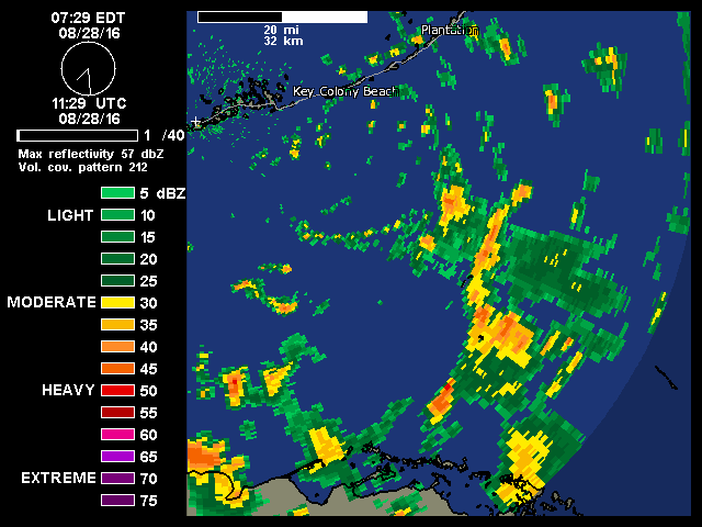
Re: ATL: INVEST 99L - Discussion
Lowest pressure on land is marathon in middle keys at 29.87 currently.
0 likes
-
tolakram
- Admin

- Posts: 20186
- Age: 62
- Joined: Sun Aug 27, 2006 8:23 pm
- Location: Florence, KY (name is Mark)
Re: ATL: INVEST 99L - Discussion
tarheelprogrammer wrote:HurriGuy wrote:This is why getting to the Gulf is the most important thing for 99L. All the southern inflow is being blocked by Cuba's mountains.
Yes, but the environment in the Gulf of Mexico will not be much better with ULLs surrounding the system. Or am I incorrect?
How will we know until it happens. The GFS says you are correct, every other model including the Euro says you are wrong. I honestly don't know, we have to wait and see. While we may not get a classic storm out of this it appears like a lot of rain falling over a large area, which can end up making a lot more people miserable.
1 likes
M a r k
- - - - -
Join us in chat: Storm2K Chatroom Invite. Android and IOS apps also available.
The posts in this forum are NOT official forecasts and should not be used as such. Posts are NOT endorsed by any professional institution or STORM2K.org. For official information and forecasts, please refer to NHC and NWS products.

Re: ATL: INVEST 99L - Discussion
Latest zoomed in radar loop, convection increasing just east of the circulation. The little eddy continues to track WSW now south of Key West.
Is a flip of a coin if the recon this afternoon will find a tight enough circulation to get upgraded to a TD. GFS & Euro are persistent that it will find much better UL conditions as soon as tomorrow over the extreme SE GOM.
Is a flip of a coin if the recon this afternoon will find a tight enough circulation to get upgraded to a TD. GFS & Euro are persistent that it will find much better UL conditions as soon as tomorrow over the extreme SE GOM.
1 likes
-
northjaxpro

- S2K Supporter
- Posts: 8900
- Joined: Mon Sep 27, 2010 11:21 am
- Location: Jacksonville, FL
Re: ATL: INVEST 99L - Discussion
HurriGuy wrote:This is why getting to the Gulf is the most important thing for 99L. All the southern inflow is being blocked by Cuba's mountains.
Spot on observation!!
1 likes
NEVER, EVER SAY NEVER in the tropics and weather in general, and most importantly, with life itself!!
________________________________________________________________________________________
Fay 2008 Beryl 2012 Debby 2012 Colin 2016 Hermine 2016 Julia 2016 Matthew 2016 Irma 2017 Dorian 2019
________________________________________________________________________________________
Fay 2008 Beryl 2012 Debby 2012 Colin 2016 Hermine 2016 Julia 2016 Matthew 2016 Irma 2017 Dorian 2019
-
cycloneye

- Admin
- Posts: 149508
- Age: 69
- Joined: Thu Oct 10, 2002 10:54 am
- Location: San Juan, Puerto Rico
Re: ATL: INVEST 99L - Recon
Plane going and departs at 1 PM EDT.
Hurricane Field Program Update – Sunday, Aug. 28, 2016 11AM Eastern
Posted on August 28, 2016 by noaahrd
OPERATIONS
Sunday, 28 Aug. 2016
NOAA43: Is scheduled to fly an NHC operationally tasked reconnaissance mission into AL99, the tropical disturbance located in the Florida Straits. This means that the National Hurricane Center requested this flight. Take off is scheduled for 1700 UTC (1PM Eastern) to and from MacDill Air Force Base, Tampa, FL. Two HRD scientists will be on this flight
1 likes
Visit the Caribbean-Central America Weather Thread where you can find at first post web cams,radars
and observations from Caribbean basin members Click Here
and observations from Caribbean basin members Click Here
Re: ATL: INVEST 99L - Discussion
The ULL to the north is not going to be tracking west for much longer unlike 99L.
Thats the difference. More west it goes, the better environment it will find. The ULL over Texas/LA has already stopped moving east.
Thats the difference. More west it goes, the better environment it will find. The ULL over Texas/LA has already stopped moving east.
0 likes
The posts in this forum are NOT official forecast and should not be used as such. They are just the opinion of the poster and may or may not be backed by sound meteorological data. They are NOT endorsed by any professional institution or storm2k.org. For official information, please refer to the NHC and NWS products.
Re: ATL: INVEST 99L - Discussion
What time is recon taking off? 2PM EDT?
0 likes
The posts in this forum are NOT official forecast and should not be used as such. They are just the opinion of the poster and may or may not be backed by sound meteorological data. They are NOT endorsed by any professional institution or storm2k.org. For official information, please refer to the NHC and NWS products.
-
GeneratorPower

- S2K Supporter
- Posts: 1648
- Age: 46
- Joined: Sun Dec 18, 2005 11:48 pm
- Location: Huntsville, AL
Re: ATL: INVEST 99L - Discussion
Lots of lighting in those storms southeast of Key West. Usually indicates strengthening storms.

0 likes
-
cycloneye
- Admin
- Posts: 149508
- Age: 69
- Joined: Thu Oct 10, 2002 10:54 am
- Location: San Juan, Puerto Rico
Re: ATL: INVEST 99L - Discussion
HurriGuy wrote:What time is recon taking off? 2PM EDT?
Departs at 1 PM EDT.
viewtopic.php?f=59&t=118173&p=2528938#p2528938
1 likes
Visit the Caribbean-Central America Weather Thread where you can find at first post web cams,radars
and observations from Caribbean basin members Click Here
and observations from Caribbean basin members Click Here
Re: ATL: INVEST 99L - Discussion
northjaxpro wrote:HurriGuy wrote:This is why getting to the Gulf is the most important thing for 99L. All the southern inflow is being blocked by Cuba's mountains.
Spot on observation!!
Western Cuban has high hills only around 1,500' at the highest, no high mountains like its eastern side.
1 likes
Re: ATL: INVEST 99L - Discussion
I cannot imagine recon finding anything we don't already know.
Tomorrow will be the big day
Tomorrow will be the big day
0 likes
The posts in this forum are NOT official forecast and should not be used as such. They are just the opinion of the poster and may or may not be backed by sound meteorological data. They are NOT endorsed by any professional institution or storm2k.org. For official information, please refer to the NHC and NWS products.

Re: ATL: INVEST 99L - Discussion
HurriGuy wrote:http://weather.cod.edu/satrad/?type=Carribbean-vis-0-24&checked=pfalls,vort&prodDim=100&overDim=100
Yeah vorticity is back southeast a tad.
Getting some towers firing off in the center of the latest vorticity. Cirrus from them is pushing off to the NW.
0 likes
Re: ATL: INVEST 99L - Discussion
http://www.ssd.noaa.gov/goes/comp/ceus/wv-animated.gif
This is absolutely insane.
Count the upper level lows and this doesn't include the one over the east Caribbean
This is absolutely insane.
Count the upper level lows and this doesn't include the one over the east Caribbean
Last edited by tolakram on Sun Aug 28, 2016 10:30 am, edited 2 times in total.
Reason: removed direct image link
Reason: removed direct image link
0 likes
The posts in this forum are NOT official forecast and should not be used as such. They are just the opinion of the poster and may or may not be backed by sound meteorological data. They are NOT endorsed by any professional institution or storm2k.org. For official information, please refer to the NHC and NWS products.
-
northjaxpro
- S2K Supporter
- Posts: 8900
- Joined: Mon Sep 27, 2010 11:21 am
- Location: Jacksonville, FL
Re: ATL: INVEST 99L - Discussion
NDG wrote:northjaxpro wrote:HurriGuy wrote:This is why getting to the Gulf is the most important thing for 99L. All the southern inflow is being blocked by Cuba's mountains.
Spot on observation!!
Western Cuban has high hills only around 1,500' at the highest, no high mountains like its eastern side.
Once this system gets far enough away from the influences of Cuba into the GOM and shear finally relaxes just a bit, 99L I I believe will finally get classified as a depression, probably within the next 24 hours
Last edited by northjaxpro on Sun Aug 28, 2016 10:34 am, edited 2 times in total.
0 likes
NEVER, EVER SAY NEVER in the tropics and weather in general, and most importantly, with life itself!!
________________________________________________________________________________________
Fay 2008 Beryl 2012 Debby 2012 Colin 2016 Hermine 2016 Julia 2016 Matthew 2016 Irma 2017 Dorian 2019
________________________________________________________________________________________
Fay 2008 Beryl 2012 Debby 2012 Colin 2016 Hermine 2016 Julia 2016 Matthew 2016 Irma 2017 Dorian 2019
Re: ATL: INVEST 99L - Discussion
GCANE wrote:HurriGuy wrote:http://weather.cod.edu/satrad/?type=Carribbean-vis-0-24&checked=pfalls,vort&prodDim=100&overDim=100
Yeah vorticity is back southeast a tad.
Getting some towers firing off in the center of the latest vorticity. Cirrus from them is pushing off to the NW.
Colder top on this one.
http://www.ssd.noaa.gov/PS/TROP/floater ... 0-lalo.gif
0 likes
Who is online
Users browsing this forum: No registered users and 73 guests