ATL: HERMINE - Post-Tropical - Discussion
Moderator: S2k Moderators
-
hurricanefloyd5

- Category 5

- Posts: 1659
- Age: 45
- Joined: Sun May 02, 2004 10:53 am
- Location: Spartanburg
- Contact:
Re: ATL: INVEST 99L - Discussion - 2 PM TWO up to 60%-80%
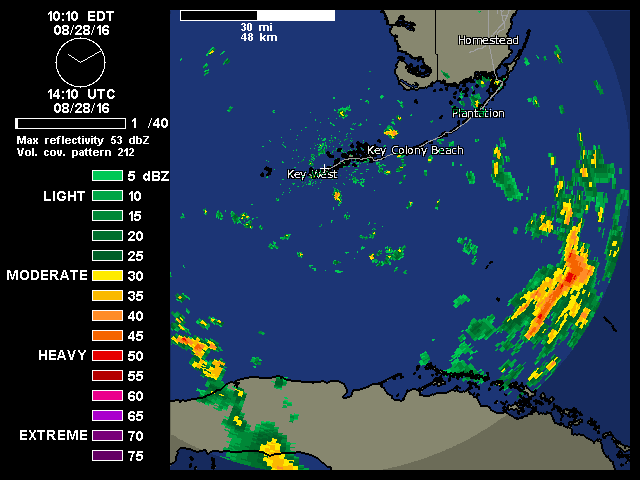
Can someone please post the Key West Radar on the board please
0 likes
-
wxman57

- Moderator-Pro Met

- Posts: 23175
- Age: 68
- Joined: Sat Jun 21, 2003 8:06 pm
- Location: Houston, TX (southwest)
Re: ATL: INVEST 99L - Discussion - 2 PM TWO up to 60%-80%
I see a weak, poorly-defined surface circulation center with squalls displaced well to the east. Doesn't qualify for a TD yet. I'm still thinking it will finally be classified on Tuesday afternoon's flight. Don't get me wrong, I REALLY want my forecast of development to verify. I've been issuing advisories on this thing since last Saturday, calling for development as it neared south Florida. Been at the office all day yesterday and all day today working it (and Eight). Don't want to miss a weekend off for nothing.  But I just don't see any development for at least another 24hrs, and probably not until Tuesday.
3 likes
Re: ATL: INVEST 99L - Discussion - 2 PM TWO up to 60%-80%
It's got that classic comma shape going.
0 likes
-
wxman57
- Moderator-Pro Met
- Posts: 23175
- Age: 68
- Joined: Sat Jun 21, 2003 8:06 pm
- Location: Houston, TX (southwest)
Re: ATL: INVEST 99L - Discussion - 2 PM TWO up to 60%-80%
hurricanefloyd5 wrote:Can someone please post the Key West Radar on the board please
http://radar.weather.gov/ridge/radar.php?rid=byx&product=N0R&overlay=11101111&loop=no
0 likes
-
CrazyC83
- Professional-Met

- Posts: 34315
- Joined: Tue Mar 07, 2006 11:57 pm
- Location: Deep South, for the first time!
Re: ATL: INVEST 99L - Recon
000
URNT15 KWBC 281754
NOAA3 05EEA INVEST HDOB 05 20160828
174430 2514N 08256W 9040 01001 0128 +216 +193 086024 025 025 000 00
174500 2512N 08257W 9045 00999 0129 +218 +196 085022 023 026 000 00
174530 2510N 08257W 9044 00996 0128 +217 +203 083019 020 026 000 00
174600 2508N 08258W 9045 00998 0128 +217 +203 077020 021 025 000 00
174630 2507N 08258W 9064 00975 0127 +215 +203 076020 021 025 000 00
174700 2505N 08258W 9044 00997 0126 +215 +195 071019 020 023 001 00
174730 2503N 08259W 9030 01005 0124 +218 +197 070018 018 023 000 03
174800 2503N 08301W 9261 00789 0125 +229 +209 063018 018 /// /// 03
174830 2504N 08302W 9436 00622 0125 +239 +215 061017 017 /// /// 03
174900 2506N 08301W 9554 00516 0126 +248 +224 059017 018 /// /// 03
174930 2505N 08300W 9677 00403 0126 +257 +230 058018 018 /// /// 03
175000 2504N 08258W 9681 00399 0127 +259 +232 057018 019 019 001 03
175030 2503N 08257W 9619 00453 0125 +255 +233 060018 019 027 000 00
175100 2503N 08255W 9696 00388 0126 +258 +234 054018 020 026 000 00
175130 2503N 08253W 9707 00374 0124 +262 +234 053019 021 026 000 00
175200 2502N 08251W 9707 00375 0124 +262 +234 055018 019 025 000 00
175230 2502N 08249W 9707 00375 0124 +263 +231 060019 019 026 000 00
175300 2502N 08247W 9707 00375 0125 +263 +232 058018 019 027 000 00
175330 2502N 08245W 9707 00374 0124 +264 +230 061020 021 027 000 00
175400 2502N 08243W 9707 00375 0124 +264 +233 059020 020 028 000 00
0 likes

Re: ATL: INVEST 99L - Discussion - 2 PM TWO up to 60%-80%
Just want to comment to those that skeptical about UL conditions over the SE GOM, the GFS & Euro have been very persistent in an UL ridge building over the SE GOM starting tonight into tomorrow morning and they have not backed away on the timing. Chances on the GFS & Euro failing on this forecasting within 24 hrs are slim to none, IMO.
0 likes
-
Evil Jeremy

- S2K Supporter

- Posts: 5463
- Age: 32
- Joined: Mon Apr 10, 2006 2:10 pm
- Location: Los Angeles, CA
Re: ATL: INVEST 99L - Discussion - 2 PM TWO up to 60%-80%
99L has me concerned. It's been an incredibly stubborn and resilient wave.... and I don't like those ingredients in a storm about to enter a more favorable environment.
Either way, this is the best it's looked all week.
Either way, this is the best it's looked all week.
0 likes
Frances 04 / Jeanne 04 / Katrina 05 / Wilma 05 / Fay 08 / Debby 12 / Andrea 13 / Colin 16 / Hermine 16 / Matthew 16 / Irma 17
Re: ATL: INVEST 99L - Discussion - 2 PM TWO up to 60%-80%
Climatology usually boosts systems like this as they track across the Florida Straits in late August. But this one seems to have a perpetual shear displacement tagging along with it. All you can do is watch. This one has enough characteristics to merit watching even though it appears to be lacking that final push to formation.
Disclaimer: Weather amateur. Refer to official sources for all tropical weather information.
Disclaimer: Weather amateur. Refer to official sources for all tropical weather information.
0 likes
Re: ATL: INVEST 99L - Discussion - 2 PM TWO up to 60%-80%
Latest Key West radar loop, I see the possible LLC SSE of Key West with the MLC still a little displaced to the SE of it, clearly seen on vis sat loop.
0 likes
-
hurricanefloyd5
- Category 5
- Posts: 1659
- Age: 45
- Joined: Sun May 02, 2004 10:53 am
- Location: Spartanburg
- Contact:
Re: ATL: INVEST 99L - Discussion - 2 PM TWO up to 60%-80%
wxman57 wrote:hurricanefloyd5 wrote:Can someone please post the Key West Radar on the board please
http://radar.weather.gov/ridge/radar.php?rid=byx&product=N0R&overlay=11101111&loop=no
I can't get it to loop threw the site. Need the loop on itself on the board
0 likes
-
Aric Dunn
- Category 5
- Posts: 21238
- Age: 43
- Joined: Sun Sep 19, 2004 9:58 pm
- Location: Ready for the Chase.
- Contact:
Re: ATL: INVEST 99L - Discussion
recon has descended. 30 more min or so.
0 likes
Note: If I make a post that is brief. Please refer back to previous posts for the analysis or reasoning. I do not re-write/qoute what my initial post said each time.
If there is nothing before... then just ask
Space & Atmospheric Physicist, Embry-Riddle Aeronautical University,
I believe the sky is falling...
If there is nothing before... then just ask
Space & Atmospheric Physicist, Embry-Riddle Aeronautical University,
I believe the sky is falling...
-
HurricaneBelle

- S2K Supporter
- Posts: 1209
- Joined: Sun Aug 27, 2006 6:12 pm
- Location: Clearwater, FL
Re: ATL: INVEST 99L - Discussion - 2 PM TWO up to 60%-80%
CrazyC83 wrote:HurriGuy wrote:CrazyC83 wrote:Regarding that potential hard hook, one thing I might be seeing is a combination of TD8 forcing a trough down and a ridge rebuilding over the western Gulf? I know it is weird for August (more of an October or November track) but regardless, forward motion should be slow.
Yep. Have been thinking this all week. 3 more days possible IMO over the Gulf. GFS slightly trending west ever so slightly each run.
I believe the stronger that TD8 gets (if we get a solid TS out of that) the stronger the steering influence will be. Not unlike when Bonnie opened up a trough for Charley (which was unseasonably strong to begin with).
Bonnie didn't open up a trough for Charley. Charley was a steered by an unusually strong mid-August mid-latitude trough that essentially sheared Bonnie to death, causing it to fall apart in the Panhandle. That trough and accompanying front was so strong that it brought dewpoints into the mid-50s in Pensacola at the same time Charley was making landfall in Punta Gorda. It was its anomalous strength that led to Charley going in further south than predicted, forcing a more NE turn than the NNE turn into Tampa that was originally expected.
1 likes
Re: ATL: INVEST 99L - Discussion - 2 PM TWO up to 60%-80%
hurricanefloyd5 wrote:wxman57 wrote:hurricanefloyd5 wrote:Can someone please post the Key West Radar on the board please
http://radar.weather.gov/ridge/radar.php?rid=byx&product=N0R&overlay=11101111&loop=no
I can't get it to loop threw the site. Need the loop on itself on the board
really long radar loop: http://flhurricane.com/imageanimator.php?217
0 likes
Re: ATL: INVEST 99L - Discussion
Still looks a mess but it's trying. most importantly, it's not giving up. Gets an "A" for tenacity.
0 likes
Re: ATL: INVEST 99L - Discussion
Recon already finding TS force winds, just west of possible LLC.
180330 2501N 08208W 9711 00366 0119 +261 +228 075030 030 037 000 00
180400 2501N 08206W 9711 00366 0119 +260 +229 078030 030 034 000 00
180330 2501N 08208W 9711 00366 0119 +261 +228 075030 030 037 000 00
180400 2501N 08206W 9711 00366 0119 +260 +229 078030 030 034 000 00
1 likes
-
Aric Dunn
- Category 5
- Posts: 21238
- Age: 43
- Joined: Sun Sep 19, 2004 9:58 pm
- Location: Ready for the Chase.
- Contact:
Re: ATL: INVEST 99L - Discussion
12z GFDL finally actually does something with it.. all models are now on board with at least a strong TS to well a major hurricane.
0 likes
Note: If I make a post that is brief. Please refer back to previous posts for the analysis or reasoning. I do not re-write/qoute what my initial post said each time.
If there is nothing before... then just ask
Space & Atmospheric Physicist, Embry-Riddle Aeronautical University,
I believe the sky is falling...
If there is nothing before... then just ask
Space & Atmospheric Physicist, Embry-Riddle Aeronautical University,
I believe the sky is falling...
-
CrazyC83
- Professional-Met
- Posts: 34315
- Joined: Tue Mar 07, 2006 11:57 pm
- Location: Deep South, for the first time!
Re: ATL: INVEST 99L - Recon
000
URNT15 KWBC 281804
NOAA3 05EEA INVEST HDOB 06 20160828
175430 2502N 08241W 9709 00371 0122 +263 +235 055020 021 028 000 00
175500 2502N 08240W 9707 00373 0123 +265 +234 061021 022 028 000 00
175530 2502N 08238W 9707 00372 0122 +266 +229 060020 021 028 000 00
175600 2501N 08236W 9707 00373 0122 +266 +229 061022 022 029 000 00
175630 2501N 08234W 9707 00372 0121 +266 +227 061023 023 028 000 00
175700 2501N 08232W 9708 00371 0121 +266 +229 059021 021 028 000 00
175730 2501N 08230W 9708 00372 0121 +266 +231 058020 021 027 000 00
175800 2501N 08228W 9708 00371 0121 +266 +228 064022 023 026 000 00
175830 2501N 08226W 9708 00370 0120 +266 +227 064022 023 027 000 00
175900 2501N 08225W 9707 00375 0122 +264 +229 069020 022 029 000 00
175930 2501N 08223W 9709 00371 0120 +261 +228 081019 020 029 000 00
180000 2501N 08221W 9710 00369 0120 +264 +231 069021 022 030 000 00
180030 2502N 08219W 9710 00368 0122 +257 +228 084025 027 031 000 00
180100 2502N 08217W 9709 00369 0120 +264 +220 073026 027 029 000 00
180130 2502N 08215W 9711 00367 0119 +263 +231 074024 025 026 000 00
180200 2501N 08213W 9709 00368 0119 +263 +235 079024 025 024 000 00
180230 2501N 08212W 9710 00367 0119 +264 +235 077024 026 027 000 00
180300 2501N 08210W 9706 00371 0120 +259 +234 075027 030 034 000 00
180330 2501N 08208W 9711 00366 0119 +261 +228 075030 030 037 000 00
180400 2501N 08206W 9711 00366 0119 +260 +229 078030 030 034 000 00
We have TS winds, just need an LLC.
0 likes

-
HurricaneBelle
- S2K Supporter
- Posts: 1209
- Joined: Sun Aug 27, 2006 6:12 pm
- Location: Clearwater, FL
Re: ATL: INVEST 99L - Discussion - 2 PM TWO up to 60%-80%
HurricaneBelle wrote:CrazyC83 wrote:HurriGuy wrote:
Yep. Have been thinking this all week. 3 more days possible IMO over the Gulf. GFS slightly trending west ever so slightly each run.
I believe the stronger that TD8 gets (if we get a solid TS out of that) the stronger the steering influence will be. Not unlike when Bonnie opened up a trough for Charley (which was unseasonably strong to begin with).
Bonnie didn't open up a trough for Charley. Charley was a steered by an unusually strong mid-August mid-latitude trough that essentially sheared Bonnie to death, causing it to fall apart in the Panhandle. That trough and accompanying front was so strong that it brought dewpoints into the mid-50s in Pensacola at the same time Charley was making landfall in Punta Gorda. It was its anomalous strength that led to Charley going in further south than predicted, forcing a more NE turn than the NNE turn into Tampa that was originally expected.
In fact that trough was so strong it pretty much did Charley in as well once it emerged off the east coast of Florida. Charley was forecast to be a problem all the way up the East Coast (essentially Donna redux) but once it started interacting with the trough Charley never recovered anything close its former strength and barely brought hurricane conditions to a small part NC before pretty much washing out east of the Delmarva. That trough was one for the ages given the time of year.
0 likes
-
Aric Dunn
- Category 5
- Posts: 21238
- Age: 43
- Joined: Sun Sep 19, 2004 9:58 pm
- Location: Ready for the Chase.
- Contact:
Re: ATL: INVEST 99L - Discussion
NDG wrote:Recon already finding TS force winds, just west of possible LLC.
180330 2501N 08208W 9711 00366 0119 +261 +228 075030 030 037 000 00
180400 2501N 08206W 9711 00366 0119 +260 +229 078030 030 034 000 00
they are north of the keys still not sure what their operational altitude will be. check reports in the keys for obs.
0 likes
Note: If I make a post that is brief. Please refer back to previous posts for the analysis or reasoning. I do not re-write/qoute what my initial post said each time.
If there is nothing before... then just ask
Space & Atmospheric Physicist, Embry-Riddle Aeronautical University,
I believe the sky is falling...
If there is nothing before... then just ask
Space & Atmospheric Physicist, Embry-Riddle Aeronautical University,
I believe the sky is falling...
Who is online
Users browsing this forum: No registered users and 51 guests