
Your center of circulation, I was pretty close to my earlier estimate. Now recon gaining altitude before going through the thunderstorms.
193800 2344N 08141W 9768 00287 0087 +259 +245 259005 006 020 000 00
193830 2345N 08140W 9769 00285 0088 +260 +243 248006 006 020 000 00
193900 2347N 08139W 9768 00287 0089 +258 +241 206004 004 021 000 00
ATL: HERMINE - Post-Tropical - Discussion
Moderator: S2k Moderators
Re: ATL: INVEST 99L - Discussion
0 likes
-
TropicalSailor

- Tropical Depression

- Posts: 94
- Joined: Thu Aug 25, 2016 8:24 am
- Location: Panama City Beach, FL
Re: ATL: INVEST 99L - Discussion
stormhunter7 wrote:looks like lowest pressure miss piggy found just north of cuba was 1009mb. The center or what could be a center may be closer to coast, but we probably don't have permission to be that close to their air space? OR we didn't ask to enter Cuban airspace?
It appears to me they were right at the center?
0 likes
Re: ATL: INVEST 99L - Discussion

Last edited by rockyman on Sun Aug 28, 2016 2:58 pm, edited 2 times in total.
0 likes
-
SeGaBob
Re: ATL: INVEST 99L - Discussion
NDG wrote:Your center of circulation, I was pretty close to my earlier estimate. Now recon gaining altitude before going through the thunderstorms.
193800 2344N 08141W 9768 00287 0087 +259 +245 259005 006 020 000 00
193830 2345N 08140W 9769 00285 0088 +260 +243 248006 006 020 000 00
193900 2347N 08139W 9768 00287 0089 +258 +241 206004 004 021 000 00
Is this the part where they find the max winds?
0 likes
-
LSU2001

- S2K Supporter

- Posts: 1711
- Age: 58
- Joined: Sat Sep 11, 2004 11:01 pm
- Location: Cut Off, Louisiana
Re: ATL: INVEST 99L - Discussion
Frank or Chaser1,
Could one of you post the link to the donation page? I cant seem to find it in announcements.
thanks,
tim
Could one of you post the link to the donation page? I cant seem to find it in announcements.
thanks,
tim
1 likes
Personal Forecast Disclaimer:
The posts in this forum are NOT official forecast and should not be used as such. They are NOT endorsed by any professional institution or storm2k.org. For official information, please refer to the NHC and NWS products.
The posts in this forum are NOT official forecast and should not be used as such. They are NOT endorsed by any professional institution or storm2k.org. For official information, please refer to the NHC and NWS products.
-
Aric Dunn
- Category 5

- Posts: 21238
- Age: 43
- Joined: Sun Sep 19, 2004 9:58 pm
- Location: Ready for the Chase.
- Contact:
Re: ATL: INVEST 99L - Discussion
according recon .. the center is about right here. with convection building again around it.

0 likes
Note: If I make a post that is brief. Please refer back to previous posts for the analysis or reasoning. I do not re-write/qoute what my initial post said each time.
If there is nothing before... then just ask
Space & Atmospheric Physicist, Embry-Riddle Aeronautical University,
I believe the sky is falling...
If there is nothing before... then just ask
Space & Atmospheric Physicist, Embry-Riddle Aeronautical University,
I believe the sky is falling...
-
deltadog03

- Professional-Met

- Posts: 3580
- Joined: Tue Jul 05, 2005 6:16 pm
- Location: Macon, GA
Re: ATL: INVEST 99L - Discussion
IMO, not any official stuff, I would upgrade to a TD, why? We know it's got a LLC that's producing sustained convection, and with an increasingly favorable environment I would do if.
3 likes
-
Rail Dawg
- S2K Supporter
- Posts: 326
- Joined: Mon Aug 27, 2012 5:02 pm
- Location: Where the eye makes landfall.
Re: ATL: INVEST 99L - Discussio
This video is a view of Invest 99L from 38,000 ft about 120 miles west of Invest 99L.
It was taken at 1pm EST today the 28th.
https://www.dropbox.com/s/bdn5ckaegsafxrd/IMG_0121.MOV
I'm learning how to post videos here.
You could see the storms being sheared from it looks like the south.
Any thoughts or opinions appreciated!
Chuck
It was taken at 1pm EST today the 28th.
https://www.dropbox.com/s/bdn5ckaegsafxrd/IMG_0121.MOV
I'm learning how to post videos here.
You could see the storms being sheared from it looks like the south.
Any thoughts or opinions appreciated!
Chuck
Last edited by Rail Dawg on Sun Aug 28, 2016 3:04 pm, edited 1 time in total.
10 likes
Although I have been a hurricane forecaster since 1980 that only means I've been wrong lots of times.
-
stormhunter7

- Category 2

- Posts: 763
- Joined: Mon May 26, 2008 3:13 pm
- Location: Panama City Beach, Florida
- Contact:
Re: ATL: INVEST 99L - Discussion
nah, they hit a surface center it appears at 1kft. So we will have much better data now, and we do have west winds. So technically it meets TD classification, but lacks true stroms. NHC may hold for convection to blow up over coc, i think.
0 likes
The following post is NOT an official forecast and should not be used as such. It is just the opinion of the poster and may or may not be backed by sound meteorological data. It is NOT endorsed by any professional institution including storm2k.org For Official Information please refer to the NHC and NWS products. http://www.nhc.noaa.gov
-
bob rulz
- Category 5
- Posts: 1711
- Age: 36
- Joined: Sat Jan 28, 2006 7:30 pm
- Location: Salt Lake City, Utah
Re: ATL: INVEST 99L - Discussion
Convection fired up very rapidly around that LLC. I'm not sure there's anything now that would prevent this from being designated, right?
Just as I warned a few days ago....too many people writing this off before entering that giant bathtub called the Gulf of Mexico.
Just as I warned a few days ago....too many people writing this off before entering that giant bathtub called the Gulf of Mexico.
0 likes
-
CrazyC83
- Professional-Met
- Posts: 34315
- Joined: Tue Mar 07, 2006 11:57 pm
- Location: Deep South, for the first time!
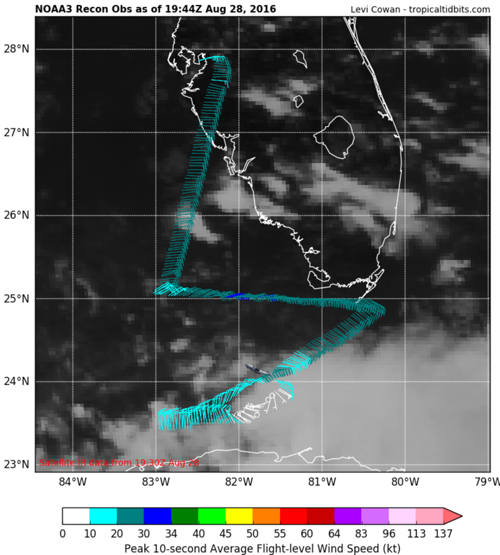
Re: ATL: INVEST 99L - Recon
000
URNT15 KWBC 281954
NOAA3 05EEA INVEST HDOB 17 20160828
194430 2402N 08136W 9617 00425 0093 +243 +227 103013 015 023 000 00
194500 2402N 08139W 9765 00292 0092 +251 +235 097016 016 026 000 00
194530 2402N 08141W 9770 00287 0092 +255 +234 089016 016 024 000 00
194600 2402N 08143W 9769 00289 0093 +254 +238 081014 015 024 000 00
194630 2402N 08145W 9769 00288 0092 +255 +240 079015 016 024 000 00
194700 2402N 08147W 9770 00288 0091 +259 +228 070017 018 025 000 00
194730 2402N 08149W 9769 00289 0092 +257 +234 066017 018 026 000 00
194800 2402N 08152W 9769 00290 0092 +257 +240 064016 017 026 000 00
194830 2402N 08154W 9770 00287 0092 +258 +239 069015 016 026 000 00
194900 2402N 08156W 9770 00288 0092 +258 +240 066016 016 026 000 00
194930 2402N 08158W 9773 00285 0093 +261 +238 067016 016 025 000 00
195000 2402N 08200W 9770 00290 0092 +262 +241 063016 016 023 000 00
195030 2402N 08202W 9771 00287 0091 +263 +239 060015 016 024 000 00
195100 2402N 08204W 9770 00290 0093 +263 +241 058016 017 025 000 00
195130 2402N 08207W 9771 00288 0092 +264 +242 057015 015 025 000 00
195200 2401N 08209W 9770 00289 0093 +264 +243 051015 015 025 000 03
195230 2359N 08209W 9770 00288 0091 +264 +244 042013 013 014 000 03
195300 2358N 08208W 9771 00286 0090 +265 +238 036014 015 020 000 00
195330 2356N 08207W 9770 00286 0090 +266 +236 040015 015 021 000 00
195400 2355N 08206W 9770 00287 0090 +264 +238 050014 015 021 000 00
0 likes
-
Frank P
- S2K Supporter
- Posts: 2779
- Joined: Fri Aug 29, 2003 10:52 am
- Location: Biloxi Beach, Ms
- Contact:
Re: ATL: INVEST 99L - Discussion
LSU2001 wrote:Frank or Chaser1,
Could one of you post the link to the donation page? I cant seem to find it in announcements.
thanks,
tim
Go to the board Index LSU, you will see it there.. under Rules and Announcements
Last edited by Frank P on Sun Aug 28, 2016 3:01 pm, edited 1 time in total.
1 likes
-
Portastorm

- Storm2k Moderator

- Posts: 9955
- Age: 63
- Joined: Fri Jul 11, 2003 9:16 am
- Location: Round Rock, TX
- Contact:
Re: ATL: INVEST 99L - Discussion
Rail Dawg wrote:This video is a view of Invest 99L from 38,000 ft about 120 miles west of Key West, FL.
It was taken at 1pm EST today the 28th.
https://www.dropbox.com/s/bdn5ckaegsafxrd/IMG_0121.MOV
I'm learning how to post videos here.
You could see the storms being sheared from it looks like the south.
Any thoughts or opinions appreciated!
Chuck
How far have we come at Storm2k? Hell, we have our OWN recon pilots now!
Thanks Rail Dawg for your comments earlier today and for sharing this video. Happy landings in Cancun!
10 likes
Any forecasts under my name are to be taken with a grain of salt. Get your best forecasts from the National Weather Service and National Hurricane Center.
-
bob rulz
- Category 5
- Posts: 1711
- Age: 36
- Joined: Sat Jan 28, 2006 7:30 pm
- Location: Salt Lake City, Utah
Re: ATL: INVEST 99L - Discussion
What's the strongest a storm that formed IN the Gulf has become?
0 likes
-
stormhunter7
- Category 2
- Posts: 763
- Joined: Mon May 26, 2008 3:13 pm
- Location: Panama City Beach, Florida
- Contact:
Re: ATL: INVEST 99L - Discussion
Rail Dawg wrote:This video is a view of Invest 99L from 38,000 ft about 120 miles west of Key West, FL.
It was taken at 1pm EST today the 28th.
https://www.dropbox.com/s/bdn5ckaegsafxrd/IMG_0121.MOV
I'm learning how to post videos here.
You could see the storms being sheared from it looks like the south.
Any thoughts or opinions appreciated!
Chuck
If you make a youtube channel, then you can post directly from your smartphone. Just make sure you using WIFI, as it will eat you cell data up fast. lol Once posted to your youtube, just copy url.
Awesome job shooting horizontal too!
1 likes
The following post is NOT an official forecast and should not be used as such. It is just the opinion of the poster and may or may not be backed by sound meteorological data. It is NOT endorsed by any professional institution including storm2k.org For Official Information please refer to the NHC and NWS products. http://www.nhc.noaa.gov

Re: ATL: INVEST 99L - Discussion
Tireman4 wrote:Just a reminder. The pro mets that come on here are doing it because they want to, not have to. I am not a moderator, but I respect their opinion. They have the right see things different ways.
I agree the pro mets are awesome! I appreciate all their hard work and their opinions. I have learned so much from them over the last several years. Kudos to all of them!
3 likes
-
northjaxpro

- S2K Supporter
- Posts: 8900
- Joined: Mon Sep 27, 2010 11:21 am
- Location: Jacksonville, FL
Re: ATL: INVEST 99L - Discussion
Amazing that after 190 pages over 3700 posts on 99L , it appears FINALLY, we may FINALLY see this system classified as a Tropical Depression after nearly following this for 11 days.
EDIT: make that over 3800 posts to this juncture.
EDIT: make that over 3800 posts to this juncture.
Last edited by northjaxpro on Sun Aug 28, 2016 3:08 pm, edited 1 time in total.
3 likes
NEVER, EVER SAY NEVER in the tropics and weather in general, and most importantly, with life itself!!
________________________________________________________________________________________
Fay 2008 Beryl 2012 Debby 2012 Colin 2016 Hermine 2016 Julia 2016 Matthew 2016 Irma 2017 Dorian 2019
________________________________________________________________________________________
Fay 2008 Beryl 2012 Debby 2012 Colin 2016 Hermine 2016 Julia 2016 Matthew 2016 Irma 2017 Dorian 2019
-
TropicalSailor
- Tropical Depression
- Posts: 94
- Joined: Thu Aug 25, 2016 8:24 am
- Location: Panama City Beach, FL
Re: ATL: INVEST 99L - Discussion
stormhunter7 wrote:nah, they hit a surface center it appears at 1kft. So we will have much better data now, and we do have west winds. So technically it meets TD classification, but lacks true stroms. NHC may hold for convection to blow up over coc, i think.
I'm sorry but I don't understanding holding this off a TD when we are this closed to land. That's a big risk IMO
1 likes
Re: ATL: INVEST 99L - Discussion
bob rulz wrote:Convection fired up very rapidly around that LLC. I'm not sure there's anything now that would prevent this from being designated, right?
Just as I warned a few days ago....too many people writing this off before entering that giant bathtub called the Gulf of Mexico.
If they don't do it my guess would be persistence and organization. An equally if not more compelling case could have been made for an upgrade back near Guadeloupe. at any rate I'll sit and wait for a verdict...
0 likes
Who is online
Users browsing this forum: No registered users and 36 guests