ATL: HERMINE - Post-Tropical - Discussion
Moderator: S2k Moderators

Re: ATL: NINE - Tropical Depression - Discussion
Alright, NOAA...we need to let the crew rest tonight and setup daily synoptic sampling until landfall in addition to normal recon. The models are night and day right now. The ensemble mean for the Euro was lower than the operational (not by a lot though). There are a number models taking a hurricane into the coast. They need more and better sampling.
0 likes
-
Dean4Storms
- S2K Supporter

- Posts: 6358
- Age: 63
- Joined: Sun Aug 31, 2003 1:01 pm
- Location: Miramar Bch. FL
Re: ATL: NINE - Tropical Depression - Discussion
Just 5kts of wind shear just to the west of TD9, I think it steadily deepens with the water there so warm.
0 likes
-
LSU2001

- S2K Supporter
- Posts: 1711
- Age: 58
- Joined: Sat Sep 11, 2004 11:01 pm
- Location: Cut Off, Louisiana
Re: ATL: NINE - Tropical Depression - Discussion
I hope you are dead wrong Dean,
I do not want a steadily deepening storm in the gulf.
but unfortunately I have a feeling you are right.
TIm
I do not want a steadily deepening storm in the gulf.
but unfortunately I have a feeling you are right.
TIm
Last edited by LSU2001 on Sun Aug 28, 2016 4:37 pm, edited 1 time in total.
1 likes
Personal Forecast Disclaimer:
The posts in this forum are NOT official forecast and should not be used as such. They are NOT endorsed by any professional institution or storm2k.org. For official information, please refer to the NHC and NWS products.
The posts in this forum are NOT official forecast and should not be used as such. They are NOT endorsed by any professional institution or storm2k.org. For official information, please refer to the NHC and NWS products.

Re: ATL: NINE - Tropical Depression - Discussion
Can someone answer my question of what meterological factors the right hand turn in the GOM is being based on?
0 likes
Re: ATL: NINE - Tropical Depression - Discussion
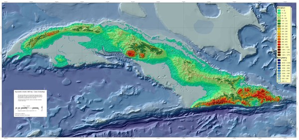
Cuba's mountains on the west side look really close to the coast looking at his map. Given the WSW motion of the circulation, it is no wonder the circulation is becoming more defined as the winds are coming down and most likely displaced to the west.
I am no expert at this, but Cuba probably had a good role in relocating the center back towards the convection.
1 likes
The posts in this forum are NOT official forecast and should not be used as such. They are just the opinion of the poster and may or may not be backed by sound meteorological data. They are NOT endorsed by any professional institution or storm2k.org. For official information, please refer to the NHC and NWS products.
-
LSU2001
- S2K Supporter
- Posts: 1711
- Age: 58
- Joined: Sat Sep 11, 2004 11:01 pm
- Location: Cut Off, Louisiana
Re: ATL: NINE - Tropical Depression - Discussion
"Can someone answer my question of what meterological factors the right hand turn in the GOM is being based on?"
A trough dropping down on the east coast is supposed to pick up the weak storm and pull it northeast. A strong storm will probably head more west, weak storm more northeast.
That is if the trough picks it up at all and the ridge don't build back quicker than anticipated
A trough dropping down on the east coast is supposed to pick up the weak storm and pull it northeast. A strong storm will probably head more west, weak storm more northeast.
That is if the trough picks it up at all and the ridge don't build back quicker than anticipated
0 likes
Personal Forecast Disclaimer:
The posts in this forum are NOT official forecast and should not be used as such. They are NOT endorsed by any professional institution or storm2k.org. For official information, please refer to the NHC and NWS products.
The posts in this forum are NOT official forecast and should not be used as such. They are NOT endorsed by any professional institution or storm2k.org. For official information, please refer to the NHC and NWS products.

Re: ATL: NINE - Tropical Depression - Discussion
System is intensifying.
Check the pressure drop at Sand Key
http://www.ndbc.noaa.gov/plot_met.php?s ... _label=EDT
Check the pressure drop at Sand Key
http://www.ndbc.noaa.gov/plot_met.php?s ... _label=EDT
0 likes
Re: ATL: NINE - Tropical Depression - Discussion
TD9 (so used to typing 99L i had to correct myself...  ) is going to trek over the highest TCHP in the GoM in the next 24 hours...
It may serve as a bridge to the better upper level conditions.
It may serve as a bridge to the better upper level conditions.
1 likes
Re: ATL: NINE - Tropical Depression - Discussion
One other thing worth remembering is that storms are often right loaded...someone 75 or 100 miles east of the center may get more weather than someone 25 miles to the west. pay attention to asymmetry. Just something to keep in the back of your mind..
1 likes
-
Dean4Storms
- S2K Supporter
- Posts: 6358
- Age: 63
- Joined: Sun Aug 31, 2003 1:01 pm
- Location: Miramar Bch. FL
Re: ATL: NINE - Tropical Depression - Discussion
Does appear that the LLC is being pulled WSW and maybe a Pro Met. can chime in here but I believe an LLC can get pulled in the direction of land due to surface wind friction where the center is trying to balance out the loss due to the friction. I remember that was the reason given for Charley's sudden pull to the right when it was headed more toward Sarasota area but instead turned right a bit and went ashore closer to Ft. Myers.
Maybe that is what we are seeing with this LLC, friction from Cuba causing the LLC to try and make up the difference with its wind field on its southern periphery.
Maybe that is what we are seeing with this LLC, friction from Cuba causing the LLC to try and make up the difference with its wind field on its southern periphery.
0 likes
Re: ATL: NINE - Tropical Depression - Discussion
LSU2001 wrote:"Can someone answer my question of what meterological factors the right hand turn in the GOM is being based on?"
A trough dropping down on the east coast is supposed to pick up the weak storm and pull it northeast. A strong storm will probably head more west, weak storm more northeast.
That is if the trough picks it up at all and the ridge don't build back quicker than anticipated
Thanks!!
0 likes
-
CrazyC83
- Professional-Met

- Posts: 34315
- Joined: Tue Mar 07, 2006 11:57 pm
- Location: Deep South, for the first time!
Re: ATL: NINE - Recon
000
URNT15 KWBC 282134
NOAA3 05EEA INVEST HDOB 27 20160828
212430 2402N 08135W 9606 00439 0096 +240 +211 128024 026 027 000 00
212500 2400N 08135W 9606 00438 0096 +239 +214 127022 022 028 000 00
212530 2359N 08135W 9605 00439 0096 +237 +212 138022 022 028 000 00
212600 2357N 08136W 9606 00437 0094 +233 +220 141024 025 028 000 03
212630 2357N 08138W 9606 00437 0095 +233 +222 137024 025 028 000 00
212700 2357N 08140W 9605 00441 0097 +237 +209 137023 024 028 000 00
212730 2357N 08143W 9606 00439 0096 +234 +221 122021 022 029 000 00
212800 2358N 08145W 9606 00438 0094 +238 +209 123024 025 029 000 00
212830 2358N 08147W 9606 00437 0093 +237 +212 121025 027 032 000 00
212900 2358N 08149W 9603 00439 0093 +236 +219 124026 026 032 000 00
212930 2358N 08151W 9606 00437 0092 +238 +225 114024 025 030 000 00
213000 2358N 08154W 9603 00438 0092 +239 +229 108024 024 029 000 00
213030 2358N 08156W 9606 00436 0092 +240 +228 105024 025 030 000 00
213100 2358N 08158W 9604 00438 0091 +242 +231 100023 023 029 000 00
213130 2358N 08200W 9605 00437 0091 +244 +229 094023 023 030 000 00
213200 2358N 08203W 9605 00437 0091 +244 +230 091022 023 028 000 00
213230 2358N 08205W 9597 00442 0086 +244 +232 084021 022 029 000 00
213300 2358N 08207W 9601 00438 0087 +246 +230 081019 020 025 001 00
213330 2358N 08209W 9591 00443 0084 +246 +227 075019 019 026 000 00
213400 2358N 08211W 9591 00443 0085 +246 +232 071017 018 025 000 03
0 likes
Re: ATL: NINE - Tropical Depression - Discussion
The GFS did a weird wobble north from hour 18 to hour 24.
Something like that can make all the difference in the eventual outcome. I would be weary
Something like that can make all the difference in the eventual outcome. I would be weary
0 likes
The posts in this forum are NOT official forecast and should not be used as such. They are just the opinion of the poster and may or may not be backed by sound meteorological data. They are NOT endorsed by any professional institution or storm2k.org. For official information, please refer to the NHC and NWS products.
-
LSU2001
- S2K Supporter
- Posts: 1711
- Age: 58
- Joined: Sat Sep 11, 2004 11:01 pm
- Location: Cut Off, Louisiana
Re: ATL: NINE - Tropical Depression - Discussion
GCANE wrote:System is intensifying.
Check the pressure drop at Sand Key
http://www.ndbc.noaa.gov/plot_met.php?s ... _label=EDT
not really, the chart is showing 29.80 inches of mercury and the conversion to millibars equals 1009.14 so that is what the hurricane hunters reported
0 likes
Personal Forecast Disclaimer:
The posts in this forum are NOT official forecast and should not be used as such. They are NOT endorsed by any professional institution or storm2k.org. For official information, please refer to the NHC and NWS products.
The posts in this forum are NOT official forecast and should not be used as such. They are NOT endorsed by any professional institution or storm2k.org. For official information, please refer to the NHC and NWS products.
-
ConvergenceZone
.gif)
- Category 5

- Posts: 5241
- Joined: Fri Jul 29, 2005 1:40 am
- Location: Northern California
Re: ATL: NINE - Tropical Depression - Discussion
So I'm officially eating a large plate of Crow right now for Lunch. It's kind of bitter..........I
Congratz to those who did predicted development.........
Also, Wxman, didn't officially call "bones" on this, he only said it was close, so no Crow for him, lucky guy! lol
(Since the board is getting busy, I decided not to paste in a picture of a crow, as the servers are going to have a heavy load, and don't need extra graphics).
2 likes
-
Hurricane Andrew

- S2K Supporter
- Posts: 1891
- Age: 27
- Joined: Sun May 23, 2010 2:53 pm
- Location: KS
Re: ATL: NINE - Tropical Depression - Discussion
I believe we can now see the LLC...just to the nw of the new convective burst. Until the LLC Is firmly relocated under the convection, I don't expect much in the way of Intensification.
https://www.ssec.wisc.edu/data/1min/ind ... eight=1500
https://www.ssec.wisc.edu/data/1min/ind ... eight=1500
0 likes
The Enthusiast
NREMT-AEMT, WX nerd
Irene '11, Sandy '12, Irma '17 (SAR)
"Hard to think we were born to live this way..." -Wage War
-
CrazyC83
- Professional-Met
- Posts: 34315
- Joined: Tue Mar 07, 2006 11:57 pm
- Location: Deep South, for the first time!
Re: ATL: NINE - Recon
000
URNT15 KWBC 282144
NOAA3 05EEA INVEST HDOB 28 20160828
213430 2356N 08212W 9597 00441 0087 +247 +232 064017 017 024 000 03
213500 2354N 08211W 9596 00443 0087 +246 +233 060017 018 023 000 03
213530 2353N 08209W 9592 00444 0084 +247 +232 061018 018 023 000 00
213600 2352N 08208W 9592 00443 0084 +246 +235 059018 018 023 000 00
213630 2350N 08206W 9597 00440 0085 +247 +236 058017 018 021 000 00
213700 2349N 08205W 9596 00439 0083 +247 +234 055016 017 021 000 00
213730 2348N 08204W 9588 00445 0082 +249 +232 060014 014 019 000 00
213800 2346N 08202W 9599 00436 0084 +250 +235 061013 014 019 000 00
213830 2345N 08201W 9590 00444 0083 +251 +226 062012 012 018 000 00
213900 2344N 08200W 9587 00447 0083 +250 +230 066010 010 017 000 03
213930 2342N 08159W 9559 00476 0087 +248 +231 061009 010 018 000 00
214000 2340N 08158W 9552 00484 0085 +246 +229 068008 008 019 000 00
214030 2338N 08158W 9541 00491 0086 +244 +234 085008 008 024 003 03
214100 2337N 08157W 9534 00496 0084 +244 +228 104011 014 021 013 00
214130 2335N 08156W 9553 00477 0086 +238 //// 077007 010 031 022 01
214200 2333N 08155W 9528 00499 0084 +237 +237 184004 006 043 044 00
214230 2332N 08154W 9590 00442 0086 +226 //// 312006 009 049 068 01
214300 2330N 08154W 9528 00498 0086 +230 +229 239010 012 049 053 00
214330 2328N 08153W 9534 00498 0086 +234 //// 225010 013 040 037 01
214400 2327N 08151W 9485 00546 0087 +237 //// 174013 016 032 013 01
The SFMR readings seem fishy as they were taken in torrential rain.
1 likes
Re: ATL: NINE - Tropical Depression - Discussion
Slight improvement in surface spiral in my opinion...
0 likes
-
Dean4Storms
- S2K Supporter
- Posts: 6358
- Age: 63
- Joined: Sun Aug 31, 2003 1:01 pm
- Location: Miramar Bch. FL
Re: ATL: NINE - Tropical Depression - Discussion
Yes, the MLC is still back SW of Andros Island, clearly visible rotation there on speed up imagery. Still a ways to go for any kind of rapid intensification if it ever does!
0 likes
-
stormhunter7

- Category 2

- Posts: 763
- Joined: Mon May 26, 2008 3:13 pm
- Location: Panama City Beach, Florida
- Contact:
Re: ATL: NINE - Tropical Depression - Discussion
bad sign is explosion of storms now over center.. watching 1 min vis and its right over center. no shear near center
0 likes
The following post is NOT an official forecast and should not be used as such. It is just the opinion of the poster and may or may not be backed by sound meteorological data. It is NOT endorsed by any professional institution including storm2k.org For Official Information please refer to the NHC and NWS products. http://www.nhc.noaa.gov
Who is online
Users browsing this forum: No registered users and 12 guests