ATL: HERMINE - Post-Tropical - Discussion
Moderator: S2k Moderators
-
gatorcane

- S2K Supporter

- Posts: 23708
- Age: 48
- Joined: Sun Mar 13, 2005 3:54 pm
- Location: Boca Raton, FL
Re: ATL: NINE - Tropical Depression - Discussion
Quite chaotic looking at this SAT loop - ULL approaching NE Florida, another disturbance approaching LA, outflow boundary moving offshore west coast of Florida, TD #8 in the upper-right-hand corner, and messy TD-9 with low-level and mid-level LLCs displaced.
http://rammb.cira.colostate.edu/ramsdis ... display=12
http://rammb.cira.colostate.edu/ramsdis ... display=12
1 likes
-
bamajammer4eva
- Category 4

- Posts: 907
- Joined: Sun Apr 18, 2010 3:21 am
- Location: Ozark, AL
Re: ATL: NINE - Tropical Depression - Discussion
Ship report at 24.3/82.9 showing 1007.5 MB in GRLevel3
0 likes


Re: ATL: INVEST 99L - Discussion
Hammy wrote:NDG wrote:Hammy wrote:
Not necessarily, I've seen a VDM numerous times without one, especially if the winds are fairly weak still.
Hammy, every time you try to prove me wrong is a fail, but I respect your opinion
Looks like we're adding another to the list
Should we get better model output now that this has actually formed starting with the 00z-12z runs?
Hopefully, at least in the short term. Regarding intensity the NHC's official intensity forecast is now below the consensus.
2 likes
Re: ATL: NINE - Tropical Depression - Discussion
Convection starting to refire near the LLC once again as usual during the night.
2 likes

-
indianforever
- Tropical Low

- Posts: 14
- Joined: Wed Aug 24, 2016 10:27 am
Re: ATL: NINE - Tropical Depression - Discussion
Looks like it's about to track over the island
1 likes
-
weathermimmi
- Tropical Low
- Posts: 27
- Joined: Wed Aug 24, 2016 9:16 pm
- Location: Destin/FWB Florida
Re: ATL: NINE - Tropical Depression - Discussion
can you point out where the llC is roughly located on that map
1 likes
-
SeGaBob
Re: ATL: NINE - Tropical Depression - Discussion
I'm expecting that shift to the south at 11pm.
0 likes
-
GeneratorPower

- S2K Supporter
- Posts: 1648
- Age: 46
- Joined: Sun Dec 18, 2005 11:48 pm
- Location: Huntsville, AL
Re: ATL: NINE - Tropical Depression - Discussion
indianforever wrote:Looks like it's about to track over the island
Levi Cowan claims it will probably follow the coastline of Cuba due to frictional effects.
0 likes
Re: ATL: NINE - Tropical Depression - Discussion
Center is likely roughly 35-40 miles north of Havana offshore now. It's not moving inland, just shifting south a bit due to the convection being concentrated on the south due to land and northerly shear, it's making a run to escape from the shear now, unless the ULL follows along it'll be out of the worst of it tomorrow.
0 likes


Re: ATL: NINE - Tropical Depression - Discussion
NDG wrote:Convection starting to refire near the LLC once again as usual during the night.
[i mg]http://i20.photobucket.com/albums/b245/ndgarcia/ndgarcia155/WUNIDS_map%203_zpsjuqqkc4e.gif[/img]
To my ever learning eye, it looks the center will miss Cuba but come close.
2 likes
The posts or stuff said are NOT an official forecast. Please look to the NHC and NWS for official forecasts and products.
Floyd-1999, Frances-2004, Jeanne-2004, Fay-2008, Beryl-2012, Debby-2012, Colin-2016, Hermine-2016, Julia-2016, Matthew-2016, Irma-2017, Elsa-2021, Idalia-2023, Debby-2024, Helene-2024.
Go Gators! Go Jags!
Floyd-1999, Frances-2004, Jeanne-2004, Fay-2008, Beryl-2012, Debby-2012, Colin-2016, Hermine-2016, Julia-2016, Matthew-2016, Irma-2017, Elsa-2021, Idalia-2023, Debby-2024, Helene-2024.
Go Gators! Go Jags!
-
stormreader
Re: ATL: NINE - Tropical Depression - Discussion
Looks like center is rolling along the north coast of Cuba heading just south of due west.
1 likes
Re: ATL: NINE - Tropical Depression - Discussion
JaxGator wrote:NDG wrote:Convection starting to refire near the LLC once again as usual during the night.
[i mg]http://i20.photobucket.com/albums/b245/ndgarcia/ndgarcia155/WUNIDS_map%203_zpsjuqqkc4e.gif[/img]
To my ever learning eye, it looks the center will miss Cuba but come close.
Me, too, Gator. Looks like it will "hug" the northern coast.
Question is, WHERE will it go then? Will it intensify to a TS or even a hurricane? And when (or if) does it make a turn toward the N, or NE? Or worse, NNE?
1 likes
Cleo - 1964, Betsy - 1965, David - 1979, Andrew - 1992, Charlie (Francis, Ivan, Jeanne) - 2004, Irma - 2017, Ian - 2022, Milton - 2024
-
tropicwatch

- Category 5

- Posts: 3426
- Age: 62
- Joined: Sat Jun 02, 2007 10:01 am
- Location: The Villages, Florida
- Contact:
Re: ATL: NINE - Tropical Depression - Discussion
I think the wsw movement might be more westerly now. We should know in a couple of hours.
1 likes
Tropicwatch
Agnes 72', Eloise 75, Elena 85', Kate 85', Charley 86', Florence 88', Beryl 94', Dean 95', Erin 95', Opal 95', Earl 98', Georges 98', Ivan 2004', Arlene 2005', Dennis 2005', Ida 2009' Debby 2012' Irma 2017' Michael 2018'
Agnes 72', Eloise 75, Elena 85', Kate 85', Charley 86', Florence 88', Beryl 94', Dean 95', Erin 95', Opal 95', Earl 98', Georges 98', Ivan 2004', Arlene 2005', Dennis 2005', Ida 2009' Debby 2012' Irma 2017' Michael 2018'
Re: ATL: NINE - Tropical Depression - Discussion
Michele B wrote:JaxGator wrote:NDG wrote:Convection starting to refire near the LLC once again as usual during the night.
[im g]http://i20.photobucket.com/albums/b245/ndgarcia/ndgarcia155/WUNIDS_map%203_zpsjuqqkc4e.gif[/img]
To my ever learning eye, it looks the center will miss Cuba but come close.
Me, too, Gator. Looks like it will "hug" the northern coast.
Question is, WHERE will it go then? Will it intensify to a TS or even a hurricane? And when (or if) does it make a turn toward the N, or NE? Or worse, NNE?
That, is an excellent question," Wilbur Robinson (Meet The Robinsons). It's now heading into lower shear (per shear map) and the bad shear is heading north but there are lots of players in the game that will influence this thing (as Gatorcane mentioned on the previous page). The Gulf waters are around 90 and that's what you don't want for sure. Hope it doesn't get too strong (but it also depends on steering too). That is key.
0 likes
The posts or stuff said are NOT an official forecast. Please look to the NHC and NWS for official forecasts and products.
Floyd-1999, Frances-2004, Jeanne-2004, Fay-2008, Beryl-2012, Debby-2012, Colin-2016, Hermine-2016, Julia-2016, Matthew-2016, Irma-2017, Elsa-2021, Idalia-2023, Debby-2024, Helene-2024.
Go Gators! Go Jags!
Floyd-1999, Frances-2004, Jeanne-2004, Fay-2008, Beryl-2012, Debby-2012, Colin-2016, Hermine-2016, Julia-2016, Matthew-2016, Irma-2017, Elsa-2021, Idalia-2023, Debby-2024, Helene-2024.
Go Gators! Go Jags!
Re: ATL: NINE - Tropical Depression - Discussion
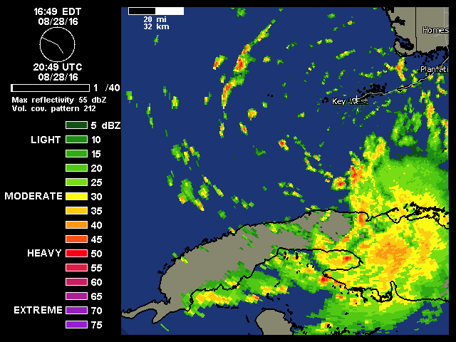
This was the center earlier. Note TD 8 too.
https://scontent-ord1-1.xx.fbcdn.net/t3 ... 8778_o.jpg
https://scontent-ord1-1.xx.fbcdn.net/t3 ... 8778_o.jpg
1 likes
The posts or stuff said are NOT an official forecast. Please look to the NHC and NWS for official forecasts and products.
Floyd-1999, Frances-2004, Jeanne-2004, Fay-2008, Beryl-2012, Debby-2012, Colin-2016, Hermine-2016, Julia-2016, Matthew-2016, Irma-2017, Elsa-2021, Idalia-2023, Debby-2024, Helene-2024.
Go Gators! Go Jags!
Floyd-1999, Frances-2004, Jeanne-2004, Fay-2008, Beryl-2012, Debby-2012, Colin-2016, Hermine-2016, Julia-2016, Matthew-2016, Irma-2017, Elsa-2021, Idalia-2023, Debby-2024, Helene-2024.
Go Gators! Go Jags!
-
Dean4Storms
- S2K Supporter
- Posts: 6358
- Age: 63
- Joined: Sun Aug 31, 2003 1:01 pm
- Location: Miramar Bch. FL
Re: ATL: NINE - Tropical Depression - Discussion
The 18Z GFS has it moving WNW from about where it is now for a time before another bend back to the west. If this continues over night you would think it would play a role in the track down the road, whether it misses the break in the ridge and sits or gets turned back east further south would be the question.
1 likes
Re: ATL: NINE - Tropical Depression - Discussion
I bet the 0z Euro will come back in stronger, 12z Euro did not made sense that it showed it to be so weak through Wednesday morning with such good UL winds it forecasts it to be, as so does the GFS.
1 likes
Who is online
Users browsing this forum: No registered users and 108 guests