ATL: MATTHEW - Models
Moderator: S2k Moderators

Re: ATL: MATTHEW - Models
Matthew just rakes the SC/NC coasts with this run. I would think strong tropical force winds with that proximity to the coast'
0 likes
-
FLpanhandle91

- Category 5

- Posts: 1039
- Age: 34
- Joined: Mon Sep 13, 2010 3:50 pm
- Location: Fort Walton Beach, FL
Re: ATL: MATTHEW - Models
Cat 5 just skirting the OBX. Beach erosion and surge could be devastating.
0 likes
-
tolakram
- Admin

- Posts: 20185
- Age: 62
- Joined: Sun Aug 27, 2006 8:23 pm
- Location: Florence, KY (name is Mark)
Re: ATL: MATTHEW - Models

0 likes
M a r k
- - - - -
Join us in chat: Storm2K Chatroom Invite. Android and IOS apps also available.
The posts in this forum are NOT official forecasts and should not be used as such. Posts are NOT endorsed by any professional institution or STORM2K.org. For official information and forecasts, please refer to NHC and NWS products.
-
tarheelprogrammer

- S2K Supporter

- Posts: 1793
- Joined: Mon Mar 28, 2016 9:25 pm
- Location: Raleigh, NC area (Garner, NC)
Re: ATL: MATTHEW - Models
18z GFS looks to have trended east and slower.
0 likes
My posts are not official forecasts. They are just my opinion and may or may not be backed by sound meteorological data. They are NOT endorsed by any professional institution or storm2k.org. For official information, please refer to the NHC and NWS products.

Re: ATL: MATTHEW - Models
Still some uncertainty 5-6 days out. We said that yesterday. It's like groundhog day around here. 
0 likes
-
sphelps8681
- Category 2

- Posts: 785
- Joined: Thu Aug 16, 2007 5:37 pm
- Location: Somewhere over the rainbow
Re: ATL: MATTHEW - Models
sphelps8681 wrote:JPmia wrote:Digital-TC-Chaser wrote:
Is the Australian Model? Thanks for introducing this to us.. is it any good? Tell us about its accuracy.
This looks right over Florida!!!

0 likes
-
CrazyC83
- Professional-Met

- Posts: 34315
- Joined: Tue Mar 07, 2006 11:57 pm
- Location: Deep South, for the first time!
Re: ATL: MATTHEW - Models
18Z GFS makes landfall around Buzzards Bay then near Boston as it starts to get caught in the upper troughs.
0 likes

Re: ATL: MATTHEW - Models
sphelps8681 wrote:sphelps8681 wrote:JPmia wrote:
Is the Australian Model? Thanks for introducing this to us.. is it any good? Tell us about its accuracy.
This looks right over Florida!!!
Ok that is good for entertainment purposes only. Not going to take it at full value.
0 likes

Re: ATL: MATTHEW - Models
Blinhart wrote:Digital-TC-Chaser wrote:JPmia wrote:
Is the Australian Model? Thanks for introducing this to us.. is it any good? Tell us about its accuracy.
The Australian Community Climate and Earth-System Simulator (ACCESS) weather models have been developed and tested by research staff from the Bureau's Research & Development Branch and are based on the UK Meteorological Office's Unified Model. ACCESS output is available in map form or as gridded data products.
The model is a hybrid and often out performs the other global models.
hope this isn't true, this could turn out bad for a lot of people.
There's a reason most of us have never seen this model before.
1 likes
Personal Forecast Disclaimer:
My posts are just my opinion and are most likely not backed by sound meteorological data. They are NOT endorsed by any professional institution or storm2k.org. For official information, please refer to the NHC and NWS products.
Bottom line is that I am just expressing my opinion!!!
My posts are just my opinion and are most likely not backed by sound meteorological data. They are NOT endorsed by any professional institution or storm2k.org. For official information, please refer to the NHC and NWS products.
Bottom line is that I am just expressing my opinion!!!
-
p1nheadlarry

- Category 2
- Posts: 672
- Age: 34
- Joined: Wed Jan 29, 2014 2:42 pm
- Location: SR County FL
Re: ATL: MATTHEW - Models
FLpanhandle91 wrote:Cat 5 just skirting the OBX. Beach erosion and surge could be devastating.
Just trying to think about what the GFS sees to support a hurricane that strong north of 30 degrees.
0 likes
--;->#GoNoles--;->.
-
CrazyC83
- Professional-Met
- Posts: 34315
- Joined: Tue Mar 07, 2006 11:57 pm
- Location: Deep South, for the first time!
Re: ATL: MATTHEW - Models
p1nheadlarry wrote:FLpanhandle91 wrote:Cat 5 just skirting the OBX. Beach erosion and surge could be devastating.
Just trying to think about what the GFS sees to support a hurricane that strong north of 30 degrees.
Maybe the size of the storm enlarges greatly or it gets caught in an area with no real shear interactions? The lowest pressure I know of in that region is 930mb.
0 likes
-
TheStormExpert
Re: ATL: MATTHEW - Models
According to the most recent GFS runs it seems the threat to Florida is decreasing.
0 likes
-
FLpanhandle91
- Category 5
- Posts: 1039
- Age: 34
- Joined: Mon Sep 13, 2010 3:50 pm
- Location: Fort Walton Beach, FL
Re: ATL: MATTHEW - Models
p1nheadlarry wrote:FLpanhandle91 wrote:Cat 5 just skirting the OBX. Beach erosion and surge could be devastating.
Just trying to think about what the GFS sees to support a hurricane that strong north of 30 degrees.
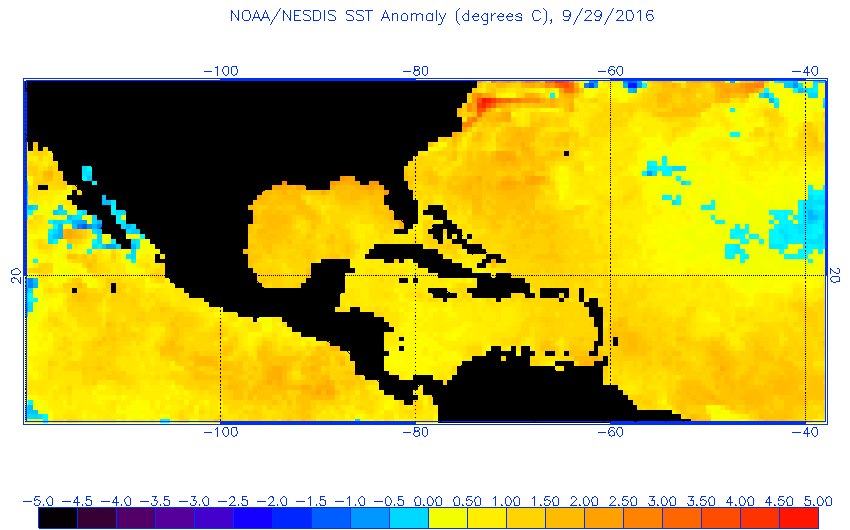
I believe SST's around that area are very warm this year.
1 likes

Re: ATL: MATTHEW - Models
TheStormExpert wrote:According to the most recent GFS runs it seems the threat to Florida is decreasing.
Maybe South Florida but it still looks to close enough for North-Central Florida for my liking.
0 likes
The posts or stuff said are NOT an official forecast. Please look to the NHC and NWS for official forecasts and products.
Floyd-1999, Frances-2004, Jeanne-2004, Fay-2008, Beryl-2012, Debby-2012, Colin-2016, Hermine-2016, Julia-2016, Matthew-2016, Irma-2017, Elsa-2021, Idalia-2023, Debby-2024, Helene-2024.
Go Gators! Go Jags!
Floyd-1999, Frances-2004, Jeanne-2004, Fay-2008, Beryl-2012, Debby-2012, Colin-2016, Hermine-2016, Julia-2016, Matthew-2016, Irma-2017, Elsa-2021, Idalia-2023, Debby-2024, Helene-2024.
Go Gators! Go Jags!
-
p1nheadlarry
- Category 2
- Posts: 672
- Age: 34
- Joined: Wed Jan 29, 2014 2:42 pm
- Location: SR County FL
Re: ATL: MATTHEW - Models
FLpanhandle91 wrote:p1nheadlarry wrote:FLpanhandle91 wrote:Cat 5 just skirting the OBX. Beach erosion and surge could be devastating.
Just trying to think about what the GFS sees to support a hurricane that strong north of 30 degrees.
I believe SST's around that area are very warm this year.
They are indeed, but outside of the Gulf Stream they're not terribly deep. How it leaves the Bahamas as a strong cyclone and strengthens even more with slightly cooler waters and lower TCHP values isn't adding up to me.
0 likes
--;->#GoNoles--;->.
-
centuryv58

- Tropical Storm

- Posts: 233
- Age: 67
- Joined: Sat Jul 30, 2016 1:24 pm
- Location: Southeast Florida
Re: ATL: MATTHEW - Models
JaxGator wrote:TheStormExpert wrote:According to the most recent GFS runs it seems the threat to Florida is decreasing.
Maybe South Florida but it still looks to close enough for North-Central Florida for my liking.
Still too close and uncertain for me in SE FL. I'll have more confidence after tomorrow.
2 likes
-
SFLcane

- S2K Supporter
- Posts: 10281
- Age: 48
- Joined: Sat Jun 05, 2010 1:44 pm
- Location: Lake Worth Florida
Re: ATL: MATTHEW - Models
To many focus on landfall affects should be felt even in south Florida as Matthew passes to our east. How close is the question
0 likes
Re: ATL: MATTHEW - Models
If the GFS Verifies, that's very good for Jamaica, they'll miss the worst of it, not so good for Haiti Cuba and the Bahamas though. Taking more than a week to reach the Outer Banks would make a lot of folks nervous.
0 likes
-
Rail Dawg
- S2K Supporter
- Posts: 326
- Joined: Mon Aug 27, 2012 5:02 pm
- Location: Where the eye makes landfall.
Re: ATL: MATTHEW - Models
I feel like I'm back in the 80's sometimes relying on grainy black and white satellite shots and ship reports.
This thing has been forecasted for more than 2 days to turn by now.
If in the am it is sitting still or making it's way west then the models... almost all of them.. were wrong.
Sometimes it's good to go back to the old ways of gut feelings and experience.
This thing has been forecasted for more than 2 days to turn by now.
If in the am it is sitting still or making it's way west then the models... almost all of them.. were wrong.
Sometimes it's good to go back to the old ways of gut feelings and experience.
2 likes
Although I have been a hurricane forecaster since 1980 that only means I've been wrong lots of times.
-
sphelps8681
- Category 2
- Posts: 785
- Joined: Thu Aug 16, 2007 5:37 pm
- Location: Somewhere over the rainbow
Re: ATL: MATTHEW - Models
MetroMike wrote:sphelps8681 wrote:sphelps8681 wrote:
This looks right over Florida!!!
Ok that is good for entertainment purposes only. Not going to take it at full value.
I am just trying to understand. The Euro and GFS have both forcasted a turn to the North. But from what I see that has not happened yet. So all of them forecast something going east of Florida and possibly up the coast to the Carolinas what makes this one only for entertainment purposes? Looks like they are all entertainment purposes at this time.
2 likes
Who is online
Users browsing this forum: No registered users and 21 guests