
ConvergenceZone wrote:Don't models suppose to run every 6 hours? For some reason we'd have one more EURO run before the one late tonight?
Big globals such as CMC, UKMET, and EURO are run twice a day at 00z and 12z GMT.
Moderator: S2k Moderators
ConvergenceZone wrote:Don't models suppose to run every 6 hours? For some reason we'd have one more EURO run before the one late tonight?
wxman57 wrote:miamijaaz wrote:NAVGEM is at least persistent, you gotta give it that.
Yes, it is persistently the worst model in the world for tropical cyclones.
On another note, I see that the EC ensembles are nothing at all like the operational run. They're very much like the 18Z GFS.
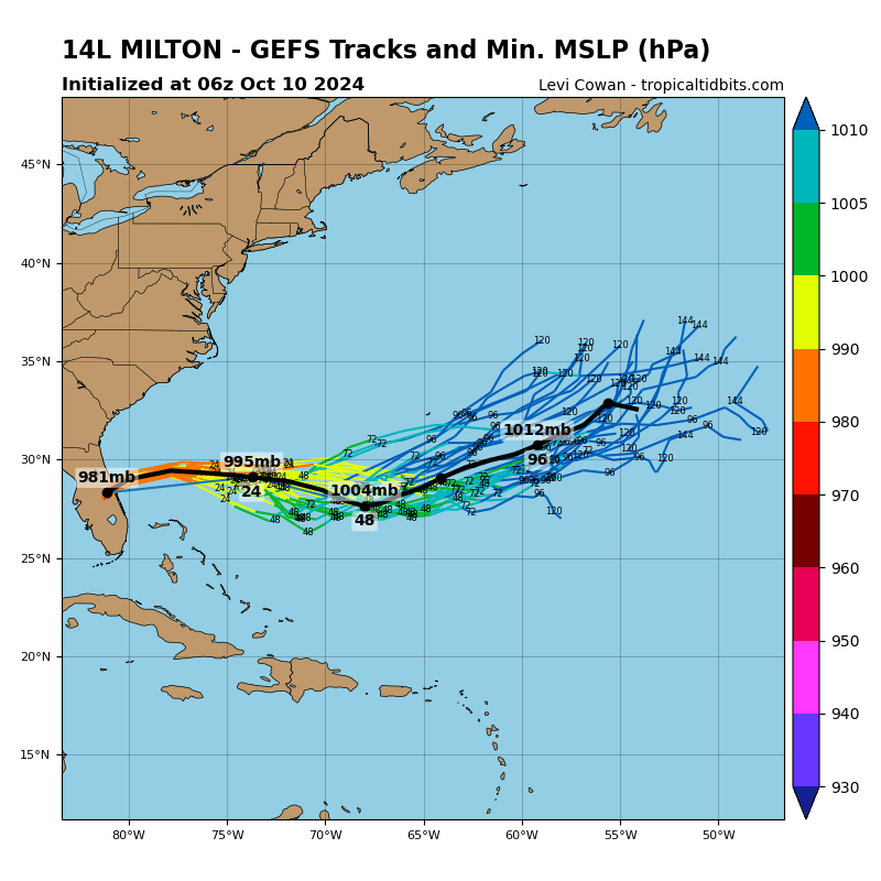
WHYB630 wrote:more GEFS ensemble members show the lopping movement in 18z run
Seems like EC is not -removed-
http://www.tropicaltidbits.com/storminf ... latest.png


Ken711 wrote:wxman57 wrote:miamijaaz wrote:NAVGEM is at least persistent, you gotta give it that.
Yes, it is persistently the worst model in the world for tropical cyclones.
On another note, I see that the EC ensembles are nothing at all like the operational run. They're very much like the 18Z GFS.
Is this a good or bad thing for the Carolinas and specifically the OBX?
tolakram wrote:For those needing to catch up click the link in my signature to see an experimental tracking page with graphics of the last few GFS and ECMWF runs plus links to Tropical Tidbits where you can peruse all the recent runs.

TJRE wrote:WHYB630 wrote:more GEFS ensemble members show the lopping movement in 18z run
Seems like EC is not -removed-
http://www.tropicaltidbits.com/storminf ... latest.png
some non- pros think the Euro has a Fujiwhara dance with Nicole that's why the loop de loop
[img]http://www.tropicaltidbits.com/analysis/models/ecmwf/2016100412/ecmwf_z500_mslp_watl_7.png
GO FIGURE
https://en.wikipedia.org/wiki/Fujiwhara_effect
sample image
[img]https://upload.wikimedia.org/wikipedia/commons/thumb/c/cc/ParmaMelor_AMO_TMO_2009279_lrg.jpg/220px-ParmaMelor_AMO_TMO_2009279_lrg.jpg
THE GLOBAL
MODELS SHOW THE RIDGE TO THE NORTH OF JEANNE ERODING OVER THE NEXT
3 DAYS AS THE STRONG MID-LEVEL REMANT OF IVAN DROPS SOUTHWARD.
THIS RESULTS IN JEANNE MOVING NORTH-NORTHWESTWARD AT LESS THAN 10
KT. AN INTERACTION BETWEEN JEANNE AND IVAN IS SUGGESTED BY DAY 3
AS THE CENTERS OF THE TWO SYSTEMS COME WITHIN ABOUT 700 N MI OF
EACH OTHER.
boulderrr wrote:00Z shows an eastward shift up toward the Carolinas and beyond:
http://www.tropicaltidbits.com/storminf ... ks_00z.png

HurrMark wrote:Interesting that the HWRF has shifted quite a bit east. It went from a SC landfall to a NC landfall to no landfall. Of course, it's probably not the best model to use...
I do think, though, that the NHC will probably take New England out of the picture in the next advisory. I don't see anything in the ops and ensembles that would indicate a threat at this time.
Aric Dunn wrote:HurrMark wrote:Interesting that the HWRF has shifted quite a bit east. It went from a SC landfall to a NC landfall to no landfall. Of course, it's probably not the best model to use...
I do think, though, that the NHC will probably take New England out of the picture in the next advisory. I don't see anything in the ops and ensembles that would indicate a threat at this time.
it shifted west for the first 72 hours.. the latter part is to far out given the setup
HurrMark wrote:boulderrr wrote:00Z shows an eastward shift up toward the Carolinas and beyond:
http://www.tropicaltidbits.com/storminf ... ks_00z.png
These models are useless at this time...they are only helpful in the tropics. The only one worth looking at is TVCN and maybe the UK ones.
HurrMark wrote:Aric Dunn wrote:HurrMark wrote:Interesting that the HWRF has shifted quite a bit east. It went from a SC landfall to a NC landfall to no landfall. Of course, it's probably not the best model to use...
I do think, though, that the NHC will probably take New England out of the picture in the next advisory. I don't see anything in the ops and ensembles that would indicate a threat at this time.
it shifted west for the first 72 hours.. the latter part is to far out given the setup
True...still a good 100 miles from Florida, though.
Ken711 wrote:
Which color on the chart is the TVCN track?
Aric Dunn wrote:east outlier that shifted quite a bit west..says more than you think.


Aric Dunn wrote:HurrMark wrote:Aric Dunn wrote:
it shifted west for the first 72 hours.. the latter part is to far out given the setup
True...still a good 100 miles from Florida, though.
east outlier that shifted quite a bit west..says more than you think.
HurrMark wrote:Ken711 wrote:
Which color on the chart is the TVCN track?
Gray. To be honest, I can't see it at all south of the Carolinas...everything is too clustered.

Ken711 wrote:HurrMark wrote:boulderrr wrote:00Z shows an eastward shift up toward the Carolinas and beyond:
These models are useless at this time...they are only helpful in the tropics. The only one worth looking at is TVCN and maybe the UK ones.
Which color on the chart is the TVCN track?

Users browsing this forum: No registered users and 33 guests


