
CPAC: DARBY - Post-Tropical
Moderator: S2k Moderators
-
Kingarabian

- S2K Supporter

- Posts: 16348
- Joined: Sat Aug 08, 2009 3:06 am
- Location: Honolulu, Hawaii
 Another doughnut is on the way yum.
-
Kingarabian
- S2K Supporter
- Posts: 16348
- Joined: Sat Aug 08, 2009 3:06 am
- Location: Honolulu, Hawaii
Re: EPAC: DARBY - Hurricane
000
WTPZ45 KNHC 140853
TCDEP5
HURRICANE DARBY DISCUSSION NUMBER 11
NWS NATIONAL HURRICANE CENTER MIAMI FL EP052016
200 AM PDT THU JUL 14 2016
Darby continues to generate a large area of cold cloud tops near
the center, and recent microwave images show a mid-level eye is
present. However, the images also suggest this feature is displaced
to the south or southwest of the low-level center, possibly due to
the effects of northeasterly vertical wind shear. Satellite
intensity estimates from TAFB and SAB remain unchanged at 65 kt, and
earlier AMSU intensity estimates were near 70 kt. So, the initial
intensity remains 70 kt.
The initial motion is 275/10. The dynamical models forecast a
large deep-layer ridge over much of the eastern and central Pacific
for the next several days, and this feature should steer Darby
generally westward through the forecast period. The track guidance
has similar tracks to that of the previous advisory, but it shows
a slightly faster forward speed. Thus, the new forecast track,
which is a blend of the GFS and ECMWF forecasts, is similar to, but
a little faster than, the previous track.
The current shear should subside in the next 12 hours or so, with
Darby likely to remain in a light shear environment during the
remainder of the forecast period. Therefore, sea surface
temperature is expected to be the major factor controlling Darby's
intensity. The hurricane is currently over sea surface temperatures
near 27C, and this should continue for the next 36 hours or so.
During this time, the intensity forecast calls for slow
strengthening. From 48-72 hours, the forecast track takes Darby
across an area of sea surface temperatures less than 25C, a cold
pool that is poorly resolved in the statistical guidance. The
intensity forecast calls for significant weakening from 48-72 hours,
with the 72 hour forecast on the low side of the intensity guidance.
After 72 hours, Darby should move over increasing sea surface
temperatures near or parallel to the 26C isotherm. At that time,
though, the cyclone is expected to encounter a drier and more stable
air mass, so the forecast follows the guidance in calling for a
continued slow weakening.
FORECAST POSITIONS AND MAX WINDS
INIT 14/0900Z 15.7N 115.5W 70 KT 80 MPH
12H 14/1800Z 16.0N 117.5W 75 KT 85 MPH
24H 15/0600Z 16.4N 119.9W 80 KT 90 MPH
36H 15/1800Z 16.8N 122.2W 85 KT 100 MPH
48H 16/0600Z 17.1N 124.2W 85 KT 100 MPH
72H 17/0600Z 17.5N 128.0W 65 KT 75 MPH
96H 18/0600Z 18.0N 131.5W 55 KT 65 MPH
120H 19/0600Z 18.5N 136.0W 45 KT 50 MPH
$$
Forecaster Beven
0 likes
RIP Kobe Bryant
-
stormwise
Re: EPAC: DARBY - Hurricane
GFS is very aggressive with this system.
http://mkwc2.ifa.hawaii.edu/models/mode ... type=flash
http://mkwc2.ifa.hawaii.edu/models/mode ... type=flash
0 likes
-
Yellow Evan

- Professional-Met

- Posts: 16231
- Age: 27
- Joined: Fri Jul 15, 2011 12:48 pm
- Location: Henderson, Nevada/Honolulu, HI
- Contact:
Re: EPAC: DARBY - Hurricane
Mid-level shear has abruptly increased. Darby looks terrible right now.
0 likes

Re: EPAC: DARBY - Hurricane
Clearly the mid level circulation is displaced from the low level circulation.
0 likes
Re: EPAC: DARBY - Hurricane
Kingarabian wrote:http://i.imgur.com/E9Uo1ja.jpg
Great image but it also shows how slanted the system is.
1 likes
-
Kingarabian
- S2K Supporter
- Posts: 16348
- Joined: Sat Aug 08, 2009 3:06 am
- Location: Honolulu, Hawaii
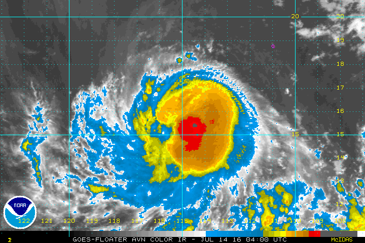
Re: EPAC: DARBY - Hurricane
Despite its ragged satellite appearance, it's maintaining intensity:

0 likes
RIP Kobe Bryant
Re: EPAC: DARBY - Hurricane
Still has an eye like feature but most of the deep convection is to the south of it.

0 likes
-
Kingarabian
- S2K Supporter
- Posts: 16348
- Joined: Sat Aug 08, 2009 3:06 am
- Location: Honolulu, Hawaii
Re: EPAC: DARBY - Hurricane
NDG wrote:Still has an eye like feature but most of the deep convection is to the south of it.
[img]http://www.nrlmry.navy.mil/tcdat/tc16/EPAC/05E.DARBY/amsr2/composite/20160714.0914.gcomw1.x.composite.05EDARBY.70kts-989mb-156N-1150W.78pc.jpg[img]
Yeah taking a look at the lower levels, it's certainly not coupled:

0 likes
RIP Kobe Bryant
Re: EPAC: DARBY - Hurricane
Kingarabian wrote:NDG wrote:Still has an eye like feature but most of the deep convection is to the south of it.
[img]http://www.nrlmry.navy.mil/tcdat/tc16/EPAC/05E.DARBY/amsr2/composite/20160714.0914.gcomw1.x.composite.05EDARBY.70kts-989mb-156N-1150W.78pc.jpg[img]
Yeah taking a look at the lower levels, it's certainly not coupled:
http://i.imgur.com/BTNlxhn.jpg
Yeah, the MLC is a good 40 miles SW of the low level circulation if not a little more.
0 likes
-
cycloneye

- Admin

- Posts: 149275
- Age: 69
- Joined: Thu Oct 10, 2002 10:54 am
- Location: San Juan, Puerto Rico
Re: EPAC: DARBY - Hurricane
HURRICANE DARBY DISCUSSION NUMBER 12
NWS NATIONAL HURRICANE CENTER MIAMI FL EP052016
800 AM PDT THU JUL 14 2016
Darby still appears to be feeling the effects of 10-15 kt of
northeasterly shear. Recent microwave images continue to show a
mid-level eye, but the deep convection has an asymmetric structure,
primarily focused to the south and southwest of the center.
Subjective and objective Dvorak estimates have not changed during
the past six hours, and the initial intensity is therefore held at
70 kt. Although Darby is moving over a relative cool spot in the
ocean, SSTs are still plenty warm to support strengthening for the
next 36 hours. A limiting factor may be continued vertical shear,
which does not seem to have decreased as the models had been
indicating. The SHIPS guidance now shows the shear staying up
between 10-15 kt during the next 24 hours, so only a little more
strengthening is shown in the official forecast. The new NHC
forecast shows a slightly lower peak intensity, and it should be
noted that this forecast is still near the high end of the
guidance. Much colder SSTs, on the order of 24-25 degrees Celsius,
should contribute to weakening beyond 48 hours.
The initial motion remains westward, or 280/11 kt. A well-
established ridge to the north of Darby should continue steering
the cyclone westward during the next five days. With the exception
of the GFDL and HWRF models, which are located along the northern
edge of the guidance envelope, the track models are tightly
clustered and are showing more agreement than yesterday. The NHC
forecast is south of the TVCE model consensus, and is very close to
the previous official forecast and an average of the GFS and ECMWF
models.
FORECAST POSITIONS AND MAX WINDS
INIT 14/1500Z 15.9N 116.9W 70 KT 80 MPH
12H 15/0000Z 16.3N 118.7W 75 KT 85 MPH
24H 15/1200Z 16.7N 121.1W 80 KT 90 MPH
36H 16/0000Z 17.0N 123.2W 80 KT 90 MPH
48H 16/1200Z 17.2N 125.2W 80 KT 90 MPH
72H 17/1200Z 17.4N 128.7W 65 KT 75 MPH
96H 18/1200Z 17.8N 132.5W 55 KT 65 MPH
120H 19/1200Z 18.5N 137.0W 45 KT 50 MPH
$$
Forecaster Berg
0 likes
Visit the Caribbean-Central America Weather Thread where you can find at first post web cams,radars
and observations from Caribbean basin members Click Here
and observations from Caribbean basin members Click Here
-
Kingarabian
- S2K Supporter
- Posts: 16348
- Joined: Sat Aug 08, 2009 3:06 am
- Location: Honolulu, Hawaii
Re: EPAC: DARBY - Hurricane
Still tilted but getting better.


Also doesn't look to be wrapping around dry air anymore.
Also doesn't look to be wrapping around dry air anymore.
0 likes
RIP Kobe Bryant
-
TropicalAnalystwx13

- Category 5

- Posts: 2109
- Age: 28
- Joined: Tue Jul 19, 2011 8:20 pm
- Location: Wilmington, NC
- Contact:

-
TropicalAnalystwx13
- Category 5
- Posts: 2109
- Age: 28
- Joined: Tue Jul 19, 2011 8:20 pm
- Location: Wilmington, NC
- Contact:


Re: EPAC: DARBY - Hurricane
Looks better and also on microwave.
0 likes
The posts or stuff said are NOT an official forecast. Please look to the NHC and NWS for official forecasts and products.
Floyd-1999, Frances-2004, Jeanne-2004, Fay-2008, Beryl-2012, Debby-2012, Colin-2016, Hermine-2016, Julia-2016, Matthew-2016, Irma-2017, Elsa-2021, Idalia-2023, Debby-2024, Helene-2024.
Go Gators! Go Jags!
Floyd-1999, Frances-2004, Jeanne-2004, Fay-2008, Beryl-2012, Debby-2012, Colin-2016, Hermine-2016, Julia-2016, Matthew-2016, Irma-2017, Elsa-2021, Idalia-2023, Debby-2024, Helene-2024.
Go Gators! Go Jags!
-
Yellow Evan
- Professional-Met
- Posts: 16231
- Age: 27
- Joined: Fri Jul 15, 2011 12:48 pm
- Location: Henderson, Nevada/Honolulu, HI
- Contact:
Re: EPAC: DARBY - Hurricane
Code: Select all
EP, 05, 201607141800, 10, DVTS, CI, , 1550N, 11760W, , 1, 77, 2, , , , , , , , , , , , , , , , , E, SAB, JM, VIM, 1, 4545 /////, , , GOES15, LLCC, T, DT=4.5 BO EYE MET=4.5 PT=4.5 FTBO DT
0 likes
-
Yellow Evan
- Professional-Met
- Posts: 16231
- Age: 27
- Joined: Fri Jul 15, 2011 12:48 pm
- Location: Henderson, Nevada/Honolulu, HI
- Contact:
Re: EPAC: DARBY - Hurricane
Code: Select all
EP, 05, 2016071418, , BEST, 0, 158N, 1175W, 75, 985, HU, 64, NEQ, 25, 20, 20, 25, 1011, 220, 20, 0, 0, E, 0, , 0, 0, DARBY, D, 0, , 0, 0, 0, 0, genesis-num, 011, Either the NHC is being conservative for no real reason or TAFB somehow thought this was a T4.0.
0 likes
-
cycloneye
- Admin
- Posts: 149275
- Age: 69
- Joined: Thu Oct 10, 2002 10:54 am
- Location: San Juan, Puerto Rico
Re: EPAC: DARBY - Hurricane
0 likes
Visit the Caribbean-Central America Weather Thread where you can find at first post web cams,radars
and observations from Caribbean basin members Click Here
and observations from Caribbean basin members Click Here
Who is online
Users browsing this forum: No registered users and 94 guests