ATL: FRANKLIN - Remnants - Discussion

Moderator: S2k Moderators

Message
Author
Thetxhurricanemaster
Category 1
Category 1
Posts: 279
Age: 33
Joined: Tue Aug 01, 2017 6:53 pm
Location: Corpus christi

Re: ATL: INVEST 90L - Models

#121 Postby Thetxhurricanemaster » Fri Aug 04, 2017 3:52 pm

gatorcane wrote:Not really a surprise the Euro is showing this heading into BOC-Mexico. That has been a pretty typical path for BOC storms going back the last 7 seasons. Still not certain that will be the outcome or whether this develops (though it is looking better than 99L for development).

I have a question..... What do theverything 12Z Euro Esembles show ???? For 90L
0 likes   

User avatar
Hypercane_Kyle
Category 5
Category 5
Posts: 2902
Joined: Sat Mar 07, 2015 7:58 pm
Location: Cape Canaveral, FL

Re: ATL: INVEST 90L - Models

#122 Postby Hypercane_Kyle » Fri Aug 04, 2017 4:10 pm

South Texas Storms wrote:I'm not convinced the Euro is initializing the system well. It shows it developing from a naked swirl just off the coast of South America. I think it will be closer to the convection currently tracking across the Caribbean. Confidence in its track still remains low.


100% agreement from me (.gif attached below to illustrate what you're talking about). The run makes no sense, IMO:

Image
1 likes   
My posts are my own personal opinion, defer to the National Hurricane Center (NHC) and other NOAA products for decision making during hurricane season.

User avatar
Hammy
Category 5
Category 5
Posts: 5594
Age: 40
Joined: Fri May 25, 2012 5:25 pm
Contact:

Re: ATL: INVEST 90L - Models

#123 Postby Hammy » Fri Aug 04, 2017 4:57 pm

GFS trending towards having the low in the Pacific rather than Gulf.
0 likes   
The above post is not official and should not be used as such. It is the opinion of the poster and may or may not be backed by sound meteorological data. It is not endorsed by any professional institution or storm2k.org. For official information, please refer to the NHC and NWS products.

Alyono
Professional-Met
Professional-Met
Posts: 6961
Joined: Fri Apr 26, 2013 3:52 pm
Location: Texas Coast

Re: ATL: INVEST 90L - Models

#124 Postby Alyono » Fri Aug 04, 2017 5:04 pm

Hammy wrote:GFS trending towards having the low in the Pacific rather than Gulf.


trending stronger in the BOC again this run
0 likes   

stormreader
Category 5
Category 5
Posts: 1242
Joined: Fri Jun 24, 2011 10:58 am

Re: ATL: INVEST 90L - Discussion

#125 Postby stormreader » Fri Aug 04, 2017 5:39 pm

Heavy T-storms overland and in Venezuelan coastal waters seem to be migrating offshore and over that small swirl that we have seen.
Image
0 likes   

stormreader
Category 5
Category 5
Posts: 1242
Joined: Fri Jun 24, 2011 10:58 am

Re: ATL: INVEST 90L - Models

#126 Postby stormreader » Fri Aug 04, 2017 5:44 pm

South Texas Storms wrote:I'm not convinced the Euro is initializing the system well. It shows it developing from a naked swirl just off the coast of South America. I think it will be closer to the convection currently tracking across the Caribbean. Confidence in its track still remains low.

You may be right, but just looked at sat pic and it seems as though that swirl in coastal waters is being covered now with heavy t-storms.
0 likes   

User avatar
tropicwatch
Category 5
Category 5
Posts: 3205
Age: 60
Joined: Sat Jun 02, 2007 10:01 am
Location: Panama City Florida
Contact:

Re: ATL: INVEST 90L - Discussion

#127 Postby tropicwatch » Fri Aug 04, 2017 5:48 pm

:uarrow: Been watching that area the past couple of hours. Have to wait and see if the convection continues to build with the rotation offshore.
1 likes   
Tropicwatch


Agnes 72', Eloise 75, Elena 85', Kate 85', Charley 86', Florence 88', Beryl 94', Dean 95', Erin 95', Opal 95', Earl 98', Georges 98', Ivan 2004', Arlene 2005', Dennis 2005', Ida 2009' Debby 2012' Irma 2017' Michael 2018'

User avatar
Nimbus
Category 5
Category 5
Posts: 4933
Joined: Mon Jul 19, 2004 10:54 am

Re: ATL: INVEST 90L - Discussion

#128 Postby Nimbus » Fri Aug 04, 2017 6:00 pm

There is a TUTT up near the islands that will likely enhance the convection.
TUTT appears to be lifting out so maybe not enough there to shear 90L soon.
0 likes   

User avatar
tropicwatch
Category 5
Category 5
Posts: 3205
Age: 60
Joined: Sat Jun 02, 2007 10:01 am
Location: Panama City Florida
Contact:

Re: ATL: INVEST 90L - Discussion

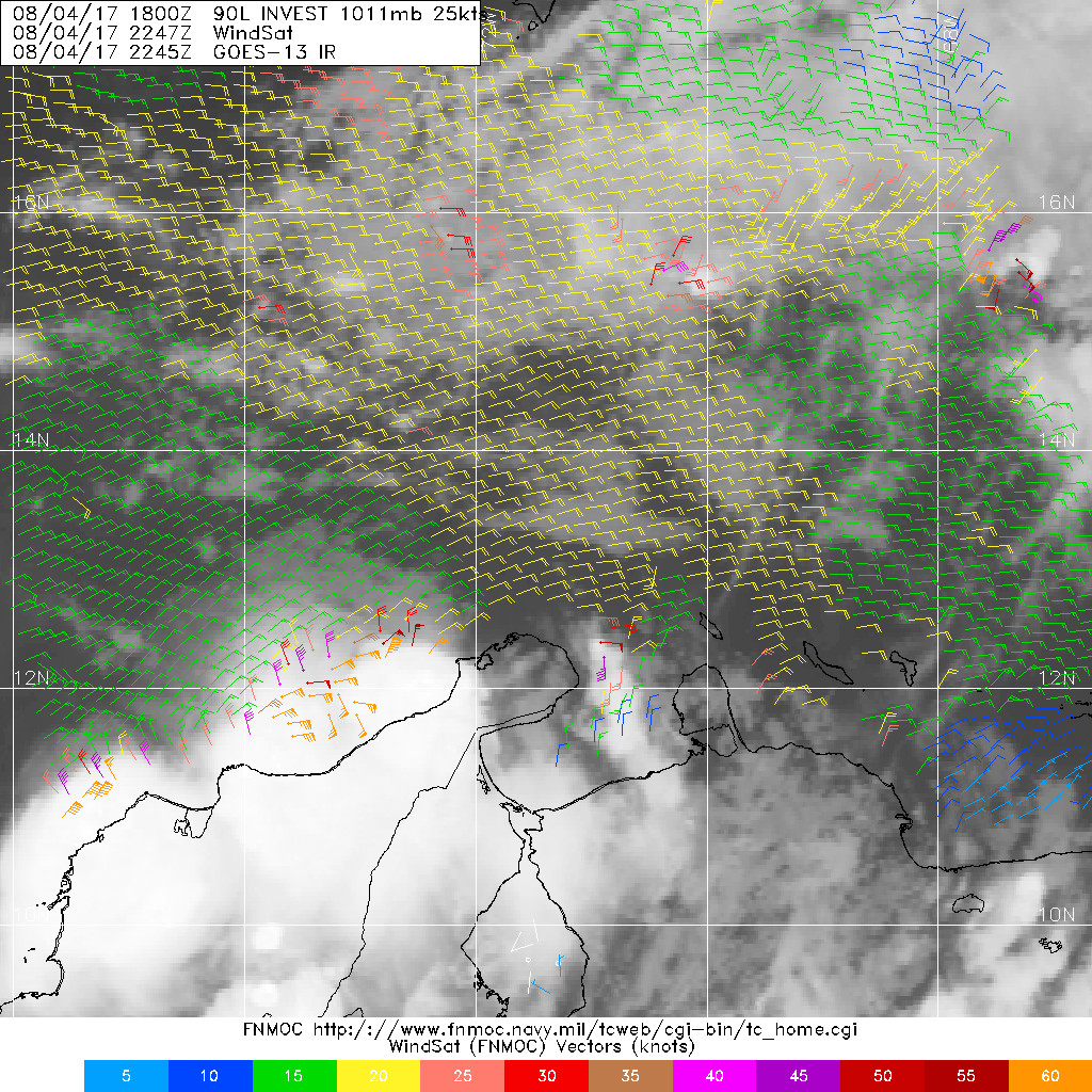
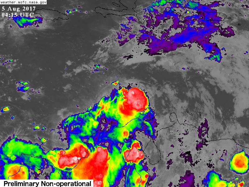
#129 Postby tropicwatch » Fri Aug 04, 2017 6:32 pm

A tropical wave is producing disorganized showers and thunderstorms
over the central Caribbean Sea. Development is expected to be slow
during the next day or two as the disturbance moves west-
northwestward at about 15 mph across the western Caribbean. By the
end of the weekend or early next week, environmental conditions
appear more conducive for development when the system moves near or
over the Yucatan Peninsula and the Bay of Campeche.
* Formation chance through 48 hours...low...20 percent.
* Formation chance through 5 days...medium...60 percent.
0 likes   
Tropicwatch


Agnes 72', Eloise 75, Elena 85', Kate 85', Charley 86', Florence 88', Beryl 94', Dean 95', Erin 95', Opal 95', Earl 98', Georges 98', Ivan 2004', Arlene 2005', Dennis 2005', Ida 2009' Debby 2012' Irma 2017' Michael 2018'

stormreader
Category 5
Category 5
Posts: 1242
Joined: Fri Jun 24, 2011 10:58 am

ATL: INVEST 90L - Models

#130 Postby stormreader » Fri Aug 04, 2017 7:11 pm

Pic shows growing T-storm activity just along Venezuelan coast (near that small swirl that persisted for a day or two). This is very near where the latest Euro runs (I've been told) initialize a tropical cyclone. Perhaps a center will form further north (seen that happen before). But the growing t-storm activity near Euro initialization could be the real deal.
Image
0 likes   

User avatar
GCANE
S2K Supporter
S2K Supporter
Posts: 10787
Joined: Mon Oct 22, 2007 8:03 am

Re: ATL: INVEST 90L - Discussion

#131 Postby GCANE » Fri Aug 04, 2017 7:40 pm

Looks like shear will likely wipe this out over the weekend.
0 likes   

Thetxhurricanemaster
Category 1
Category 1
Posts: 279
Age: 33
Joined: Tue Aug 01, 2017 6:53 pm
Location: Corpus christi

Re: ATL: INVEST 90L - Discussion

#132 Postby Thetxhurricanemaster » Fri Aug 04, 2017 7:44 pm

GCANE wrote:Looks like shear will likely wipe this out over the weekend.


Dude what shear??? CONDITIONS ARE GONNA BE FAVORABLE FOR DEVELOPEMENT STARTING MONDAY
1 likes   

Alyono
Professional-Met
Professional-Met
Posts: 6961
Joined: Fri Apr 26, 2013 3:52 pm
Location: Texas Coast

Re: ATL: INVEST 90L - Discussion

#133 Postby Alyono » Fri Aug 04, 2017 7:46 pm

GCANE wrote:Looks like shear will likely wipe this out over the weekend.


huh?
1 likes   

User avatar
Emmett_Brown
Category 5
Category 5
Posts: 1344
Joined: Wed Aug 24, 2005 9:10 pm
Location: Sarasota FL

Re: ATL: INVEST 90L - Models

#134 Postby Emmett_Brown » Fri Aug 04, 2017 9:30 pm

I seem to remember Mitch starting from a big blob of convection that moved off of the SA coast in a similar manner.
1 likes   

Alyono
Professional-Met
Professional-Met
Posts: 6961
Joined: Fri Apr 26, 2013 3:52 pm
Location: Texas Coast

Re: ATL: INVEST 90L - Discussion

#135 Postby Alyono » Fri Aug 04, 2017 10:45 pm

quite a bit of new convection firing up near the broad low. Models seem to have initialized this one properly

If this makes the Gulf, a hurricane is likely
0 likes   

User avatar
tarheelprogrammer
S2K Supporter
S2K Supporter
Posts: 1793
Joined: Mon Mar 28, 2016 9:25 pm
Location: Raleigh, NC area (Garner, NC)

Re: ATL: INVEST 90L - Models

#136 Postby tarheelprogrammer » Fri Aug 04, 2017 11:06 pm

GFS tonight has 90L buried into Central America. I do not think it is showing much development if at all.
0 likes   
My posts are not official forecasts. They are just my opinion and may or may not be backed by sound meteorological data. They are NOT endorsed by any professional institution or storm2k.org. For official information, please refer to the NHC and NWS products.

User avatar
tropicwatch
Category 5
Category 5
Posts: 3205
Age: 60
Joined: Sat Jun 02, 2007 10:01 am
Location: Panama City Florida
Contact:

Re: ATL: INVEST 90L - Discussion

#137 Postby tropicwatch » Fri Aug 04, 2017 11:16 pm

Here is the Windsat from around 5:47pm central time. Unfortunately tonight's Ascat was too far east. Might just have something going finally.

Image
0 likes   
Tropicwatch


Agnes 72', Eloise 75, Elena 85', Kate 85', Charley 86', Florence 88', Beryl 94', Dean 95', Erin 95', Opal 95', Earl 98', Georges 98', Ivan 2004', Arlene 2005', Dennis 2005', Ida 2009' Debby 2012' Irma 2017' Michael 2018'

Alyono
Professional-Met
Professional-Met
Posts: 6961
Joined: Fri Apr 26, 2013 3:52 pm
Location: Texas Coast

Re: ATL: INVEST 90L - Models

#138 Postby Alyono » Fri Aug 04, 2017 11:19 pm

Canadian MUCH stronger. Has this becoming a named storm before reaching Belize
0 likes   

User avatar
Hammy
Category 5
Category 5
Posts: 5594
Age: 40
Joined: Fri May 25, 2012 5:25 pm
Contact:

Re: ATL: INVEST 90L - Discussion

#139 Postby Hammy » Fri Aug 04, 2017 11:32 pm

If the next few model runs continue the current trend I'd say the chances of this developing are about 10% at best. What organization existed a few days ago is gone and it seems the energy ended up too far south to make it into the Gulf at this point. Expecting NHC to lower the chances later.
0 likes   
The above post is not official and should not be used as such. It is the opinion of the poster and may or may not be backed by sound meteorological data. It is not endorsed by any professional institution or storm2k.org. For official information, please refer to the NHC and NWS products.

User avatar
tropicwatch
Category 5
Category 5
Posts: 3205
Age: 60
Joined: Sat Jun 02, 2007 10:01 am
Location: Panama City Florida
Contact:

Re: ATL: INVEST 90L - Discussion

#140 Postby tropicwatch » Fri Aug 04, 2017 11:41 pm

:uarrow: I wouldn't be too quick to write it off just yet.

Image
0 likes   
Tropicwatch


Agnes 72', Eloise 75, Elena 85', Kate 85', Charley 86', Florence 88', Beryl 94', Dean 95', Erin 95', Opal 95', Earl 98', Georges 98', Ivan 2004', Arlene 2005', Dennis 2005', Ida 2009' Debby 2012' Irma 2017' Michael 2018'


Return to “2017”

Who is online

Users browsing this forum: Google Adsense [Bot] and 7 guests