ATL: TEN - Post-Tropical - Discussion

Moderator: S2k Moderators

Message
Author
forecasterjack
Tropical Storm
Tropical Storm
Posts: 195
Joined: Wed Aug 23, 2017 3:44 pm

Re: ATL: INVEST 92L - Discussion

#1641 Postby forecasterjack » Sun Aug 27, 2017 11:55 am

northjaxpro wrote:This to.me has the appearance of a sub-tropical storm. It is coming together quite well early this afternoon off the GA coast.

Sure is looking good. Perhaps it has a short window of opportunity to develop into a TS or STS before going full frontal
0 likes   

Sanibel
Category 5
Category 5
Posts: 10375
Joined: Mon Aug 30, 2004 11:06 pm
Location: Offshore SW Florida

Re: ATL: INVEST 92L - Discussion

#1642 Postby Sanibel » Sun Aug 27, 2017 12:10 pm

Wetlands flooded here and still raining...


Looks like 92 is finally establishing a center off Georgia...
0 likes   

User avatar
NDG
S2K Supporter
S2K Supporter
Posts: 15446
Joined: Sun Jul 09, 2006 10:14 pm
Location: Orlando, FL

Re: ATL: INVEST 92L - Discussion

#1643 Postby NDG » Sun Aug 27, 2017 12:10 pm

Getting organized but still under heavy shear from Harvey's outflow.

Image
0 likes   

TheStormExpert

Re: ATL: INVEST 92L - Discussion

#1644 Postby TheStormExpert » Sun Aug 27, 2017 12:40 pm

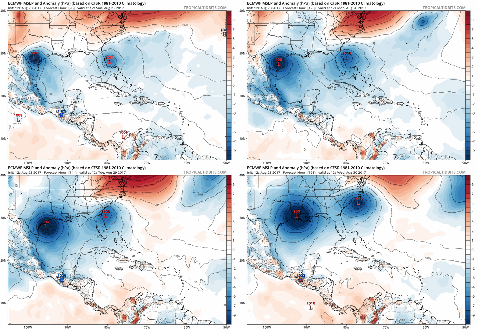
100-200 miles could make a HUGE difference between a decently named TC over the Gulf stream or nothing much over land.

 https://twitter.com/BigJoeBastardi/status/901860510022463489


The Euro hinted at this for one run 12z Wednesday August 23rd.

Image
0 likes   

User avatar
cycloneye
Admin
Admin
Posts: 143867
Age: 68
Joined: Thu Oct 10, 2002 10:54 am
Location: San Juan, Puerto Rico

Re: ATL: INVEST 92L - Discussion

#1645 Postby cycloneye » Sun Aug 27, 2017 12:52 pm

2 PM TWO up to 70%/70%

An elongated area of low pressure, previously located over northeast
Florida, has emerged over the western Atlantic and is now located
about 60 miles east of the coast of Georgia. Showers and
thunderstorms associated with this system have increased in
coverage and are gradually becoming better organized. The low
is likely to become a tropical depression or storm during the next
day or so before it merges with a cold front. Regardless of
development, the low is expected to cause increasing winds and rough
surf along the coasts of Georgia, the Carolinas, and Virginia
through mid-week. A tropical storm watch may be required for a
portion of the coast of North and South Carolina this afternoon.
Heavy rain is also expected to continue over portions of the Florida
peninsula during the next 24 hours. Please refer to products from
your local National Weather Service forecast office for more
information on this system.
* Formation chance through 48 hours...high...70 percent.
* Formation chance through 5 days...high...70 percent.
1 likes   
Visit the Caribbean-Central America Weather Thread where you can find at first post web cams,radars
and observations from Caribbean basin members Click Here

TheStormExpert

Re: ATL: INVEST 92L - Discussion

#1646 Postby TheStormExpert » Sun Aug 27, 2017 12:54 pm

Snippet from the 2pm TWO on 92L.

An elongated area of low pressure, previously located over northeast
Florida, has emerged over the western Atlantic and is now located
about 60 miles east of the coast of Georgia. Showers and
thunderstorms associated with this system have increased in
coverage and are gradually becoming better organized. The low
is likely to become a tropical depression or storm during the next
day or so before it merges with a cold front
. Regardless of
development, the low is expected to cause increasing winds and rough
surf along the coasts of Georgia, the Carolinas, and Virginia
through mid-week. A tropical storm watch may be required for a
portion of the coast of North and South Carolina this afternoon.
0 likes   

smithtim
Tropical Storm
Tropical Storm
Posts: 110
Joined: Thu Aug 28, 2008 1:43 pm

Re: ATL: INVEST 92L - Discussion

#1647 Postby smithtim » Sun Aug 27, 2017 12:58 pm

OuterBanker wrote:Low starting to wrap up now off the GA coast. Winds here constantly in the 25kt range (mostly from gradient). Not sure if it will get a name or to status, looks like a hybrid. That's a shame because no one takes a storm without a name seriously....


That's very true and if it does continue hopefully the mets on local TV their will bring some attention to it! I do see this storm having some potential effects on Coastal Georgia - Carolina. While it is not in a perfect environment the one thing to note is the water temperatures are very very warm https://www.nodc.noaa.gov/dsdt/cwtg/satl.html For example off Charleston & Savannah are almost 85 degrees and that's only a few degrees cooler than the water we just saw fuel Harvey! Please note in no way am I saying I see it bombing out like that, but I would not be surprised to see a quick forming TS or STS? Hopefully will just turn away NE on out to sea; maybe send some nice swell for the surfahs then zoom on out without causing any harm to lives / property... those are my prayers!
1 likes   
Disclaimer: while I am PhD who does research I'm rambling here so this post should be taken only for entertainment...use nhc.noaa.gov for official forecasts!

FLoridian living round here for a while: 2016 Matthew & 1998 Earl lived barrier island landfall. Also lived nearby/inland for: 2017 Irma & 2004 Frances,Jeanne & 1992 Andrew

User avatar
northjaxpro
S2K Supporter
S2K Supporter
Posts: 8900
Joined: Mon Sep 27, 2010 11:21 am
Location: Jacksonville, FL

Re: ATL: INVEST 92L - Discussion

#1648 Postby northjaxpro » Sun Aug 27, 2017 1:07 pm

This system will get really close to the Outer Banks of North Carolina and eventually farther up the Mid-Atlantic coast later this week. Interests living up in that area I would be paying close attention to what's happening with this storm as the day progresses and through the immediate short term.
1 likes   
NEVER, EVER SAY NEVER in the tropics and weather in general, and most importantly, with life itself!!

________________________________________________________________________________________

Fay 2008 Beryl 2012 Debby 2012 Colin 2016 Hermine 2016 Julia 2016 Matthew 2016 Irma 2017 Dorian 2019

seahawkjd
S2K Supporter
S2K Supporter
Posts: 632
Joined: Wed Sep 10, 2003 4:12 pm
Location: Morehead City, NC
Contact:

Re: ATL: INVEST 92L - Discussion

#1649 Postby seahawkjd » Sun Aug 27, 2017 1:24 pm

From what I can tell its getting little to no press locally. So we may be looking at watches at 5pm. It seems like we always start the school year with a watch or warning and sometimes end it the same way.
0 likes   
Gloria, Hugo, Emily, Bertha, Bonnie, Dennis (twice), Fran, Floyd, Isabel, Irene, Arthur, Matthew, Florence, Dorian (and many tropical storms and nor'easters).

User avatar
pgoss11
Category 2
Category 2
Posts: 702
Joined: Tue Sep 02, 2003 3:55 pm

Re: ATL: INVEST 92L - Discussion

#1650 Postby pgoss11 » Sun Aug 27, 2017 1:27 pm

seahawkjd wrote:From what I can tell its getting little to no press locally. So we may be looking at watches at 5pm. It seems like we always start the school year with a watch or warning and sometimes end it the same way.

Very little press about it here in Charleston SC. Winds have been increasing and I'm sure the waters will getting increasingly rough.
2 likes   

Sciencerocks
Category 5
Category 5
Posts: 8903
Age: 39
Joined: Thu Jul 06, 2017 1:51 am

Re: ATL: INVEST 92L - Discussion

#1651 Postby Sciencerocks » Sun Aug 27, 2017 1:30 pm

Looks to have developed convection over the LLC and is borderline tropical storm.

I'll guess that this will be upgraded by 11pm.
3 likes   

User avatar
northjaxpro
S2K Supporter
S2K Supporter
Posts: 8900
Joined: Mon Sep 27, 2010 11:21 am
Location: Jacksonville, FL

Re: ATL: INVEST 92L - Discussion

#1652 Postby northjaxpro » Sun Aug 27, 2017 1:38 pm

This invest has been around for 3 weeks!

92L has merged finally with that frontal boundary, but it is over the Gulf Stream now and I think it is classifiable now as a STS. It is developing nicely this afternoon. It will be a close call to see if it becomes fully tropical on characteristics. It has a very brief window for it becomefully tropical, probably about only the next 12-24 hours or so.
2 likes   
NEVER, EVER SAY NEVER in the tropics and weather in general, and most importantly, with life itself!!

________________________________________________________________________________________

Fay 2008 Beryl 2012 Debby 2012 Colin 2016 Hermine 2016 Julia 2016 Matthew 2016 Irma 2017 Dorian 2019

User avatar
weathaguyry
Category 5
Category 5
Posts: 1272
Age: 21
Joined: Wed Jun 15, 2016 5:16 am
Location: Long Island, NY

Re: ATL: INVEST 92L - Discussion

#1653 Postby weathaguyry » Sun Aug 27, 2017 1:43 pm

I'm keeping an extremely close eye on this here on Long island, one thing that is for sure is that the track will be closer than Gert's ever was!
1 likes   
My posts are only my opinions and NOT official forecasts. For official forecasts, consult the National Hurricane Center or the National Weather Service.

Irene 11', Sandy 12', Fay 20’, Isaias 20’, Elsa 21’, Henri 21’, Ida 21’

User avatar
Fishing
S2K Supporter
S2K Supporter
Posts: 67
Age: 65
Joined: Thu Sep 03, 2015 11:53 am
Location: Mount Pleasant, SC

Re: ATL: INVEST 92L - Discussion

#1654 Postby Fishing » Sun Aug 27, 2017 1:53 pm

pgoss11 wrote:
seahawkjd wrote:From what I can tell its getting little to no press locally. So we may be looking at watches at 5pm. It seems like we always start the school year with a watch or warning and sometimes end it the same way.

Very little press about it here in Charleston SC. Winds have been increasing and I'm sure the waters will getting increasingly rough.

Yes I am in Mount Pleasant and we have had some pretty big wind gusts. I'd imagine little to no press mostly because Harvey is so so devastating, and literally beyond words. I am praying them.
2 likes   

seahawkjd
S2K Supporter
S2K Supporter
Posts: 632
Joined: Wed Sep 10, 2003 4:12 pm
Location: Morehead City, NC
Contact:

Re: ATL: INVEST 92L - Discussion

#1655 Postby seahawkjd » Sun Aug 27, 2017 1:56 pm

Yeah everyone is understandably focused on Texas and Louisiana. We're going to get some rain and a little wind over the next couple of days.
2 likes   
Gloria, Hugo, Emily, Bertha, Bonnie, Dennis (twice), Fran, Floyd, Isabel, Irene, Arthur, Matthew, Florence, Dorian (and many tropical storms and nor'easters).

joey
Tropical Storm
Tropical Storm
Posts: 133
Joined: Sun Aug 14, 2016 9:11 pm

Re: ATL: INVEST 92L - Discussion

#1656 Postby joey » Sun Aug 27, 2017 1:58 pm

92L just might make it today but will it also pull the convection frow sw fl forming across the pinisnular with it :roll:
0 likes   

BobHarlem
Category 5
Category 5
Posts: 2034
Joined: Thu Oct 20, 2005 6:11 pm

Re: ATL: INVEST 92L - Discussion

#1657 Postby BobHarlem » Sun Aug 27, 2017 2:20 pm

Recon going to head out for 92l

WEATHER RECONNAISSANCE FLIGHTS
CARCAH, NATIONAL HURRICANE CENTER, MIAMI, FL.
0230 PM EDT SUN 27 AUGUST 2017
SUBJECT: TROPICAL CYCLONE PLAN OF THE DAY (TCPOD)
VALID 28/1100Z TO 29/1100Z AUGUST 2017
TCPOD NUMBER.....17-088

I. ATLANTIC REQUIREMENTS
1. SUSPECT AREA (NEAR SOUTHEAST U.S. COAST)
FLIGHT ONE -- TEAL 72 FLIGHT TWO -- TEAL 73
A. 28/1730Z A. 29/1130Z,1730Z
B AFXXX 01DDA INVEST B. AFXXX 0210A CYCLONE
C. 28/1530Z C. 29/0900Z
D. 31.7N 80.2W D. 34.0N 77.0W
E. 28/1730Z TO 28/2230Z E. 29/1100Z TO 29/1730Z
F. SFC TO 10,000 FT F. SFC TO 10,000 FT

2. SUCCEEDING DAY OUTLOOK: NEGATIVE
3. REMARKS:
A. INVEST MISSION SCHEDULED FOR 27/1800Z CANCELLED
BY NHC 27/1245Z.
B. MISSION ORIGINALLY TASKED FOR THE 28/1130Z,1730Z
FIXES WILL SLIP SIX HOURS AND BECOME FLIGHT ONE
ABOVE.
1 likes   

seahawkjd
S2K Supporter
S2K Supporter
Posts: 632
Joined: Wed Sep 10, 2003 4:12 pm
Location: Morehead City, NC
Contact:

Re: ATL: INVEST 92L - Discussion

#1658 Postby seahawkjd » Sun Aug 27, 2017 2:20 pm

Looks like the clouds are building in over the center, or is that the low moving west?

https://weather.us/satellite/800-w-320-n/satellite-infrared-superhd-5min.html#play
0 likes   
Gloria, Hugo, Emily, Bertha, Bonnie, Dennis (twice), Fran, Floyd, Isabel, Irene, Arthur, Matthew, Florence, Dorian (and many tropical storms and nor'easters).

User avatar
weathaguyry
Category 5
Category 5
Posts: 1272
Age: 21
Joined: Wed Jun 15, 2016 5:16 am
Location: Long Island, NY

Re: ATL: INVEST 92L - Discussion

#1659 Postby weathaguyry » Sun Aug 27, 2017 2:22 pm

One concern may actually be that if this becomes subtropical, the winds and rain may spread farther away from the center, and affect more people along the coast
1 likes   
My posts are only my opinions and NOT official forecasts. For official forecasts, consult the National Hurricane Center or the National Weather Service.

Irene 11', Sandy 12', Fay 20’, Isaias 20’, Elsa 21’, Henri 21’, Ida 21’

seahawkjd
S2K Supporter
S2K Supporter
Posts: 632
Joined: Wed Sep 10, 2003 4:12 pm
Location: Morehead City, NC
Contact:

Re: ATL: INVEST 92L - Discussion

#1660 Postby seahawkjd » Sun Aug 27, 2017 2:24 pm

BobHarlem wrote:Recon going to head out for 92l

WEATHER RECONNAISSANCE FLIGHTS
CARCAH, NATIONAL HURRICANE CENTER, MIAMI, FL.
0230 PM EDT SUN 27 AUGUST 2017
SUBJECT: TROPICAL CYCLONE PLAN OF THE DAY (TCPOD)
VALID 28/1100Z TO 29/1100Z AUGUST 2017
TCPOD NUMBER.....17-088

I. ATLANTIC REQUIREMENTS
1. SUSPECT AREA (NEAR SOUTHEAST U.S. COAST)
FLIGHT ONE -- TEAL 72 FLIGHT TWO -- TEAL 73
A. 28/1730Z A. 29/1130Z,1730Z
B AFXXX 01DDA INVEST B. AFXXX 0210A CYCLONE
C. 28/1530Z C. 29/0900Z
D. 31.7N 80.2W D. 34.0N 77.0W
E. 28/1730Z TO 28/2230Z E. 29/1100Z TO 29/1730Z
F. SFC TO 10,000 FT F. SFC TO 10,000 FT

2. SUCCEEDING DAY OUTLOOK: NEGATIVE
3. REMARKS:
A. INVEST MISSION SCHEDULED FOR 27/1800Z CANCELLED
BY NHC 27/1245Z.
B. MISSION ORIGINALLY TASKED FOR THE 28/1130Z,1730Z
FIXES WILL SLIP SIX HOURS AND BECOME FLIGHT ONE
ABOVE.


When is that going out? Tomorrow morning?
1 likes   
Gloria, Hugo, Emily, Bertha, Bonnie, Dennis (twice), Fran, Floyd, Isabel, Irene, Arthur, Matthew, Florence, Dorian (and many tropical storms and nor'easters).


Return to “2017”

Who is online

Users browsing this forum: No registered users and 56 guests