ATL: MARIA - Post-Tropical - Discussion
Moderator: S2k Moderators
-
Hurrilurker

- Category 2

- Posts: 738
- Joined: Mon Jun 09, 2003 3:32 pm
- Location: San Francisco, CA
Re: ATL: MARIA - Hurricane - Discussion
If you look at the St. Croix webcam (https://www.youtube.com/watch?v=3Q2CzQclKQc) you can see things are rapidly taking a turn for the worse. The cool thing about this camera is you can wind it back to see the progression. Just 30 minutes ago you can see it's a little windy and there are some waves lapping on the sidewalk, but nothing major. Compare to now (5:20 Pacific Time) and you can see the wind is now howling (intermittently for now depending on bands passing through) and visibility is decreasing. The camera is being buffeted on its mount and the amount of water pushing over the dock is increasing. I have a feeling that come morning light, a lot of those boats anchored in the harbor are going to be washed out to sea or piled up on shore. And bear in mind this camera is on the north side of the island.
2 likes


-
mrbagyo

- Category 5

- Posts: 3963
- Age: 33
- Joined: Thu Apr 12, 2012 9:18 am
- Location: 14.13N 120.98E
- Contact:
Re: ATL: MARIA - Hurricane - Discussion
HDGator wrote:Maria seems to be on rails towards the TJUA NEXRAD site in PR. Does anyone know what wind speed these are designed to withstand?
Any chance Maria poses a threat to the radar site?
if it's a direct hit to the radar and if Maria produce some unimaginable wind gust - you can imagine what Haiyan did to the Guiuan Radar - totally blown off radome - rated to 500kph (maybe an exageration, maybe not)
according to a PAGASA technician
1 likes
The posts in this forum are NOT official forecast and should not be used as such. They are just the opinion of the poster and may or may not be backed by sound meteorological data. They are NOT endorsed by any professional institution or storm2k.org. For official information, please refer to RSMC, NHC and NWS products.
-
supercane4867
- Category 5
- Posts: 4966
- Joined: Wed Nov 14, 2012 10:43 am
Re: ATL: MARIA - Hurricane - Discussion
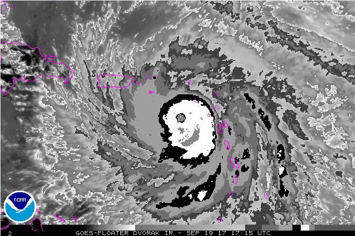
That bright orange eye on WV imagery is eerie looking.

6 likes

-
CrazyC83
- Professional-Met

- Posts: 34315
- Joined: Tue Mar 07, 2006 11:57 pm
- Location: Deep South, for the first time!
Re: ATL: MARIA - Hurricane - Discussion
GCANE wrote:What the .....
CMG seems to have wrapped almost around the eye if that is matched to Dvorak colors. Intermittent CDG as well.
2 likes

Re: ATL: MARIA - Hurricane - Discussion
Man it's going to be a very long night in st croix. I can't imagine going thru a cat 5 175 mph storm eyewall at night, and the devastation you'd wake up to. I have done night hurricanes before and daytime ones and it's just no comparison.
1 likes
-
Aric Dunn
- Category 5
- Posts: 21238
- Age: 43
- Joined: Sun Sep 19, 2004 9:58 pm
- Location: Ready for the Chase.
- Contact:
Re: ATL: MARIA - Hurricane - Discussion
PTPatrick wrote:Man it's going to be a very long night in st croix. I can't imagine going thru a cat 5 175 mph storm eyewall at night, and the devastation you'd wake up to. I have done night hurricanes before and daytime ones and it's just no comparison.
will be morning by the time the eye wall comes ashore.
1 likes
Note: If I make a post that is brief. Please refer back to previous posts for the analysis or reasoning. I do not re-write/qoute what my initial post said each time.
If there is nothing before... then just ask
Space & Atmospheric Physicist, Embry-Riddle Aeronautical University,
I believe the sky is falling...
If there is nothing before... then just ask
Space & Atmospheric Physicist, Embry-Riddle Aeronautical University,
I believe the sky is falling...

Re: ATL: MARIA - Hurricane - Discussion
PTPatrick wrote:Man it's going to be a very long night in st croix. I can't imagine going thru a cat 5 175 mph storm eyewall at night, and the devastation you'd wake up to. I have done night hurricanes before and daytime ones and it's just no comparison.
You would be able to sleep?!
3 likes

Re: ATL: MARIA - Hurricane - Discussion
CrazyC83 wrote:GCANE wrote:What the .....
CMG seems to have wrapped almost around the eye if that is matched to Dvorak colors. Intermittent CDG as well.
Correct. Much deeper convection than Irma, may I say. I'd throw it out there that it would be completely possible for that 168kt SMFR reading to be verifiable.
0 likes
Re: ATL: MARIA - Hurricane - Discussion
Aric Dunn wrote:PTPatrick wrote:Man it's going to be a very long night in st croix. I can't imagine going thru a cat 5 175 mph storm eyewall at night, and the devastation you'd wake up to. I have done night hurricanes before and daytime ones and it's just no comparison.
will be morning by the time the eye wall comes ashore.
Yeah it'll be close, 10 mph and 100 miles away, I guess I was thinking in mountain time it'll barely be day break when eye hits. But in that time zone they should be a couple hours into morning. Either way it'll suck and be a bad night.
3 likes
-
Hurrilurker
- Category 2
- Posts: 738
- Joined: Mon Jun 09, 2003 3:32 pm
- Location: San Francisco, CA
Re: ATL: MARIA - Hurricane - Discussion
Looks like a lot of St. Croix just lost power based on the webcam. Probably just anything with a solar panel and battery still operating. That appears to be a few street lights and the webcam itself. In the daylight shots you can see a bunch of solar panels on poles in the shot.
1 likes

Re: ATL: MARIA - Hurricane - Discussion
The center has drifted a little north. Probably a just the inner eyewall wobbling around the newer one forming. Probably bad news for St Croix and Vieques.
2 likes
-
FLpanhandle91

- Category 5
- Posts: 1039
- Age: 34
- Joined: Mon Sep 13, 2010 3:50 pm
- Location: Fort Walton Beach, FL
Re: ATL: MARIA - Hurricane - Discussion
GCANE wrote:Incredible
Saw the 3 three max rain-rates on recon.
EWRC seems to be in full swing.
0 likes
Re: ATL: MARIA - Hurricane - Discussion
GCANE wrote:Incredible
Saw the 3 three max rain-rates on recon.
Does that look slightly south of the NHC track?
Last edited by Ken711 on Tue Sep 19, 2017 7:51 pm, edited 1 time in total.
1 likes
-
1900hurricane

- Category 5
- Posts: 6063
- Age: 34
- Joined: Fri Feb 06, 2015 12:04 pm
- Location: Houston, TX
- Contact:
Re: ATL: MARIA - Hurricane - Discussion
That warm band in the CDO is weird.

2 likes
Contract Meteorologist. TAMU & MSST. Fiercely authentic, one of a kind. We are all given free will, so choose a life meant to be lived. We are the Masters of our own Stories.
Opinions expressed are mine alone.
Follow me on Twitter at @1900hurricane : Read blogs at https://1900hurricane.wordpress.com/
Opinions expressed are mine alone.
Follow me on Twitter at @1900hurricane : Read blogs at https://1900hurricane.wordpress.com/
-
'CaneFreak

- Category 5
- Posts: 1487
- Joined: Mon Jun 05, 2006 10:50 am
- Location: New Bern, NC
Re: ATL: MARIA - Hurricane - Discussion
Yes it is. A very intelligent professor at MIT by the name of Dr. Kerry Emanuel came up with a formula to calculate it. It is based on a lot of very intense thermodynamic equations but basically what he did was calculate what a perfectly efficient engine (hurricane) could potentially produce with no hindrances from shear, mid-level dry air, etc. That map that was posted is the result of crunching all of those equations. It is approaching it now.
galaxy401 wrote:'CaneFreak wrote:It's getting very close to its max potential intensity so this may be why it has stabilized.
Today is the first time I have ever heard of this term. Is "max potential intensity" legit?
4 likes
-
bob rulz
- Category 5
- Posts: 1711
- Age: 36
- Joined: Sat Jan 28, 2006 7:30 pm
- Location: Salt Lake City, Utah
Re: ATL: MARIA - Hurricane - Discussion
I remember that map being posted for Irma and Irma surpassed the theoretical maximum in that region.
Seems like it can produce a ballpark estimate but is not an exact science.
Seems like it can produce a ballpark estimate but is not an exact science.
1 likes
Re: ATL: MARIA - Hurricane - Discussion
Eye now visible with short range radar. Impressive. It's like knowing there's a comet striking you in few hours and nothing you can do about it...
2 likes
Personal Forecast Disclaimer:
The posts in this forum are NOT official forecast and should not be used as such. They are just the opinion of the poster and may or may not be backed by sound meteorological data. For official information, please refer to the NHC and NWS products.
The posts in this forum are NOT official forecast and should not be used as such. They are just the opinion of the poster and may or may not be backed by sound meteorological data. For official information, please refer to the NHC and NWS products.
Who is online
Users browsing this forum: No registered users and 218 guests