ATL: NATE - Post Tropical - Discussion
Moderator: S2k Moderators
-
PandaCitrus
- Category 1

- Posts: 424
- Joined: Mon Sep 04, 2017 2:44 pm
Re: ATL: NATE - Hurricane - Discussion
Imagine the damage if they both hit with Camille type winds. As catastrophic as Katrina was, it was nowhere near a worst case scenario. Outside of the surge zone, wind damage was moderate.
0 likes

Re: ATL: NATE - Hurricane - Discussion
PandaCitrus wrote:Is this the continental dry air that weakens almost all storms that approach the northern gulf?
Katrina fell apart and shredded before landfall. Opal did this too.
I don't think the folks who went through Katrina would say it fell apart and shredded!!
2 likes
-
tolakram
- Admin

- Posts: 20179
- Age: 62
- Joined: Sun Aug 27, 2006 8:23 pm
- Location: Florence, KY (name is Mark)
Re: ATL: NATE - Hurricane - Discussion
saved radar loop

0 likes
M a r k
- - - - -
Join us in chat: Storm2K Chatroom Invite. Android and IOS apps also available.
The posts in this forum are NOT official forecasts and should not be used as such. Posts are NOT endorsed by any professional institution or STORM2K.org. For official information and forecasts, please refer to NHC and NWS products.
-
Aric Dunn
- Category 5

- Posts: 21238
- Age: 43
- Joined: Sun Sep 19, 2004 9:58 pm
- Location: Ready for the Chase.
- Contact:
Re: ATL: NATE - Hurricane - Discussion
Sciencerocks wrote:Aric Dunn wrote:I mean very intense and very high rain rates...
How do you download a flash or Html5 loop and save it? A lot of the nws radar loops I can't save.

windows button-ALT-R it saves to a folder called captures. you then have to go to a website to convert the avi to a gif or whatever you want. then upload gif to a image site.
windows 10 ... not sure if other versions have it.
1 likes
Note: If I make a post that is brief. Please refer back to previous posts for the analysis or reasoning. I do not re-write/qoute what my initial post said each time.
If there is nothing before... then just ask
Space & Atmospheric Physicist, Embry-Riddle Aeronautical University,
I believe the sky is falling...
If there is nothing before... then just ask
Space & Atmospheric Physicist, Embry-Riddle Aeronautical University,
I believe the sky is falling...


Re: ATL: NATE - Hurricane - Discussion
There's your north turn...
The posts in this forum are NOT official forecast and should not be used as such. They are just the opinion of the poster and may or may not be backed by sound meteorological data. They are NOT endorsed by any professional institution or STORM2K. For official information, please refer to products from the National Hurricane Center and National Weather Service.
The posts in this forum are NOT official forecast and should not be used as such. They are just the opinion of the poster and may or may not be backed by sound meteorological data. They are NOT endorsed by any professional institution or STORM2K. For official information, please refer to products from the National Hurricane Center and National Weather Service.
1 likes
-
floridasun78
- Category 5
- Posts: 3755
- Joined: Sun May 17, 2009 10:16 pm
- Location: miami fl

Re: ATL: NATE - Hurricane - Discussion
Just as I had thought, the coc was found by the recon at 28.25N, 89.2W
Still moving NNW. At least to that point.
URNT12 KNHC 072114
VORTEX DATA MESSAGE AL162017
A. 07/20:40:10Z
B. 28 deg 14 min N
089 deg 12 min W
C. 850 mb 1278 m
D. 45 kt
E. 195 deg 20 nm
F. 271 deg 51 kt
G. 195 deg 20 nm
H. 982 mb
I. 19 C / 1527 m
J. 22 C / 1521 m
K. 18 C / NA
L. NA
M. NA
N. 1345 / 8
O. 0.02 / 3 nm
P. AF309 0916A NATE OB 04
MAX OUTBOUND AND MAX FL WIND 78 KT 039 / 25 NM 20:48:30Z
CNTR DROPSONDE SFC WIND 015 / 5 KT
SFC CNTR 360 / 2 NM FROM FL CNTR
;
0 likes
Re: ATL: NATE - Hurricane - Discussion
BULLETIN - EAS ACTIVATION REQUESTED
Tornado Warning
National Weather Service Tallahassee FL
424 PM CDT SAT OCT 7 2017
The National Weather Service in Tallahassee has issued a
* Tornado Warning for...
West central Bay County in the Panhandle of Florida...
* Until 500 PM CDT
* At 423 PM CDT, a severe thunderstorm capable of producing a tornado
was located near Panama City Beach, moving northwest at 35 mph.
HAZARD...Tornado.
SOURCE...Radar indicated rotation.
https://inws.ncep.noaa.gov/a/a.php?i=16333130
0 likes
-
ozonepete
- Professional-Met

- Posts: 4743
- Joined: Mon Sep 07, 2009 3:23 pm
- Location: From Ozone Park, NYC / Now in Brooklyn, NY
Re: ATL: NATE - Hurricane - Discussion
NDG wrote:ozonepete wrote:Bamagirl2408 wrote:
They have been saying NHC is wrong all day. My best friend has been sending me texts and videos. Wonder who is right?
Betting against NHC on track is a losing proposition 99% of the time.
Remember that they always go by the cone and not the center line, the Euro and GFS even though they are to the west of the center line of the forecast are on the western edge of the cone, which could still take and that would make the NHC 's track still correct.
I'm talking about where the storm center actually goes. The NHC final accuracy assessment on track goes by the exact center/eye location compared to the forecast, as we do for all of the models.
Btw your western scenario would make all 3 correct in a practical sense since the NHC keeps adjusting as the path changes while the GFS and the Euro don't have that luxury. So if it starts trending more westward now, the NHC will shift the track forecast west to come closer in line with the last runs of the Euro and GFS anyway, as you said, but that has nothing to do with the cone. If Nate stays on track the NHC does better than the Euro and GFS. If Nate trends more eastward the NHC will adjust eastward, doing better again, and the Euro and GFS will be left out in the rain.
1 likes

Re: ATL: NATE - Hurricane - Discussion
The portion that split off around western Cuba and is showing up just off coast of sw Florida--is that part of Nate, or is that the no name storm, or neither one?
0 likes
-
tolakram
- Admin
- Posts: 20179
- Age: 62
- Joined: Sun Aug 27, 2006 8:23 pm
- Location: Florence, KY (name is Mark)
Re: ATL: NATE - Models
18Z GFS
Slows down and maintains intensity until final landfall.

Slows down and maintains intensity until final landfall.
0 likes
M a r k
- - - - -
Join us in chat: Storm2K Chatroom Invite. Android and IOS apps also available.
The posts in this forum are NOT official forecasts and should not be used as such. Posts are NOT endorsed by any professional institution or STORM2K.org. For official information and forecasts, please refer to NHC and NWS products.
- - - - -
Join us in chat: Storm2K Chatroom Invite. Android and IOS apps also available.
The posts in this forum are NOT official forecasts and should not be used as such. Posts are NOT endorsed by any professional institution or STORM2K.org. For official information and forecasts, please refer to NHC and NWS products.
-
tolakram
- Admin
- Posts: 20179
- Age: 62
- Joined: Sun Aug 27, 2006 8:23 pm
- Location: Florence, KY (name is Mark)
Re: ATL: NATE - Models
GFS total precip

0 likes
M a r k
- - - - -
Join us in chat: Storm2K Chatroom Invite. Android and IOS apps also available.
The posts in this forum are NOT official forecasts and should not be used as such. Posts are NOT endorsed by any professional institution or STORM2K.org. For official information and forecasts, please refer to NHC and NWS products.
- - - - -
Join us in chat: Storm2K Chatroom Invite. Android and IOS apps also available.
The posts in this forum are NOT official forecasts and should not be used as such. Posts are NOT endorsed by any professional institution or STORM2K.org. For official information and forecasts, please refer to NHC and NWS products.
-
Aric Dunn
- Category 5
- Posts: 21238
- Age: 43
- Joined: Sun Sep 19, 2004 9:58 pm
- Location: Ready for the Chase.
- Contact:
Re: ATL: NATE - Hurricane - Discussion
some land friction may help this tighen up a little... but no deepening likely..
0 likes
Note: If I make a post that is brief. Please refer back to previous posts for the analysis or reasoning. I do not re-write/qoute what my initial post said each time.
If there is nothing before... then just ask
Space & Atmospheric Physicist, Embry-Riddle Aeronautical University,
I believe the sky is falling...
If there is nothing before... then just ask
Space & Atmospheric Physicist, Embry-Riddle Aeronautical University,
I believe the sky is falling...
-
tolakram
- Admin
- Posts: 20179
- Age: 62
- Joined: Sun Aug 27, 2006 8:23 pm
- Location: Florence, KY (name is Mark)
Re: ATL: NATE - Models
Here is the 12Z Euro total precip.

0 likes
M a r k
- - - - -
Join us in chat: Storm2K Chatroom Invite. Android and IOS apps also available.
The posts in this forum are NOT official forecasts and should not be used as such. Posts are NOT endorsed by any professional institution or STORM2K.org. For official information and forecasts, please refer to NHC and NWS products.
- - - - -
Join us in chat: Storm2K Chatroom Invite. Android and IOS apps also available.
The posts in this forum are NOT official forecasts and should not be used as such. Posts are NOT endorsed by any professional institution or STORM2K.org. For official information and forecasts, please refer to NHC and NWS products.

-
tolakram
- Admin
- Posts: 20179
- Age: 62
- Joined: Sun Aug 27, 2006 8:23 pm
- Location: Florence, KY (name is Mark)
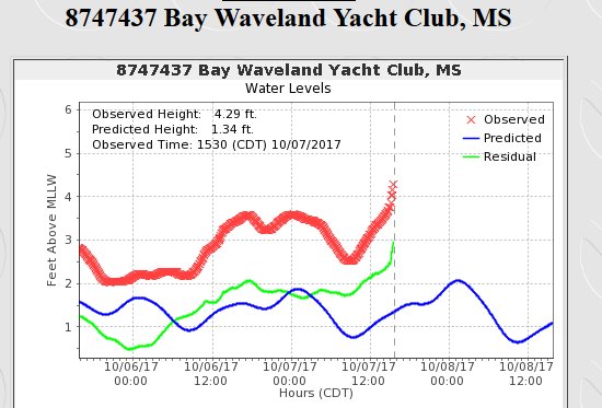
Re: ATL: NATE - Hurricane - Discussion
https://twitter.com/NWSNewOrleans/status/916768024073469952
NWS New Orleans ✔@NWSNewOrleans
Water levels continue to increase on Mississippi Gulf Coast! Life-threatening storm surge inundation of 7-11 feet later this evening. #MSwx
4:51 PM - Oct 7, 2017
NWS New Orleans ✔@NWSNewOrleans
Water levels continue to increase on Mississippi Gulf Coast! Life-threatening storm surge inundation of 7-11 feet later this evening. #MSwx
4:51 PM - Oct 7, 2017
0 likes
M a r k
- - - - -
Join us in chat: Storm2K Chatroom Invite. Android and IOS apps also available.
The posts in this forum are NOT official forecasts and should not be used as such. Posts are NOT endorsed by any professional institution or STORM2K.org. For official information and forecasts, please refer to NHC and NWS products.
- - - - -
Join us in chat: Storm2K Chatroom Invite. Android and IOS apps also available.
The posts in this forum are NOT official forecasts and should not be used as such. Posts are NOT endorsed by any professional institution or STORM2K.org. For official information and forecasts, please refer to NHC and NWS products.
Who is online
Users browsing this forum: No registered users and 51 guests