ATL: HARVEY - Post-Tropical - Discussion
Moderator: S2k Moderators
-
1900hurricane

- Category 5

- Posts: 6063
- Age: 34
- Joined: Fri Feb 06, 2015 12:04 pm
- Location: Houston, TX
- Contact:
Re: ATL: HARVEY - Hurricane - Discussion
Looks like the pattern transition from banding to CDO dominant is now complete. Bombs away.
1 likes
Contract Meteorologist. TAMU & MSST. Fiercely authentic, one of a kind. We are all given free will, so choose a life meant to be lived. We are the Masters of our own Stories.
Opinions expressed are mine alone.
Follow me on Twitter at @1900hurricane : Read blogs at https://1900hurricane.wordpress.com/
Opinions expressed are mine alone.
Follow me on Twitter at @1900hurricane : Read blogs at https://1900hurricane.wordpress.com/
-
tatertawt24
- Category 1

- Posts: 309
- Joined: Wed Oct 24, 2012 12:57 pm
Re: ATL: HARVEY - Hurricane - Discussion
AubreyStorm wrote:Vía Levi Cowan
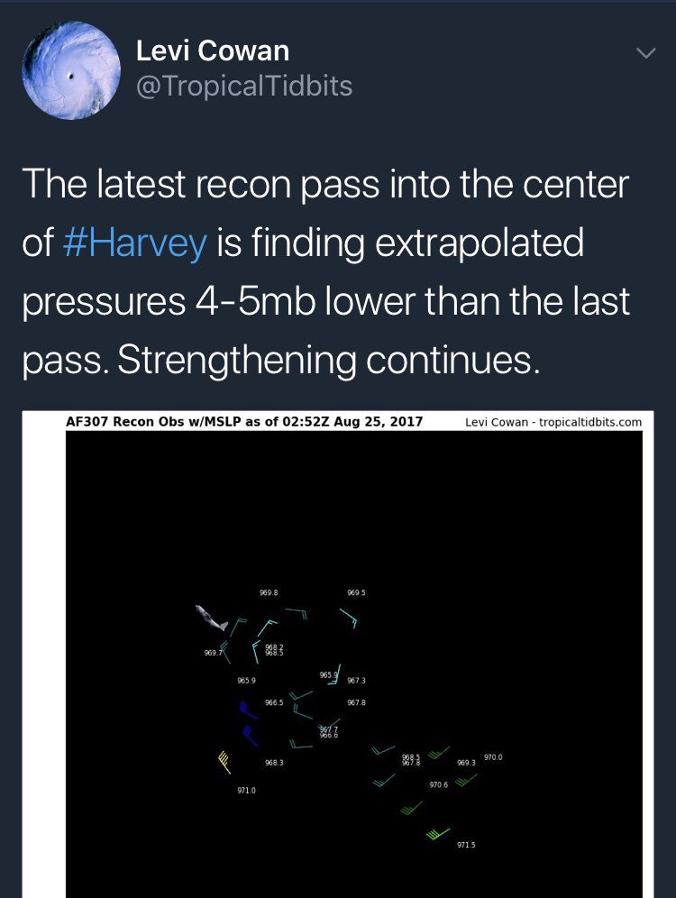
Wait, when was the last pass?
0 likes
Personal Forecast Disclaimer:
The posts in this forum are NOT official forecast and should not be used as such. They are just the opinion of the poster and may or may not be backed by sound meteorological data. They are NOT endorsed by any professional institution or storm2k.org. For official information, please refer to the NHC and NWS products.
The posts in this forum are NOT official forecast and should not be used as such. They are just the opinion of the poster and may or may not be backed by sound meteorological data. They are NOT endorsed by any professional institution or storm2k.org. For official information, please refer to the NHC and NWS products.
-
Aric Dunn
- Category 5
- Posts: 21238
- Age: 43
- Joined: Sun Sep 19, 2004 9:58 pm
- Location: Ready for the Chase.
- Contact:
Re: ATL: HARVEY - Hurricane - Discussion
025430 2517N 09450W 6944 02959 9791 +129 //// 042061 078 080 020 05
1 likes
Note: If I make a post that is brief. Please refer back to previous posts for the analysis or reasoning. I do not re-write/qoute what my initial post said each time.
If there is nothing before... then just ask
Space & Atmospheric Physicist, Embry-Riddle Aeronautical University,
I believe the sky is falling...
If there is nothing before... then just ask
Space & Atmospheric Physicist, Embry-Riddle Aeronautical University,
I believe the sky is falling...
-
USTropics
- Professional-Met

- Posts: 2738
- Joined: Sun Aug 12, 2007 3:45 am
- Location: Florida State University
Re: ATL: HARVEY - Hurricane - Discussion
Harvey has undergone quite an impressive evolution over the last 90 minutes:

1 likes
Re: ATL: HARVEY - Hurricane - Discussion
Soonercane wrote:I thought the NHC mentioned dry air intrusion/weakening? The pressure is down but that could be temporary right? Trying to make up mind whether to stay or leave (in Victoria on central TX coast).
Leave immediately. Regardless of whether this is a Cat 3 or a Cat 5 at landfall, this thing is dangerous, especially since you're on the coast. This thing could make a small NE wobble and put you in the crosshairs. Weather is unpredictable, but your safety can be ensured. Complete inundation is expected and unless you want to live without power for days, have hardly any access to emergency services, and be stuck in traffic when eventual forced evacuations are carried out, I'd leave now.
Last edited by Exalt on Thu Aug 24, 2017 10:08 pm, edited 1 time in total.
2 likes
-
SouthDadeFish

- Professional-Met
- Posts: 2835
- Joined: Thu Sep 23, 2010 2:54 pm
- Location: Miami, FL
- Contact:
Re: ATL: HARVEY - Hurricane - Discussion
Aric Dunn wrote:SouthDadeFish wrote:Aric Dunn wrote:Anyone know why they keep doing all the loopy loops in the eye each pass from the AF plane ?
Likely trying to find the true center of circulation for accurate center fix position and central pressure estimate.
its seems a little odd all of a sudden with this system. why even worry about a half mile difference?
I suppose another possibility is to avoid intense convective regions. Their path out of the eye just now was odd. Maybe avoiding very high reflectivities on radar and associated turbulence?
3 likes

Re: ATL: HARVEY - Hurricane - Discussion
Exalt wrote:If they find 85kt, could the forecast possibly be upped to a Cat 4 landfall? Weird things happen in the Gulf and while it'd be a longshot I wouldn't at all rule out a Cat 5 either, stranger things have happened.
This official forecast is for Harvey to be at 95 kts by 12z tomorrow morning. In other words, the NHC expects Harvey's max sustained winds to increase 20 kts in the next 9 hrs. We'll see what the max winds are in the NE quad in the coming few minutes as that quad is sampled, but, make no mistake, rapid intensification is needed (and expected) to bring Harvey to Cat 3 intensity by landfall. If the forecast is going to be wrong, I find it slightly more likely that it'll be wrong by overforecasting the intensity of Harvey than by underforecasting it. Of course, anything is possible, but it's the current forecast seems to be very fair (hey, who am I to judge how a forecast looks when that forecast is made by some of the best tropical cyclone forecasters in the world?)...
That band of intense convection may be a little parasitic, though it may be removed enough from the central core of the hurricane to not affect the overall intensity much. We're heading into the diurnal max in terms of convective intensity, and the cold cloud tops surrounding the eye are in line with the NHC forecast for continuation / resumption of rapid intensification.
2 likes

Re: ATL: HARVEY - Hurricane - Discussion
Soonercane wrote:I thought the NHC mentioned dry air intrusion/weakening? The pressure is down but that could be temporary right? Trying to make up mind whether to stay or leave (in Victoria on central TX coast).
14 minutes into this video, it explains how to find detailed info on what to expect in your area.
0 likes
-
GeneratorPower

- S2K Supporter

- Posts: 1648
- Age: 46
- Joined: Sun Dec 18, 2005 11:48 pm
- Location: Huntsville, AL
Re: ATL: HARVEY - Hurricane - Discussion
Unlikely but if the plane has an engine out they may be trying to dump fuel and or climb.
0 likes
-
Aric Dunn
- Category 5
- Posts: 21238
- Age: 43
- Joined: Sun Sep 19, 2004 9:58 pm
- Location: Ready for the Chase.
- Contact:
Re: ATL: HARVEY - Hurricane - Discussion
SouthDadeFish wrote:Aric Dunn wrote:SouthDadeFish wrote:
Likely trying to find the true center of circulation for accurate center fix position and central pressure estimate.
its seems a little odd all of a sudden with this system. why even worry about a half mile difference?
I suppose another possibility is to avoid intense convective regions. Their path out of the eye just now was odd. Maybe avoiding very high reflectivities on radar and associated turbulence?
Well I mean compare this to wilma ? I dont think that is an issue.. maybe lightning ? apparently its been above average with harvey thus far. ?
0 likes
Note: If I make a post that is brief. Please refer back to previous posts for the analysis or reasoning. I do not re-write/qoute what my initial post said each time.
If there is nothing before... then just ask
Space & Atmospheric Physicist, Embry-Riddle Aeronautical University,
I believe the sky is falling...
If there is nothing before... then just ask
Space & Atmospheric Physicist, Embry-Riddle Aeronautical University,
I believe the sky is falling...

Re: ATL: HARVEY - Hurricane - Discussion
hd44 wrote:ftp://ftp.nhc.noaa.gov/atcf/stext/17082500AL0917_ships.txt
Ships has some shear ... which lowers rapid intensification potential. Anyway expect some gradual intensification and a cat 2/3 landfall.
IMHO shear will not affect a RI cycle the way windshear affects usual intensifying storms! Rapid intensification is a phenomenon that is very little understood, and quite frankly not really predictable / forecastable! When it happens it happens very suddenly and often when it happens the storm will boom out so much ( I have seen jumping 2+ categories in < 1 advisory) that it pretty much just dominates everything around it ( or maybe dominating is not the right word, perhaps overcoming is better ). For this storm I see shear slowing a regularly intensifying storm just as NHC noted in their 11. But, for RI as of present the science is still blury at best but there are a few "necessary conditions" for RI to occur and I am not sure they are all met ( yet ) with Harvey? But even without RI it is very feasible to see cat 2/3 on landfall as NHC is listing on their 24 hours prediction eventhough jumping 25mph overnight to me is still a little interesting? They did not that their present intensity is "a little conservative" and if I recall some earlier recon showed mb readings that supported presently cat 2...
Again please note RI is really in uncharted waters for science and the only way to truly know what is going on is to monitor the data readings in real time from recon planes and any other sources like buoys, ships etc etc! And, for the good people of Texas coast, let us hope that this storm does not enter into a RI cycle!!!
BTW please note I am not a pro met nor any prof forecaster, rather just an academic researcher, so please do not in anyway take this as any forecast rather refer to nhc.noaa.gov and/or your local NWS offices!!!
0 likes
Disclaimer: while I am PhD who does research I'm rambling here so this post should be taken only for entertainment...use nhc.noaa.gov for official forecasts!
FLoridian living round here for a while: 2016 Matthew & 1998 Earl lived barrier island landfall. Also lived nearby/inland for: 2017 Irma & 2004 Frances,Jeanne & 1992 Andrew
FLoridian living round here for a while: 2016 Matthew & 1998 Earl lived barrier island landfall. Also lived nearby/inland for: 2017 Irma & 2004 Frances,Jeanne & 1992 Andrew
-
Aric Dunn
- Category 5
- Posts: 21238
- Age: 43
- Joined: Sun Sep 19, 2004 9:58 pm
- Location: Ready for the Chase.
- Contact:
Re: ATL: HARVEY - Hurricane - Discussion
radar is improving more and more.. satellite will improve more next..
0 likes
Note: If I make a post that is brief. Please refer back to previous posts for the analysis or reasoning. I do not re-write/qoute what my initial post said each time.
If there is nothing before... then just ask
Space & Atmospheric Physicist, Embry-Riddle Aeronautical University,
I believe the sky is falling...
If there is nothing before... then just ask
Space & Atmospheric Physicist, Embry-Riddle Aeronautical University,
I believe the sky is falling...


Re: ATL: HARVEY - Hurricane - Discussion
Definitely the northern and east eyewall have completed wrapping around a well-formed CDO now on GOES 16. Radar is impressive as well.
0 likes
The posts or stuff said are NOT an official forecast. Please look to the NHC and NWS for official forecasts and products.
Floyd-1999, Frances-2004, Jeanne-2004, Fay-2008, Beryl-2012, Debby-2012, Colin-2016, Hermine-2016, Julia-2016, Matthew-2016, Irma-2017, Elsa-2021, Idalia-2023, Debby-2024, Helene-2024.
Go Gators! Go Jags!
Floyd-1999, Frances-2004, Jeanne-2004, Fay-2008, Beryl-2012, Debby-2012, Colin-2016, Hermine-2016, Julia-2016, Matthew-2016, Irma-2017, Elsa-2021, Idalia-2023, Debby-2024, Helene-2024.
Go Gators! Go Jags!
Re: ATL: HARVEY - Hurricane - Discussion
WxGuy1 wrote:Exalt wrote:If they find 85kt, could the forecast possibly be upped to a Cat 4 landfall? Weird things happen in the Gulf and while it'd be a longshot I wouldn't at all rule out a Cat 5 either, stranger things have happened.
This official forecast is for Harvey to be at 95 kts by 12z tomorrow morning. In other words, the NHC expects Harvey's max sustained winds to increase 20 kts in the next 9 hrs. We'll see what the max winds are in the NE quad in the coming few minutes as that quad is sampled, but, make no mistake, rapid intensification is needed (and expected) to bring Harvey to Cat 3 intensity by landfall. If the forecast is going to be wrong, I find it slightly more likely that it'll be wrong by overforecasting the intensity of Harvey than by underforecasting it. Of course, anything is possible, but it's the current forecast seems to be very fair (hey, who am I to judge how a forecast looks when that forecast is made by some of the best tropical cyclone forecasters in the world?)...
That band of intense convection may be a little parasitic, though it may be removed enough from the central core of the hurricane to not affect the overall intensity much. We're heading into the diurnal max in terms of convective intensity, and the cold cloud tops surrounding the eye are in line with the NHC forecast for continuation / resumption of rapid intensification.
This is the one part of your answer I have an issue with. Matthew fully well bombed to our first Cat 5 since 2007 with that HUGE convective blob of a vestigial twin that everyone thought would hinder it, why couldn't Harvey?
Last edited by Exalt on Thu Aug 24, 2017 10:15 pm, edited 1 time in total.
1 likes

Re: ATL: HARVEY - Hurricane - Discussion
Cirrus may cover the eye in the short term, but it does appear than quick/rapid intensification should continue overnight.
1 likes
Re: ATL: HARVEY - Hurricane - Discussion
Anyone else noticing the tail Harvey has grown back by the Yucatan? I always look for those weird features hurricanes have. I remember with Hurricane Matthew, it was the "blob" that stayed with Matthew forever it seemed like to the northeast of the system.
3 likes
-
txwatcher91
- Category 5
- Posts: 1498
- Joined: Tue Aug 02, 2005 2:29 pm
Re: ATL: HARVEY - Hurricane - Discussion
As expected the CDO organization is nearing completion and the eye is warming. Pressure is about to start crashing and the eye will clear out rapidly when that happens, winds will begin to spike a few hours later. Everything seems right on schedule and the DMAX combined with higher TCHP waters is certainly helping as well.
0 likes
Re: ATL: HARVEY - Hurricane - Discussion
JaxGator wrote:Definitely the northern and east eyewall have completed wrapping around a well-formed CDO now on GOES 16. Radar is impressive as well.
This storm is looking pretty impressive, it's true.
And the GOES16 sat image is really awesome, too!!!
0 likes
Cleo - 1964, Betsy - 1965, David - 1979, Andrew - 1992, Charlie (Francis, Ivan, Jeanne) - 2004, Irma - 2017, Ian - 2022, Milton - 2024
Re: ATL: HARVEY - Hurricane - Discussion
BRweather wrote:Anyone else noticing the tail Harvey has grown back by the Yucatan? I always look for those weird features hurricanes have. I remember with Hurricane Matthew, it was the "blob" that stayed with Matthew forever it seemed like to the northeast of the system.
Right now I'd say it's removed enough to not worry about, however Matthew still did bomb out with that blob so I wouldn't discount it even if it does tighten in.
0 likes
-
OverlandHurricane
- S2K Supporter
- Posts: 58
- Joined: Thu Aug 28, 2008 4:50 pm
- Location: Minnesota
Re: RE: Re: ATL: HARVEY - Hurricane - Discussion
I think the last major landfall in the Atlantic was either Dean or Felix.Exalt wrote:100% this is getting retired. First hurricane to make landfall as a major since Wilma? The sheer amount of flooding this is about to cause? God I can't bear to think about the devastation.
0 likes
Who is online
Users browsing this forum: No registered users and 36 guests