
ATL: BRET - Remnants - Discussion
Moderator: S2k Moderators
Re: ATL: TWO - Potential Tropical Cyclone - Discussion
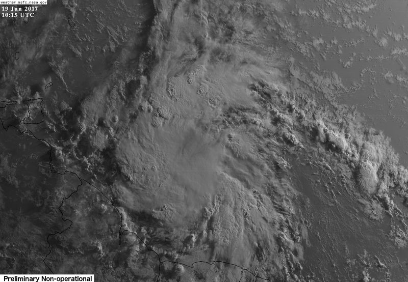
Vis satellite this morning has that look.
1 likes
-
hurricanes1234
- Category 5

- Posts: 2908
- Joined: Sat Jul 28, 2012 6:19 pm
- Location: Trinidad and Tobago
Re: ATL: TWO - Potential Tropical Cyclone - Discussion
Really starting to close in on the islands now. I'm very eager to see what the plane finds later today.
0 likes
PLEASE NOTE: With the exception of information from weather agencies that I may copy and paste here, my posts will NEVER be official, since I am NOT a meteorologist. They are solely my amateur opinion, and may or may not be accurate. Therefore, please DO NOT use them as official details, particularly when making important decisions. Thank you.
-
cycloneye

- Admin

- Posts: 149283
- Age: 69
- Joined: Thu Oct 10, 2002 10:54 am
- Location: San Juan, Puerto Rico
Re: ATL: TWO - Potential Tropical Cyclone - Discussion
Does those warnings as Potential Cyclone TWO count for the ACE? (Accumulative Cyclone Energy) I ask as I see that Weatherbell has included the units so far at this stage.
http://models.weatherbell.com/tropical.php
http://models.weatherbell.com/tropical.php
0 likes
Visit the Caribbean-Central America Weather Thread where you can find at first post web cams,radars
and observations from Caribbean basin members Click Here
and observations from Caribbean basin members Click Here
-
weathaguyry

- Category 5
- Posts: 1273
- Age: 22
- Joined: Wed Jun 15, 2016 5:16 am
- Location: Long Island, NY
Re: ATL: TWO - Potential Tropical Cyclone - Discussion
Any idea when we may get another ASCAT pass?
0 likes
My posts are only my opinions and NOT official forecasts. For official forecasts, consult the National Hurricane Center or the National Weather Service.
Irene 11', Sandy 12', Fay 20’, Isaias 20’, Elsa 21’, Henri 21’, Ida 21’
Irene 11', Sandy 12', Fay 20’, Isaias 20’, Elsa 21’, Henri 21’, Ida 21’
Re: ATL: TWO - Potential Tropical Cyclone - Discussion
weathaguyry wrote:Any idea when we may get another ASCAT pass?
Later this morning, if it catches it.
1 likes

-
weathaguyry
- Category 5
- Posts: 1273
- Age: 22
- Joined: Wed Jun 15, 2016 5:16 am
- Location: Long Island, NY
Re: ATL: TWO - Potential Tropical Cyclone - Discussion
0 likes
My posts are only my opinions and NOT official forecasts. For official forecasts, consult the National Hurricane Center or the National Weather Service.
Irene 11', Sandy 12', Fay 20’, Isaias 20’, Elsa 21’, Henri 21’, Ida 21’
Irene 11', Sandy 12', Fay 20’, Isaias 20’, Elsa 21’, Henri 21’, Ida 21’
-
Gustywind

- Category 5
- Posts: 12334
- Joined: Mon Sep 03, 2007 7:29 am
- Location: Baie-Mahault, GUADELOUPE
Re: ATL: TWO - Potential Tropical Cyclone - Discussion
Dvorak numbers continue to climb now with 2.0/2:0  ...
...
DATE/TIME LAT LON CLASSIFICATION STORM
19/0545 UTC 8.2N 53.6W T2.0/2.0 02L -- Atlantic
18/2345 UTC 7.7N 51.6W T1.5/1.5 02L -- Atlantic
DATE/TIME LAT LON CLASSIFICATION STORM
19/0545 UTC 8.2N 53.6W T2.0/2.0 02L -- Atlantic
18/2345 UTC 7.7N 51.6W T1.5/1.5 02L -- Atlantic
1 likes
-
Gustywind
- Category 5
- Posts: 12334
- Joined: Mon Sep 03, 2007 7:29 am
- Location: Baie-Mahault, GUADELOUPE
Re: ATL: TWO - Potential Tropical Cyclone - Discussion
Tropical Weather Discussion
NWS National Hurricane Center Miami FL
710 AM EDT Mon Jun 19 2017
...SPECIAL FEATURES...
The center of Potential Tropical Cyclone Two at 19/1200 UTC is
near 8.3N 53.5W, or about 550 nm to the ESE of Trinidad. It is
moving westward, 280 degrees, 20 knots. The maximum wind speeds
are 35 kt with gusts to 45 knots. The minimum central pressure is
1005 mb. Convective precipitation: scattered moderate to strong
from 07N to 12N between 53W and 59W. Broken to overcast
multilayered clouds, a lot of high-level cloudiness, and other
possible rainshowers cover the Atlantic Ocean from 12N to 23N
between 48W and 60W. Please read the NHC Potential Tropical
Cyclone Forecast/Advisory under AWIPS/WMO headers MIATCMAT2/WTNT22
KNHC, and the Intermediate Public Forecast/Advisory under the
AWIPS/WMO headers MIATCPAT2/WTNT32 KNHC for more details.
1 likes

Re: ATL: TWO - Potential Tropical Cyclone - Discussion
djones65 wrote:Hammy?
You have made 8 posts in less than three pages saying the same thing. We get it. You don't think this will be named Bret.
I think this is a tropical cyclone and will be named Bret. We will have to wait and see.
She has, but she's been proven right so far. Aric mentioned thinking that recon will find a 50 knot storm. We'll see. I recall Hammy getting lots of flak from us last year (I think it was last year) and she was right then too.
Last edited by abajan on Mon Jun 19, 2017 7:21 am, edited 2 times in total.
1 likes
Re: ATL: TWO - Potential Tropical Cyclone - Discussion
hurricanes1234 wrote:Really starting to close in on the islands now. I'm very eager to see what the plane finds later today.
Should it find a hurricane, the warning would be too late for Trinidad and Tobago.
0 likes

Re: ATL: TWO - Potential Tropical Cyclone - Discussion
cycloneye wrote:Does those warnings as Potential Cyclone TWO count for the ACE? (Accumulative Cyclone Energy) I ask as I see that Weatherbell has included the units so far at this stage.
http://models.weatherbell.com/tropical.php
No but the weatherbell algorithm sees a numbered system with 35 KT winds. It doesn't know any better.
1 likes

Re: ATL: TWO - Potential Tropical Cyclone - Discussion
this morning reports from hurricane correspondents on Grenada
http://www.stormcarib.com/reports/current/grenada.shtm
and Trinidad & Tobago
http://www.stormcarib.com/reports/curre ... idad.shtml
http://www.stormcarib.com/reports/current/grenada.shtm
and Trinidad & Tobago
http://www.stormcarib.com/reports/curre ... idad.shtml
3 likes
Too many hurricanes to remember
-
TheStormExpert
-
Gustywind
- Category 5
- Posts: 12334
- Joined: Mon Sep 03, 2007 7:29 am
- Location: Baie-Mahault, GUADELOUPE
Re: ATL: TWO - Potential Tropical Cyclone - Discussion
Thanks Barbara, very interresting reports 
Glad to see you back in the action on the board .
.
Regards.
Gustywind
Glad to see you back in the action on the board
Regards.
Gustywind
2 likes
-
northjaxpro

- S2K Supporter

- Posts: 8900
- Joined: Mon Sep 27, 2010 11:21 am
- Location: Jacksonville, FL
Re: ATL: TWO - Potential Tropical Cyclone - Discussion
weathaguyry wrote::uarrow: It really has "that look" this morning
Yes it does . I think we likely have a tropical cyclone now. I would be quite surprised if Recon does not find a closed off circulation later today.
Last edited by northjaxpro on Mon Jun 19, 2017 7:54 am, edited 1 time in total.
1 likes
NEVER, EVER SAY NEVER in the tropics and weather in general, and most importantly, with life itself!!
________________________________________________________________________________________
Fay 2008 Beryl 2012 Debby 2012 Colin 2016 Hermine 2016 Julia 2016 Matthew 2016 Irma 2017 Dorian 2019
________________________________________________________________________________________
Fay 2008 Beryl 2012 Debby 2012 Colin 2016 Hermine 2016 Julia 2016 Matthew 2016 Irma 2017 Dorian 2019
-
hurricanes1234
- Category 5
- Posts: 2908
- Joined: Sat Jul 28, 2012 6:19 pm
- Location: Trinidad and Tobago
Re: ATL: TWO - Potential Tropical Cyclone - Discussion
When is the mission carded to begin?
.
.
0 likes
PLEASE NOTE: With the exception of information from weather agencies that I may copy and paste here, my posts will NEVER be official, since I am NOT a meteorologist. They are solely my amateur opinion, and may or may not be accurate. Therefore, please DO NOT use them as official details, particularly when making important decisions. Thank you.
-
cycloneye
- Admin
- Posts: 149283
- Age: 69
- Joined: Thu Oct 10, 2002 10:54 am
- Location: San Juan, Puerto Rico
Re: ATL: TWO - Potential Tropical Cyclone - Discussion
hurricanes1234 wrote:When is the mission carded to begin?
.
Plane departs at 11 AM EDT from Florida
2 likes
Visit the Caribbean-Central America Weather Thread where you can find at first post web cams,radars
and observations from Caribbean basin members Click Here
and observations from Caribbean basin members Click Here
-
Hypercane_Kyle

- Category 5
- Posts: 3465
- Joined: Sat Mar 07, 2015 7:58 pm
- Location: Cape Canaveral, FL
Re: ATL: TWO - Potential Tropical Cyclone - Discussion
cycloneye wrote:hurricanes1234 wrote:When is the mission carded to begin?
.
Plane departs at 11 AM EDT from Florida
Flying out of Tampa instead of St. Croix?
0 likes
My posts are my own personal opinion, defer to the National Hurricane Center (NHC) and other NOAA products for decision making during hurricane season.
Who is online
Users browsing this forum: No registered users and 23 guests