Indeed, when last year Sab classified 90M nobody discussed its origin. Numa has not been named but has tropical characteristics equal to 90M, and longer life. Noaa has written something about this, but it is not consistent: Defines it first as "hybrid tropical storm" after "tropical-like storm" after "hybrid storm, with tropical and subtropical characteristics" (Exist also the midway between tropical and subtropical cyclone now?..bha!); In the text adds "The Mediterranean Sea typically is not conducive to tropical cyclone development", but own just they have classified 01M-2011, and 90M2016, and the Mediterranean is inserted between them formation basin (even if they do not follow the mediterranean systems anymore).
Numa is a"normal" tropical transition like Karl nov1980, Vince oct2005, Grace oct2009, Alex jan2016, Arlene apr 2017 (19-23°c sea surface and 30-40 latitude). The operational model data used by Hart often are unable to resolve the small-scale warm core cyclones of the Mediterranean area.
reported 293mm of rain in 24h over Salento (Apulia region) and 83km/h wind and discrete storm surge in Corigliano Calabro gulf..many flooded areas.
Landfall over Greece produced discrete storm surge over Kefalonia, Ithaki, Lefkada, Nafpaktos, Mesolongi, Patrasso, damages some boats, trees cut down. broken some road signage. many flooded areas.
110km/h (60kt) wind report west Khefalonia coast during the landfall. 998 hpa
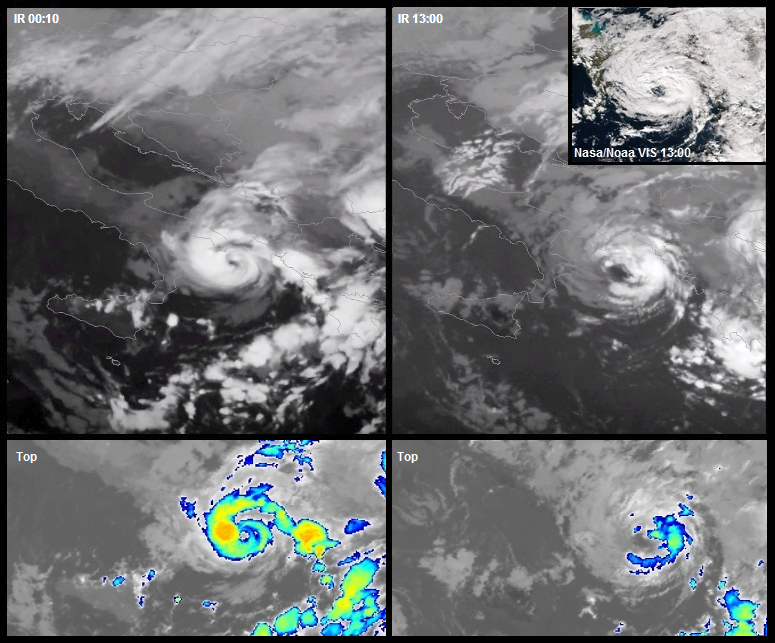
You can see on the web many Numa's images on the visible day 18, beautiful, however, despite the features of an eye, had lost a lot of convection. Numa had perfect tropical convection when it was by night, between 18:00 and 06:00, with peak intensity between 23:00 and 02:00. It was a real misfortune because we would have had an image of a perfect tropical cyclone. I am sure that this has contributed to downgrading it. Numa is t3.0/t3.5 tropical storm for my opinion.