ATL: CINDY - Post-Tropical - Discussion

Moderator: S2k Moderators

Message
Author
RL3AO
Moderator-Pro Met
Moderator-Pro Met
Posts: 16308
Joined: Thu Jun 14, 2007 10:03 pm
Location: NC

Re: ATL: INVEST 93L - Models

#61 Postby RL3AO » Sat Jun 17, 2017 5:42 pm

CrazyC83 wrote:I'm still puzzled on how it can end up in the Florida Panhandle with a fairly stout ridge over the Mississippi Valley - the flow would be clockwise around that? Unless a front is coming in and sucking it northeast?


Where are you seeing the ridge over the Mississippi Valley? The dominant ridge in North America is over the SW US (hence the reason temps in Phoneix are approaching 120F this week).
Image
0 likes   

User avatar
wxman57
Moderator-Pro Met
Moderator-Pro Met
Posts: 22512
Age: 66
Joined: Sat Jun 21, 2003 8:06 pm
Location: Houston, TX (southwest)

Re: ATL: INVEST 93L - Discussion

#62 Postby wxman57 » Sat Jun 17, 2017 5:45 pm

I was comparing the upper-level flow for Monday PM between the EC and the GFS. GFS has a deep upper low over the NW Gulf through Tuesday into Wednesday. Euro backs the upper low west to Laredo, TX by Monday PM and builds a ridge over the Gulf. Thus, the GFS taking the system north. Which one has the right upper-air pattern? EC has ruled that area in recent months.
3 likes   

User avatar
Hurricaneman
Category 5
Category 5
Posts: 7285
Age: 43
Joined: Tue Aug 31, 2004 3:24 pm
Location: central florida

Re: ATL: INVEST 93L - Models

#63 Postby Hurricaneman » Sat Jun 17, 2017 5:48 pm

Could be typical weirdness of the GFS
0 likes   

tolakram
Admin
Admin
Posts: 19184
Age: 61
Joined: Sun Aug 27, 2006 8:23 pm
Location: Florence, KY (name is Mark)

Re: ATL: INVEST 93L - Discussion

#64 Postby tolakram » Sat Jun 17, 2017 6:05 pm

Another long saved loop.

http://i.imgur.com/vrf9esv.gif
0 likes   
M a r k
- - - - -
Join us in chat: Storm2K Chatroom Invite. Android and IOS apps also available.

The posts in this forum are NOT official forecasts and should not be used as such. Posts are NOT endorsed by any professional institution or STORM2K.org. For official information and forecasts, please refer to NHC and NWS products.

txwatcher91
Category 5
Category 5
Posts: 1498
Joined: Tue Aug 02, 2005 2:29 pm

Re: ATL: INVEST 93L - Models

#65 Postby txwatcher91 » Sat Jun 17, 2017 6:10 pm

Hurricaneman wrote:Could be typical weirdness of the GFS


I doubt it. The CMC has shown this for days and the 18z NAM did shift North a bit as well. It really depends on how quickly the energy consolidates and if that piece that splits off can take over. The GFS and CMC show that while Euro doesn't.
0 likes   

WeatherEmperor
S2K Supporter
S2K Supporter
Posts: 4806
Age: 40
Joined: Thu Sep 04, 2003 2:54 pm
Location: South Florida

Re: ATL: INVEST 93L - Models

#66 Postby WeatherEmperor » Sat Jun 17, 2017 6:15 pm

I think now would be a good reminder to point out that last year we had an epic battle between the GFS and Euro for 99L that eventually became Hermine. Up until 72-96 hours before passing through the FL Straights the Euro had the system hitting South Florida as a TS/Cat1 storm...whereas the GFS had a weak low pressure moving through. The Euro eventually abandoned its solution and went to the GFS's solution...creating one of the biggest busts the Euro has seen.

I am not trying to imply the same will happen again...but just want to point it out that the GFS is not always wrong.

I am not sure about the level of bustation (is that even a real word?) that will happen here but considering the timeframe is within 72 hours, a bust of some proportions will take place by the Euro or GFS once again.


Sent from my iPhone 7 using Tapatalk
1 likes   

User avatar
NDG
S2K Supporter
S2K Supporter
Posts: 14951
Joined: Sun Jul 09, 2006 10:14 pm
Location: Orlando, FL

Re: ATL: INVEST 93L - Discussion

#67 Postby NDG » Sat Jun 17, 2017 6:18 pm

The Island of Roatan reporting pressure now down to 1006 mb with a light west wind, Belize with a northerly wind pressure down to 1006 mb, pressures continue to drop across the NW Caribbean.
5 likes   

User avatar
cycloneye
Admin
Admin
Posts: 139756
Age: 67
Joined: Thu Oct 10, 2002 10:54 am
Location: San Juan, Puerto Rico

Re: ATL: INVEST 93L - Discussion

#68 Postby cycloneye » Sat Jun 17, 2017 6:31 pm

8 PM TWO: 40%-80%

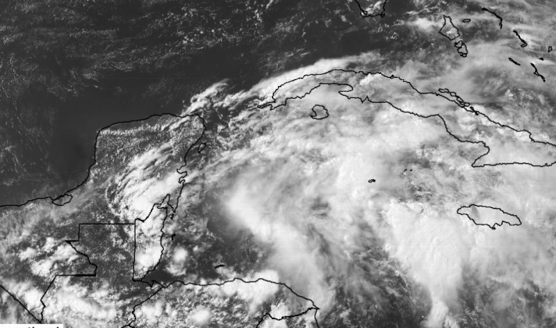
A broad area of low pressure located over the northwestern Caribbean
Sea is producing a large area of disorganized showers and
thunderstorms. Gradual development of this system is expected while
it moves slowly northwestward across the Yucatan Peninsula on Sunday
and over the southern or central Gulf of Mexico early next week,
where a tropical or subtropical cyclone is likely to form.
Regardless of development, heavy rains are expected over portions of
Central America, the Yucatan Peninsula, Jamaica, the Cayman Islands,
and western Cuba during the next several days. An Air Force Reserve
Hurricane Hunter aircraft is scheduled to investigate this system on
Sunday, if necessary.
* Formation chance through 48 hours...medium...40 percent.
* Formation chance through 5 days...high...80 percent.
0 likes   
Visit the Caribbean-Central America Weather Thread where you can find at first post web cams,radars
and observations from Caribbean basin members Click Here

Alyono
Professional-Met
Professional-Met
Posts: 6961
Joined: Fri Apr 26, 2013 3:52 pm
Location: Texas Coast

Re: ATL: INVEST 93L - Models

#69 Postby Alyono » Sat Jun 17, 2017 6:37 pm

South Texas Storms wrote:Curious to see what the HWRF shows in about an hour.


it is of no help at all. It's tracking the Yucatan. Doesn't bring anything offshore until Tuesday, which is very late. Seems like a moving nest issue
1 likes   

psyclone
S2K Supporter
S2K Supporter
Posts: 4511
Joined: Wed Aug 24, 2005 9:04 pm
Location: palm harbor fl

Re: ATL: INVEST 93L - Discussion

#70 Postby psyclone » Sat Jun 17, 2017 6:39 pm

typical june slow cooker genesis...always dangerous for a board of weather enthusiasts desirous of microwave results. I'd put all of my chips (except for 1) on the Euro. Nevertheless, deep moisture with PWATs AOA 2" will be advecting over the Florida peninsula starting tomorrow and considering the eastward extent of the convection this disturbed area has been kicking off, it seems it may have impacts on areas well away from it's eventual center/path. Just came back from a swim in the Gulf...water was clear, tranquil and turquois with a temp in the mid 80's. feels like hurricane season for sure.
1 likes   

stormreader
Category 5
Category 5
Posts: 1242
Joined: Fri Jun 24, 2011 10:58 am

Re: ATL: INVEST 93L - Models

#71 Postby stormreader » Sat Jun 17, 2017 6:44 pm

WeatherEmperor wrote:I think now would be a good reminder to point out that last year we had an epic battle between the GFS and Euro for 99L that eventually became Hermine. Up until 72-96 hours before passing through the FL Straights the Euro had the system hitting South Florida as a TS/Cat1 storm...whereas the GFS had a weak low pressure moving through. The Euro eventually abandoned its solution and went to the GFS's solution...creating one of the biggest busts the Euro has seen.

I am not trying to imply the same will happen again...but just want to point it out that the GFS is not always wrong.

I am not sure about the level of bustation (is that even a real word?) that will happen here but considering the timeframe is within 72 hours, a bust of some proportions will take place by the Euro or GFS once again.


And really, last year both of the models struggled. The long range confidence that seemed to be becoming the norm faltered. Worst example was with the season's major player "Mathew". Both models had it several hundred miles off the Atlantic coast (even near Bermuda). Instead it hugged the coast up into Carolina. In general I like the climo angle. In this case Euro seems more reasonable. If high over SW stays strong then system into Tex-Mex. Some weakening allows drift up Texas coast. Going with that.

Sent from my iPhone 7 using Tapatalk
Last edited by tolakram on Sat Jun 17, 2017 6:52 pm, edited 1 time in total.
Reason: fixed quote
0 likes   

stormreader
Category 5
Category 5
Posts: 1242
Joined: Fri Jun 24, 2011 10:58 am

Re: ATL: INVEST 93L - Models

#72 Postby stormreader » Sat Jun 17, 2017 6:47 pm

Sorry to Weather Emperor about messing up that reply to his post about model performance last year. My reply actually starts with the words "And really...."
0 likes   

bamajammer4eva
Category 4
Category 4
Posts: 907
Joined: Sun Apr 18, 2010 3:21 am
Location: Ozark, AL

Re: ATL: INVEST 93L - Models

#73 Postby bamajammer4eva » Sat Jun 17, 2017 6:49 pm

If the GFS were correct PC Beach would have a wet week coming up.

Image

NWS Tallahassee is Euro all the way though

Guidance starts to
diverge on Monday in regards to the tropical disturbance expected in
the Gulf. The GFS brings the low and moisture northward on Monday
whereas the ECWMF and UKMET keep the disturbance further south and
west. While the track will have more significant impacts on the
long term forecast, regardless of the ECMWF/UKMET or the GFS
solution, should see an increase in moisture and PoPs for Monday
into Monday night.


.LONG TERM [Tuesday Through Saturday]...

Large differences exist between model solutions and the positioning
of the tropical disturbance in the long term. The GFS brings the
system into the eastern/central Gulf with impacts to the CWA,
however the ECMWF keeps the system south and pushes it into the
western Gulf, with little impact to the CWA. Have trended toward the
ECWMF solution and while it does bring some increased moisture to
the CWA early in the week, it is drier for the second half of the
week. If the ECMWF solution does verify, the PoP forecast for the
second half of the week may be high. While the forecast leans toward
the solution of the tropical disturbance remaining well south and
west of the area
, if the GFS solution were to verify, much more rain
would be expected and this would have to be watched closely in
regards to the flood potential.
0 likes   

User avatar
NDG
S2K Supporter
S2K Supporter
Posts: 14951
Joined: Sun Jul 09, 2006 10:14 pm
Location: Orlando, FL

Re: ATL: INVEST 93L - Discussion

#74 Postby NDG » Sat Jun 17, 2017 6:53 pm

Good night 93L, you are one heck of a big system, typical of a monsoonal low that takes a little while to get going but you bring plenty of heavy tropical rains.

Image
1 likes   

User avatar
Kingarabian
S2K Supporter
S2K Supporter
Posts: 15462
Joined: Sat Aug 08, 2009 3:06 am
Location: Honolulu, Hawaii

Re: ATL: INVEST 93L - Models

#75 Postby Kingarabian » Sat Jun 17, 2017 7:22 pm

12z Euro Parallel:

Moves the system into WGOM, drops the pressure to 999mb, then a trough picks it up, starts moving N, begins to weaken and then NE with landfall over Texas near the Houston area as a 1004mb TS.
0 likes   
RIP Kobe Bryant

txwatcher91
Category 5
Category 5
Posts: 1498
Joined: Tue Aug 02, 2005 2:29 pm

Re: ATL: INVEST 93L - Models

#76 Postby txwatcher91 » Sat Jun 17, 2017 7:33 pm

stormreader wrote:
WeatherEmperor wrote:I think now would be a good reminder to point out that last year we had an epic battle between the GFS and Euro for 99L that eventually became Hermine. Up until 72-96 hours before passing through the FL Straights the Euro had the system hitting South Florida as a TS/Cat1 storm...whereas the GFS had a weak low pressure moving through. The Euro eventually abandoned its solution and went to the GFS's solution...creating one of the biggest busts the Euro has seen.

I am not trying to imply the same will happen again...but just want to point it out that the GFS is not always wrong.

I am not sure about the level of bustation (is that even a real word?) that will happen here but considering the timeframe is within 72 hours, a bust of some proportions will take place by the Euro or GFS once again.


And really, last year both of the models struggled. The long range confidence that seemed to be becoming the norm faltered. Worst example was with the season's major player "Mathew". Both models had it several hundred miles off the Atlantic coast (even near Bermuda). Instead it hugged the coast up into Carolina. In general I like the climo angle. In this case Euro seems more reasonable. If high over SW stays strong then system into Tex-Mex. Some weakening allows drift up Texas coast. Going with that.

Sent from my iPhone 7 using Tapatalk


Don't forget the GFS did much better than the Euro. It wasn't perfect but consistently had a Florida to NC threat for days while the Euro was showing out to sea to Bermuda, everyone thought that would happen because it's the Euro... and the GFS solution was much closer to what transpired. The fact that the GFS/CMC are so similar and the 18z NAM shifted north is interesting. After recon tomorrow maybe we get some model consolidation.
1 likes   

stormreader
Category 5
Category 5
Posts: 1242
Joined: Fri Jun 24, 2011 10:58 am

Re: ATL: INVEST 93L - Models

#77 Postby stormreader » Sat Jun 17, 2017 7:38 pm

Kingarabian wrote:12z Euro Parallel:

Moves the system into WGOM, drops the pressure to 999mb, then a trough picks it up, starts moving N, begins to weaken and then NE with landfall over Texas near the Houston area as a 1004mb TS.


Ok. I think we're getting closer now with that Euro Para forecast. W Gom, then drift north up Texas coast. Houston area sounds about right with much of the moisture into SW La.
1 likes   

User avatar
cycloneye
Admin
Admin
Posts: 139756
Age: 67
Joined: Thu Oct 10, 2002 10:54 am
Location: San Juan, Puerto Rico

Re: ATL: INVEST 93L - Discussion

#78 Postby cycloneye » Sat Jun 17, 2017 8:02 pm

00z Best track.

As of 00:00 UTC Jun 18, 2017:

Location: 17.5°N 87.0°W
Maximum Winds: 25 kt Gusts: N/A
Minimum Central Pressure: 1006 mb
Environmental Pressure: 1008 mb
Radius of Circulation: 240 NM
Radius of Maximum Wind: 180 NM


Image
0 likes   
Visit the Caribbean-Central America Weather Thread where you can find at first post web cams,radars
and observations from Caribbean basin members Click Here

WeatherEmperor
S2K Supporter
S2K Supporter
Posts: 4806
Age: 40
Joined: Thu Sep 04, 2003 2:54 pm
Location: South Florida

ATL: INVEST 93L - Models

#79 Postby WeatherEmperor » Sat Jun 17, 2017 8:11 pm

Any idea why it still shows GFDL instead of HMON? When can we expect the new model to be run?

Image


Sent from my iPhone 7 using Tapatalk
0 likes   

stormreader
Category 5
Category 5
Posts: 1242
Joined: Fri Jun 24, 2011 10:58 am

Re: ATL: INVEST 93L - Discussion

#80 Postby stormreader » Sat Jun 17, 2017 8:33 pm

NDG wrote:Good night 93L, you are one heck of a big system, typical of a monsoonal low that takes a little while to get going but you bring plenty of heavy tropical rains.

Image


Perhaps a little slow. But that 1006 mb reading that you reported is significant.
0 likes   


Return to “2017”

Who is online

Users browsing this forum: No registered users and 4 guests