


ATL: NATE - Post Tropical - Discussion
Moderator: S2k Moderators

Re: ATL: NATE - Models
Idk Blown. NAM has it fairly concentric in its depiction though that’s surely not Gospel. Weighted East yeah. Completely sheared, IDK. Only 06z GFZ and 00z CMC have it highly sheared.
Last edited by Steve on Thu Oct 05, 2017 11:24 am, edited 1 time in total.
0 likes
-
stormlover2013
Re: ATL: NATE - Tropical Storm - Discussion
yeah track more towards la and away from florida.
0 likes
-
kevin mathis

- Tropical Depression

- Posts: 56
- Joined: Tue Sep 20, 2005 9:39 pm
- Location: Tampa Bay
Re: ATL: NATE - Models
1 likes
-
stormlover2013
Re: ATL: NATE - Models
models are struggling with will it be a sheared system/ hybrid ....time will tell
0 likes
-
stormlover2013
Re: ATL: NATE - Models
throw clima out right now, this is a weird pattern for early october its more like a august pattern with high pressure and etc
3 likes
-
otowntiger
- Category 5

- Posts: 1932
- Joined: Tue Aug 31, 2004 7:06 pm
Re: ATL: NATE - Tropical Storm - Discussion
and likely weaker. hopefullystormlover2013 wrote:yeah track more towards la and away from florida.
0 likes
-
stormlover2013
Re: ATL: NATE - Models
I mean CMC is really out of lunch it develops the one by Florida and nate is just moisture and weak weak weak
0 likes
-
kevin mathis
- Tropical Depression
- Posts: 56
- Joined: Tue Sep 20, 2005 9:39 pm
- Location: Tampa Bay
Re: ATL: NATE - Models
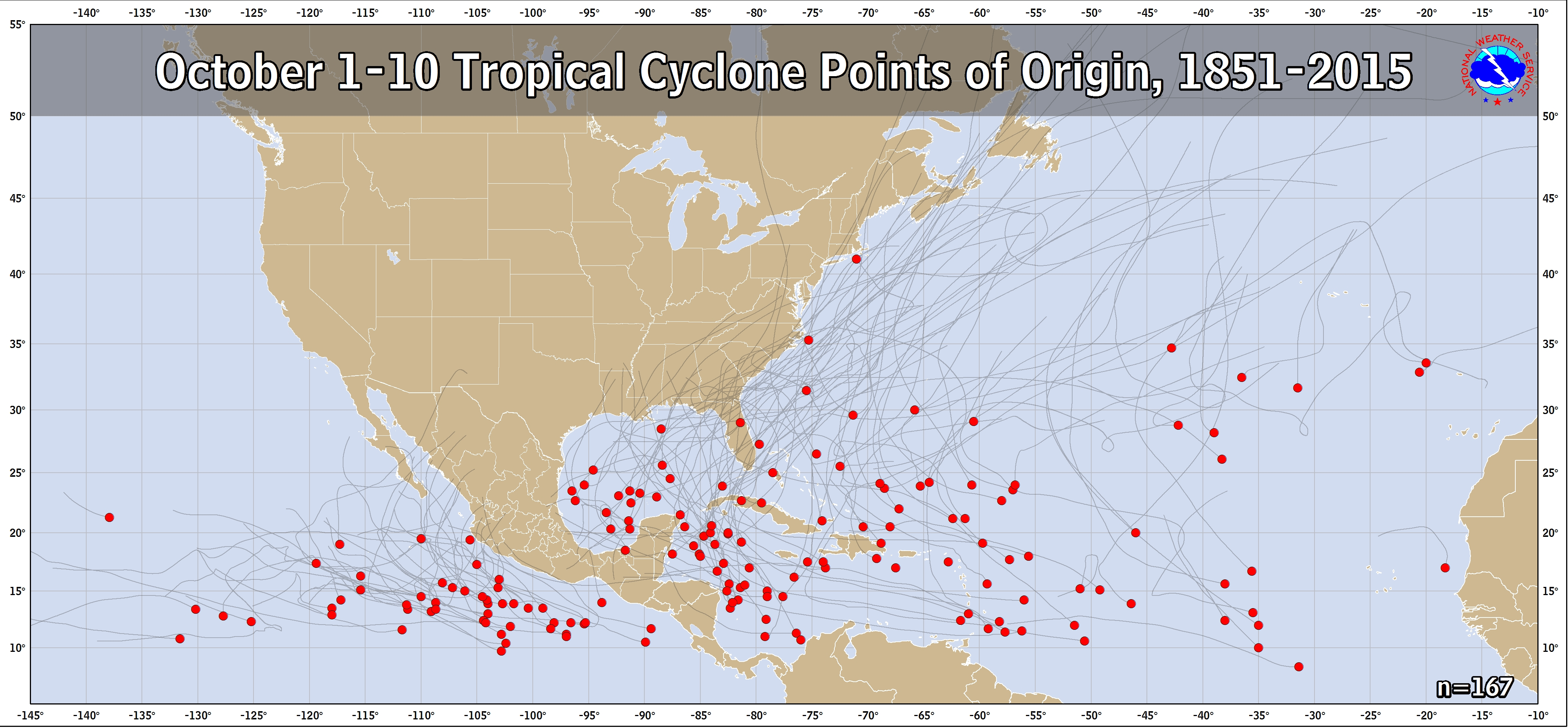
[quote="stormlover2013"]throw clima out right now, this is a weird pattern for early october its more like a august pattern with high pressure and etc[/quote
Just wondering how many "weird patterns" there have been in 160+ Octobers? This map doesn't show many.
Just wondering how many "weird patterns" there have been in 160+ Octobers? This map doesn't show many.
0 likes
Re: ATL: NATE - Tropical Storm - Discussion
stormlover2013 wrote:yeah track more towards la and away from florida.
The forecast has already shifted away from Florida. we've had the "Katrina shift" from Panama city to LA/MS. This is likely to be a right loaded system as it approaches so you're going to need a direct hit (or very close) or reside east of the landfall point for the action in all likelihood so portions of the panhandle will still be in line for some weather on its current projection. And of course the track remains subject to amendments since we're still a good way out. SE LA to western florida panhandle seems like the hot zone as of now.
0 likes
-
stormlover2013
Re: ATL: NATE - Models
it's early october, high pressure is pretty strong in Florida with what the models are showing, usually you have cold fronts that will keep systems away from la and they get pulled by trough or front towards Florida with a quick right hook.
1 likes
-
stormreader
Re: ATL: NATE - Models
gatorcane wrote:Stronger on 12Z GFS:
GFS looks like it shifted a tad further west. Give the models another couple of runs, but it looks like the La Coast is becoming more likely for landfall. GFS being stronger and with what Euro and HWRF are showing strength-wise, it would appear that La coastal residents should begin preparing for a hurricane landfall. Of course you can never rule out further east (especially with a late turn in October), but trends don't seem to be headed in that direction. Also, you have to prepare for at least a Cat 1. But with early October history, I think there is a very reasonable chance that we may see something stronger.
1 likes

Re: ATL: NATE - Tropical Storm - Discussion
Aric Dunn wrote:NDG wrote:Aric Dunn wrote:
huh?
nothing dying out about it.. and not rotating around anything.. so not sure what your saying. its also not just a little swirl.. its has become quite a bit more expansive overnight.
Is basically a naked swirl now, I remember last night it was tracking WNW if not NW while this morning is heading more WSW.
yes convection is limited. though the pressures continued to drop and the pressure field expanded and the circulation is much larger.. that is very important when it comes to nate..
You seem to be the only one talking about this but I'm absolutely intrigued. If it continues to interact with this wave, what;s the end play here? A harder turn NNE?
0 likes
Personal Forecast Disclaimer:
The posts in this forum are NOT official forecast and should not be used as such. They are just the opinion of the poster and may or may not be backed by sound meteorological data. They are NOT endorsed by any professional institution or storm2k.org. For official information, please refer to the NHC and NWS products.
The posts in this forum are NOT official forecast and should not be used as such. They are just the opinion of the poster and may or may not be backed by sound meteorological data. They are NOT endorsed by any professional institution or storm2k.org. For official information, please refer to the NHC and NWS products.
Re: ATL: NATE - Models
stormlover2013 wrote:it's early october, high pressure is pretty strong in Florida with what the models are showing, usually you have cold fronts that will keep systems away from la and they get pulled by trough or front towards Florida with a quick right hook.
Hurricane strikes in early October on the north central Gulf are not that rare. They are rare for Texas. A Louisiana landfall wouldn't be a huge shocker from a climo perspective
2 likes
Re: ATL: NATE - Models
HMON(70kts) and the HWRF(77kts) are back to a higher intensity about by the time it makes it to the NGOM just doe not bode will for the 10K cruisers on the MGC this week that's roughly 30K extra people here.Totally livable at that strength thought I saw 100kts a few moments ago so for the edit.
https://www.tropicaltidbits.com/analysi ... 0&ypos=228
https://www.tropicaltidbits.com/analysi ... 0&ypos=114
Nam looks like a decent cane but take with a grain of salt same area
https://www.tropicaltidbits.com/analysi ... s=0&ypos=0
https://www.tropicaltidbits.com/analysi ... 0&ypos=228
https://www.tropicaltidbits.com/analysi ... 0&ypos=114
Nam looks like a decent cane but take with a grain of salt same area
https://www.tropicaltidbits.com/analysi ... s=0&ypos=0
1 likes
-
tolakram
- Admin

- Posts: 20179
- Age: 62
- Joined: Sun Aug 27, 2006 8:23 pm
- Location: Florence, KY (name is Mark)
Re: ATL: NATE - Models
12Z GFS

0 likes
M a r k
- - - - -
Join us in chat: Storm2K Chatroom Invite. Android and IOS apps also available.
The posts in this forum are NOT official forecasts and should not be used as such. Posts are NOT endorsed by any professional institution or STORM2K.org. For official information and forecasts, please refer to NHC and NWS products.
-
SunnyThoughts
- Category 5
- Posts: 2263
- Joined: Wed Jul 09, 2003 12:42 pm
- Location: Pensacola, Florida
Re: ATL: NATE - Tropical Storm - Discussion
G-IV mission leaving in about an hour. Will be helpful as usual to have the info they gather ingested into the models.
1 likes

Re: ATL: NATE - Tropical Storm - Discussion
Baton Rouge met Steve Caparotta is really emphasizing this part of the 11am NHC Discussion on FB live feed.
The center of Nate is now inland over northeastern Nicaragua, and
little change in strength is expected until the center moves over
the northwestern Caribbean Sea. After that, a combination of warm
sea surface temperatures and light shear should allow for at least
steady strengthening. However, the guidance is producing mixed
signals despite a favorable-looking environment. The Rapid
Intensification Index of the SHIPS model is showing high chances of
rapid intensification, with better than a 50 percent chance of 25
kt of strengthening in the next 24 h and nearly a 50 percent chance
of 65 kt of strengthening in 72 h. On the other side, the GFS and
Canadian models show only modest development and keep the cyclone
as a tropical storm until it reaches the northern Gulf coast.
Given the environment, the intensity forecast leans towards the high
end of the guidance envelope and calls for Nate to become a
hurricane in about 48 h and reach the northern Gulf Coast as a
hurricane.
http://www.nhc.noaa.gov/text/refresh/MI ... 1447.shtml
0 likes
Re: ATL: NATE - Models
stormlover2013 wrote:jav thats the 06 runs
06 on the HWRF( 12z running now) and the 06Z on HMON which was faster and a shift of about 100miles E to the boot of LA/MGC.The HMON on that run lowered it's intensity compared to the 06 I would suspect to the quicker movement .I think once Nate gets N of Nic we will see a better view of intensity after 12-24hrs in that region.
Stand corrected both 06 models.
Last edited by Javlin on Thu Oct 05, 2017 11:35 am, edited 1 time in total.
0 likes
Who is online
Users browsing this forum: No registered users and 35 guests