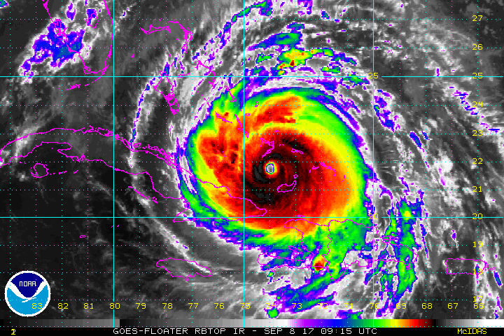
ATL: IRMA - Post-Tropical - Discussion

Moderator: S2k Moderators

Message
Author
HurrMark
Category 2
Category 2
Posts: 769
Joined: Tue Aug 12, 2008 10:18 pm
Location: Somerville, MA

Re: ATL: IRMA - Hurricane - Discussion

#7901 Postby HurrMark » Fri Sep 08, 2017 11:39 am

Langinbang187 wrote:
SoupBone wrote:
Langinbang187 wrote:Dr. M seems to find it unlikely Irma will ever regain Cat 5 intensity. He mentions it could even potentially weaken to a 3 from interaction with Cuba. At least a bit of good news there, as he was expecting Irma to ramp back up to 185 MPH Yesterday.


Link to this? If true and you're looking for at least something better, this is about all we're going to hear at this point. I really hope this holds true, but even a Cat 3 can be catastrophic in terms of damage and storm surge.


https://www.wunderground.com/cat6/extremely-dangerous-cat-4-irma-headed-florida

He even says there's a 20% chance it could weaken to a 2.


Agree with him...after we saw with Ike, which was only over Cuba 6 hours, it was unable to ever recover, even though it had the whole Gulf to work with. I do not expect this to get any stronger than it is now.
1 likes   

Aric Dunn
Category 5
Category 5
Posts: 21238
Age: 42
Joined: Sun Sep 19, 2004 9:58 pm
Location: Ready for the Chase.
Contact:

Re: ATL: IRMA - Hurricane - Discussion

#7902 Postby Aric Dunn » Fri Sep 08, 2017 11:39 am

outer eyewall convection finally reaching up through the CDO noce solid ring of cold cloud tops developing.. by 5pm we should have a very large clear eye..

IR channel 4

https://weather.msfc.nasa.gov/goes/abi/ ... and14.html
Last edited by Aric Dunn on Fri Sep 08, 2017 11:40 am, edited 1 time in total.
3 likes   
Note: If I make a post that is brief. Please refer back to previous posts for the analysis or reasoning. I do not re-write/qoute what my initial post said each time.
If there is nothing before... then just ask :)

Space & Atmospheric Physicist, Embry-Riddle Aeronautical University,
I believe the sky is falling...

boxwes
Tropical Low
Tropical Low
Posts: 12
Joined: Thu Sep 09, 2004 4:05 pm

Re: ATL: IRMA - Hurricane - Discussion

#7903 Postby boxwes » Fri Sep 08, 2017 11:39 am

KC7NEC wrote:Urgent, Please share this with those in Irma's path:

Anyone in the path of this Hurricane needs to download the "Firechat App" on iPhone and Android. The app is a messaging and communications tool that DOES NOT require a cellular connection. It works by creating a Bluetooth store-and-forward mesh network. The important thing to note is the more users with the app active in the area the better a message can travel out to reach a network connection. This could be a vital way to get messages out if the cell network is unusable.

For information or links to the app download visit: https://www.opengarden.com/firechat.html


Firechat's max range is 30-40 feet. It is only useful in highly dense urban areas.
1 likes   

jdjaguar
Category 2
Category 2
Posts: 551
Joined: Fri Aug 26, 2005 12:07 pm
Location: Jacksonville Beach, FL

Re: ATL: IRMA - Hurricane - Discussion

#7904 Postby jdjaguar » Fri Sep 08, 2017 11:41 am

Hurricane Andrew wrote:
stormreader wrote:
petit_bois wrote:
I wonder if Irma is going onshore of Cuba and struggles to get off the coast for 12-20 hrs. this could possible take her down to Cat 2 or weaker. Hopefully not to recover. Weaker storms tend to move more westerly as well. Possible good news for Miami, not so good for Cuba. Prayers for all involved.

Very quickly tuning in. Is that an NHC forecast for a possible landfall at about 165mph?

No sir, that is my personal forecast. Current NHC forecast, and remember that they have so many more worlds of skill than me, calls for a 145mph landfall. They are the experts, not me. Please remember that.

Impressive analysis, however so impressive it appears at first glance to be from the NHC.
Might be helpful to put at the top in all caps PERSONAL FORECAST
1 likes   

User avatar
Steve
S2K Supporter
S2K Supporter
Posts: 9623
Joined: Sat Apr 05, 2003 11:41 pm
Location: Not a state-caster

Re: ATL: IRMA - Hurricane - Discussion

#7905 Postby Steve » Fri Sep 08, 2017 11:41 am

Agreed norva. He's got to present all the possibilities, and I understand that. There is a chance it could hit as a 2, but it would have had to have been massively disrupted by Cuba or mystery forces for that to happen. Likely a 5 south of Florida if it doesn't spend too much time over Cuba and probably coming in at a medium-high end Cat 4. FWIW, UKMET which has insisted on Cuba all along has dropped that on the 12Z run. Meanwhile, HMON (GFDL's replacement) now does spend time on the Northern Cuban Coast.
2 likes   

wicked_wx_watcher
Tropical Depression
Tropical Depression
Posts: 53
Joined: Sat Jan 13, 2007 12:56 pm
Location: Clear Lake City/Webster, TX

Re: ATL: IRMA - Hurricane - Discussion

#7906 Postby wicked_wx_watcher » Fri Sep 08, 2017 11:45 am

It looks like Irma is hell bent on entering the gulf. If storm intensifies, can it continue a more westerly track for a longer period of time?
1 likes   
Texas Strong - Come Hell or High Water

Alicia 1983 Bonnie 1986 TS Allison (1) 1989 Chantal 1989 Jerry 1989 TS Allison (2) 2001 Rita 2005 Humberto 2007
Ike 2008 Harvey 2017 Beryl 2024

Dave C
S2K Supporter
S2K Supporter
Posts: 868
Joined: Thu Sep 04, 2003 4:36 pm
Location: Middleboro, Mass.(midway between Cape Cod and Boston)

Re: ATL: IRMA - Hurricane - Discussion

#7907 Postby Dave C » Fri Sep 08, 2017 11:46 am

Aric Dunn wrote:outer eyewall convection finally reaching up through the CDO noce solid ring of cold cloud tops developing.. by 5pm we should have a very large clear eye..

IR channel 4

https://weather.msfc.nasa.gov/goes/abi/ ... and14.html

Cuba radar shows that little chunk of inner eyewall rotating around but outer eyewall looks real impressive with multiple feeder bands feeding it from the south.
1 likes   

User avatar
GCANE
S2K Supporter
S2K Supporter
Posts: 11502
Joined: Mon Oct 22, 2007 8:03 am

Re: ATL: IRMA - Hurricane - Discussion

#7908 Postby GCANE » Fri Sep 08, 2017 11:46 am

0 likes   

User avatar
Ntxw
Storm2k Moderator
Storm2k Moderator
Posts: 22790
Joined: Wed Oct 21, 2009 6:34 pm
Location: DFW, Texas

Re: ATL: IRMA - Hurricane - Discussion

#7909 Postby Ntxw » Fri Sep 08, 2017 11:47 am

Important!!!

Due to the sensitivity and dangers of the situation if you are making a prediction that is NOT an NHC or NWS forecast please note the source or if it is personal opinion to avoid confusion. To all readers it is advised to look to your state and local authorities for accurate information as well as the NHC first.
6 likes   
The above post and any post by Ntxw is NOT an official forecast and should not be used as such. It is just the opinion of the poster and may or may not be backed by sound meteorological data. It is NOT endorsed by any professional institution including Storm2k. For official information, please refer to NWS products.

  Help support Storm2K!
Help Support Storm2K

tolakram
Admin
Admin
Posts: 20012
Age: 62
Joined: Sun Aug 27, 2006 8:23 pm
Location: Florence, KY (name is Mark)

Re: ATL: IRMA - Hurricane - Discussion

#7910 Postby tolakram » Fri Sep 08, 2017 11:47 am

Please report posts instead of replying to them.
3 likes   
M a r k
- - - - -
Join us in chat: Storm2K Chatroom Invite. Android and IOS apps also available.

The posts in this forum are NOT official forecasts and should not be used as such. Posts are NOT endorsed by any professional institution or STORM2K.org. For official information and forecasts, please refer to NHC and NWS products.

Patrick99
Category 5
Category 5
Posts: 1772
Joined: Mon May 24, 2004 3:43 pm
Location: SW Broward, FL

Re: ATL: IRMA - Hurricane - Discussion

#7911 Postby Patrick99 » Fri Sep 08, 2017 11:50 am

Think Cuba is having a significant effect on Irma even if it isn't making landfall yet. Cloud tops have warmed further and the eye looks ragged. Keep it up I say
2 likes   

User avatar
Extratropical94
Professional-Met
Professional-Met
Posts: 3538
Age: 30
Joined: Wed Oct 20, 2010 6:36 am
Location: Hamburg, Germany
Contact:

Re: ATL: IRMA - Hurricane - Discussion

#7912 Postby Extratropical94 » Fri Sep 08, 2017 11:51 am

GCANE wrote:https://twitter.com/1WTFNews/status/906196650007384065


Good thing they waived fees on the turnpike and other toll roads to avoid creating even larger backups at the toll stations.
2 likes   
54° 11' 59'' N, 9° 9' 20'' E
Boomer Sooner!
Go Broncos! Go Cards! Go Niners!
- Daniel

KC7NEC
Tropical Storm
Tropical Storm
Posts: 162
Joined: Wed Oct 05, 2016 12:01 am

Re: ATL: IRMA - Hurricane - Discussion

#7913 Postby KC7NEC » Fri Sep 08, 2017 11:52 am

boxwes wrote:
KC7NEC wrote:Urgent, Please share this with those in Irma's path:

Anyone in the path of this Hurricane needs to download the "Firechat App" on iPhone and Android. The app is a messaging and communications tool that DOES NOT require a cellular connection. It works by creating a Bluetooth store-and-forward mesh network. The important thing to note is the more users with the app active in the area the better a message can travel out to reach a network connection. This could be a vital way to get messages out if the cell network is unusable.

For information or links to the app download visit: https://www.opengarden.com/firechat.html


Firechat's max range is 30-40 feet. It is only useful in highly dense urban areas.


Not completely accurate. If your message is not sent it is stored until it gets a connection. Yes, each connection is maybe 40" but once a connection is made it is stored on the receiving device until it makes a connection. There is a very long article online of it being used in major disaasters.

We tested monitoring of it in Oregon during the Eclipse as part of our emergency management work and were able to get messages from areas with zero cell service for miles. This included information on a major car accident that had backed up traffic on a highway. The message had "bounced" from car to car down the highway until a hit user in town 35 miles away with service and was delivered to the State EOC 100 miles away via a network.

It may not be instant communications but it does work and will get a message through.
2 likes   
// Opinions are my own, I am not a Meteorologist. Consult the NHC or Local NWS and Emergency Management for current information in your area. //

Langinbang187

Re: ATL: IRMA - Hurricane - Discussion

#7914 Postby Langinbang187 » Fri Sep 08, 2017 11:53 am

Irma's starting to look pretty rough.
0 likes   

User avatar
Meteorcane
Category 2
Category 2
Posts: 559
Joined: Thu Jul 21, 2011 6:49 am
Location: North Platte Nebraska

Re: ATL: IRMA - Hurricane - Discussion

#7915 Postby Meteorcane » Fri Sep 08, 2017 11:53 am

Patrick99 wrote:Think Cuba is having a significant effect on Irma even if it isn't making landfall yet. Cloud tops have warmed further and the eye looks ragged. Keep it up I say


Not seeing cloud tops warming at all on the 30 second 10.35micron channel, if anything they are cooling.
0 likes   

User avatar
meriland29
Category 2
Category 2
Posts: 770
Joined: Thu Aug 03, 2017 11:05 am

Re: ATL: IRMA - Hurricane - Discussion

#7916 Postby meriland29 » Fri Sep 08, 2017 11:53 am

What's going on with her EW right now?
0 likes   

User avatar
GCANE
S2K Supporter
S2K Supporter
Posts: 11502
Joined: Mon Oct 22, 2007 8:03 am

Re: ATL: IRMA - Hurricane - Discussion

#7917 Postby GCANE » Fri Sep 08, 2017 11:55 am

Looking at SREF, thankfully not seeing any significant tornado threat. Remaining mostly off shore.

Image
1 likes   

Langinbang187

Re: ATL: IRMA - Hurricane - Discussion

#7918 Postby Langinbang187 » Fri Sep 08, 2017 11:57 am

Image

Cloud tops are really warming now. Cuba already effecting her?
1 likes   

AutoPenalti
Category 5
Category 5
Posts: 4030
Age: 29
Joined: Mon Aug 17, 2015 4:16 pm
Location: Ft. Lauderdale, Florida

Re: ATL: IRMA - Hurricane - Discussion

#7919 Postby AutoPenalti » Fri Sep 08, 2017 11:59 am

Irma being hit hard right now. At least that's good news for us but terrible for Cuba.
0 likes   
The posts in this forum are NOT official forecasts and should not be used as such. They are just the opinion of the poster and may or may not be backed by sound meteorological data. They are NOT endorsed by any professional institution or STORM2K. For official information, please refer to products from the NHC and NWS.


Model Runs Cheat Sheet:
GFS (5:30 AM/PM, 11:30 AM/PM)
HWRF, GFDL, UKMET, NAVGEM (6:30-8:00 AM/PM, 12:30-2:00 AM/PM)
ECMWF (1:45 AM/PM)

TCVN
is a weighted averaged

Hurricane_Apu
Tropical Storm
Tropical Storm
Posts: 124
Joined: Tue Aug 31, 2004 5:47 pm

Re: ATL: IRMA - Hurricane - Discussion

#7920 Postby Hurricane_Apu » Fri Sep 08, 2017 12:00 pm

Remember that we're near peak daytime solar radiation/heating and cloud tops will be warming even absent any other cause.
2 likes   


Return to “2017”

Who is online

Users browsing this forum: No registered users and 1 guest