ATL: INVEST 98L - Discussion
Moderator: S2k Moderators
-
EquusStorm
- Category 5

- Posts: 1649
- Age: 35
- Joined: Thu Nov 07, 2013 1:04 pm
- Location: Jasper, AL
- Contact:
Re: ATL: INVEST 98L - Discussion
And with low clouds streaming in from seemingly every direction on the compass, I kind of wish slightly less emphasis would be placed on scatterometer data in favor of satellite indications. Maybe I'm wrong on that but the low and mid level clouds really do make it look very nearly closed.
1 likes
Colors of lost purpose on the canvas of irrelevance
Not a meteorologist, in fact more of an idiot than anything. You should probably check with the NHC or a local NWS office for official information.
Not a meteorologist, in fact more of an idiot than anything. You should probably check with the NHC or a local NWS office for official information.
-
Aric Dunn
- Category 5
- Posts: 21238
- Age: 43
- Joined: Sun Sep 19, 2004 9:58 pm
- Location: Ready for the Chase.
- Contact:
Re: ATL: INVEST 98L - Discussion
EquusStorm wrote:And with low clouds streaming in from seemingly every direction on the compass, I kind of wish slightly less emphasis would be placed on scatterometer data in favor of satellite indications. Maybe I'm wrong on that but the low and mid level clouds really do make it look very nearly closed.
the scatt data is very helpful to a point. but under certain circumstances where there are known issues then yes take the scatt data and use satellite to fill in the gaps.
1 likes
Note: If I make a post that is brief. Please refer back to previous posts for the analysis or reasoning. I do not re-write/qoute what my initial post said each time.
If there is nothing before... then just ask
Space & Atmospheric Physicist, Embry-Riddle Aeronautical University,
I believe the sky is falling...
If there is nothing before... then just ask
Space & Atmospheric Physicist, Embry-Riddle Aeronautical University,
I believe the sky is falling...

Re: ATL: INVEST 98L - Discussion
Aric Dunn wrote:EquusStorm wrote:And with low clouds streaming in from seemingly every direction on the compass, I kind of wish slightly less emphasis would be placed on scatterometer data in favor of satellite indications. Maybe I'm wrong on that but the low and mid level clouds really do make it look very nearly closed.
the scatt data is very helpful to a point. but under certain circumstances where there are known issues then yes take the scatt data and use satellite to fill in the gaps.
Correct me if I'm wrong, but don't the scatterometers measure seafoam or something?
Given the resolution, along with the fairly small size and fast movement, it's entirely likely that it did in fact miss the full wind motion as (similar with the models and smaller systems) it can't fully resolve it. Either way it's in my unofficial book as a 40kt subtropical storm.
1 likes
The above post is not official and should not be used as such. It is the opinion of the poster and may or may not be backed by sound meteorological data. It is not endorsed by any professional institution or storm2k.org. For official information, please refer to the NHC and NWS products.
-
Monsoonjr99
- Tropical Storm

- Posts: 210
- Age: 26
- Joined: Fri Sep 21, 2018 11:22 pm
- Location: Inland Empire, SoCal
Re: ATL: INVEST 98L - Discussion
Florence's TCR might be interesting...
0 likes
The posts in this forum are NOT official forecasts and should not be used as such. They are just the opinion of the poster and may or may not be backed by sound meteorological data. They are NOT endorsed by any professional institution or STORM2K. For official information, please refer to products from the NHC and NWS.
Some Californian who codes things and tracks weather.
Kay '22, Hilary '23

Re: ATL: INVEST 98L - Discussion
Monsoonjr99 wrote:Florence's TCR might be interesting...
What does that have to do with 98L? If you are suggesting that Florence's TCR might show Florence regenerating, since this is not part of the main system of Florence, it would have its own TCR as "Unnamed Tropical Storm"
0 likes
Kendall -> SLO -> PBC
Memorable Storms: Katrina (for its Florida landfall...) Wilma Matthew Irma
Memorable Storms: Katrina (for its Florida landfall...) Wilma Matthew Irma
-
cycloneye

- Admin

- Posts: 148890
- Age: 69
- Joined: Thu Oct 10, 2002 10:54 am
- Location: San Juan, Puerto Rico
Re: ATL: INVEST 98L - Discussion
Shower activity has changed little in organization near an area of
disturbed weather located about 300 miles south-southwest of
Halifax, Nova Scotia. This system is expected to merge with a
frontal system and move north-northeastward over increasingly colder
waters overnight, and no additional development is forecast. For
more information on this system, see High Seas Forecasts issued by
the National Weather Service.
* Formation chance through 48 hours...low...near 0 percent.
* Formation chance through 5 days...low...near 0 percent.
0 likes
Visit the Caribbean-Central America Weather Thread where you can find at first post web cams,radars
and observations from Caribbean basin members Click Here
and observations from Caribbean basin members Click Here
-
EquusStorm
- Category 5
- Posts: 1649
- Age: 35
- Joined: Thu Nov 07, 2013 1:04 pm
- Location: Jasper, AL
- Contact:
Re: ATL: INVEST 98L - Discussion
0 likes
Colors of lost purpose on the canvas of irrelevance
Not a meteorologist, in fact more of an idiot than anything. You should probably check with the NHC or a local NWS office for official information.
Not a meteorologist, in fact more of an idiot than anything. You should probably check with the NHC or a local NWS office for official information.
Re: ATL: INVEST 98L - Discussion
Looks like it did have a closed circ. Almost certain we'll see an unnamed TS/STS in this year's TCR
1 likes
Kendall -> SLO -> PBC
Memorable Storms: Katrina (for its Florida landfall...) Wilma Matthew Irma
Memorable Storms: Katrina (for its Florida landfall...) Wilma Matthew Irma
-
EquusStorm
- Category 5
- Posts: 1649
- Age: 35
- Joined: Thu Nov 07, 2013 1:04 pm
- Location: Jasper, AL
- Contact:
Re: ATL: INVEST 98L - Discussion
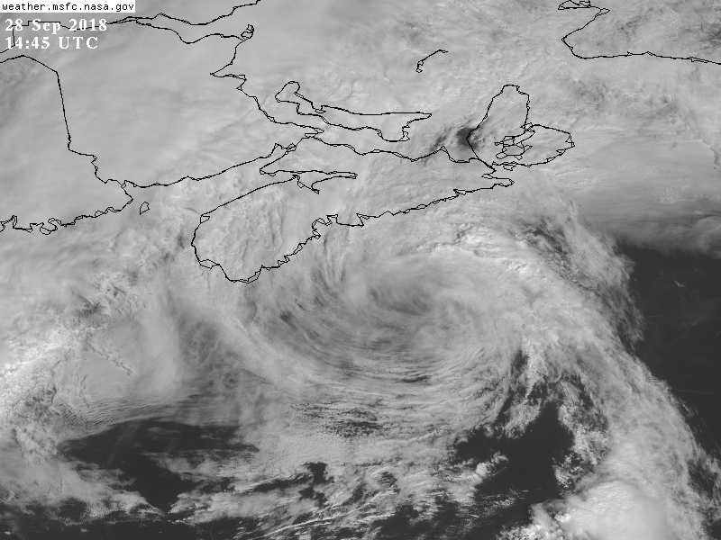
I'd like to think so. Hope they really look into it closely. The loop really does remind one of a closed surface remnant low.
Here's a better one. Definitely closed at THIS point, but a mere remnant
Here's a better one. Definitely closed at THIS point, but a mere remnant
0 likes
Colors of lost purpose on the canvas of irrelevance
Not a meteorologist, in fact more of an idiot than anything. You should probably check with the NHC or a local NWS office for official information.
Not a meteorologist, in fact more of an idiot than anything. You should probably check with the NHC or a local NWS office for official information.
Who is online
Users browsing this forum: No registered users and 44 guests