ATL: CHRIS - Post-Tropical
Moderator: S2k Moderators
-
CrazyC83
- Professional-Met

- Posts: 34315
- Joined: Tue Mar 07, 2006 11:57 pm
- Location: Deep South, for the first time!
Re: ATL: THREE - Tropical Depression - Discussion
I think the environmental pressure is like 1025. 1000mb in this environment would likely be a hurricane.
2 likes
Re: ATL: THREE - Models
UKMET shifts nearly into Maine
VERIFYING TIME TIME POSITION PRESSURE (MB) SPEED (KNOTS)
-------------- ---- -------- ------------- -------------
1200UTC 07.07.2018 0 32.9N 74.8W 1015 30
0000UTC 08.07.2018 12 33.0N 75.0W 1013 33
1200UTC 08.07.2018 24 33.0N 75.0W 1012 31
0000UTC 09.07.2018 36 32.9N 74.3W 1006 41
1200UTC 09.07.2018 48 33.1N 74.6W 1003 40
0000UTC 10.07.2018 60 33.1N 75.4W 997 41
1200UTC 10.07.2018 72 33.0N 75.7W 992 59
0000UTC 11.07.2018 84 33.1N 75.2W 982 58
1200UTC 11.07.2018 96 34.2N 73.6W 966 74
0000UTC 12.07.2018 108 36.4N 70.3W 960 75
1200UTC 12.07.2018 120 39.7N 67.9W 956 70
0000UTC 13.07.2018 132 42.6N 66.6W 977 54
1200UTC 13.07.2018 144 45.3N 65.6W 1001 35
0 likes
-
cycloneye

- Admin

- Posts: 149368
- Age: 69
- Joined: Thu Oct 10, 2002 10:54 am
- Location: San Juan, Puerto Rico
Re: ATL: THREE - Recon

0 likes
Visit the Caribbean-Central America Weather Thread where you can find at first post web cams,radars
and observations from Caribbean basin members Click Here
and observations from Caribbean basin members Click Here
-
cycloneye
- Admin
- Posts: 149368
- Age: 69
- Joined: Thu Oct 10, 2002 10:54 am
- Location: San Juan, Puerto Rico
Re: ATL: THREE - Tropical Depression - Discussion
@pppapin
Recon flying into #TD3 is interesting so far. A broad and defuse center w/ perhaps an attempt of a center reformation further into the deep convection around 32.5N/75.5W with the lowest pressure (1014-hPa). SFMR winds of 41kt & FL winds of 35kt close to #TS intensity.
Recon flying into #TD3 is interesting so far. A broad and defuse center w/ perhaps an attempt of a center reformation further into the deep convection around 32.5N/75.5W with the lowest pressure (1014-hPa). SFMR winds of 41kt & FL winds of 35kt close to #TS intensity.
0 likes
Visit the Caribbean-Central America Weather Thread where you can find at first post web cams,radars
and observations from Caribbean basin members Click Here
and observations from Caribbean basin members Click Here
-
cycloneye
- Admin
- Posts: 149368
- Age: 69
- Joined: Thu Oct 10, 2002 10:54 am
- Location: San Juan, Puerto Rico
Re: ATL: THREE - Recon
Mission is over as plane is acending.
000
URNT15 KNHC 071710
AF306 0103A CYCLONE HDOB 34 20180707
170100 3138N 07700W 6989 03197 //// +074 //// 324011 014 022 000 01
170130 3138N 07702W 6751 03483 //// +062 //// 325010 011 021 000 01
170200 3138N 07704W 6517 03773 //// +044 //// 342014 016 021 000 01
170230 3138N 07706W 6295 04056 //// +025 //// 347014 016 021 000 01
170300 3138N 07708W 6076 04342 //// +009 //// 339013 014 022 000 01
170330 3138N 07710W 5878 04610 //// -007 //// 342011 012 021 000 01
170400 3138N 07712W 5732 04820 //// -022 //// 344011 011 020 000 01
170430 3138N 07714W 5709 04857 //// -021 //// 342010 011 020 000 01
170500 3138N 07717W 5619 04969 //// -027 //// 335009 009 022 000 01
170530 3138N 07719W 5421 05255 0287 -041 //// 332010 010 021 000 01
170600 3138N 07721W 5253 05503 0300 -047 //// 336010 011 022 000 01
170630 3138N 07723W 5090 05761 0319 -060 //// 328009 009 021 000 01
170700 3138N 07725W 4998 05906 0328 -071 //// 330010 011 021 000 01
170730 3138N 07727W 4865 06115 0339 -083 //// 320011 012 021 000 01
170800 3138N 07729W 4761 06283 0349 -091 //// 307009 009 020 000 01
170830 3138N 07731W 4652 06461 0361 -101 //// 305008 009 020 000 01
170900 3138N 07733W 4557 06625 0373 -113 //// 307007 008 020 000 01
170930 3138N 07735W 4470 06769 0381 -122 //// 301008 008 020 000 01
171000 3138N 07737W 4387 06916 0389 -132 //// 297008 008 020 000 01
171030 3138N 07740W 4303 07062 0397 -142 //// 289008 008 020 000 01
$$
0 likes
Visit the Caribbean-Central America Weather Thread where you can find at first post web cams,radars
and observations from Caribbean basin members Click Here
and observations from Caribbean basin members Click Here
-
cycloneye
- Admin
- Posts: 149368
- Age: 69
- Joined: Thu Oct 10, 2002 10:54 am
- Location: San Juan, Puerto Rico
Re: ATL: THREE - Recon
Next mission will depart at 11 PM EDT tonight.
FLIGHT TWO - TEAL 72
A. 08/0600Z
B. AFXXX 0203A CYCLONE
C. 08/0300Z
D. 33.5N 74.5W
E. 08/0530Z TO 08/0900Z
F. SFC TO 10,000 FT
FLIGHT TWO - TEAL 72
A. 08/0600Z
B. AFXXX 0203A CYCLONE
C. 08/0300Z
D. 33.5N 74.5W
E. 08/0530Z TO 08/0900Z
F. SFC TO 10,000 FT
0 likes
Visit the Caribbean-Central America Weather Thread where you can find at first post web cams,radars
and observations from Caribbean basin members Click Here
and observations from Caribbean basin members Click Here
-
seahawkjd
- S2K Supporter

- Posts: 632
- Joined: Wed Sep 10, 2003 4:12 pm
- Location: Morehead City, NC
- Contact:
Re: ATL: THREE - Tropical Depression - Discussion
So a relocation more to the West? I'm guessing we're going to have a rainy couple of days.
0 likes
Gloria, Hugo, Emily, Bertha, Bonnie, Dennis (twice), Fran, Floyd, Isabel, Irene, Arthur, Matthew, Florence, Dorian (and many tropical storms and nor'easters).
-
cycloneye
- Admin
- Posts: 149368
- Age: 69
- Joined: Thu Oct 10, 2002 10:54 am
- Location: San Juan, Puerto Rico
Re: ATL: THREE - Tropical Depression - Discussion
TXNT27 KNES 071814
TCSNTL
A. 03L (NONAME)
B. 07/1745Z
C. 32.6N
D. 75.3W
E. THREE/GOES-E
F. T2.0/2.0/D0.5/24HRS
G. IR/EIR/VIS
H. REMARKS...SHEARED PATTERN WITH CIRCULARLY DEFINED CLOUD LINES
AND A CENTER VERY CLOSE TO A LARGE AREA OF CONVECTION YIELDS A DT OF
2.0. MET=2.5 AND PT=2.0. FT IS BASED ON DT.
I. ADDL POSITIONS
NIL
...KIM
0 likes
Visit the Caribbean-Central America Weather Thread where you can find at first post web cams,radars
and observations from Caribbean basin members Click Here
and observations from Caribbean basin members Click Here
-
cycloneye
- Admin
- Posts: 149368
- Age: 69
- Joined: Thu Oct 10, 2002 10:54 am
- Location: San Juan, Puerto Rico
Re: ATL: THREE - Recon
NIce to see new things added to the VDM.
@EricBlake12
A little history this morning as the first operational vortex message in the new recon format was transmitted- I was the head of the team to modernize the message, so it is quite satisfying to see it complete! #TD3
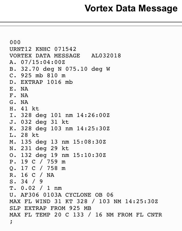
https://twitter.com/EricBlake12/status/1015631291881082881
@EricBlake12
A little history this morning as the first operational vortex message in the new recon format was transmitted- I was the head of the team to modernize the message, so it is quite satisfying to see it complete! #TD3
https://twitter.com/EricBlake12/status/1015631291881082881
0 likes
Visit the Caribbean-Central America Weather Thread where you can find at first post web cams,radars
and observations from Caribbean basin members Click Here
and observations from Caribbean basin members Click Here

Re: ATL: THREE - Tropical Depression - Discussion
Latest hot towers are a little displaced from the center, but the low pressure is over the Gulf Stream so this should have time to make Hurricane status before moving over cooler waters.
0 likes
-
cycloneye
- Admin
- Posts: 149368
- Age: 69
- Joined: Thu Oct 10, 2002 10:54 am
- Location: San Juan, Puerto Rico
Re: ATL: THREE - Advisories
BULLETIN
Tropical Depression Three Advisory Number 5
NWS National Hurricane Center Miami FL AL032018
500 PM EDT Sat Jul 07 2018
...TROPICAL DEPRESSION FORECAST TO BECOME A TROPICAL STORM
TONIGHT OR SUNDAY...
...LITTLE MOVEMENT IS ANTICIPATED...
SUMMARY OF 500 PM EDT...2100 UTC...INFORMATION
----------------------------------------------
LOCATION...32.9N 75.3W
ABOUT 160 MI...255 KM S OF CAPE HATTERAS NORTH CAROLINA
MAXIMUM SUSTAINED WINDS...35 MPH...55 KM/H
PRESENT MOVEMENT...STATIONARY
MINIMUM CENTRAL PRESSURE...1014 MB...29.95 INCHES
Tropical Depression Three Discussion Number 5
NWS National Hurricane Center Miami FL AL032018
500 PM EDT Sat Jul 07 2018
An Air Force reconnaissance aircraft investigated the depression a
few hours ago and found that the circulation is still somewhat
elongated with a minimum pressure of 1015 mb. The plane measured
flight-level winds which support an initial intensity of
30 kt. These winds were confined to a convective band south of the
center. The satellite presentation has not improved very much since
the morning advisory. The cyclone will remain over warm waters and
in a relatively low-shear environment for the next 2 to 3 days.
Based on these conditions, the NHC forecast calls for gradual
strengthening, and the depression is expected to become a tropical
storm within the next 12 hours or so. Additional intensification
is anticipated when the cyclone moves toward the northeast over the
open Atlantic as indicated by most of the models. The cyclone will
most likely begin to acquire extratropical characteristics over
cold waters by the end of the forecast period.
The depression continues to be embedded within very weak steering
currents, and little motion is anticipated for the next 2 days.
After that time, the cyclone will be steered toward the northeast
with increasing forward speed within the southwesterly flow ahead of
an approaching mid-level trough. Guidance continues to clearly
indicate the cyclone's slow drift during the next 2 days, and
unanimously forecast the cyclone to accelerate to the northeast
thereafter. The NHC forecast continues to be in the middle of the
guidance envelope, and very closely follows the multi-model
consensus.
Guidance continues to suggest that the cyclone will not approach
the coast and that the forecast tropical-storm-force winds
will not reach the U.S. coast. On this basis, no watches or warnings
are required at this time, however, interests along the North
Carolina coast should monitor the progress of the system.
FORECAST POSITIONS AND MAX WINDS
INIT 07/2100Z 32.9N 75.3W 30 KT 35 MPH
12H 08/0600Z 33.0N 75.3W 40 KT 45 MPH
24H 08/1800Z 33.0N 74.7W 45 KT 50 MPH
36H 09/0600Z 32.9N 74.1W 50 KT 60 MPH
48H 09/1800Z 33.0N 73.9W 55 KT 65 MPH
72H 10/1800Z 34.5N 71.5W 65 KT 75 MPH
96H 11/1800Z 40.0N 63.5W 60 KT 70 MPH
120H 12/1800Z 48.0N 54.0W 45 KT 50 MPH...POST-TROP/EXTRATROP
$$
Forecaster Avila
0 likes
Visit the Caribbean-Central America Weather Thread where you can find at first post web cams,radars
and observations from Caribbean basin members Click Here
and observations from Caribbean basin members Click Here
-
CyclonicFury

- Category 5

- Posts: 2032
- Age: 27
- Joined: Sun Jul 02, 2017 12:32 pm
- Location: NC
- Contact:
Re: ATL: THREE - Models
18z GFS is much stronger with this. Has it becoming a hurricane by Wednesday.
1 likes
NCSU B.S. in Meteorology Class of 2021. Tropical weather blogger at http://www.cyclonicfury.com. My forecasts and thoughts are NOT official, for official forecasts please consult the National Hurricane Center.
-
cycloneye
- Admin
- Posts: 149368
- Age: 69
- Joined: Thu Oct 10, 2002 10:54 am
- Location: San Juan, Puerto Rico
Re: ATL: THREE - Models
CyclonicFury wrote:18z GFS is much stronger with this. Has it becoming a hurricane by Wednesday.
Indeed.

0 likes
Visit the Caribbean-Central America Weather Thread where you can find at first post web cams,radars
and observations from Caribbean basin members Click Here
and observations from Caribbean basin members Click Here

Re: ATL: THREE - Tropical Depression - Discussion
Really coming together this afternoon, and if you watch closely on the hi-res NASA loop it almost appears the low clouds are speeding up near the end
1 likes
The above post is not official and should not be used as such. It is the opinion of the poster and may or may not be backed by sound meteorological data. It is not endorsed by any professional institution or storm2k.org. For official information, please refer to the NHC and NWS products.
-
seahawkjd
- S2K Supporter
- Posts: 632
- Joined: Wed Sep 10, 2003 4:12 pm
- Location: Morehead City, NC
- Contact:
Re: ATL: THREE - Tropical Depression - Discussion
Its pretty windy here on the coast of NC with gusts up to 40 mph and a couple of downpours.
1 likes
Gloria, Hugo, Emily, Bertha, Bonnie, Dennis (twice), Fran, Floyd, Isabel, Irene, Arthur, Matthew, Florence, Dorian (and many tropical storms and nor'easters).

Re: ATL: THREE - Tropical Depression - Discussion
Upgrade to TS at 11pm?
1 likes
Igor 2010, Sandy 2012, Fay 2014, Gonzalo 2014, Joaquin 2015, Nicole 2016, Humberto 2019, Imelda 2025
I am only a tropical weather enthusiast. My predictions are not official and may or may not be backed by sound meteorological data. For official information, please refer to the NHC and NWS products.
I am only a tropical weather enthusiast. My predictions are not official and may or may not be backed by sound meteorological data. For official information, please refer to the NHC and NWS products.
Re: ATL: THREE - Tropical Depression - Discussion
Kazmit wrote:Upgrade to TS at 11pm?
We should have an idea in the next 30 minutes when the BT comes out. Personally it looks at least 35kt at the moment if not close to 40kt.
1 likes
The above post is not official and should not be used as such. It is the opinion of the poster and may or may not be backed by sound meteorological data. It is not endorsed by any professional institution or storm2k.org. For official information, please refer to the NHC and NWS products.
-
cycloneye
- Admin
- Posts: 149368
- Age: 69
- Joined: Thu Oct 10, 2002 10:54 am
- Location: San Juan, Puerto Rico
Re: ATL: THREE - Tropical Depression - Discussion
Still TD.I think they will wait for the next overnight mission unless there is ASCAT that comes.
AL, 03, 2018070800, , BEST, 0, 328N, 751W, 30, 1014, TD
1 likes
Visit the Caribbean-Central America Weather Thread where you can find at first post web cams,radars
and observations from Caribbean basin members Click Here
and observations from Caribbean basin members Click Here
Re: ATL: THREE - Tropical Depression - Discussion
cycloneye wrote:Still TD.I think they will wait for the next overnight mission unless there is ASCAT that comes.AL, 03, 2018070800, , BEST, 0, 328N, 751W, 30, 1014, TD
Are we getting a 2am-ish flight?
0 likes
The above post is not official and should not be used as such. It is the opinion of the poster and may or may not be backed by sound meteorological data. It is not endorsed by any professional institution or storm2k.org. For official information, please refer to the NHC and NWS products.
-
cycloneye
- Admin
- Posts: 149368
- Age: 69
- Joined: Thu Oct 10, 2002 10:54 am
- Location: San Juan, Puerto Rico
Re: ATL: THREE - Tropical Depression - Discussion
Hammy wrote:cycloneye wrote:Still TD.I think they will wait for the next overnight mission unless there is ASCAT that comes.AL, 03, 2018070800, , BEST, 0, 328N, 751W, 30, 1014, TD
Are we getting a 2am-ish flight?
Plane departs at 11 PM EDT.
0 likes
Visit the Caribbean-Central America Weather Thread where you can find at first post web cams,radars
and observations from Caribbean basin members Click Here
and observations from Caribbean basin members Click Here
Who is online
Users browsing this forum: No registered users and 457 guests