CPAC: LANE - Post-Tropical

Moderator: S2k Moderators

Message
Author
User avatar
Yellow Evan
Professional-Met
Professional-Met
Posts: 16143
Age: 27
Joined: Fri Jul 15, 2011 12:48 pm
Location: Henderson, Nevada/Honolulu, HI
Contact:

Re: CPAC: LANE - Hurricane

#1001 Postby Yellow Evan » Tue Aug 21, 2018 7:13 pm

Got the Dvorak right too bad it's worthless right now.

TXPN41 PHFO 212355 CCA
TCSNP1

CENTRAL PACIFIC TROPICAL CYCLONE SUMMARY - FIXES
NWS CENTRAL PACIFIC HURRICANE CENTER HONOLULU HI
2353 UTC TUE AUG 21 2018

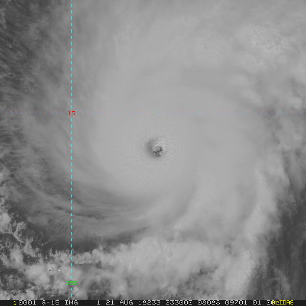
A. HURRICANE LANE EP142018.

B. 21/2330Z.

C. 14.4N.

D. 153.5W.

E. GOES-W.

F. T6.5/7.0/D0.5/24HRS.

G. VIS/IR/EIR.

H. Remarks: EYE PATTERN WITH WMG EYE AND SURROUNDING B RING, YIELDING A DATA T OF 6.5. MET AND PT ARE 6.5. FT BASED ON DATA T.

I. ADDL POSITIONS NONE.

$$

KINO.
0 likes   

User avatar
1900hurricane
Category 5
Category 5
Posts: 6059
Age: 34
Joined: Fri Feb 06, 2015 12:04 pm
Location: Houston, TX
Contact:

Re: CPAC: LANE - Hurricane

#1002 Postby 1900hurricane » Tue Aug 21, 2018 7:16 pm

storm_in_a_teacup wrote:
1900hurricane wrote:I'd classify this as ++ eye presentation on visible imagery.

Image


Is that a specific designation?

If you mean specifically designated by me, then yes. : P You can call it 80 grade, S rank, whatever you want. The point is that is an extremely impressive eye.
4 likes   
Contract Meteorologist. TAMU & MSST. Fiercely authentic, one of a kind. We are all given free will, so choose a life meant to be lived. We are the Masters of our own Stories.
Opinions expressed are mine alone.

Follow me on Twitter at @1900hurricane : Read blogs at https://1900hurricane.wordpress.com/

User avatar
cycloneye
Admin
Admin
Posts: 145382
Age: 68
Joined: Thu Oct 10, 2002 10:54 am
Location: San Juan, Puerto Rico

Re: CPAC: LANE - Hurricane

#1003 Postby cycloneye » Tue Aug 21, 2018 7:18 pm

BULLETIN
Hurricane Lane Intermediate Advisory Number 28A
NWS Central Pacific Hurricane Center Honolulu HI EP142018
200 PM HST Tue Aug 21 2018

...POWERFUL HURRICANE LANE MOVING CLOSER TO THE HAWAIIAN ISLANDS...


SUMMARY OF 200 PM HST...0000 UTC...INFORMATION
----------------------------------------------
LOCATION...14.4N 153.6W
ABOUT 400 MI...645 KM SSE OF KAILUA-KONA HAWAII
ABOUT 550 MI...885 KM SSE OF HONOLULU HAWAII
MAXIMUM SUSTAINED WINDS...155 MPH...250 KM/H
PRESENT MOVEMENT...WNW OR 285 DEGREES AT 10 MPH...16 KM/H
MINIMUM CENTRAL PRESSURE...929 MB...27.43 INCHES

A Hurricane Watch is in effect for...
*Maui County...including the islands of Maui, Lanai, Molokai and
Kahoolawe
*Hawaii County

Interests elsewhere in the main Hawaiian Islands, and across the
Northwestern Hawaiian Islands, should continue to closely monitor
the progress of Hurricane Lane. Additional Tropical Storm or
Hurricane Watches will likely be issued this afternoon or tonight.
0 likes   
Visit the Caribbean-Central America Weather Thread where you can find at first post web cams,radars
and observations from Caribbean basin members Click Here


User avatar
Ntxw
Storm2k Moderator
Storm2k Moderator
Posts: 22786
Joined: Wed Oct 21, 2009 6:34 pm
Location: DFW, Texas

Re: CPAC: LANE - Hurricane

#1005 Postby Ntxw » Tue Aug 21, 2018 7:23 pm

Call it what it is, worthy of Cat 5

Image
4 likes   
The above post and any post by Ntxw is NOT an official forecast and should not be used as such. It is just the opinion of the poster and may or may not be backed by sound meteorological data. It is NOT endorsed by any professional institution including Storm2k. For official information, please refer to NWS products.

  Help support Storm2K!
Help Support Storm2K

floridasun78
Category 5
Category 5
Posts: 3755
Joined: Sun May 17, 2009 10:16 pm
Location: miami fl

Re: CPAC: LANE - Hurricane

#1006 Postby floridasun78 » Tue Aug 21, 2018 7:24 pm

that Atlantic is dead i bet alot chaser going their to cast hurr this could biggest news this year involving hurr
1 likes   

User avatar
1900hurricane
Category 5
Category 5
Posts: 6059
Age: 34
Joined: Fri Feb 06, 2015 12:04 pm
Location: Houston, TX
Contact:

Re: CPAC: LANE - Hurricane

#1007 Postby 1900hurricane » Tue Aug 21, 2018 7:25 pm

Just running KZC off the 929 mb pressure to estimate the winds yields 137.5 kt. The 0.85 ratio off the lowest 150 m of that dropsonde yielded 136 kt. Unflagged SFMR was 140 kt. 0.90 ratio off 146 kt flight level winds yields 131.4 kt. I think I probably would have upped to 140 kt, but it's really close. This may be a similar case to Irma '17 where the wind increase led the pressure falls, which flies in the face of the common notion that it is supposed to happen the other way around.
3 likes   
Contract Meteorologist. TAMU & MSST. Fiercely authentic, one of a kind. We are all given free will, so choose a life meant to be lived. We are the Masters of our own Stories.
Opinions expressed are mine alone.

Follow me on Twitter at @1900hurricane : Read blogs at https://1900hurricane.wordpress.com/

User avatar
Yellow Evan
Professional-Met
Professional-Met
Posts: 16143
Age: 27
Joined: Fri Jul 15, 2011 12:48 pm
Location: Henderson, Nevada/Honolulu, HI
Contact:

Re: CPAC: LANE - Hurricane

#1008 Postby Yellow Evan » Tue Aug 21, 2018 7:28 pm

1900hurricane wrote:Just running KZC off the 929 mb pressure to estimate the winds yields 137.5 kt. The 0.85 ratio off the lowest 150 m of that dropsonde yielded 136 kt. Unflagged SFMR was 140 kt. 0.90 ratio off 146 kt flight level winds yields 131.4 kt. I think I probably would have upped to 140 kt, but it's really close. This may be a similar case to Irma '17 where the wind increase led the pressure falls, which flies in the face of the common notion that it is supposed to happen the other way around.


.90 isn't applicable in intense hurricanes all the time. Throughout recon's passage, SFMR has consistently been 140 knots or higher with similar FL winds.

This really is as a clear cut case for 140 as you can get
3 likes   

User avatar
cycloneye
Admin
Admin
Posts: 145382
Age: 68
Joined: Thu Oct 10, 2002 10:54 am
Location: San Juan, Puerto Rico

Re: CPAC: LANE - Hurricane

#1009 Postby cycloneye » Tue Aug 21, 2018 7:33 pm

SAB is below cat 5.

21/2330 UTC 14.4N 153.5W T6.5/6.5 LANE -- Central Pacific
0 likes   
Visit the Caribbean-Central America Weather Thread where you can find at first post web cams,radars
and observations from Caribbean basin members Click Here

User avatar
Yellow Evan
Professional-Met
Professional-Met
Posts: 16143
Age: 27
Joined: Fri Jul 15, 2011 12:48 pm
Location: Henderson, Nevada/Honolulu, HI
Contact:

Re: CPAC: LANE - Hurricane

#1010 Postby Yellow Evan » Tue Aug 21, 2018 7:35 pm

TXPN24 KNES 212345
TCSCNP

A. 14E (LANE)

B. 21/2330Z

C. 14.4N

D. 153.5W

E. ONE/GOES-W

F. T6.5/6.5/D1.0/24HRS

G. IR/EIR/VIS

H. REMARKS...WMG EYE IS EMBEDDED IN AND SURROUNDED BY B RESULTING IN
A DT OF 6.5. MET AND PT AGREE. FT IS BASED ON DT.

I. ADDL POSITIONS

NIL


...TURK
0 likes   

User avatar
Yellow Evan
Professional-Met
Professional-Met
Posts: 16143
Age: 27
Joined: Fri Jul 15, 2011 12:48 pm
Location: Henderson, Nevada/Honolulu, HI
Contact:

Re: CPAC: LANE - Hurricane

#1011 Postby Yellow Evan » Tue Aug 21, 2018 7:35 pm

TPPZ01 PGTW 212355

A. HURRICANE 14E (LANE)

B. 21/2331Z

C. 14.44N

D. 153.52W

E. ONE/GOES15

F. T6.5/6.5/D1.0/24HRS STT: D0.5/03HRS

G. IR/EIR

H. REMARKS: 05A/PBO IRREG EYE/ANMTN. WMG EYE SURROUNDED BY B
YIELDS AN E# OF 5.5. ADDED 1.0 FOR EYE ADJUSTMENT TO YIELD A DT
OF 6.5. MET AND PT AGREE. DBO DT.

I. ADDITIONAL POSITIONS: NONE


LOWE
0 likes   

User avatar
Yellow Evan
Professional-Met
Professional-Met
Posts: 16143
Age: 27
Joined: Fri Jul 15, 2011 12:48 pm
Location: Henderson, Nevada/Honolulu, HI
Contact:

Re: CPAC: LANE - Hurricane

#1012 Postby Yellow Evan » Tue Aug 21, 2018 7:37 pm

----- Current Analysis -----
Date : 21 AUG 2018 Time : 233000 UTC
Lat : 14:26:23 N Lon : 153:31:47 W


CI# /Pressure/ Vmax
6.5 / 937.9mb/127.0kt


Final T# Adj T# Raw T#
6.5 6.6 6.6

Estimated radius of max. wind based on IR : 20 km

Center Temp : +17.1C Cloud Region Temp : -70.1C

Scene Type : EYE


Still deepening.
1 likes   

User avatar
AJC3
Admin
Admin
Posts: 3999
Age: 61
Joined: Tue Aug 31, 2004 7:04 pm
Location: Ballston Spa, New York
Contact:

Re: CPAC: LANE - Hurricane

#1013 Postby AJC3 » Tue Aug 21, 2018 7:39 pm

I think the point that many of you disagree with the intermediate advisory intensity being 135KT instead of 140KT has been more than well-established now.

The mods/admins won't let this thread turn into a CPHC bash-fest. I guarantee you that.

The suggestion that the less-learned general public won't be as well-prepared for a high-end cat 4 with MSW of 155MPH vs a low end cat 5 with MSW of 160MPH is a pretty thin one. Yes, feel free to disagree - you've done so already. But remember that you're talking about 5 MPH of wind. Plus, when it comes to posterity, It's pretty much a given that the eventual final BT/intensity for this system will show some significant changes over what the op-advisories have shown. So, until the final report comes out, let's temper our criticism, and keep it in perspective that the vast majority of people who will wind up being impacted by Lane, are 1/100th as aware as the folks on this board are about the the nuances of such things.

Carry on...
13 likes   

User avatar
Ntxw
Storm2k Moderator
Storm2k Moderator
Posts: 22786
Joined: Wed Oct 21, 2009 6:34 pm
Location: DFW, Texas

Re: CPAC: LANE - Hurricane

#1014 Postby Ntxw » Tue Aug 21, 2018 7:45 pm

1 likes   
The above post and any post by Ntxw is NOT an official forecast and should not be used as such. It is just the opinion of the poster and may or may not be backed by sound meteorological data. It is NOT endorsed by any professional institution including Storm2k. For official information, please refer to NWS products.


  Help support Storm2K!

Help Support Storm2K


User avatar
Ntxw
Storm2k Moderator
Storm2k Moderator
Posts: 22786
Joined: Wed Oct 21, 2009 6:34 pm
Location: DFW, Texas

Re: CPAC: LANE - Hurricane

#1015 Postby Ntxw » Tue Aug 21, 2018 7:46 pm

Also with 135kts my math has about 26.9 ACE units from advisories.
0 likes   
The above post and any post by Ntxw is NOT an official forecast and should not be used as such. It is just the opinion of the poster and may or may not be backed by sound meteorological data. It is NOT endorsed by any professional institution including Storm2k. For official information, please refer to NWS products.


  Help support Storm2K!

Help Support Storm2K


supercane4867
Category 5
Category 5
Posts: 4966
Joined: Wed Nov 14, 2012 10:43 am

Re: CPAC: LANE - Hurricane

#1016 Postby supercane4867 » Tue Aug 21, 2018 7:48 pm

Lane continues to strengthen. No signs of weakening at the moment

Image

Image
1 likes   

User avatar
Yellow Evan
Professional-Met
Professional-Met
Posts: 16143
Age: 27
Joined: Fri Jul 15, 2011 12:48 pm
Location: Henderson, Nevada/Honolulu, HI
Contact:

Re: CPAC: LANE - Hurricane

#1017 Postby Yellow Evan » Tue Aug 21, 2018 7:50 pm

Honestly this may be on its way to 150 knots. W side still needs work though.
4 likes   

User avatar
1900hurricane
Category 5
Category 5
Posts: 6059
Age: 34
Joined: Fri Feb 06, 2015 12:04 pm
Location: Houston, TX
Contact:

Re: CPAC: LANE - Hurricane

#1018 Postby 1900hurricane » Tue Aug 21, 2018 7:53 pm

Ntxw wrote:Also with 135kts my math has about 26.9 ACE units from advisories.

I'm also at 26.925 units using best track.
1 likes   
Contract Meteorologist. TAMU & MSST. Fiercely authentic, one of a kind. We are all given free will, so choose a life meant to be lived. We are the Masters of our own Stories.
Opinions expressed are mine alone.

Follow me on Twitter at @1900hurricane : Read blogs at https://1900hurricane.wordpress.com/

User avatar
gatorcane
S2K Supporter
S2K Supporter
Posts: 23691
Age: 47
Joined: Sun Mar 13, 2005 3:54 pm
Location: Boca Raton, FL

Re: CPAC: LANE - Hurricane

#1019 Postby gatorcane » Tue Aug 21, 2018 7:53 pm

Wow looks impressive. That GFS run brings this right into the big island albeit weaker than it is now.
Last edited by gatorcane on Tue Aug 21, 2018 7:54 pm, edited 1 time in total.
0 likes   

Sciencerocks
Category 5
Category 5
Posts: 9155
Age: 39
Joined: Thu Jul 06, 2017 1:51 am

Re: CPAC: LANE - Hurricane

#1020 Postby Sciencerocks » Tue Aug 21, 2018 7:54 pm

Yellow Evan wrote:
TPPZ01 PGTW 212355

A. HURRICANE 14E (LANE)

B. 21/2331Z

C. 14.44N

D. 153.52W

E. ONE/GOES15

F. T6.5/6.5/D1.0/24HRS STT: D0.5/03HRS

G. IR/EIR

H. REMARKS: 05A/PBO IRREG EYE/ANMTN. WMG EYE SURROUNDED BY B
YIELDS AN E# OF 5.5. ADDED 1.0 FOR EYE ADJUSTMENT TO YIELD A DT
OF 6.5. MET AND PT AGREE. DBO DT.

I. ADDITIONAL POSITIONS: NONE


LOWE


Wouldn't you admit that these satellite estimates are vastly inferior compared to recon? I'd trust directly measured wind data over this any day of the week.
1 likes   


Return to “2018”

Who is online

Users browsing this forum: No registered users and 5 guests