ATL: BERYL - Post-Tropical

Moderator: S2k Moderators

Message
Author
User avatar
Kingarabian
S2K Supporter
S2K Supporter
Posts: 15980
Joined: Sat Aug 08, 2009 3:06 am
Location: Honolulu, Hawaii

Re: ATL: INVEST 95L - Discussion

#141 Postby Kingarabian » Wed Jul 04, 2018 6:58 pm

cycloneye wrote:70%/70%

Shower activity associated with a small area of low pressure and a
tropical wave located about 1000 miles west-southwest of the
Cabo Verde Islands continues to become better organized. A tropical
depression is likely to form during the next day or two while the
system moves westward to west-northwestward at 15 to 20 mph over the
tropical Atlantic Ocean. By the weekend, however, upper-level winds
are expected to become less conducive for development when the
system approaches the Lesser Antilles.
* Formation chance through 48 hours...high...70 percent.
* Formation chance through 5 days...high...70 percent.


interesting... Next day or two it'll probably be poof.
1 likes   
RIP Kobe Bryant

Eric Webb

Re: ATL: INVEST 95L - Discussion

#142 Postby Eric Webb » Wed Jul 04, 2018 7:05 pm

T numbers are increasing to near 2.5 now, supporting an upgrade to TS Beryl. In any case we are about to find out what this is made of with a new ascat pass occurring now
4 likes   

Eric Webb

Re: ATL: INVEST 95L - Discussion

#143 Postby Eric Webb » Wed Jul 04, 2018 7:16 pm

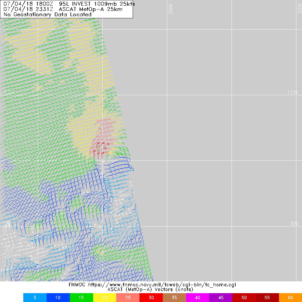
I stand corrected, ASCAT pass still shows an open wave but a very sharp wave axis.
1 likes   

User avatar
NotSparta
Professional-Met
Professional-Met
Posts: 1668
Age: 23
Joined: Fri Aug 18, 2017 8:24 am
Location: Naples, FL
Contact:

Re: ATL: INVEST 95L - Discussion

#144 Postby NotSparta » Wed Jul 04, 2018 7:17 pm

If this isn't already a TC, it's becoming one quickly.
0 likes   
This post was probably an opinion of mine, and in no way is official. Please refer to http://www.hurricanes.gov for official tropical analysis and advisories.

My website, with lots of tropical wx graphics, including satellite and recon: http://cyclonicwx.com

Alyono
Professional-Met
Professional-Met
Posts: 6961
Joined: Fri Apr 26, 2013 3:52 pm
Location: Texas Coast

Re: ATL: INVEST 95L - Discussion

#145 Postby Alyono » Wed Jul 04, 2018 7:17 pm

very close to being fully closed now. Not sure they will upgrade at 11 pm though without overwhelming evidence
2 likes   

User avatar
Gustywind
Category 5
Category 5
Posts: 12334
Joined: Mon Sep 03, 2007 7:29 am
Location: Baie-Mahault, GUADELOUPE

Re: ATL: INVEST 95L - Discussion

#146 Postby Gustywind » Wed Jul 04, 2018 7:20 pm

Aric Dunn wrote:Very moist pouch. saturated column and good moisture feed. should have a TD tonight and TS tomorrow if it can keep the SAL out.

Image

Hi Aric :). What are you best guess for this feature concerning those who lived in the EC like me, but especially those who are in the Leewards islands?
Holidays are just begin this weekend for most of the children of our island. Looks like 95 L is getting better and better since this afternoon so we should keep an eye on as near terms environnement does look favorable. Could we deal with a poor TD or weak TS close to the EC?
Thank for your legenderay input :D That is very important because of many of us are always Irma and Maria drama :oops: even if this feature cannot be compared. But you know that most of the citizens are always hurt. Anyway, bring us your best for 95L.
Regards.
Gustywind :)
1 likes   

User avatar
cycloneye
Admin
Admin
Posts: 145296
Age: 68
Joined: Thu Oct 10, 2002 10:54 am
Location: San Juan, Puerto Rico

Re: ATL: INVEST 95L - Discussion

#147 Postby cycloneye » Wed Jul 04, 2018 7:21 pm

Open Wave but good axis very sharp

Image
2 likes   
Visit the Caribbean-Central America Weather Thread where you can find at first post web cams,radars
and observations from Caribbean basin members Click Here

User avatar
NotSparta
Professional-Met
Professional-Met
Posts: 1668
Age: 23
Joined: Fri Aug 18, 2017 8:24 am
Location: Naples, FL
Contact:

Re: ATL: INVEST 95L - Discussion

#148 Postby NotSparta » Wed Jul 04, 2018 7:23 pm

ASCAT says still open.

Image

Not what you'd think if you look at satellite

Image
1 likes   
This post was probably an opinion of mine, and in no way is official. Please refer to http://www.hurricanes.gov for official tropical analysis and advisories.

My website, with lots of tropical wx graphics, including satellite and recon: http://cyclonicwx.com

User avatar
cycloneye
Admin
Admin
Posts: 145296
Age: 68
Joined: Thu Oct 10, 2002 10:54 am
Location: San Juan, Puerto Rico

Re: ATL: INVEST 95L - Discussion

#149 Postby cycloneye » Wed Jul 04, 2018 7:29 pm

SAB Up to 2.5.

TXNT26 KNES 050021
TCSNTL

A. TROPICAL DISTURBANCE (95L)

B. 04/2345Z

C. 10.6N

D. 38.1W

E. THREE/GOES-E

F. T2.5/2.5/D1.5/24HRS

G. IR/EIR/SWIR/SSMIS

H. REMARKS...0.65 CURVED BANDING RESULTS IN A DT OF 3.0. THE MET IS
2.0 AND THE PT IS 2.5. FT IS BASED ON PT DUE TO UNCERTAINTY IN BANDING
FEATURES AND PRECISE LOCATION OF LLCC.

I. ADDL POSITIONS

04/2040Z 10.6N 37.4W SSMIS


...HOSLEY
2 likes   
Visit the Caribbean-Central America Weather Thread where you can find at first post web cams,radars
and observations from Caribbean basin members Click Here

User avatar
BlowHard
S2K Supporter
S2K Supporter
Posts: 48
Age: 66
Joined: Thu Aug 27, 2015 9:15 pm
Location: Vieques, PR/Swansea, MA
Contact:

Re: ATL: INVEST 95L - Discussion

#150 Postby BlowHard » Wed Jul 04, 2018 7:29 pm

Ugh. PR doesn't need this. I'm pretty surprised it strengthened so quickly with all that SAL. I hope that shear does a number on it.
4 likes   
I am not a professional and this is just my opinion. Always refer to the professionals for advice.

User avatar
cycloneye
Admin
Admin
Posts: 145296
Age: 68
Joined: Thu Oct 10, 2002 10:54 am
Location: San Juan, Puerto Rico

Re: ATL: INVEST 95L - Discussion

#151 Postby cycloneye » Wed Jul 04, 2018 7:31 pm

BlowHard wrote:Ugh. PR doesn't need this. I'm pretty surprised it strengthened so quickly with all that SAL. I hope that shear does a number on it.


Agree 100%.
2 likes   
Visit the Caribbean-Central America Weather Thread where you can find at first post web cams,radars
and observations from Caribbean basin members Click Here

Aric Dunn
Category 5
Category 5
Posts: 21238
Age: 42
Joined: Sun Sep 19, 2004 9:58 pm
Location: Ready for the Chase.
Contact:

Re: ATL: INVEST 95L - Discussion

#152 Postby Aric Dunn » Wed Jul 04, 2018 7:33 pm

wait for high-resolution ascat. or someone find one. typical for small systems. this almost certainly is close.
0 likes   
Note: If I make a post that is brief. Please refer back to previous posts for the analysis or reasoning. I do not re-write/qoute what my initial post said each time.
If there is nothing before... then just ask :)

Space & Atmospheric Physicist, Embry-Riddle Aeronautical University,
I believe the sky is falling...

User avatar
StruThiO
Category 3
Category 3
Posts: 821
Age: 25
Joined: Fri Sep 15, 2017 5:51 am
Location: Currently Portland, OR. Raised in Jax, FL.

Re: ATL: INVEST 95L - Discussion

#153 Postby StruThiO » Wed Jul 04, 2018 7:35 pm

BlowHard wrote:Ugh. PR doesn't need this. I'm pretty surprised it strengthened so quickly with all that SAL. I hope that shear does a number on it.


Image

this will not make it to PR intact, luckily
2 likes   

User avatar
Gustywind
Category 5
Category 5
Posts: 12334
Joined: Mon Sep 03, 2007 7:29 am
Location: Baie-Mahault, GUADELOUPE

Re: ATL: INVEST 95L - Discussion

#154 Postby Gustywind » Wed Jul 04, 2018 7:36 pm

cycloneye wrote:
BlowHard wrote:Ugh. PR doesn't need this. I'm pretty surprised it strengthened so quickly with all that SAL. I hope that shear does a number on it.


Agree 100%.

:eek: All the leewardians too. Ramping up' 95L trend continue tonight. Hoping that 95L developpement should halt a bit during the next days :roll:
1 likes   

Aric Dunn
Category 5
Category 5
Posts: 21238
Age: 42
Joined: Sun Sep 19, 2004 9:58 pm
Location: Ready for the Chase.
Contact:

Re: ATL: INVEST 95L - Discussion

#155 Postby Aric Dunn » Wed Jul 04, 2018 7:46 pm

Gustywind wrote:
Aric Dunn wrote:Very moist pouch. saturated column and good moisture feed. should have a TD tonight and TS tomorrow if it can keep the SAL out.


Hi Aric :). What are you best guess for this feature concerning those who lived in the EC like me, but especially those who are in the Leewards islands?

Holidays are just begin this weekend for most of the children of our island. Looks like 95 L is getting better and better since this afternoon so we should keep an eye on as near terms environnement does look favorable. Could we deal with a poor TD or weak TS close to the EC?

Thank for your legenderay input :D That is very important because of many of us are always Irma and Maria drama :oops: even if this feature cannot be compared. But you know that most of
the citizens are always hurt. Anyway, bring us your best for 95L.

Regards.
Gustywind :)


It is very unlikely it will even survive to the islands. if it does nothing more than a TS at best.
0 likes   
Note: If I make a post that is brief. Please refer back to previous posts for the analysis or reasoning. I do not re-write/qoute what my initial post said each time.
If there is nothing before... then just ask :)

Space & Atmospheric Physicist, Embry-Riddle Aeronautical University,
I believe the sky is falling...

User avatar
Gustywind
Category 5
Category 5
Posts: 12334
Joined: Mon Sep 03, 2007 7:29 am
Location: Baie-Mahault, GUADELOUPE

Re: ATL: INVEST 95L - Discussion

#156 Postby Gustywind » Wed Jul 04, 2018 8:08 pm

Aric Dunn wrote: It is very unlikely it will even survive to the islands. if it does nothing more than a TS at best.


:) :sun: THANKS Aric we all hope that, rainmaker but no more to eradicate the drought 8-).
0 likes   

User avatar
Nimbus
Category 5
Category 5
Posts: 5300
Joined: Mon Jul 19, 2004 10:54 am

Re: ATL: INVEST 95L - Discussion

#157 Postby Nimbus » Wed Jul 04, 2018 8:16 pm

The persistent convection (which is reminiscent of a CDO but of course could not be) would have to remain quite small to survive a dry air encounter, even the light shear from the south would be drawing dryer air via inflow if it developed the more familiar thermal engine characteristics of a tropical cyclone.
0 likes   

User avatar
NotSparta
Professional-Met
Professional-Met
Posts: 1668
Age: 23
Joined: Fri Aug 18, 2017 8:24 am
Location: Naples, FL
Contact:

Re: ATL: INVEST 95L - Discussion

#158 Postby NotSparta » Wed Jul 04, 2018 8:21 pm

Never fear, FNMOC is here!

Image
0 likes   
This post was probably an opinion of mine, and in no way is official. Please refer to http://www.hurricanes.gov for official tropical analysis and advisories.

My website, with lots of tropical wx graphics, including satellite and recon: http://cyclonicwx.com

Aric Dunn
Category 5
Category 5
Posts: 21238
Age: 42
Joined: Sun Sep 19, 2004 9:58 pm
Location: Ready for the Chase.
Contact:

Re: ATL: INVEST 95L - Discussion

#159 Postby Aric Dunn » Wed Jul 04, 2018 8:24 pm

few westerly wind barbs in there. the higher resolution is still out there somewhere. lol
0 likes   
Note: If I make a post that is brief. Please refer back to previous posts for the analysis or reasoning. I do not re-write/qoute what my initial post said each time.
If there is nothing before... then just ask :)

Space & Atmospheric Physicist, Embry-Riddle Aeronautical University,
I believe the sky is falling...

User avatar
cycloneye
Admin
Admin
Posts: 145296
Age: 68
Joined: Thu Oct 10, 2002 10:54 am
Location: San Juan, Puerto Rico

Re: ATL: INVEST 95L - Discussion

#160 Postby cycloneye » Wed Jul 04, 2018 8:31 pm

00z Best Track:

Location: 10.4°N 38.0°W
Maximum Winds: 30 kt Gusts: N/A
Minimum Central Pressure: 1009 mb
Environmental Pressure: 1012 mb
Radius of Circulation: 120 NM
Radius of Maximum Wind: 40 NM
0 likes   
Visit the Caribbean-Central America Weather Thread where you can find at first post web cams,radars
and observations from Caribbean basin members Click Here


Return to “2018”

Who is online

Users browsing this forum: No registered users and 4 guests