WPAC: JEBI - Post-Tropical
Moderator: S2k Moderators
-
1900hurricane

- Category 5

- Posts: 6063
- Age: 34
- Joined: Fri Feb 06, 2015 12:04 pm
- Location: Houston, TX
- Contact:
Re: WPAC: JEBI - Typhoon
The eye is really starting to torch on all the WV band too. I know wind lag does sometimes affect intensifying tropical cyclones, but I think it is much more likely that JTWC is at least 20 kt too low right now.
0 likes
Contract Meteorologist. TAMU & MSST. Fiercely authentic, one of a kind. We are all given free will, so choose a life meant to be lived. We are the Masters of our own Stories.
Opinions expressed are mine alone.
Follow me on Twitter at @1900hurricane : Read blogs at https://1900hurricane.wordpress.com/
Opinions expressed are mine alone.
Follow me on Twitter at @1900hurricane : Read blogs at https://1900hurricane.wordpress.com/
-
mrbagyo

- Category 5
- Posts: 3963
- Age: 33
- Joined: Thu Apr 12, 2012 9:18 am
- Location: 14.13N 120.98E
- Contact:
Re: WPAC: JEBI - Typhoon
It's pretty obvious this is now a Super Typhoon.
I would laugh out loud if this is still below 130 on the next BT update.
I would laugh out loud if this is still below 130 on the next BT update.
0 likes
The posts in this forum are NOT official forecast and should not be used as such. They are just the opinion of the poster and may or may not be backed by sound meteorological data. They are NOT endorsed by any professional institution or storm2k.org. For official information, please refer to RSMC, NHC and NWS products.
-
1900hurricane
- Category 5
- Posts: 6063
- Age: 34
- Joined: Fri Feb 06, 2015 12:04 pm
- Location: Houston, TX
- Contact:
Re: WPAC: JEBI - Typhoon
I'm not sure if category 5s have ever existed simeltaneously on either end of the Pacific, but we may be headed that way now with Jebi and Norman.
1 likes
Contract Meteorologist. TAMU & MSST. Fiercely authentic, one of a kind. We are all given free will, so choose a life meant to be lived. We are the Masters of our own Stories.
Opinions expressed are mine alone.
Follow me on Twitter at @1900hurricane : Read blogs at https://1900hurricane.wordpress.com/
Opinions expressed are mine alone.
Follow me on Twitter at @1900hurricane : Read blogs at https://1900hurricane.wordpress.com/
-
1900hurricane
- Category 5
- Posts: 6063
- Age: 34
- Joined: Fri Feb 06, 2015 12:04 pm
- Location: Houston, TX
- Contact:
Re: WPAC: JEBI - Typhoon
JTWC adjusted upwards 10 kt for 12Z.
25W JEBI 180830 1200 17.8N 146.9E WPAC 120 933
0 likes
Contract Meteorologist. TAMU & MSST. Fiercely authentic, one of a kind. We are all given free will, so choose a life meant to be lived. We are the Masters of our own Stories.
Opinions expressed are mine alone.
Follow me on Twitter at @1900hurricane : Read blogs at https://1900hurricane.wordpress.com/
Opinions expressed are mine alone.
Follow me on Twitter at @1900hurricane : Read blogs at https://1900hurricane.wordpress.com/
-
Yellow Evan

- Professional-Met

- Posts: 16232
- Age: 27
- Joined: Fri Jul 15, 2011 12:48 pm
- Location: Henderson, Nevada/Honolulu, HI
- Contact:

-
mrbagyo
- Category 5
- Posts: 3963
- Age: 33
- Joined: Thu Apr 12, 2012 9:18 am
- Location: 14.13N 120.98E
- Contact:
Re: WPAC: JEBI - Typhoon
Pagan island is now being brutalized by the northern Eyewall of Jebi. So unfortunate that there's no instruments in the island.
0 likes
The posts in this forum are NOT official forecast and should not be used as such. They are just the opinion of the poster and may or may not be backed by sound meteorological data. They are NOT endorsed by any professional institution or storm2k.org. For official information, please refer to RSMC, NHC and NWS products.
-
1900hurricane
- Category 5
- Posts: 6063
- Age: 34
- Joined: Fri Feb 06, 2015 12:04 pm
- Location: Houston, TX
- Contact:
Re: WPAC: JEBI - Typhoon
With dual channels, outflow is awesome.

1 likes
Contract Meteorologist. TAMU & MSST. Fiercely authentic, one of a kind. We are all given free will, so choose a life meant to be lived. We are the Masters of our own Stories.
Opinions expressed are mine alone.
Follow me on Twitter at @1900hurricane : Read blogs at https://1900hurricane.wordpress.com/
Opinions expressed are mine alone.
Follow me on Twitter at @1900hurricane : Read blogs at https://1900hurricane.wordpress.com/
-
mrbagyo
- Category 5
- Posts: 3963
- Age: 33
- Joined: Thu Apr 12, 2012 9:18 am
- Location: 14.13N 120.98E
- Contact:
Re: WPAC: JEBI - Typhoon
90 knots
TY 1821 (Jebi)
Issued at 15:45 UTC, 30 August 2018
<Analysis at 15 UTC, 30 August>
Scale -
Intensity Very strong
Center position N17°55' (17.9°)
E146°05' (146.1°)
Direction and speed of movement W 20 km/h (12 kt)
Central pressure 940 hPa
Maximum wind speed near center 45 m/s (90 kt)
Maximum wind gust speed 65 m/s (130 kt)
≥ 50 kt wind area ALL 90 km (50 NM)
≥ 30 kt wind area N 330 km (180 NM)
S 280 km (150 NM)
0 likes
The posts in this forum are NOT official forecast and should not be used as such. They are just the opinion of the poster and may or may not be backed by sound meteorological data. They are NOT endorsed by any professional institution or storm2k.org. For official information, please refer to RSMC, NHC and NWS products.
Re: WPAC: JEBI - Typhoon
Given that JMA went with CI5.5 at 12Z, it is nearly impossible for them to go with an intensity estimate corresponding to a category 5 at the next advisory (they almost never break constraints), but the JTWC may go with a CI7.0.
0 likes
Personal Forecast Disclaimer:
The posts in this forum are NOT official forecast and should not be used as such. They are just the opinion of the poster and may or may not be backed by sound meteorological data. They are NOT endorsed by any professional institution or storm2k.org. For official information, please refer to RSMC and NWS products.
The posts in this forum are NOT official forecast and should not be used as such. They are just the opinion of the poster and may or may not be backed by sound meteorological data. They are NOT endorsed by any professional institution or storm2k.org. For official information, please refer to RSMC and NWS products.
-
1900hurricane
- Category 5
- Posts: 6063
- Age: 34
- Joined: Fri Feb 06, 2015 12:04 pm
- Location: Houston, TX
- Contact:
Re: WPAC: JEBI - Typhoon
JTWC is 7.0 across the board at 18Z.
TPPN10 PGTW 301829
A. TYPHOON 25W (JEBI)
B. 30/1800Z
C. 17.77N
D. 145.37E
E. ONE/HMWRI8
F. T7.0/7.0/D2.0/24HRS STT: D0.5/03HRS
G. IR/EIR
H. REMARKS: 05A/PBO IRREG EYE/ANMTN. WMG EYE SURROUNDED BY W
YIELDS AN E# OF 6.0. ADDED 1.0 FOR EYE ADJUSTMENT TO YIELD A DT
OF 7.0. MET AND PT AGREE. DBO DT.
I. ADDITIONAL POSITIONS:
30/1601Z 17.72N 145.82E AMS2
LOWE
0 likes
Contract Meteorologist. TAMU & MSST. Fiercely authentic, one of a kind. We are all given free will, so choose a life meant to be lived. We are the Masters of our own Stories.
Opinions expressed are mine alone.
Follow me on Twitter at @1900hurricane : Read blogs at https://1900hurricane.wordpress.com/
Opinions expressed are mine alone.
Follow me on Twitter at @1900hurricane : Read blogs at https://1900hurricane.wordpress.com/
-
1900hurricane
- Category 5
- Posts: 6063
- Age: 34
- Joined: Fri Feb 06, 2015 12:04 pm
- Location: Houston, TX
- Contact:
Re: WPAC: JEBI - Typhoon
140 kt.
25W JEBI 180830 1800 17.8N 145.4E WPAC 140 921
0 likes
Contract Meteorologist. TAMU & MSST. Fiercely authentic, one of a kind. We are all given free will, so choose a life meant to be lived. We are the Masters of our own Stories.
Opinions expressed are mine alone.
Follow me on Twitter at @1900hurricane : Read blogs at https://1900hurricane.wordpress.com/
Opinions expressed are mine alone.
Follow me on Twitter at @1900hurricane : Read blogs at https://1900hurricane.wordpress.com/
-
1900hurricane
- Category 5
- Posts: 6063
- Age: 34
- Joined: Fri Feb 06, 2015 12:04 pm
- Location: Houston, TX
- Contact:
Re: WPAC: JEBI - Typhoon
Maybe a real quick rather seamless eyewall replacement cycle coming up.

0 likes
Contract Meteorologist. TAMU & MSST. Fiercely authentic, one of a kind. We are all given free will, so choose a life meant to be lived. We are the Masters of our own Stories.
Opinions expressed are mine alone.
Follow me on Twitter at @1900hurricane : Read blogs at https://1900hurricane.wordpress.com/
Opinions expressed are mine alone.
Follow me on Twitter at @1900hurricane : Read blogs at https://1900hurricane.wordpress.com/
-
1900hurricane
- Category 5
- Posts: 6063
- Age: 34
- Joined: Fri Feb 06, 2015 12:04 pm
- Location: Houston, TX
- Contact:
Re: WPAC: JEBI - Typhoon
Here's a VIIRS pass nighttime visible image from a few hours ago.

1 likes
Contract Meteorologist. TAMU & MSST. Fiercely authentic, one of a kind. We are all given free will, so choose a life meant to be lived. We are the Masters of our own Stories.
Opinions expressed are mine alone.
Follow me on Twitter at @1900hurricane : Read blogs at https://1900hurricane.wordpress.com/
Opinions expressed are mine alone.
Follow me on Twitter at @1900hurricane : Read blogs at https://1900hurricane.wordpress.com/
-
1900hurricane
- Category 5
- Posts: 6063
- Age: 34
- Joined: Fri Feb 06, 2015 12:04 pm
- Location: Houston, TX
- Contact:
Re: WPAC: JEBI - Typhoon

0 likes
Contract Meteorologist. TAMU & MSST. Fiercely authentic, one of a kind. We are all given free will, so choose a life meant to be lived. We are the Masters of our own Stories.
Opinions expressed are mine alone.
Follow me on Twitter at @1900hurricane : Read blogs at https://1900hurricane.wordpress.com/
Opinions expressed are mine alone.
Follow me on Twitter at @1900hurricane : Read blogs at https://1900hurricane.wordpress.com/
-
mrbagyo
- Category 5
- Posts: 3963
- Age: 33
- Joined: Thu Apr 12, 2012 9:18 am
- Location: 14.13N 120.98E
- Contact:
Re: WPAC: JEBI - Typhoon
TY 1821 (Jebi)
Issued at 18:45 UTC, 30 August 2018
<Analysis at 18 UTC, 30 August>
Scale -
Intensity Very strong
Center position N17°50' (17.8°)
E145°25' (145.4°)
Direction and speed of movement W 20 km/h (12 kt)
Central pressure 925 hPa
Maximum wind speed near center 50 m/s (100 kt)
Maximum wind gust speed 70 m/s (140 kt)
≥ 50 kt wind area ALL 90 km (50 NM)
≥ 30 kt wind area N 330 km (180 NM)
S 280 km (150 NM)
0 likes
The posts in this forum are NOT official forecast and should not be used as such. They are just the opinion of the poster and may or may not be backed by sound meteorological data. They are NOT endorsed by any professional institution or storm2k.org. For official information, please refer to RSMC, NHC and NWS products.
-
mrbagyo
- Category 5
- Posts: 3963
- Age: 33
- Joined: Thu Apr 12, 2012 9:18 am
- Location: 14.13N 120.98E
- Contact:
Re: WPAC: JEBI - Typhoon
Jawdropping beauty

0 likes
The posts in this forum are NOT official forecast and should not be used as such. They are just the opinion of the poster and may or may not be backed by sound meteorological data. They are NOT endorsed by any professional institution or storm2k.org. For official information, please refer to RSMC, NHC and NWS products.
-
1900hurricane
- Category 5
- Posts: 6063
- Age: 34
- Joined: Fri Feb 06, 2015 12:04 pm
- Location: Houston, TX
- Contact:
Re: WPAC: JEBI - Typhoon
AMSU is getting really aggressive again.
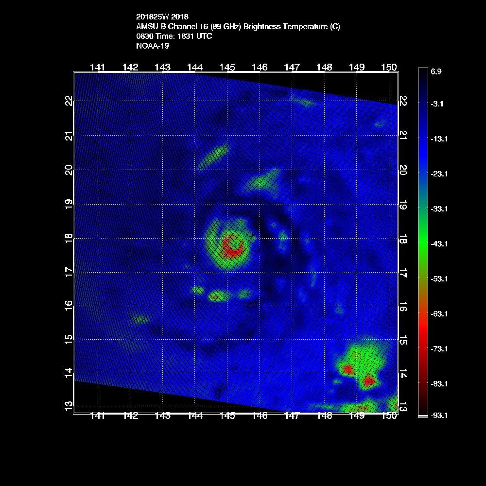

CIMSS/NESDIS-USAF/NRL AMSU TC Intensity Estimation:
SUPER TYPHOON 25W
Thursday 30aug18 Time: 1831 UTC
Latitude: 17.80 Longitude: 145.27
Storm position corresponds to AMSU-A FOV 22 [1<--->30]
-----------------------------------------------------------------
| Estimated MSLP: 915 hPa
| Estimated Maximum Sustained Wind: 163 kts
| Estimate Confidence: Good ( +/- 10mb +/- 12kts )
-----------------------------------------------------------------
Storm is sub-sampled: Bias correction applied is -26.8 hPa
Channel 8 (~150 hPa) Tb Anomaly: 2.82753
Channel 7 (~250 hPa) Tb Anomaly: 3.56
RMW: 9 km
RMW Source is: MW
Environmental Pressure: 1007
Satellite: NOAA-19
ATCF data for Month: 08 Day: 30 Time (UTC): 1800
For imagery, go to http://amsu.ssec.wisc.edu
For all comments and questions mailto:chrisv@ssec.wisc.edu
0 likes
Contract Meteorologist. TAMU & MSST. Fiercely authentic, one of a kind. We are all given free will, so choose a life meant to be lived. We are the Masters of our own Stories.
Opinions expressed are mine alone.
Follow me on Twitter at @1900hurricane : Read blogs at https://1900hurricane.wordpress.com/
Opinions expressed are mine alone.
Follow me on Twitter at @1900hurricane : Read blogs at https://1900hurricane.wordpress.com/


-
mrbagyo
- Category 5
- Posts: 3963
- Age: 33
- Joined: Thu Apr 12, 2012 9:18 am
- Location: 14.13N 120.98E
- Contact:
Re: WPAC: JEBI - Typhoon


0 likes
The posts in this forum are NOT official forecast and should not be used as such. They are just the opinion of the poster and may or may not be backed by sound meteorological data. They are NOT endorsed by any professional institution or storm2k.org. For official information, please refer to RSMC, NHC and NWS products.
-
euro6208
Re: WPAC: JEBI - Typhoon
WDPN31 PGTW 302100
MSGID/GENADMIN/JOINT TYPHOON WRNCEN PEARL HARBOR HI//
SUBJ/PROGNOSTIC REASONING FOR SUPER TYPHOON 25W (JEBI) WARNING NR
15//
RMKS/
1. FOR METEOROLOGISTS.
2. 6 HOUR SUMMARY AND ANALYSIS.
SUPER TYPHOON (STY) 25W (JEBI), LOCATED APPROXIMATELY 248 NM
NORTH OF ANDERSEN AFB, GUAM, HAS TRACKED WESTWARD AT 14 KNOTS OVER
THE PAST SIX HOURS. STY 25W HAS RAPIDLY INTENSIFIED OVER THE PAST 24
HOURS (50 KNOTS) FROM 90 KNOTS TO THE CURRENT INTENSITY OF 140
KNOTS. ANIMATED ENHANCED INFRARED SATELLITE IMAGERY DEPICTS A
COMPACT SYSTEM, APPROXIMATELY 160NM DIAMETER CENTRAL DENSE OVERCAST,
WITH A 15NM ROUND EYE. A 301801Z GMI 89GHZ IMAGE INDICATES A
SYMMETRIC CONVECTIVE STRUCTURE WITH MULTIPLE SPIRAL BANDS AND A
SMALL MICROWAVE EYE FEATURE, THEREFORE, THERE IS GOOD CONFIDENCE IN
THE INITIAL POSITION. THE INITIAL INTENSITY IS ASSESSED AT 140 KNOTS
BASED ON A PGTW DVORAK ESTIMATE OF T7.0 (140 KNOTS). ADDITIONAL
ESTIMATES ARE SLIGHTLY LOWER BUT SUPPORT THE UPGRADE TO SUPER
TYPHOON STATUS...KNES AND RJTD DVORAK ESTIMATES OF T6.5 (127 KNOTS)
AND A 30/1620Z SATCON ESTIMATE OF 130 KNOTS. UPPER-LEVEL ANALYSIS
REVEALS A VERY FAVORABLE ENVIRONMENT WITH LOW VERTICAL WIND SHEAR,
RADIAL OUTFLOW ENHANCED BY A TUTT CELL TO THE EAST, WARM SST (29-
31C) AND HIGH OCEAN HEAT CONTENT VALUES. STY 25W IS TRACKING ALONG
THE SOUTHERN PERIPHERY OF AN EAST-WEST ORIENTED SUBTROPICAL RIDGE
(STR).
3. FORECAST REASONING.
A. THERE IS NO CHANGE TO THE FORECAST PHILOSOPHY FROM THE
PREVIOUS WARNING.
B. STY 25W WILL CONTINUE TO TRACK WESTWARD TO WEST-NORTHWESTWARD
THROUGH TAU 36 THEN WILL TURN NORTHWESTWARD TO NORTH-NORTHWESTWARD
ALONG THE WESTERN PERIPHERY OF THE STR THROUGH TAU 72. NUMERICAL
MODEL GUIDANCE IS IN GOOD AGREEMENT THROUGH TAU 72 WITH A SPREAD OF
205NM AT TAU 72. BASED ON THE LOW UNCERTAINTY IN THE TRACK GUIDANCE,
CONFIDENCE IN THIS PORTION OF THE JTWC TRACK FORECAST IS HIGH.
ENVIRONMENTAL CONDITIONS ARE FORECAST TO REMAIN VERY FAVORABLE
THROUGH TAU 48, THEREFORE, THE SYSTEM WILL MAINTAIN SUPER TYPHOON
INTENSITY WITH A POTENTIAL PEAK OF 155 KNOTS IN THE NEXT 12 TO 24
HOURS. DUE TO THE LIKELIHOOD OF EYEWALL REPLACEMENT CYCLES
OCCURRING, THERE IS SOME UNCERTAINTY IN THE EXACT JTWC INTENSITY
FORECAST OVER THE NEXT FEW DAYS.
C. AFTER TAU 72, STY 25W WILL ACCELERATE NORTHWARD TO NORTH-
NORTHEASTWARD TOWARD CENTRAL HONSHU AS IT ROUNDS THE STR AXIS. STY
IS EXPECTED TO BEGIN EXTRA-TROPICAL TRANSITION (ETT) BY TAU 96 AS IT
BEGINS TO INTERACT WITH A DEEP MIDLATITUDE SHORTWAVE TROUGH DIGGING
INTO THE KOREAN PENINSULA AND WESTERN JAPAN. STY 25W WILL RAPIDLY
COMPLETE ETT AS IT BECOMES EMBEDDED WITHIN THE MIDLATITUDE SHORTWAVE
TROUGH AND GAINS FRONTAL CHARACTERISTICS OVER THE SEA OF JAPAN. THE
SYSTEM WILL RAPIDLY WEAKEN AFTER TAU 96 DUE TO INCREASING VERTICAL
WIND SHEAR AND INCREASED FRICTIONAL EFFECTS. ADDITIONALLY, COLD SST
VALUES SHOULD CONTRIBUTE TO FURTHER WEAKENING ONCE THE SYSTEM TRACKS
BACK OVER THE SEA OF JAPAN. AFTER COMPLETING ETT, THE OCCLUDING
EXTRA-TROPICAL LOW IS FORECAST TO MAINTAIN STORM-FORCE WINDS AS IT
TRACKS POLEWARD. DUE TO THE INCREASING SPREAD IN THE NUMERICAL MODEL
GUIDANCE ASSOCIATED WITH SIGNIFICANT DIFFERENCES IN THE TIMING OF
THE RECURVE AND TRACK SPEEDS, THERE IS LOW CONFIDENCE IN THIS
PORTION OF THE JTWC FORECAST TRACK.//
NNNN
0 likes
Who is online
Users browsing this forum: No registered users and 43 guests