EPAC: WILLA - Remnants

Moderator: S2k Moderators

Message
Author
supercane4867
Category 5
Category 5
Posts: 4966
Joined: Wed Nov 14, 2012 10:43 am

Re: EPAC: WILLA - Hurricane

#141 Postby supercane4867 » Sun Oct 21, 2018 6:44 pm

Sunset over Willa.

Image

Image
7 likes   

User avatar
Highteeld
Category 5
Category 5
Posts: 2097
Age: 40
Joined: Tue Jan 30, 2018 9:10 pm
Location: Chicago

Re: EPAC: WILLA - Hurricane

#142 Postby Highteeld » Sun Oct 21, 2018 7:00 pm

Image
Image
Image
2 likes   
Very useful information on the Dvorak Technique --

https://severe.worldweather.wmo.int/TCF ... kBeven.pdf

User avatar
Yellow Evan
Professional-Met
Professional-Met
Posts: 15959
Age: 25
Joined: Fri Jul 15, 2011 12:48 pm
Location: Henderson, Nevada/Honolulu, HI
Contact:

Re: EPAC: WILLA - Hurricane

#143 Postby Yellow Evan » Sun Oct 21, 2018 7:38 pm

Image

T6.0
0 likes   

User avatar
Yellow Evan
Professional-Met
Professional-Met
Posts: 15959
Age: 25
Joined: Fri Jul 15, 2011 12:48 pm
Location: Henderson, Nevada/Honolulu, HI
Contact:

Re: EPAC: WILLA - Hurricane

#144 Postby Yellow Evan » Sun Oct 21, 2018 7:51 pm

Image

Eye shrinking. This is about to ERC which would throw a wrench into things.
0 likes   

User avatar
Highteeld
Category 5
Category 5
Posts: 2097
Age: 40
Joined: Tue Jan 30, 2018 9:10 pm
Location: Chicago

Re: EPAC: WILLA - Hurricane

#145 Postby Highteeld » Sun Oct 21, 2018 7:51 pm

Image
0 likes   
Very useful information on the Dvorak Technique --

https://severe.worldweather.wmo.int/TCF ... kBeven.pdf

Ntxw
Storm2k Moderator
Storm2k Moderator
Posts: 21559
Joined: Wed Oct 21, 2009 6:34 pm
Location: DFW, Texas

Re: EPAC: WILLA - Hurricane

#146 Postby Ntxw » Sun Oct 21, 2018 9:01 pm

She is not done yet. Need a little more to complete CMG ring. Keep this up tonight and perhaps recon may find Cat 5 tomorrow morning.

Image
3 likes   
The above post and any post by Ntxw is NOT an official forecast and should not be used as such. It is just the opinion of the poster and may or may not be backed by sound meteorological data. It is NOT endorsed by any professional institution including Storm2k. For official information, please refer to NWS products.

  Help support Storm2K!
Help Support Storm2K

User avatar
cycloneye
Admin
Admin
Posts: 139520
Age: 67
Joined: Thu Oct 10, 2002 10:54 am
Location: San Juan, Puerto Rico

Re: EPAC: WILLA - Hurricane

#147 Postby cycloneye » Sun Oct 21, 2018 9:42 pm

BULLETIN
Hurricane Willa Advisory Number 8
NWS National Hurricane Center Miami FL EP242018
900 PM MDT Sun Oct 21 2018

...WILLA FORECAST TO PRODUCE LIFE-THREATENING STORM SURGE, WIND,
AND RAINFALL OVER PORTIONS OF WEST-CENTRAL AND SOUTHWESTERN
MEXICO...
...HURRICANE AND TROPICAL STORM WARNINGS HAVE BEEN ISSUED...


SUMMARY OF 900 PM MDT...0300 UTC...INFORMATION
----------------------------------------------
LOCATION...17.7N 107.2W
ABOUT 210 MI...340 KM SSW OF CABO CORRIENTES MEXICO
MAXIMUM SUSTAINED WINDS...145 MPH...230 KM/H
PRESENT MOVEMENT...NNW OR 340 DEGREES AT 7 MPH...11 KM/H
MINIMUM CENTRAL PRESSURE...941 MB...27.79 INCHES


WATCHES AND WARNINGS
--------------------
CHANGES WITH THIS ADVISORY:

The government of Mexico has replaced the Hurricane Watch from San
Blas to Mazatlan with a Hurricane Warning, and has replaced the
Tropical Storm Watch from north of Mazatlan to Bahia Tempehuaya
with a Tropical Storm Warning.

SUMMARY OF WATCHES AND WARNINGS IN EFFECT:

A Hurricane Warning is in effect for...
* San Blas to Mazatlan, including Las Islas Marias

A Tropical Storm Warning is in effect for...
* Playa Perula to San Blas
* North of Mazatlan to Bahia Tempehuaya


Hurricane Willa Discussion Number 8
NWS National Hurricane Center Miami FL EP242018
900 PM MDT Sun Oct 21 2018

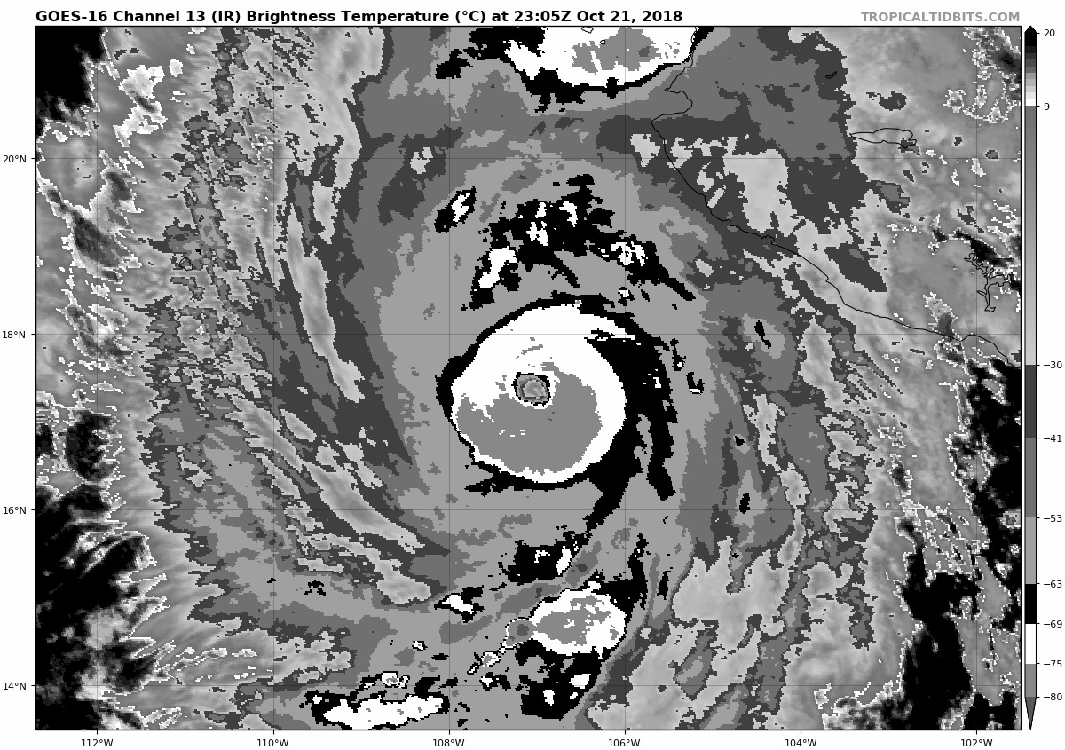
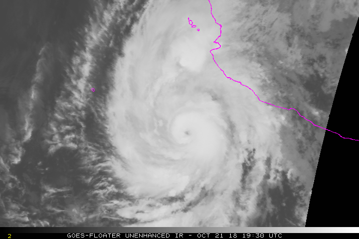
Willa has continued to rapidly intensify this evening. Satellite
images show a well-defined circular eye with a surrounding ring of
cold cloud tops that are near -80 deg C over the southeastern
quadrant. The initial intensity is set to 125 kt, which is near the
latest Dvorak ADT estimates from CIMSS at the University of
Wisconsin. Willa has strengthened at an incredible rate since
genesis, intensifying from a tropical depression to a category 4
hurricane in less than 48 hours.

Willa is gradually turning toward the right, with the initial motion
estimated to be 340/6 kt. The hurricane is expected to turn
northward on Monday as it moves around the western periphery of a
mid-level ridge to the east, followed by a faster northeastward
motion Monday night and Tuesday when a shortwave trough approaches
the system. The models are in fairly good agreement, and only small
changes were made to the previous NHC track forecast. On the
forecast track, Willa is expected to move over Las Islas Marias on
Tuesday and then move inland over southwestern and west-central
Mexico Tuesday night or early Wednesday.

The hurricane has certainty taken advantage of the near ideal
environmental conditions and since these conditions will persist a
little longer, some additional strengthening is shown in the short
term. However, some fluctuations in intensity could occur due to
eyewall replacement cycles. The models then show a gradual increase
in shear and a decrease in available moisture around 24 hours, and
these factors should cause a slow weakening trend. Regardless,
Willa is forecast to remain a dangerous hurricane, bringing multiple
life-threatening hazards to the coast of Mexico. Rapid weakening is
forecast after the system moves inland and interacts with the
mountainous terrain. The NHC intensity forecast lies near the high
end of the model guidance through dissipation.

Key Messages:

1. Willa is forecast to be a dangerous hurricane when it reaches the
Islas Marias and the coast of southwestern Mexico by late Tuesday or
Wednesday bringing a life-threatening storm surge and flash flooding
along with damaging hurricane-force winds. A Hurricane Warning is
in effect for these areas, and residents should rush preparations to
completion to protect life and property and follow any advice given
by local officials.


FORECAST POSITIONS AND MAX WINDS

INIT 22/0300Z 17.7N 107.2W 125 KT 145 MPH
12H 22/1200Z 18.6N 107.4W 135 KT 155 MPH
24H 23/0000Z 19.7N 107.5W 125 KT 145 MPH
36H 23/1200Z 20.7N 107.2W 115 KT 130 MPH
48H 24/0000Z 22.1N 106.2W 100 KT 115 MPH
72H 25/0000Z 26.2N 101.3W 30 KT 35 MPH...POST-TROP/INLAND
96H 26/0000Z...DISSIPATED

$$
Forecaster Cangialosi
0 likes   
Visit the Caribbean-Central America Weather Thread where you can find at first post web cams,radars
and observations from Caribbean basin members Click Here

supercane4867
Category 5
Category 5
Posts: 4966
Joined: Wed Nov 14, 2012 10:43 am

Re: EPAC: WILLA - Hurricane

#148 Postby supercane4867 » Sun Oct 21, 2018 9:52 pm

Starting to get the Linda look

Image

Image

Very tight inner core. No EWRC to speak of at the moment
3 likes   

Ntxw
Storm2k Moderator
Storm2k Moderator
Posts: 21559
Joined: Wed Oct 21, 2009 6:34 pm
Location: DFW, Texas

Re: EPAC: WILLA - Hurricane

#149 Postby Ntxw » Sun Oct 21, 2018 9:56 pm

Stunning core.

Image
3 likes   
The above post and any post by Ntxw is NOT an official forecast and should not be used as such. It is just the opinion of the poster and may or may not be backed by sound meteorological data. It is NOT endorsed by any professional institution including Storm2k. For official information, please refer to NWS products.


  Help support Storm2K!

Help Support Storm2K


supercane4867
Category 5
Category 5
Posts: 4966
Joined: Wed Nov 14, 2012 10:43 am

Re: EPAC: WILLA - Hurricane

#150 Postby supercane4867 » Sun Oct 21, 2018 9:58 pm

With eye temp nearing 20C, I'm pretty confident that recon will find a CAT5 in the morning.

CI# /Pressure/ Vmax
6.6 / 933.9mb/129.6kt


Final T# Adj T# Raw T#
6.6 6.9 6.9

Estimated radius of max. wind based on IR : 14 km

Center Temp : +16.4C Cloud Region Temp : -72.7C

Scene Type : EYE
0 likes   

Ntxw
Storm2k Moderator
Storm2k Moderator
Posts: 21559
Joined: Wed Oct 21, 2009 6:34 pm
Location: DFW, Texas

Re: EPAC: WILLA - Hurricane

#151 Postby Ntxw » Sun Oct 21, 2018 10:01 pm

supercane4867 wrote:With eye temp nearing 20C, I'm pretty confident that recon will find a CAT5 in the morning.

CI# /Pressure/ Vmax
6.6 / 933.9mb/129.6kt


Final T# Adj T# Raw T#
6.6 6.9 6.9

Estimated radius of max. wind based on IR : 14 km

Center Temp : +16.4C Cloud Region Temp : -72.7C

Scene Type : EYE


May not even need recon. Estimates may take it there if she continues where she is. I bet recon will find something in the 150kt range assuming it holds. Also some lower pressures given the tight core.
1 likes   
The above post and any post by Ntxw is NOT an official forecast and should not be used as such. It is just the opinion of the poster and may or may not be backed by sound meteorological data. It is NOT endorsed by any professional institution including Storm2k. For official information, please refer to NWS products.


  Help support Storm2K!

Help Support Storm2K


User avatar
Cunxi Huang
Category 1
Category 1
Posts: 323
Age: 25
Joined: Thu Sep 26, 2013 12:17 pm
Location: San Luis Obispo, CA

Re: EPAC: WILLA - Hurricane

#152 Postby Cunxi Huang » Sun Oct 21, 2018 10:02 pm

Image
Image

Oh man...
7 likes   
2006 SuTY SAOMAI | 2009 TY LINFA | 2010 TY FANAPI | 2010 SuTY MEGI | 2016 SuTY MERANTI | 2019 SuTY LEKIMA
DO NOT use my posts for life and death decisions. For official information, please refer to products from your RSMC and national weather agency.

supercane4867
Category 5
Category 5
Posts: 4966
Joined: Wed Nov 14, 2012 10:43 am

Re: EPAC: WILLA - Hurricane

#153 Postby supercane4867 » Sun Oct 21, 2018 10:11 pm

Beautiful system

Image
6 likes   

supercane4867
Category 5
Category 5
Posts: 4966
Joined: Wed Nov 14, 2012 10:43 am

Re: EPAC: WILLA - Hurricane

#154 Postby supercane4867 » Sun Oct 21, 2018 10:14 pm

1-minute interval sector shows the CDO is still cooling. Could it make a run for 155kt?
1 likes   

User avatar
Highteeld
Category 5
Category 5
Posts: 2097
Age: 40
Joined: Tue Jan 30, 2018 9:10 pm
Location: Chicago

Re: EPAC: WILLA - Hurricane

#155 Postby Highteeld » Sun Oct 21, 2018 10:15 pm

Over 130 knots on SATCON right now, and a huge burst of -85* cloud tops. Cat 5 in as little as 2-3 hours.

Image
Image
Image

Edit*
It might already be there at cat 5.
0 likes   
Very useful information on the Dvorak Technique --

https://severe.worldweather.wmo.int/TCF ... kBeven.pdf

Ntxw
Storm2k Moderator
Storm2k Moderator
Posts: 21559
Joined: Wed Oct 21, 2009 6:34 pm
Location: DFW, Texas

Re: EPAC: WILLA - Hurricane

#156 Postby Ntxw » Sun Oct 21, 2018 10:20 pm

This thing is going for it. It looks just as good as Walaka did. Sure wish included this evening.

UW - CIMSS
ADVANCED DVORAK TECHNIQUE
ADT-Version 9.0
Tropical Cyclone Intensity Algorithm

----- Current Analysis -----
Date : 22 OCT 2018 Time : 024536 UTC
Lat : 17:31:48 N Lon : 107:10:11 W


CI# /Pressure/ Vmax
6.7 / 931.5mb/132.2kt


Final T# Adj T# Raw T#
6.7 7.0 7.0

Estimated radius of max. wind based on IR : 14 km

Center Temp : +16.2C Cloud Region Temp : -73.0C

Scene Type : EYE
1 likes   
The above post and any post by Ntxw is NOT an official forecast and should not be used as such. It is just the opinion of the poster and may or may not be backed by sound meteorological data. It is NOT endorsed by any professional institution including Storm2k. For official information, please refer to NWS products.


  Help support Storm2K!

Help Support Storm2K


hurricanes1234
Category 5
Category 5
Posts: 2904
Joined: Sat Jul 28, 2012 6:19 pm
Location: Trinidad and Tobago

Re: EPAC: WILLA - Hurricane

#157 Postby hurricanes1234 » Sun Oct 21, 2018 10:26 pm

I realise current hurricanes which resemble past hurricanes, tend to occur around the same date and in a similar fashion (I hope that's understandable as I'm not really sure how to describe it). :lol:

Yet, was it not 3 years ago, perhaps to the very day, that the world was watching a certain hurricane starting with the letter P, in a similar region and Mexico-bound as well, continue its explosive intensification during the nighttime hours, with recon being thrown in the mix as well? The similarities are simply mind-boggling. :eek:
1 likes   
PLEASE NOTE: With the exception of information from weather agencies that I may copy and paste here, my posts will NEVER be official, since I am NOT a meteorologist. They are solely my amateur opinion, and may or may not be accurate. Therefore, please DO NOT use them as official details, particularly when making important decisions. Thank you.

supercane4867
Category 5
Category 5
Posts: 4966
Joined: Wed Nov 14, 2012 10:43 am

Re: EPAC: WILLA - Hurricane

#158 Postby supercane4867 » Sun Oct 21, 2018 10:31 pm

2 likes   

Ntxw
Storm2k Moderator
Storm2k Moderator
Posts: 21559
Joined: Wed Oct 21, 2009 6:34 pm
Location: DFW, Texas

Re: EPAC: WILLA - Hurricane

#159 Postby Ntxw » Sun Oct 21, 2018 10:32 pm

hurricanes1234 wrote:I realise current hurricanes which resemble past hurricanes, tend to occur around the same date and in a similar fashion (I hope that's understandable as I'm not really sure how to describe it). :lol:

Yet, was it not 3 years ago, perhaps to the very day, that the world was watching a certain hurricane starting with the letter P, in a similar region and Mexico-bound as well, continue its explosive intensification during the nighttime hours, with recon being thrown in the mix as well? The similarities are simply mind-boggling. :eek:


This is nowhere near the voracity of Patricia. But it is similar in the sense you labeled. Maybe not technically, but anecdotally you are looking at similar circumstances and evolution. Patricia just had higher fuel, this is maxing out the fuel that is given for this stamp in time.

Given how rapidly it intensified, and the tight, small core within a larger envelope, and trough nearby I just have a feeling the pressure gradient must be intense like Patricia or Linda condensed and compact. In my opinion, this is pretty much a Cat5.
6 likes   
The above post and any post by Ntxw is NOT an official forecast and should not be used as such. It is just the opinion of the poster and may or may not be backed by sound meteorological data. It is NOT endorsed by any professional institution including Storm2k. For official information, please refer to NWS products.


  Help support Storm2K!

Help Support Storm2K


User avatar
Highteeld
Category 5
Category 5
Posts: 2097
Age: 40
Joined: Tue Jan 30, 2018 9:10 pm
Location: Chicago

Re: EPAC: WILLA - Hurricane

#160 Postby Highteeld » Sun Oct 21, 2018 10:34 pm

There's the CMG ring we all were waiting for. Let's see how it grows, or if we can get some CDG in the mix. Either way, this thing is a beast.

Image
Last edited by Highteeld on Sun Oct 21, 2018 10:40 pm, edited 1 time in total.
2 likes   
Very useful information on the Dvorak Technique --

https://severe.worldweather.wmo.int/TCF ... kBeven.pdf


Return to “2018”

Who is online

Users browsing this forum: No registered users and 7 guests