10W MARIA 180705 0600 14.6N 143.4E WPAC 70 981
Upgraded to a Cat 1.
WPAC: MARIA - Post-Tropical
Moderator: S2k Moderators
-
mrbagyo

- Category 5

- Posts: 3963
- Age: 33
- Joined: Thu Apr 12, 2012 9:18 am
- Location: 14.13N 120.98E
- Contact:
Re: WPAC: MARIA - Severe Tropical Storm
Maria is trying to rebuild her CDO.

0 likes
The posts in this forum are NOT official forecast and should not be used as such. They are just the opinion of the poster and may or may not be backed by sound meteorological data. They are NOT endorsed by any professional institution or storm2k.org. For official information, please refer to RSMC, NHC and NWS products.


-
doomhaMwx

- Category 5
- Posts: 2487
- Age: 27
- Joined: Tue Apr 18, 2017 4:01 am
- Location: Baguio/Benguet, Philippines
- Contact:
Re: WPAC: MARIA - Severe Tropical Storm
xtyphooncyclonex wrote:This would be the biggest ACE storm in the Western Pacific since Nangka in 2015. I anticipate this season to be an active one, especially compared to the last two seasons. A harbinger of things to come.
Coincidentally, the last Category 5 in the Northern Hemisphere was a problem called Maria. This is very likely to skyrocket to and maintain that intensity.
Not Noru of 2017?
0 likes
-
cycloneye

- Admin

- Posts: 149369
- Age: 69
- Joined: Thu Oct 10, 2002 10:54 am
- Location: San Juan, Puerto Rico
Re: WPAC: MARIA - Severe Tropical Storm
JMA still at Severe Tropica Storm:
STS 1808 (Maria)
Issued at 09:45 UTC, 5 July 2018
<Analysis at 09 UTC, 5 July>
Scale -
Intensity -
Center position N14°35' (14.6°)
E143°00' (143.0°)
Direction and speed of movement WNW 15 km/h (9 kt)
Central pressure 992 hPa
Maximum wind speed near center 25 m/s (50 kt)
Maximum wind gust speed 35 m/s (70 kt)
≥ 30 kt wind area E 330 km (180 NM)
W 220 km (120 NM)
<Forecast for 09 UTC, 6 July>
Intensity Strong
Center position of probability circle N16°30' (16.5°)
E141°40' (141.7°)
Direction and speed of movement NNW 10 km/h (6 kt)
Central pressure 980 hPa
Maximum wind speed near center 35 m/s (65 kt)
Maximum wind gust speed 50 m/s (95 kt)
Radius of probability circle 90 km (50 NM)
Storm warning area ALL 170 km (90 NM)
<Forecast for 06 UTC, 7 July>
Intensity Strong
Center position of probability circle N18°25' (18.4°)
E141°10' (141.2°)
Direction and speed of movement NNW Slow
Central pressure 960 hPa
Maximum wind speed near center 40 m/s (80 kt)
Maximum wind gust speed 60 m/s (115 kt)
Radius of probability circle 180 km (95 NM)
Storm warning area ALL 280 km (150 NM)
<Forecast for 06 UTC, 8 July>
Intensity Very strong
Center position of probability circle N20°35' (20.6°)
E138°40' (138.7°)
Direction and speed of movement NW 15 km/h (8 kt)
Central pressure 940 hPa
Maximum wind speed near center 50 m/s (95 kt)
Maximum wind gust speed 70 m/s (135 kt)
Radius of probability circle 240 km (130 NM)
Storm warning area ALL 370 km (200 NM)
<Forecast for 06 UTC, 9 July>
Center position of probability circle N23°05' (23.1°)
E134°10' (134.2°)
Direction and speed of movement WNW 20 km/h (11 kt)
Radius of probability circle 370 km (200 NM)
<Forecast for 06 UTC, 10 July>
Center position of probability circle N26°00' (26.0°)
E128°50' (128.8°)
Direction and speed of movement WNW 25 km/h (14 kt)
Radius of probability circle 540 km (290 NM)
0 likes
Visit the Caribbean-Central America Weather Thread where you can find at first post web cams,radars
and observations from Caribbean basin members Click Here
and observations from Caribbean basin members Click Here
-
xtyphooncyclonex

- Category 5
- Posts: 3891
- Age: 24
- Joined: Sat Dec 08, 2012 9:07 am
- Location: Cebu City
- Contact:
Re: WPAC: MARIA - Severe Tropical Storm
Imran_doomhaMwx wrote:xtyphooncyclonex wrote:This would be the biggest ACE storm in the Western Pacific since Nangka in 2015. I anticipate this season to be an active one, especially compared to the last two seasons. A harbinger of things to come.
Coincidentally, the last Category 5 in the Northern Hemisphere was a problem called Maria. This is very likely to skyrocket to and maintain that intensity.
Not Noru of 2017?
Neither!
I did some research again and it's actually Chaba in 2004. Held onto cat 5 for a while. Not Ioke though, that was from the CPac and while still impressive, only half of its ACE went to the WPac
0 likes
REMINDER: My opinions that I, or any other NON Pro-Met in this forum, are unofficial. Please do not take my opinions as an official forecast and warning. I am NOT a meteorologist. Following my forecasts blindly may lead to false alarm, danger and risk if official forecasts from agencies are ignored.
-
xtyphooncyclonex
- Category 5
- Posts: 3891
- Age: 24
- Joined: Sat Dec 08, 2012 9:07 am
- Location: Cebu City
- Contact:
Re: WPAC: MARIA - Severe Tropical Storm
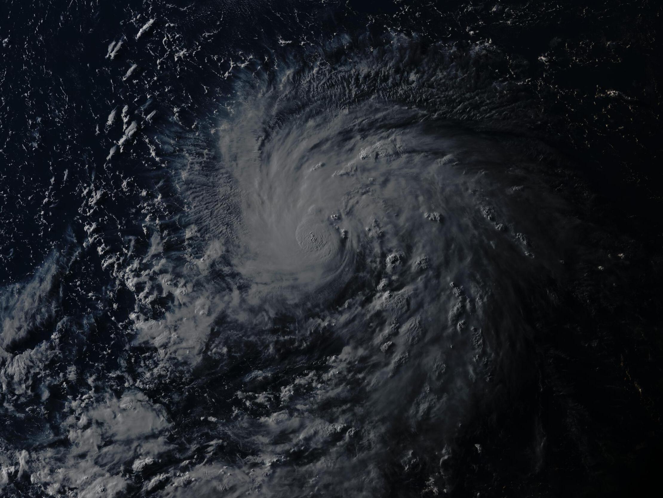
Imran_doomhaMwx wrote:Sunset Himawari-8 RGB image
07-05-2018 08:00am UTC
It does look ominous yet beautiful.
0 likes
REMINDER: My opinions that I, or any other NON Pro-Met in this forum, are unofficial. Please do not take my opinions as an official forecast and warning. I am NOT a meteorologist. Following my forecasts blindly may lead to false alarm, danger and risk if official forecasts from agencies are ignored.
-
1900hurricane

- Category 5
- Posts: 6063
- Age: 34
- Joined: Fri Feb 06, 2015 12:04 pm
- Location: Houston, TX
- Contact:
Re: WPAC: MARIA - Severe Tropical Storm
xtyphooncyclonex wrote:Imran_doomhaMwx wrote:xtyphooncyclonex wrote:This would be the biggest ACE storm in the Western Pacific since Nangka in 2015. I anticipate this season to be an active one, especially compared to the last two seasons. A harbinger of things to come.
Coincidentally, the last Category 5 in the Northern Hemisphere was a problem called Maria. This is very likely to skyrocket to and maintain that intensity.
Not Noru of 2017?
Neither!
I did some research again and it's actually Chaba in 2004. Held onto cat 5 for a while. Not Ioke though, that was from the CPac and while still impressive, only half of its ACE went to the WPac
The most WPac ACE for an individual storm since the turn of the century belongs to Fengshen '02. I do not believe Maria will challenge that.
Last edited by 1900hurricane on Thu Jul 05, 2018 7:13 am, edited 1 time in total.
0 likes
Contract Meteorologist. TAMU & MSST. Fiercely authentic, one of a kind. We are all given free will, so choose a life meant to be lived. We are the Masters of our own Stories.
Opinions expressed are mine alone.
Follow me on Twitter at @1900hurricane : Read blogs at https://1900hurricane.wordpress.com/
Opinions expressed are mine alone.
Follow me on Twitter at @1900hurricane : Read blogs at https://1900hurricane.wordpress.com/
Re: WPAC: MARIA - Severe Tropical Storm
JMA's latest Dvorak analysis is still ridiculously low at T3.5.
0 likes
Personal Forecast Disclaimer:
The posts in this forum are NOT official forecast and should not be used as such. They are just the opinion of the poster and may or may not be backed by sound meteorological data. They are NOT endorsed by any professional institution or storm2k.org. For official information, please refer to RSMC and NWS products.
The posts in this forum are NOT official forecast and should not be used as such. They are just the opinion of the poster and may or may not be backed by sound meteorological data. They are NOT endorsed by any professional institution or storm2k.org. For official information, please refer to RSMC and NWS products.
-
1900hurricane
- Category 5
- Posts: 6063
- Age: 34
- Joined: Fri Feb 06, 2015 12:04 pm
- Location: Houston, TX
- Contact:
Re: WPAC: MARIA - Severe Tropical Storm
Yeah, that's low. The center is embedded in black or colder, so the instantaneous DT at least should be 5.0.
0 likes
Contract Meteorologist. TAMU & MSST. Fiercely authentic, one of a kind. We are all given free will, so choose a life meant to be lived. We are the Masters of our own Stories.
Opinions expressed are mine alone.
Follow me on Twitter at @1900hurricane : Read blogs at https://1900hurricane.wordpress.com/
Opinions expressed are mine alone.
Follow me on Twitter at @1900hurricane : Read blogs at https://1900hurricane.wordpress.com/
-
euro6208
Re: WPAC: MARIA - Severe Tropical Storm
Up to 80 knots.
10W MARIA 180705 1200 14.8N 142.7E WPAC 80 963
10W MARIA 180705 1200 14.8N 142.7E WPAC 80 963
0 likes

Re: WPAC: MARIA - Severe Tropical Storm
NotoSans wrote:JMA's latest Dvorak analysis is still ridiculously low at T3.5.
I know Dvorak and all, but Maria is still on Guam radar:

Just watch the long range loop, this is a typhoon.
https://www.wunderground.com/weather-radar/united-states/gu/agana/gua/?region=gua
1 likes
-
euro6208
Re: WPAC: MARIA - Severe Tropical Storm
All warnings cancelled for the Marianas as Typhoon Maria moves away...
0 likes
-
euro6208
Re: WPAC: MARIA - Severe Tropical Storm

CURRENT ESTIMATE
Date (mmddhhmm): 07050850
SATCON: MSLP = 963 hPa MSW = 83 knots
SATCON Member Consensus: 82.0 knots
Pressure -> Wind Using SATCON MSLP: 86 knots
Distance to Outer Closed Isobar Used is 180 nm
Eye Size Correction Used is 0 knots Source: NA
Member Estimates
ADT: 977 hPa 75 knots Scene: CDO Date: JUL051140
CIMSS AMSU: 957 hPa 89 knots Bias Corr: 0 (MW) Date: 07050850
ATMS: 982.3 hPa 66.7 knots Date: 07050349
SSMIS: 961.0 hPa 92.0 knots Date: 07050839
CIRA ATMS: 981 hPa 67 knots Date:


Models are becoming tightly clustered towards Maria's next landfall...

Last edited by euro6208 on Thu Jul 05, 2018 8:22 am, edited 2 times in total.
0 likes
-
mrbagyo
- Category 5
- Posts: 3963
- Age: 33
- Joined: Thu Apr 12, 2012 9:18 am
- Location: 14.13N 120.98E
- Contact:
Re: WPAC: MARIA - Severe Tropical Storm
T number will jump once the eye starts to appear.

0 likes
The posts in this forum are NOT official forecast and should not be used as such. They are just the opinion of the poster and may or may not be backed by sound meteorological data. They are NOT endorsed by any professional institution or storm2k.org. For official information, please refer to RSMC, NHC and NWS products.
-
xtyphooncyclonex
- Category 5
- Posts: 3891
- Age: 24
- Joined: Sat Dec 08, 2012 9:07 am
- Location: Cebu City
- Contact:
Re: WPAC: MARIA - Severe Tropical Storm
1900hurricane wrote:xtyphooncyclonex wrote:Imran_doomhaMwx wrote:Not Noru of 2017?
Neither!
I did some research again and it's actually Chaba in 2004. Held onto cat 5 for a while. Not Ioke though, that was from the CPac and while still impressive, only half of its ACE went to the WPac
The most WPac ACE for an individual storm since the turn of the century belongs to Fengshen '02. I do not believe Maria will challenge that.
I don't believe Maria would challenge Fengshen, but it could surpass both Nangka and Noru---both at around 45 units. If it would become a category 4 tomorrow (which I think) and even a super typhoon while maintaining it for days, it's easy. The highest after Fengshen (in the 21st century) is indeed Chaba.
0 likes
REMINDER: My opinions that I, or any other NON Pro-Met in this forum, are unofficial. Please do not take my opinions as an official forecast and warning. I am NOT a meteorologist. Following my forecasts blindly may lead to false alarm, danger and risk if official forecasts from agencies are ignored.
-
cycloneye
- Admin
- Posts: 149369
- Age: 69
- Joined: Thu Oct 10, 2002 10:54 am
- Location: San Juan, Puerto Rico
Re: WPAC: MARIA - Severe Tropical Storm
I can't understand why JMA is still at Severe Tropical Storm.
STS 1808 (Maria)
Issued at 12:45 UTC, 5 July 2018
<Analysis at 12 UTC, 5 July>
Scale -
Intensity -
Center position N14°40' (14.7°)
E142°35' (142.6°)
Direction and speed of movement W 15 km/h (8 kt)
Central pressure 980 hPa
Maximum wind speed near center 30 m/s (60 kt)
Maximum wind gust speed 45 m/s (85 kt)
≥ 50 kt wind area ALL 70 km (40 NM)
≥ 30 kt wind area E 330 km (180 NM)
W 220 km (120 NM)
<Forecast for 12 UTC, 6 July>
Intensity Strong
Center position of probability circle N16°30' (16.5°)
E141°25' (141.4°)
Direction and speed of movement NNW Slow
Central pressure 965 hPa
Maximum wind speed near center 40 m/s (75 kt)
Maximum wind gust speed 55 m/s (105 kt)
Radius of probability circle 90 km (50 NM)
Storm warning area ALL 200 km (110 NM)
<Forecast for 12 UTC, 7 July>
Intensity Very strong
Center position of probability circle N18°30' (18.5°)
E141°05' (141.1°)
Direction and speed of movement N Slow
Central pressure 940 hPa
Maximum wind speed near center 45 m/s (90 kt)
Maximum wind gust speed 65 m/s (130 kt)
Radius of probability circle 180 km (95 NM)
Storm warning area ALL 330 km (180 NM)
<Forecast for 12 UTC, 8 July>
Intensity Very strong
Center position of probability circle N21°05' (21.1°)
E138°10' (138.2°)
Direction and speed of movement NW 15 km/h (9 kt)
Central pressure 925 hPa
Maximum wind speed near center 50 m/s (100 kt)
Maximum wind gust speed 70 m/s (140 kt)
Radius of probability circle 240 km (130 NM)
Storm warning area ALL 440 km (240 NM)
<Forecast for 12 UTC, 9 July>
Center position of probability circle N23°35' (23.6°)
E133°00' (133.0°)
Direction and speed of movement WNW 25 km/h (14 kt)
Radius of probability circle 370 km (200 NM)
<Forecast for 12 UTC, 10 July>
Center position of probability circle N26°20' (26.3°)
E127°30' (127.5°)
Direction and speed of movement WNW 25 km/h (14 kt)
Radius of probability circle 540 km (290 NM)
0 likes
Visit the Caribbean-Central America Weather Thread where you can find at first post web cams,radars
and observations from Caribbean basin members Click Here
and observations from Caribbean basin members Click Here
-
mrbagyo
- Category 5
- Posts: 3963
- Age: 33
- Joined: Thu Apr 12, 2012 9:18 am
- Location: 14.13N 120.98E
- Contact:
Re: WPAC: MARIA - Severe Tropical Storm
Wish Japan would send a recon plane into Maria - just like what they did last year to Typhoon Lan.
I think it's just apt since Maria could be a threat to their country
I think it's just apt since Maria could be a threat to their country
2 likes
The posts in this forum are NOT official forecast and should not be used as such. They are just the opinion of the poster and may or may not be backed by sound meteorological data. They are NOT endorsed by any professional institution or storm2k.org. For official information, please refer to RSMC, NHC and NWS products.
-
euro6208
Re: WPAC: MARIA - Severe Tropical Storm
cycloneye wrote:I can't understand why JMA is still at Severe Tropical Storm.
60 knots 10 minute equals to at least a minimum typhoon 1 minute. The stronger a typhoon gets, the more disparity it gets unfortunately...That's how their scale works.
1 likes
Who is online
Users browsing this forum: No registered users and 48 guests