ATL: FLORENCE - Post-Tropical - Discussion

Moderator: S2k Moderators

Message
Author
HurricaneIrma
Tropical Low
Tropical Low
Posts: 36
Age: 43
Joined: Mon Sep 03, 2018 9:37 am
Location: Wilmington NC

Re: ATL: FLORENCE - Hurricane - Discussion

#221 Postby HurricaneIrma » Tue Sep 04, 2018 10:19 pm

TheStormExpert wrote:
galaxy401 wrote:This part of the discussion is interesting. They mention the split in the models.

A look at the ensemble guidance
shows a bifurcation developing by day 5, with the ECMWF favoring
a more northward turn, and the UKMET ensembles showing a stronger
ridge and a continuation of a west-northwest track. The new NHC
forecast is adjusted westward at long range, in line with the
corrected-consensus aids, but don't be surprised if this forecast
undergoes some large changes in the next few cycles
, given the
split in the guidance.

Large changes is some strong wording! :eek:


something Monstrous could come out of this thing
1 likes   

User avatar
Ptarmigan
Category 5
Category 5
Posts: 5273
Joined: Wed Aug 16, 2006 9:06 pm

Re: ATL: FLORENCE - Hurricane - Discussion

#222 Postby Ptarmigan » Tue Sep 04, 2018 10:42 pm

First major hurricane of the Atlantic 2018 season?
6 likes   

User avatar
Hurricaneman
Category 5
Category 5
Posts: 7285
Age: 43
Joined: Tue Aug 31, 2004 3:24 pm
Location: central florida

Re: ATL: FLORENCE - Hurricane - Discussion

#223 Postby Hurricaneman » Tue Sep 04, 2018 11:01 pm

My thing here is if this moves slower than forecast then it may not matter the intensity because the escape hatch will close and this will go west, I can think of 5 possibilities in order from most likely to least

1. A possible Fabian 2003 track. 30%
2. A possible Andrew 1992 Track 25%
3. A track between Bermuda and North Carolina. 20%
4 A possible 1944 hurricane track. 15%
5 Out to sea without impact 10%

So as you can see this could get quite ugly and this will have to be watched
0 likes   

User avatar
TheStormExpert
Category 5
Category 5
Posts: 8487
Age: 30
Joined: Wed Feb 16, 2011 5:38 pm
Location: Palm Beach Gardens, FL

Re: ATL: FLORENCE - Hurricane - Discussion

#224 Postby TheStormExpert » Tue Sep 04, 2018 11:08 pm

Hurricaneman wrote:My thing here is if this moves slower than forecast then it may not matter the intensity because the escape hatch will close and this will go west, I can think of 5 possibilities in order from most likely to least

1. A possible Fabian 2003 track. 30%
2. A possible Andrew 1992 Track 25%
3. A track between Bermuda and North Carolina. 20%
4 A possible 1944 hurricane track. 15%
5 Out to sea without impact 10%

So as you can see this could get quite ugly and this will have to be watched

I wouldn’t say an Andrew track is 25%. More likely 5%, if that.
1 likes   
The following post is NOT an official forecast and should not be used as such. It is just the opinion of the poster and may or may not be backed by sound meteorological data. It is NOT endorsed by storm2k.org.

User avatar
cjrciadt
S2K Supporter
S2K Supporter
Posts: 1615
Joined: Mon Aug 22, 2005 1:11 pm
Location: Kissimmee, FL

Re: ATL: FLORENCE - Hurricane - Discussion

#225 Postby cjrciadt » Tue Sep 04, 2018 11:20 pm

5.7 Raw T Number
1 likes   

bob rulz
Category 5
Category 5
Posts: 1667
Age: 34
Joined: Sat Jan 28, 2006 7:30 pm
Location: Salt Lake City, Utah

Re: ATL: FLORENCE - Hurricane - Discussion

#226 Postby bob rulz » Wed Sep 05, 2018 12:00 am

Where do people go for their satellite imagery nowadays? The SSD link I used to use for floaters doesn't have the floaters up anymore.
0 likes   

Sciencerocks
Category 5
Category 5
Posts: 7351
Age: 38
Joined: Thu Jul 06, 2017 1:51 am

Re: ATL: FLORENCE - Hurricane - Discussion

#227 Postby Sciencerocks » Wed Sep 05, 2018 12:09 am

bob rulz wrote:Where do people go for their satellite imagery nowadays? The SSD link I used to use for floaters doesn't have the floaters up anymore.


Imagine how great a ssd visiable loop would be with the new satellite. Hopefully ssd figures out how to do them for the new satellite soon.

I use weathernerds or tropical tidbits...The problem with them is they're different compared to every other year within the archives I am doing so it is harder to compare storms.

IR is vastly different colors from every other year.
No Dvorak
0 likes   

User avatar
Hurricaneman
Category 5
Category 5
Posts: 7285
Age: 43
Joined: Tue Aug 31, 2004 3:24 pm
Location: central florida

Re: ATL: FLORENCE - Hurricane - Discussion

#228 Postby Hurricaneman » Wed Sep 05, 2018 12:29 am

Ptarmigan wrote:First major hurricane of the Atlantic 2018 season?

Almost a certainty
1 likes   

Chris90
Category 2
Category 2
Posts: 640
Age: 34
Joined: Thu Jun 01, 2017 9:36 pm

Re: ATL: FLORENCE - Hurricane - Discussion

#229 Postby Chris90 » Wed Sep 05, 2018 2:03 am

Sciencerocks wrote:
bob rulz wrote:Where do people go for their satellite imagery nowadays? The SSD link I used to use for floaters doesn't have the floaters up anymore.


Imagine how great a ssd visiable loop would be with the new satellite. Hopefully ssd figures out how to do them for the new satellite soon.

I use weathernerds or tropical tidbits...The problem with them is they're different compared to every other year within the archives I am doing so it is harder to compare storms.

IR is vastly different colors from every other year.
No Dvorak


Here's a link for SSD floaters: http://www.ssd.noaa.gov/PS/TROP/floaters-old.html

Atlantic storms are not updating right now though. They haven't been for a couple days from what I can tell. I've been using that link all summer though to follow the EPAC/CPAC.

I personally am a fan of using the satellite imagery from tropical tidbits, and dvorak imagery is an option there. I just find it the easiest to use since I almost always use my phone, but I can see the appeal of weathernerds if using a PC. I just think that site is a bit more difficult to use on my phone.

Hope that might help a bit.
1 likes   
Solar Aquarian
Lunar Cancerian
:uarrow: Sagittarian

bob rulz
Category 5
Category 5
Posts: 1667
Age: 34
Joined: Sat Jan 28, 2006 7:30 pm
Location: Salt Lake City, Utah

Re: ATL: FLORENCE - Hurricane - Discussion

#230 Postby bob rulz » Wed Sep 05, 2018 2:20 am

Thanks! I think TropicalTidbits will work well. I don't keep up with tropical weather nearly as much as I used to, since I'm in the heart of pursuing my (non-meteorology) degree, so tracking what looks to be an active September is going to be difficult. Having reliable satellite links helps a lot, since when a big storm comes around it's simply going to be impossible to keep up with every post.
0 likes   

Sciencerocks
Category 5
Category 5
Posts: 7351
Age: 38
Joined: Thu Jul 06, 2017 1:51 am

Re: ATL: FLORENCE - Hurricane - Discussion

#231 Postby Sciencerocks » Wed Sep 05, 2018 2:44 am

Chris90 wrote:
Sciencerocks wrote:
bob rulz wrote:Where do people go for their satellite imagery nowadays? The SSD link I used to use for floaters doesn't have the floaters up anymore.


Imagine how great a ssd visiable loop would be with the new satellite. Hopefully ssd figures out how to do them for the new satellite soon.

I use weathernerds or tropical tidbits...The problem with them is they're different compared to every other year within the archives I am doing so it is harder to compare storms.

IR is vastly different colors from every other year.
No Dvorak


Here's a link for SSD floaters: http://www.ssd.noaa.gov/PS/TROP/floaters-old.html

Atlantic storms are not updating right now though. They haven't been for a couple days from what I can tell. I've been using that link all summer though to follow the EPAC/CPAC.

I personally am a fan of using the satellite imagery from tropical tidbits, and dvorak imagery is an option there. I just find it the easiest to use since I almost always use my phone, but I can see the appeal of weathernerds if using a PC. I just think that site is a bit more difficult to use on my phone.

Hope that might help a bit.


Thank you.
1 likes   

Frank2
Category 5
Category 5
Posts: 4061
Joined: Mon Jul 25, 2005 12:47 pm

Re: ATL: FLORENCE - Hurricane - Discussion

#232 Postby Frank2 » Wed Sep 05, 2018 3:42 am

The possible good news is a very slow moving Florence in the W Atlantic will break down the ridge completely and recurve whatever else forms behind it - we've seen it happen before.
2 likes   

User avatar
cycloneye
Admin
Admin
Posts: 139753
Age: 67
Joined: Thu Oct 10, 2002 10:54 am
Location: San Juan, Puerto Rico

ATL: FLORENCE - Hurricane - Discussion

#233 Postby cycloneye » Wed Sep 05, 2018 5:01 am

Hurricane Florence Discussion Number 24
NWS National Hurricane Center Miami FL AL062018
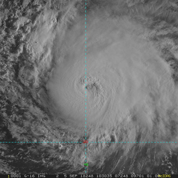
500 AM AST Wed Sep 05 2018

Conventional satellite enhanced BD-curve infrared imagery and a
0511 UTC GMI color composite microwave pass reveal improved inner
core structure with impressive outer banding over the eastern
semicircle. Dvorak intensity estimates have again increased, and
the initial intensity is once more increased to 90 kt, which also
agrees with the latest SATCON analysis.

This intensity forecast is still a bit murky. The deterministic
models show increasing southwesterly vertical shear and a less than
favorable mid-tropospheric thermodynamic environment affecting the
tropical cyclone over the next 48 hours. This less-than-conducive
environment should induce weakening during this time frame.
Thereafter, and through the remaining forecast, most of the
models show a mid- to upper-level low developing to the south of
Florence in the base of the mid- Atlantic deep-layer trough, which
should promote a somewhat more favorable diffluent upper wind
pattern. This more conducive upper wind pattern, and increasing sea
surface temperatures, is expected to cause Florence to restrengthen.
The NHC forecast is a little bit higher than the previous one
between the 48 and 96 hr periods to agree more with the IVCN and
NOAA-HCCA consensus forecasts.

Florence is estimated to be moving northwestward, or 305/11 kt,
which appears to be a temporary trochoidal eyewall wobble. A turn
back toward the west-northwest is expected later today, and this
general motion is expected to continue through day 4 while the
hurricane is steered by the southwestern periphery of the
subtropical ridge. By the end of the forecast period, Florence is
expected to turn northwestward and slow down as it enters a break in
the ridge. The ECMWF model track forecast has shifted significantly
toward the left this evening, closer to the other global models and
their ensemble means, indicating less steering influence from the
predicted growing weakness in the subtropical ridge. Subsequently,
an adjustment to the left of of the previous advisory, beyond 48
hours, was made in order to nudge closer to the guidance suite and
the consensus models.

FORECAST POSITIONS AND MAX WINDS

INIT 05/0900Z 21.4N 44.8W 90 KT 105 MPH
12H 05/1800Z 22.2N 46.3W 90 KT 105 MPH
24H 06/0600Z 23.2N 48.2W 80 KT 90 MPH
36H 06/1800Z 24.2N 50.0W 70 KT 80 MPH
48H 07/0600Z 24.9N 51.5W 70 KT 80 MPH
72H 08/0600Z 25.6N 54.1W 75 KT 85 MPH
96H 09/0600Z 26.8N 56.3W 80 KT 90 MPH
120H 10/0600Z 28.7N 58.2W 85 KT 100 MPH

$$
Forecaster Roberts
0 likes   
Visit the Caribbean-Central America Weather Thread where you can find at first post web cams,radars
and observations from Caribbean basin members Click Here

Shell Mound
Category 5
Category 5
Posts: 2434
Age: 31
Joined: Thu Sep 07, 2017 3:39 pm
Location: St. Petersburg, FL → Scandinavia

Re: ATL: FLORENCE - Hurricane - Discussion

#234 Postby Shell Mound » Wed Sep 05, 2018 6:16 am

Based on recent satellite imagery, Florence is very likely a 100-knot major hurricane now, with a well-defined eye clearing in the midst of a potent CDO. Early visible images confirm this trend. As with Matthew in 2016, the shear vectors appear to be venting the system rather than shearing it. In fact, the CDO and outflow have expanded westward a bit over the past several hours. Like Beryl, Florence appears to be thriving in an otherwise dry environment. The long-term movement is clearly to the northwest on satellite imagery. Comparison with the 00Z UKMET ensembles shows that Florence is consistently moving to the right of the UKMET in the short term. The WNW movement on the UKMET ensembles clearly isn't happening at this point. Notably, Florence is also persistently to the right of the ECMWF, especially compared to two days ago. The GFS has performed the best in terms of gauging the eastward-biased movement of Florence. However, the GFS has shifted considerably toward the UKMET/ECMWF in the medium to long term, owing to stronger ridging over the Eastern Seaboard, and shows a gradual westward turn commencing in a few days. The timing and amplitude of various troughs relative to Florence's location will be key factors.

06Z GFS: turns W at ~25°N 51°W
00Z UK: turns W at ~24°N 53°W (ensemble mean)
00Z EC: turns W at ~26°N 55°W

Image
Image
Image
Image

Two camps are evident on the 06Z GEFS ensembles by day five (ninety-six hours): a northern camp that feels the initial weakness and heads OTS, and a southern camp that turns W:

Image

Illustrative chart:

Image

Some important Twitter discussions:

 https://twitter.com/JackSillin/status/1037284955045462017


 https://twitter.com/webberweather/status/1037144641618030597


 https://twitter.com/webberweather/status/1037147750218059781


 https://twitter.com/webberweather/status/1037278226710765570


 https://twitter.com/webberweather/status/1037283760654442497


 https://twitter.com/webberweather/status/1037287869323337729


Last edited by Shell Mound on Wed Sep 05, 2018 7:20 am, edited 5 times in total.
1 likes   
CVW / MiamiensisWx / Shell Mound
The posts in this forum are NOT official forecasts and should not be used as such. They are just the opinion of the poster and may or may not be backed by sound meteorological data. They are NOT endorsed by any professional institution or STORM2K. For official information, please refer to products from the NHC and NWS.

Ntxw
Storm2k Moderator
Storm2k Moderator
Posts: 21565
Joined: Wed Oct 21, 2009 6:34 pm
Location: DFW, Texas

Re: ATL: FLORENCE - Hurricane - Discussion

#235 Postby Ntxw » Wed Sep 05, 2018 6:25 am

Eye needs to warm a bit more but very close to a major. Barring shear, this should be a major soon in the next update.

Image
1 likes   
The above post and any post by Ntxw is NOT an official forecast and should not be used as such. It is just the opinion of the poster and may or may not be backed by sound meteorological data. It is NOT endorsed by any professional institution including Storm2k. For official information, please refer to NWS products.

  Help support Storm2K!
Help Support Storm2K

User avatar
Hypercane_Kyle
Category 5
Category 5
Posts: 2911
Joined: Sat Mar 07, 2015 7:58 pm
Location: Cape Canaveral, FL

Re: ATL: FLORENCE - Hurricane - Discussion

#236 Postby Hypercane_Kyle » Wed Sep 05, 2018 6:36 am

Looks likely Florence will be upgraded to a major hurricane during the next advisory, eye has continued to warm.
0 likes   
My posts are my own personal opinion, defer to the National Hurricane Center (NHC) and other NOAA products for decision making during hurricane season.

User avatar
NDG
S2K Supporter
S2K Supporter
Posts: 14951
Joined: Sun Jul 09, 2006 10:14 pm
Location: Orlando, FL

Re: ATL: FLORENCE - Hurricane - Discussion

#237 Postby NDG » Wed Sep 05, 2018 6:51 am

Gordon could be around for at least 8-12 days, it will be one heck of a ACE maker for the Atlantic Basin.

Edit: I meant to say Florence, Gordon is still in my mind :lol:
Last edited by NDG on Wed Sep 05, 2018 6:58 am, edited 1 time in total.
2 likes   

tolakram
Admin
Admin
Posts: 19184
Age: 61
Joined: Sun Aug 27, 2006 8:23 pm
Location: Florence, KY (name is Mark)

Re: ATL: FLORENCE - Hurricane - Discussion

#238 Postby tolakram » Wed Sep 05, 2018 6:53 am

:uarrow: Florence :D

I will be rooting for Florence as long as it misses the US and Bermuda.
1 likes   
M a r k
- - - - -
Join us in chat: Storm2K Chatroom Invite. Android and IOS apps also available.

The posts in this forum are NOT official forecasts and should not be used as such. Posts are NOT endorsed by any professional institution or STORM2K.org. For official information and forecasts, please refer to NHC and NWS products.

User avatar
Emmett_Brown
Category 5
Category 5
Posts: 1344
Joined: Wed Aug 24, 2005 9:10 pm
Location: Sarasota FL

Re: ATL: FLORENCE - Hurricane - Discussion

#239 Postby Emmett_Brown » Wed Sep 05, 2018 6:54 am

Regarding ridges, and past observations, I have noticed the following over the years:

- Model trends in the 7-9 day range often continue to change for a bit before they settle down. This W trend may not be done yet. We saw this with Irma and Matthew recently, and notably with Ike a few years back.
- Storms that get shoved W by strong ridges often take on a Southerly component for a while. See Andrew and Katrina.
- While strong storms tend to go more N and be more prone to recurve before threatening the coast, it is not always the case. It all depends on the depth of the steering flow at all levels... so we should not automatically count on a stronger storm automatically going more poleward unless the steering flow allows it.
2 likes   

Ntxw
Storm2k Moderator
Storm2k Moderator
Posts: 21565
Joined: Wed Oct 21, 2009 6:34 pm
Location: DFW, Texas

Re: ATL: FLORENCE - Hurricane - Discussion

#240 Postby Ntxw » Wed Sep 05, 2018 7:00 am

Florence could easily get ~10 units with the latest forecast the next 5 days on top of the 5.6 units already there. Another ~10+ units after that for the following 5 days if it is a major. 25-35 unit system could be had in total.
1 likes   
The above post and any post by Ntxw is NOT an official forecast and should not be used as such. It is just the opinion of the poster and may or may not be backed by sound meteorological data. It is NOT endorsed by any professional institution including Storm2k. For official information, please refer to NWS products.


  Help support Storm2K!

Help Support Storm2K


Return to “2018”

Who is online

Users browsing this forum: No registered users and 7 guests