

ATL: MICHAEL - Post-Tropical - Discussion
Moderator: S2k Moderators
Re: ATL: MICHAEL - Hurricane - Discussion
Unusual number of lightning strikes on the eyewall
0 likes
-
tolakram
- Admin

- Posts: 20186
- Age: 62
- Joined: Sun Aug 27, 2006 8:23 pm
- Location: Florence, KY (name is Mark)
Re: ATL: MICHAEL - Hurricane - Discussion
0 likes
M a r k
- - - - -
Join us in chat: Storm2K Chatroom Invite. Android and IOS apps also available.
The posts in this forum are NOT official forecasts and should not be used as such. Posts are NOT endorsed by any professional institution or STORM2K.org. For official information and forecasts, please refer to NHC and NWS products.
-
meriland29

- Category 2

- Posts: 770
- Joined: Thu Aug 03, 2017 11:05 am
Re: ATL: MICHAEL - Hurricane - Discussion
It does look like the S side is warming up and losing convection a bit...for now. I am sure that is very temporary.
0 likes
-
OverlandHurricane
- S2K Supporter

- Posts: 58
- Joined: Thu Aug 28, 2008 4:50 pm
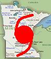
- Location: Minnesota
Re: ATL: MICHAEL - Hurricane - Discussion
DestinHurricane wrote:This is making me think I should have evaluated
Dude. Get out of there. NOW.
More importantly, at some point in the not-so-distant future, all the escape routes out of there will be under water. Don't wait around for that.
1 likes
-
StormPyrate
- Category 1

- Posts: 286
- Joined: Sun May 27, 2018 8:41 pm
- Location: Clearwater, FL
Re: ATL: MICHAEL - Hurricane - Discussion
tolakram wrote:dhweather wrote:StormPyrate wrote:South side seems to be dying down, shear or dry air?
It's not dry air, I just checked. Has to be shear.
Here is one theory. Click link to see 'thread".
https://twitter.com/pppapin/status/1049814078560956416
Cant reach it, but interesting
So what would weaken the convection coming in?
0 likes
St Petersburg Florida
-
SunnyThoughts
- Category 5

- Posts: 2263
- Joined: Wed Jul 09, 2003 12:42 pm
- Location: Pensacola, Florida
-
meriland29
- Category 2
- Posts: 770
- Joined: Thu Aug 03, 2017 11:05 am
Re: ATL: MICHAEL - Hurricane - Discussion
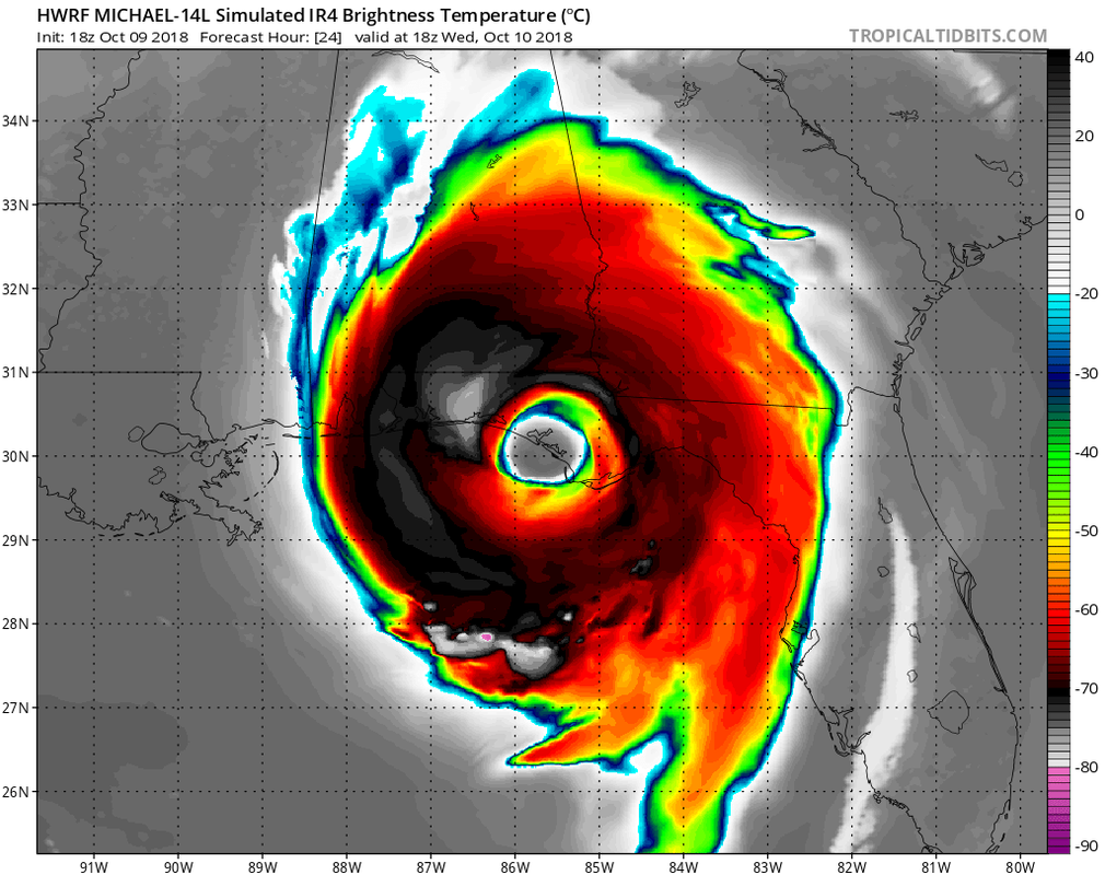
SunnyThoughts wrote:HWRF model simulation at landfall....No words
https://www.tropicaltidbits.com/analysi ... 00918&fh=6
Jesus..
1 likes
-
tolakram
- Admin
- Posts: 20186
- Age: 62
- Joined: Sun Aug 27, 2006 8:23 pm
- Location: Florence, KY (name is Mark)
Re: ATL: MICHAEL - Hurricane - Discussion
StormPyrate wrote:tolakram wrote:dhweather wrote:
It's not dry air, I just checked. Has to be shear.
Here is one theory. Click link to see 'thread".
https://twitter.com/pppapin/status/1049814078560956416
Cant reach it, but interesting
So what would weaken the convection coming in?
Drops from an earlier mission revealed dry air on the west side of the storm, while all other quadrants super moist.
Why is this still happening? An earlier G-IV flew & sampled the near-core env. of #Michael. Most of the profiles are moist, with the exception of dropsondes #24 & #25 which have a classic dry air import signal.
This is the likely culprit for why the SW eyewall remains open.
This is the likely culprit for why the SW eyewall remains open.
1 likes
M a r k
- - - - -
Join us in chat: Storm2K Chatroom Invite. Android and IOS apps also available.
The posts in this forum are NOT official forecasts and should not be used as such. Posts are NOT endorsed by any professional institution or STORM2K.org. For official information and forecasts, please refer to NHC and NWS products.
- - - - -
Join us in chat: Storm2K Chatroom Invite. Android and IOS apps also available.
The posts in this forum are NOT official forecasts and should not be used as such. Posts are NOT endorsed by any professional institution or STORM2K.org. For official information and forecasts, please refer to NHC and NWS products.
-
gatorcane

- S2K Supporter
- Posts: 23708
- Age: 48
- Joined: Sun Mar 13, 2005 3:54 pm
- Location: Boca Raton, FL
Re: ATL: MICHAEL - Hurricane - Discussion
SunnyThoughts wrote:HWRF model simulation at landfall....No words
https://www.tropicaltidbits.com/analysi ... 00918&fh=6
Wow
1 likes
-
jlauderdal
- S2K Supporter
- Posts: 7240
- Joined: Wed May 19, 2004 5:46 am
- Location: NE Fort Lauderdale
- Contact:
Re: RE: Re: ATL: MICHAEL - Hurricane - Discussion
Ri doesnt go on for days, bottom line is cat 4 at landfall is probable..big win for hwrf and euro for intensity.. euro was too slow so that's a loss, gfs nailed timing....big wind big surge, daytime landfall so anyone doubting the power of surge will see it tomorrow
PavelGaborik10 wrote:Blizzard96x wrote:PavelGaborik10 wrote:
What are you talking about? This storm IS exploding, and has been for quite some time.
The way the south side of Michael looks, I doubt winds are Cat 4 criteria.
I didn't say they were, but this storm has been undergoing RI for days now. It's a mere 5 MPH away from being a category 4 at this time.
0 likes
-
eastcoastFL

- Category 5
- Posts: 3996
- Age: 44
- Joined: Thu Apr 12, 2007 12:29 pm
- Location: Palm City, FL
Re: ATL: MICHAEL - Hurricane - Discussion
Is the western side flattening? IF so is that due to the trough pushing it or shear?
0 likes
Personal Forecast Disclaimer:
The posts in this forum are NOT official forecast and should not be used as such. They are just the opinion of the poster and may or may not be backed by sound meteorological data. They are NOT endorsed by any professional institution or storm2k.org. For official information, please refer to the NHC and NWS products.
The posts in this forum are NOT official forecast and should not be used as such. They are just the opinion of the poster and may or may not be backed by sound meteorological data. They are NOT endorsed by any professional institution or storm2k.org. For official information, please refer to the NHC and NWS products.
-
tolakram
- Admin
- Posts: 20186
- Age: 62
- Joined: Sun Aug 27, 2006 8:23 pm
- Location: Florence, KY (name is Mark)
Re: ATL: MICHAEL - Hurricane - Discussion
COD IR floater
https://weather.cod.edu/satrad/exper/?parms=meso-meso1-13-96-1-25-1&checked=map&colorbar=undefined
https://weather.cod.edu/satrad/exper/?parms=meso-meso1-13-96-1-25-1&checked=map&colorbar=undefined
0 likes
M a r k
- - - - -
Join us in chat: Storm2K Chatroom Invite. Android and IOS apps also available.
The posts in this forum are NOT official forecasts and should not be used as such. Posts are NOT endorsed by any professional institution or STORM2K.org. For official information and forecasts, please refer to NHC and NWS products.
- - - - -
Join us in chat: Storm2K Chatroom Invite. Android and IOS apps also available.
The posts in this forum are NOT official forecasts and should not be used as such. Posts are NOT endorsed by any professional institution or STORM2K.org. For official information and forecasts, please refer to NHC and NWS products.

Re: ATL: MICHAEL - Hurricane - Discussion
Michele B wrote:baygirl_1 wrote:DestinHurricane wrote:This is making me think I should have evaluated
There’s still time to leave and there are hotel rooms still available in Pensacola & Mobile. Be safe!
Yes! Go west. Most people drive north and keep driving north....then lots of folks are stranded on the roads. Get on 10 and GO WEST!
I believe you don 't have to go too far....just get OFF the beach and at least 20-40 miles inland - and on the west side of the storm.
Well spoken on both posts... I know that area ( did UG at UWF ) and have much experience driving in and out of storms due to both chasing & relief work and agree 100% y'all still have a few hours before weather deteriorates! And westbound there will be rooms in mobile or coastal Mississippi if Pensacola fills up or gets expensive.
But but but DO NOT EXPECT THERE TO BE ANY SERVICES GAS etc for a little while. If you have less than quater to half tank you run risk getting stuck traffic run outta gas. To find gas the gasbuddy site or app has a very good function to tell gas stations which have gas vs out of gas or no power etc. Governor Scott was plugging it a lot last year during that massive Irma evacuation. I found it very useful in my travels to aide in recent recovery mission Florence in eastern NC.
Last edited by smithtim on Tue Oct 09, 2018 8:59 pm, edited 3 times in total.
3 likes
Disclaimer: while I am PhD who does research I'm rambling here so this post should be taken only for entertainment...use nhc.noaa.gov for official forecasts!
FLoridian living round here for a while: 2016 Matthew & 1998 Earl lived barrier island landfall. Also lived nearby/inland for: 2017 Irma & 2004 Frances,Jeanne & 1992 Andrew
FLoridian living round here for a while: 2016 Matthew & 1998 Earl lived barrier island landfall. Also lived nearby/inland for: 2017 Irma & 2004 Frances,Jeanne & 1992 Andrew
-
cycloneye

- Admin
- Posts: 149709
- Age: 69
- Joined: Thu Oct 10, 2002 10:54 am
- Location: San Juan, Puerto Rico
Re: ATL: MICHAEL - Hurricane - Discussion
Impressive view from the International Space Station.
https://twitter.com/WorldAndScience/status/1049837029801033734
https://twitter.com/WorldAndScience/status/1049837029801033734
2 likes
Visit the Caribbean-Central America Weather Thread where you can find at first post web cams,radars
and observations from Caribbean basin members Click Here
and observations from Caribbean basin members Click Here
Re: ATL: MICHAEL - Hurricane - Discussion
Looks like a legit eye now.
Outflow channel is getting better connected with the ULL over the east tip of Cuba.
Last stop before landfall is the hot pool of water along the bend.
May make it to Cat 4.
Outflow channel is getting better connected with the ULL over the east tip of Cuba.
Last stop before landfall is the hot pool of water along the bend.
May make it to Cat 4.
0 likes
-
meriland29
- Category 2
- Posts: 770
- Joined: Thu Aug 03, 2017 11:05 am
Re: ATL: MICHAEL - Hurricane - Discussion
My phone is being wonky. Is recon coming in with more?
0 likes


Re: ATL: MICHAEL - Hurricane - Discussion
Water is up to Bamboo Willies on Pcola Beach.
For those not familiar it’s a bar on the boardwalk at Pensacola, Beach FL on the sound side.
For those not familiar it’s a bar on the boardwalk at Pensacola, Beach FL on the sound side.
Last edited by Taylormae on Tue Oct 09, 2018 8:57 pm, edited 1 time in total.
1 likes
-
PavelGaborik10
- Category 1
- Posts: 472
- Joined: Tue Sep 04, 2018 3:23 pm
Re: RE: Re: ATL: MICHAEL - Hurricane - Discussion
jlauderdal wrote:Ri doesnt go on for days, bottom line is cat 4 at landfall is probable..big win for hwrf and euro for intensity.. euro was too slow so that's a loss, gfs nailed timing....big wind big surge, daytime landfall so anyone doubting the power of surge will see it tomorrowPavelGaborik10 wrote:Blizzard96x wrote:
The way the south side of Michael looks, I doubt winds are Cat 4 criteria.
I didn't say they were, but this storm has been undergoing RI for days now. It's a mere 5 MPH away from being a category 4 at this time.
This storm has gone from a TD, or a category 3 in what, 48 hours...less? It may not have been RI'ing throughout the entire time period, but it damn sure was through the majority.
0 likes
-
srainhoutx

- S2K Supporter
- Posts: 6919
- Age: 68
- Joined: Sun Jan 14, 2007 11:34 am
- Location: Haywood County, NC
- Contact:
Re: ATL: MICHAEL - Hurricane - Discussion
Bay County officials were begging for help from the National Media to get word out this afternoon for people to evacuate. I hope and pray those 100K folks did heed the warnings to get out!
0 likes
Carla/Alicia/Jerry(In The Eye)/Michelle/Charley/Ivan/Dennis/Katrina/Rita/Wilma/Ike/Harvey
Member: National Weather Association
Wx Infinity Forums
http://wxinfinity.com/index.php
Facebook.com/WeatherInfinity
Twitter @WeatherInfinity
Member: National Weather Association
Wx Infinity Forums
http://wxinfinity.com/index.php
Facebook.com/WeatherInfinity
Twitter @WeatherInfinity
-
PavelGaborik10
- Category 1
- Posts: 472
- Joined: Tue Sep 04, 2018 3:23 pm
Who is online
Users browsing this forum: No registered users and 86 guests